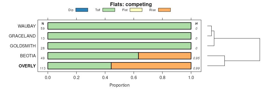
| Overly silty clay loam, 0 to 2 percent slopes | I383A | 5548 | 2798087 | 1nyyb | mn027 | 1980 | 1:20000 |
Overly silty clay loam | 506 | 846 | 1859450 | 20dx8 | mn101 | 2008 | 1:12000 |
Overly silty clay loam, 0 to 2 percent slopes | I383A | 1889 | 2799695 | 1nyyb | mn119 | 1996 | 1:20000 |
Overly silty clay loam, 0 to 2 percent slopes | I383A | 14 | 2800008 | 1nyyb | mn167 | 1985 | 1:20000 |
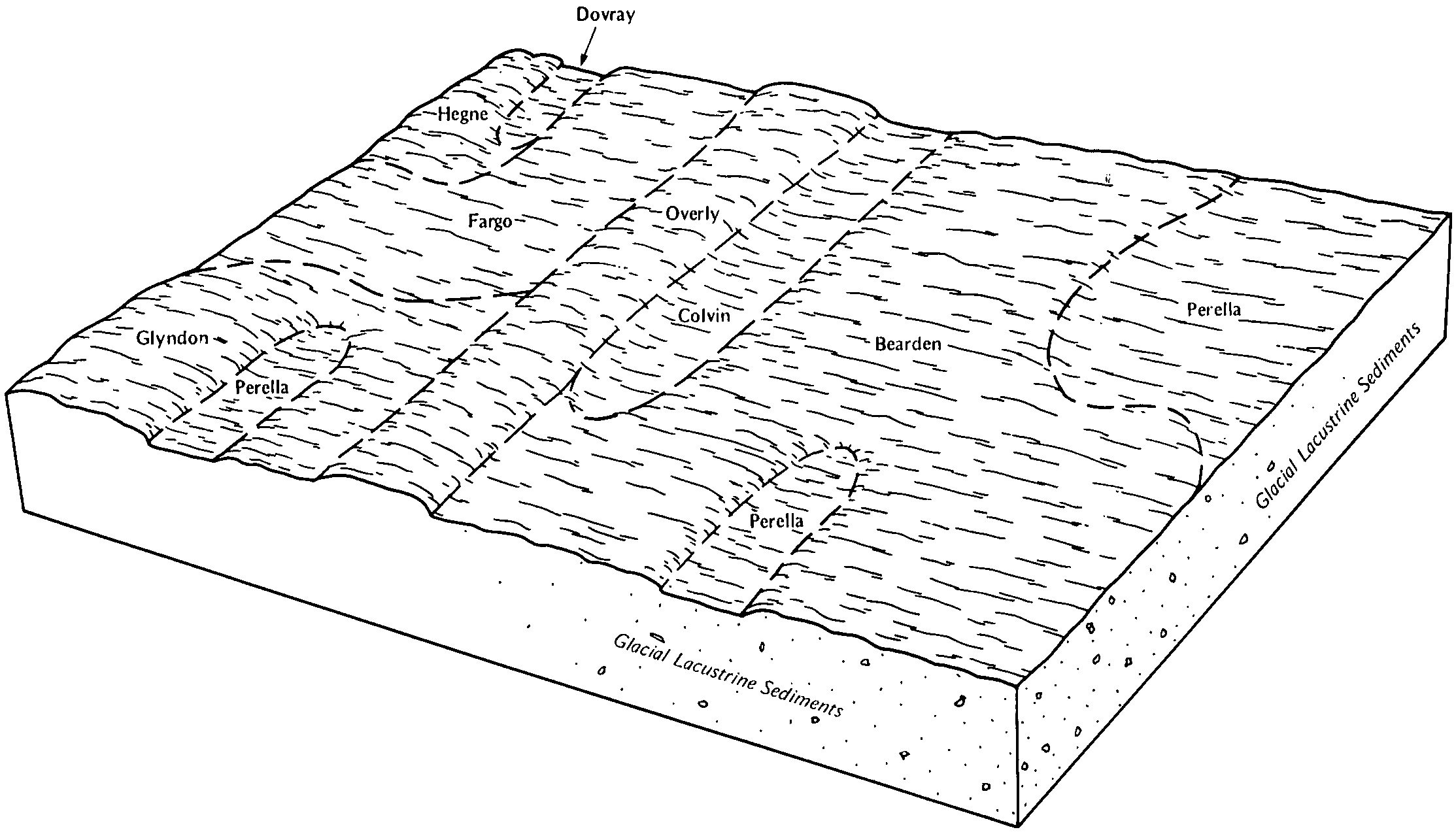
Overly-Bearden silty clay loams, 0 to 2 percent slopes | G506A | 6419 | 2573623 | 2q5p4 | nd003 | 1988 | 1:20000 |
Overly-Nahon silt loams, 0 to 2 percent slopes | G466A | 3521 | 2573616 | 2q5nd | nd003 | 1988 | 1:20000 |
Overly silty clay loam, 0 to 2 percent slopes | F481A | 3544 | 2587688 | 2q55z | nd005 | | 1:12000 |
Great Bend-Overly silt loams, 2 to 6 percent slopes | F482B | 1495 | 2587668 | 2q561 | nd005 | | 1:12000 |
Overly silty clay loam, 0 to 2 percent slopes | G481A | 228 | 2573742 | 2q5nm | nd005 | | 1:12000 |
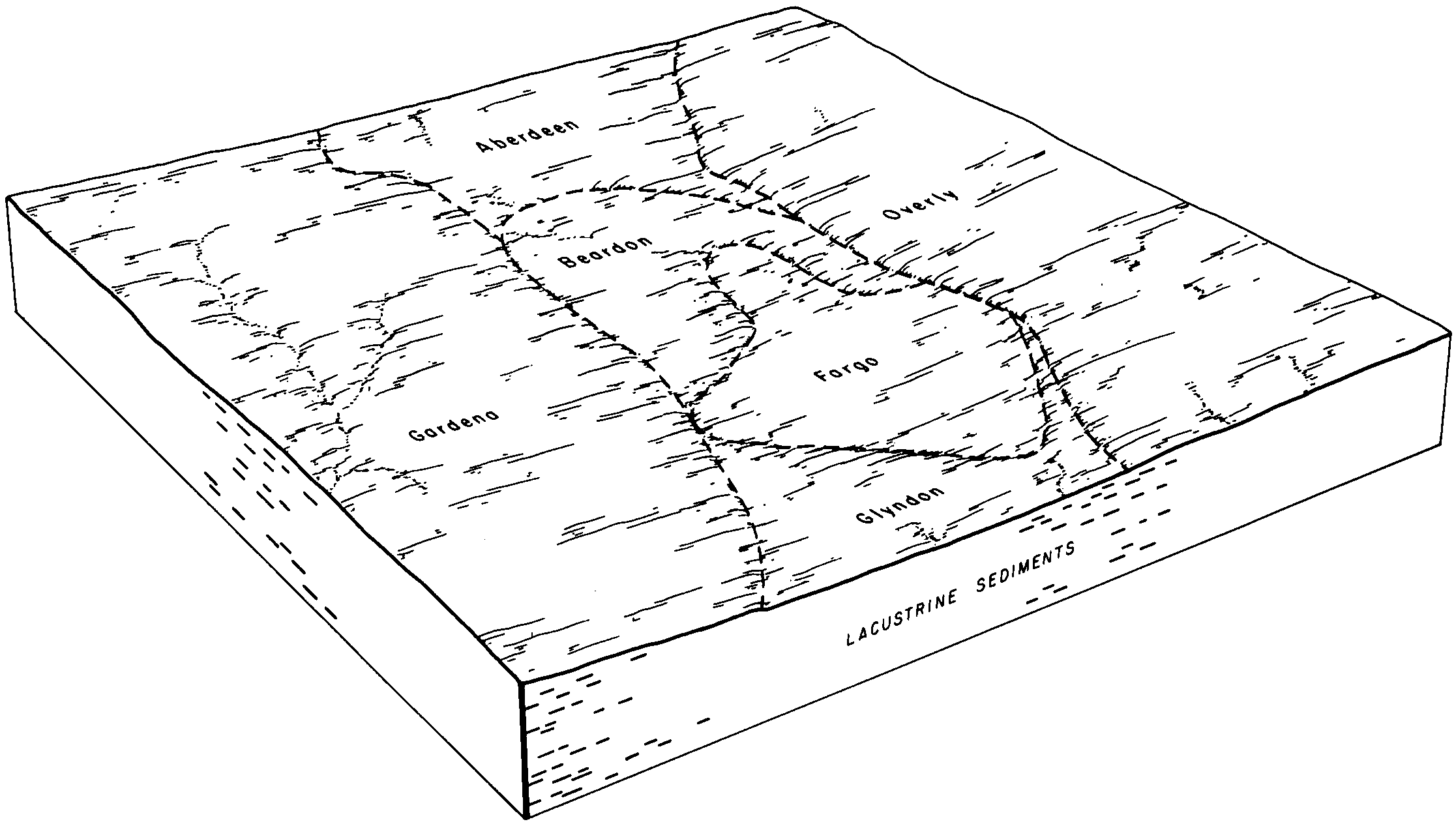
Aberdeen-Overly silt loams, 0 to 2 percent slopes | F465A | 37485 | 2586026 | 2q55w | nd009 | 1981 | 1:20000 |
Overly silty clay loam, 0 to 2 percent slopes | F481A | 22367 | 2585979 | 2q55z | nd009 | 1981 | 1:20000 |
Overly-Great Bend silty clay loams, 0 to 2 percent slopes | F487A | 17792 | 2585989 | 2q567 | nd009 | 1981 | 1:20000 |
Great Bend-Overly silt loams, 0 to 2 percent slopes | F482A | 558 | 2585908 | 2q560 | nd009 | 1981 | 1:20000 |
Overly-Bearden silt loams, 0 to 2 percent slopes | I482A | 10406 | 2521585 | 1tblz | nd017 | 1983 | 1:20000 |
Overly silty clay loam, 0 to 2 percent slopes | I383A | 7681 | 2640890 | 1nyyb | nd017 | 1983 | 1:20000 |
Overly silt loam, 0 to 2 percent slopes | I518A | 2547 | 2521606 | 1tbnt | nd017 | 1983 | 1:20000 |
Overly silty clay loam, 2 to 6 percent slopes | I383B | 1325 | 2640858 | 1tbl0 | nd017 | 1983 | 1:20000 |
Overly-Ryan silty clay loams, 0 to 2 percent slopes | I519A | 557 | 2640916 | 1tbns | nd017 | 1983 | 1:20000 |
Overly silt loam, 0 to 2 percent slopes | G480A | 1879 | 2575345 | 2q5nl | nd021 | 1989 | 1:20000 |
Aberdeen-Overly silt loams, 0 to 2 percent slopes | G465A | 1218 | 2575344 | 2q5nc | nd021 | 1989 | 1:20000 |
Great Bend-Overly silt loams, 0 to 2 percent slopes | G482A | 357 | 2576316 | 2q5nn | nd027 | | 1:12000 |
Bearden-Overly silty clay loams, 0 to 2 percent slopes | I628A | 8907 | 2642607 | 2pgbd | nd035 | 1980 | 1:20000 |
Overly silty clay loam, 0 to 2 percent slopes | I383A | 7999 | 2642554 | 1nyyb | nd035 | 1980 | 1:20000 |
Zell, fine-silty-Overly silt loams, 9 to 25 percent slopes | I660E | 34 | 2642611 | 2pyws | nd035 | 1980 | 1:20000 |
Overly silty clay, 0 to 2 percent slopes | I534A | 30 | 2642590 | 2mbmh | nd035 | 1980 | 1:20000 |
Overly silt loam, 0 to 2 percent slopes | I518A | 23 | 2642525 | 1tbnt | nd035 | 1980 | 1:20000 |
Overly silty clay loam, 0 to 1 percent slopes, fans | I531A | 8 | 2642591 | 2mbmj | nd035 | 1980 | 1:20000 |
Zell, fine-silty-Overly silt loams, 6 to 9 percent slopes | I660C | 2 | 2642612 | 2pywr | nd035 | 1980 | 1:20000 |
Aberdeen-Overly silt loams, 0 to 2 percent slopes | G465A | 230 | 2577086 | 2q5nc | nd045 | 1966 | 1:20000 |
Overly silt loam, 0 to 2 percent slopes | G480A | 161 | 2577087 | 2q5nl | nd045 | 1966 | 1:20000 |
Overly-Bearden silty clay loams, 0 to 2 percent slopes | G506A | 34 | 2577093 | 2q5p4 | nd045 | 1966 | 1:20000 |
Great Bend-Overly silt loams, 0 to 2 percent slopes | F482A | 5583 | 2585605 | 2q560 | nd049 | 1987 | 1:20000 |
Aberdeen-Overly silt loams, 0 to 2 percent slopes | F465A | 820 | 2585742 | 2q55w | nd049 | 1987 | 1:20000 |
Aberdeen-Overly silt loams, 0 to 2 percent slopes | G465A | 278 | 2571378 | 2q5nc | nd049 | 1987 | 1:20000 |
Overly silty clay loam, 0 to 2 percent slopes | F481A | 37 | 2585683 | 2q55z | nd049 | 1987 | 1:20000 |
Overly silty clay loam, 0 to 2 percent slopes | I383A | 7931 | 2642975 | 1nyyb | nd067 | 1972 | 1:20000 |
Overly silty clay, 0 to 2 percent slopes | I534A | 21 | 2643016 | 2mbmh | nd067 | 1972 | 1:20000 |
Overly silty clay loam, 0 to 2 percent slopes | F481A | 2276 | 2587243 | 2q55z | nd069 | 1975 | 1:20000 |
Great Bend-Overly silt loams, 0 to 2 percent slopes | F482A | 633 | 2587193 | 2q560 | nd069 | 1975 | 1:20000 |
Overly silty clay loam, 0 to 2 percent slopes | F481A | 2411 | 2587141 | 2q55z | nd071 | 1984 | 1:12000 |
Great Bend-Overly silt loams, 2 to 6 percent slopes | F482B | 625 | 2587143 | 2q561 | nd071 | 1984 | 1:12000 |
Great Bend-Overly silt loams, 0 to 2 percent slopes | F482A | 20 | 2587142 | 2q560 | nd071 | 1984 | 1:12000 |
Overly silty clay loam, 0 to 2 percent slopes | I383A | 1289 | 2641302 | 1nyyb | nd073 | 1992 | 1:20000 |
Overly silt loam, 0 to 2 percent slopes | G480A | 567 | 2581178 | 2q5nl | nd073 | 1992 | 1:20000 |
Great Bend-Overly silt loams, 0 to 2 percent slopes | F482A | 1727 | 2585346 | 2q560 | nd075 | 1972 | 1:20000 |
Overly silty clay loam, 0 to 2 percent slopes | I383A | 10322 | 2641114 | 1nyyb | nd077 | 2005 | 1:12000 |
Overly-Nutley silty clay loams, 2 to 6 percent slopes | I384B | 1159 | 2641132 | 1nyyc | nd077 | 2005 | 1:12000 |
Overly silty clay loam, sandy substratum, 0 to 2 percent slopes | I266A | 580 | 2641018 | 1nytz | nd077 | 2005 | 1:12000 |
Great Bend-Overly silt loams, 0 to 2 percent slopes | F482A | 4529 | 2588026 | 2q560 | nd079 | 1990 | 1:24000 |
Aberdeen-Overly silt loams, 0 to 2 percent slopes | F465A | 53 | 2588165 | 2q55w | nd079 | 1990 | 1:24000 |
Overly-Bearden silty clay loams, 0 to 2 percent slopes | G506A | 7272 | 2579483 | 2q5p4 | nd081 | 1959 | 1:12000 |
Overly-Bearden silty clay loams, nearly level | OyA | 2368 | 341616 | cggw | nd081 | 1959 | 1:12000 |
Overly silt loam, 0 to 2 percent slopes | G480A | 775 | 2579461 | 2q5nl | nd081 | 1959 | 1:12000 |
Overly silt loam, 0 to 2 percent slopes | I518A | 112 | 2641253 | 1tbnt | nd081 | 1959 | 1:12000 |
Great Bend-Overly silt loams, 2 to 6 percent slopes | G482B | 47 | 2579440 | 2q5np | nd081 | 1959 | 1:12000 |
Overly silty clay loam, 0 to 2 percent slopes | G481A | 31 | 2579488 | 2q5nm | nd081 | 1959 | 1:12000 |
Aberdeen-Overly silt loams, 0 to 2 percent slopes | G465A | 24 | 2579517 | 2q5nc | nd081 | 1959 | 1:12000 |
Overly silty clay loam, 0 to 2 percent slopes | G481A | 52 | 2581990 | 2q5nm | nd083 | 1990 | 1:20000 |
Overly silty clay loam, 0 to 2 percent slopes | I383A | 10110 | 2641380 | 1nyyb | nd091 | 1991 | 1:20000 |
Zell, fine-silty-Overly silt loams, 9 to 25 percent slopes | I660E | 4082 | 2641424 | 2pyws | nd091 | 1991 | 1:20000 |
Zell, fine-silty-Overly silt loams, 6 to 9 percent slopes | I660C | 2814 | 2641425 | 2pywr | nd091 | 1991 | 1:20000 |
Overly-Bearden silty clay loams, 0 to 2 percent slopes | G506A | 575 | 2581387 | 2q5p4 | nd093 | 1990 | 1:24000 |
Great Bend-Overly silt loams, 2 to 6 percent slopes | G482B | 53 | 2581385 | 2q5np | nd093 | 1990 | 1:24000 |
Great Bend-Overly silt loams, 0 to 2 percent slopes | F482A | 10432 | 2586206 | 2q560 | nd095 | 1992 | 1:24000 |
Great Bend-Overly silt loams, 2 to 6 percent slopes | F482B | 73 | 2587030 | 2q561 | nd095 | 1992 | 1:24000 |
Overly silty clay loam, 0 to 2 percent slopes | I383A | 13893 | 2641616 | 1nyyb | nd097 | 1974 | 1:20000 |
Bearden-Overly silty clay loams, 0 to 2 percent slopes | I628A | 9651 | 2642494 | 2pgbd | nd097 | 1974 | 1:20000 |
Overly-Fargo complex, 0 to 2 percent slopes | I175A | 2637 | 2642479 | 2l6xb | nd097 | 1974 | 1:20000 |
Overly-Great Bend silty clay loams, 2 to 6 percent slopes | I174B | 1542 | 2642480 | 2l6xc | nd097 | 1974 | 1:20000 |
Zell, fine-silty-Overly silt loams, 9 to 25 percent slopes | I660E | 135 | 2642496 | 2pyws | nd097 | 1974 | 1:20000 |
Zell, fine-silty-Overly silt loams, 6 to 9 percent slopes | I660C | 43 | 2642497 | 2pywr | nd097 | 1974 | 1:20000 |
Overly silty clay loam, 0 to 2 percent slopes | I383A | 12455 | 2642849 | 1nyyb | nd099 | 1967 | 1:20000 |
Overly silty clay loam, 0 to 1 percent slopes, fans | I531A | 9434 | 2642906 | 2mbmj | nd099 | 1967 | 1:20000 |
Overly silt loam, 0 to 2 percent slopes | I518A | 6919 | 2642875 | 1tbnt | nd099 | 1967 | 1:20000 |
Overly silty clay, 0 to 2 percent slopes | I534A | 3880 | 2642905 | 2mbmh | nd099 | 1967 | 1:20000 |
Overly silty clay, 0 to 1 percent slopes, fans | I537A | 3613 | 2642904 | 2mbmg | nd099 | 1967 | 1:20000 |
Overly silty clay loam, 2 to 6 percent slopes | I383B | 1124 | 2642864 | 1tbl0 | nd099 | 1967 | 1:20000 |
Bearden-Overly silty clay loams, 0 to 2 percent slopes | I628A | 59 | 2642927 | 2pgbd | nd099 | 1967 | 1:20000 |
Great Bend-Overly silt loams, 0 to 2 percent slopes | F482A | 209 | 2585130 | 2q560 | nd101 | 1967 | 1:20000 |
Overly silty clay loam, 0 to 2 percent slopes | G481A | 36 | 2573461 | 2q5nm | nd101 | 1967 | 1:20000 |
Overly silty clay loam, 0 to 2 percent slopes | G481A | 1102 | 2579663 | 2q5nm | nd103 | 1966 | 1:12000 |
Overly silty clay loam | Oa | 973 | 418168 | g149 | sd051 | 1977 | 1:20000 |
Aberdeen-Overly silt loams, 0 to 2 percent slopes | G465A | 11 | 2798811 | 2q5nc | sd089 | 1980 | 1:20000 |
Overly-Bearden silty clay loams, 0 to 2 percent slopes | G506A | 128 | 2799306 | 2q5p4 | sd091 | 1970 | 1:20000 |
Aberdeen-Overly silt loams, 0 to 2 percent slopes | G465A | 23 | 2799302 | 2q5nc | sd091 | 1970 | 1:20000 |