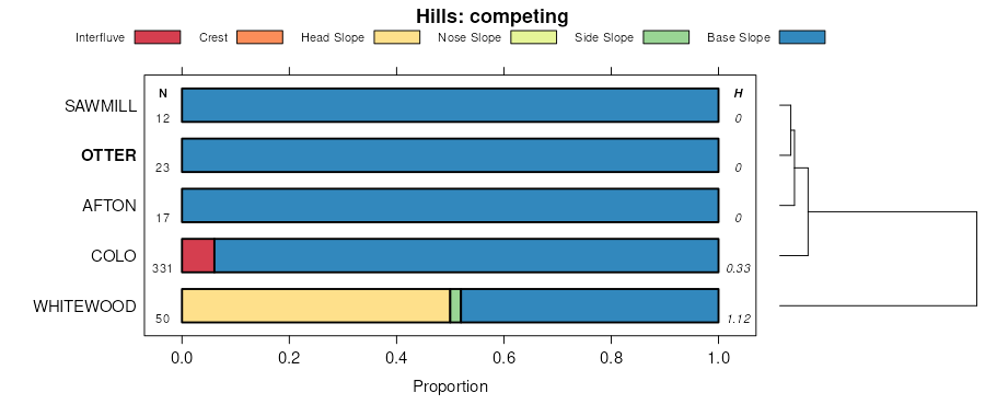
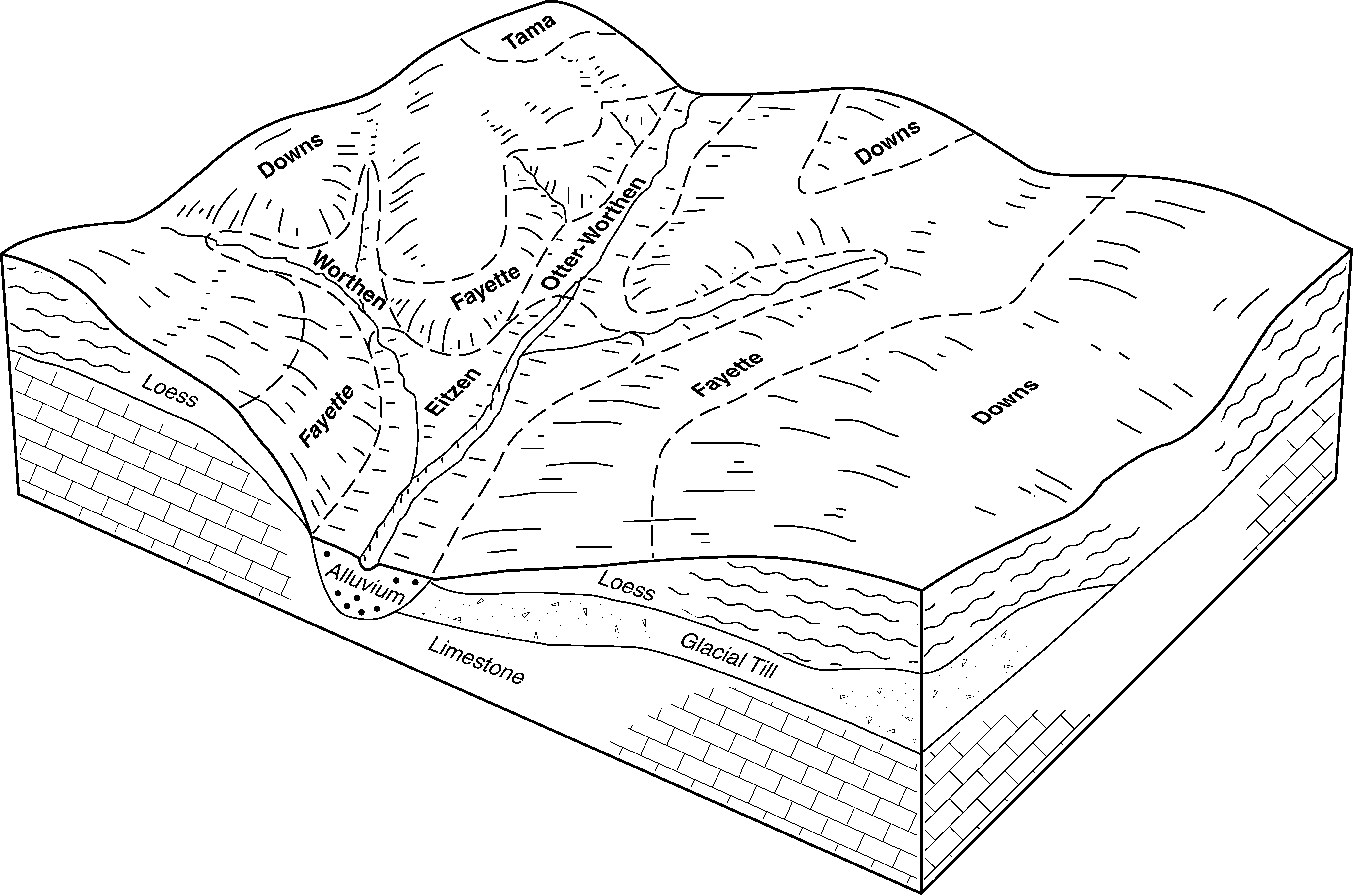
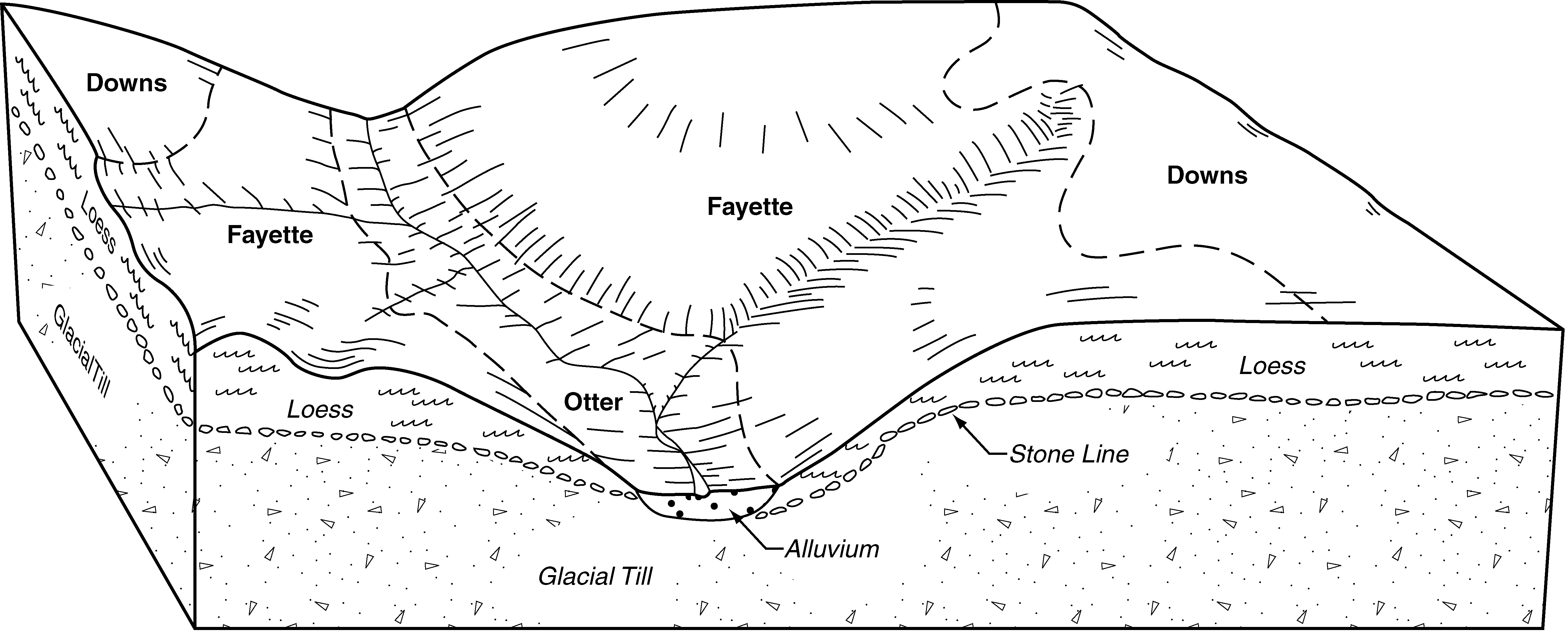
| Otter-Worthen complex, 1 to 4 percent slopes | 487B | 1609 | 402454 | fhsd | ia005 | 1992 | 1:15840 |
Otter silt loam, 0 to 2 percent slopes | 589 | 283 | 402474 | fht1 | ia005 | 1992 | 1:15840 |
Otter-Worthen silt loams, 1 to 4 percent slopes | 487B | 8610 | 404276 | fkp5 | ia043 | 1979 | 1:15840 |
Otter silt loam, 0 to 2 percent slopes | 589 | 1381 | 404291 | fkpn | ia043 | 1979 | 1:15840 |
Otter silt loam, overwash, 0 to 2 percent slopes | 589+ | 1211 | 404292 | fkpp | ia043 | 1979 | 1:15840 |
Otter-Worthen silt loams, 2 to 5 percent slopes | 487B | 3519 | 405446 | flwx | ia061 | 1983 | 1:15840 |
Otter silt loam, overwash, 0 to 2 percent slopes | 589+ | 2056 | 405464 | flxh | ia061 | 1983 | 1:15840 |
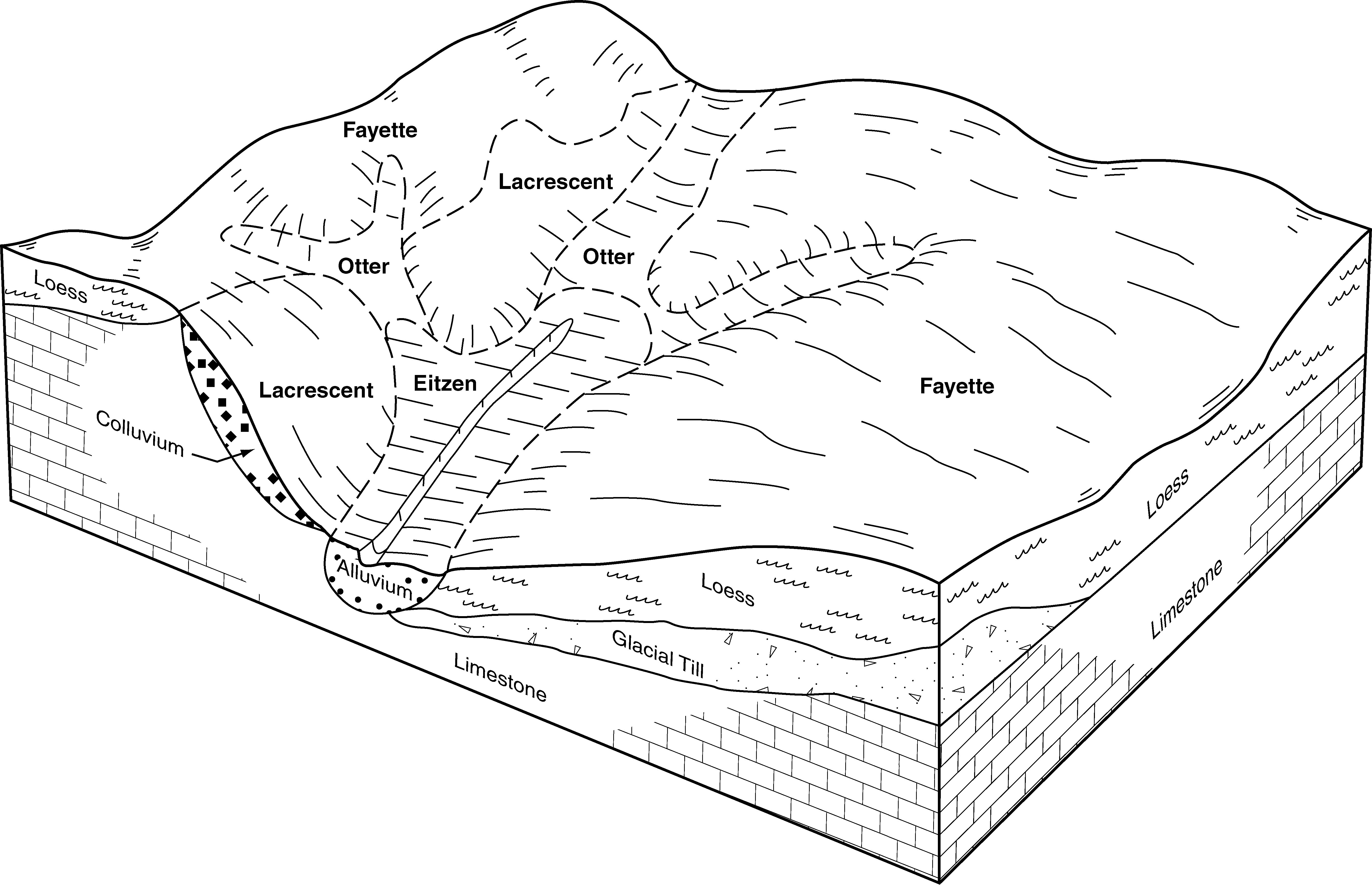
Otter-Huntsville silt loams, 2 to 5 percent slopes | 487B | 3491 | 405786 | fm7w | ia065 | 1975 | 1:15840 |
Otter silt loam, 0 to 2 percent slopes | 589 | 1727 | 407538 | fp2d | ia097 | 1988 | 1:15840 |
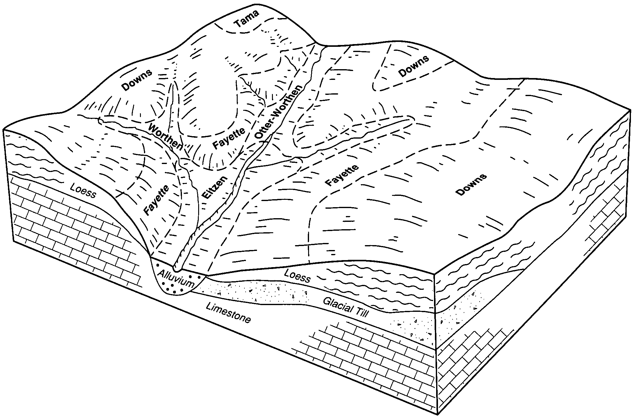
Worthen-Otter silt loams, 0 to 5 percent slopes | 487B | 1287 | 407521 | fp1v | ia097 | 1988 | 1:15840 |
Otter-Worthen complex, 1 to 4 percent slopes | 487B | 11179 | 1401621 | 1j1hl | ia191 | 2005 | 1:12000 |
Otter silt loam, 0 to 2 percent slopes, frequently flooded | 3076A | 1197 | 796030 | vqbd | il015 | 2005 | 1:12000 |
Otter silt loam, undrained, 0 to 2 percent slopes, frequently flooded | 1076A | 471 | 796034 | vqbj | il015 | 2005 | 1:12000 |
Otter silt loam, 0 to 2 percent slopes, rarely flooded | 7076A | 179 | 1542852 | 1nsgf | il015 | 2005 | 1:12000 |
Otter silt loam, 0 to 2 percent slopes, frequently flooded | 3076A | 11813 | 183887 | 65bv | il037 | 1998 | 1:12000 |
Otter-Lawson silt loams, 0 to 2 percent slopes, frequently flooded | 3725A | 9245 | 1412443 | 1jdrp | il071 | 2005 | 1:12000 |
Otter silt loam, 0 to 2 percent slopes, frequently flooded | 3076A | 4187 | 198787 | 6nvh | il089 | 2000 | 1:12000 |
Otter silt loam, 0 to 2 percent slopes, occasionally flooded | 8076A | 289 | 271320 | 93b8 | il089 | 2000 | 1:12000 |
Otter silt loam, 0 to 2 percent slopes, frequently flooded | 3076A | 291 | 1030105 | 13kx6 | il099 | 2006 | 1:12000 |
Otter silt loam, 0 to 2 percent slopes, occasionally flooded | 8076A | 1285 | 923928 | 100f4 | il103 | 2004 | 1:12000 |
Otter silt loam, 0 to 2 percent slopes, frequently flooded | 3076A | 83 | 1412392 | 1jdq1 | il103 | 2004 | 1:12000 |
Otter silt loam, 0 to 2 percent slopes, frequently flooded | 3076A | 1969 | 199213 | 6p97 | il117 | 1999 | 1:12000 |
Otter silt loam, 0 to 2 percent slopes, frequently flooded | 3076A | 2408 | 198692 | 6nrf | il161 | 2002 | 1:12000 |
Otter silt loam, undrained, 0 to 2 percent slopes, frequently flooded | 1076A | 1194 | 198686 | 6nr7 | il161 | 2002 | 1:12000 |
Otter silt loam, 0 to 2 percent slopes, rarely flooded | 7076A | 341 | 198700 | 6nrp | il161 | 2002 | 1:12000 |
Otter silt loam, 0 to 2 percent slopes, frequently flooded | 3076A | 1115 | 182942 | 64cc | il163 | 1997 | 1:12000 |
Otter silt loam, 0 to 2 percent slopes, occasionally flooded | 8076A | 259 | 2542391 | 2r1zh | il175 | 1992 | 1:15840 |
Otter silt loam, 0 to 2 percent slopes, frequently flooded | 3076A | 79 | 179121 | 60d3 | il175 | 1992 | 1:15840 |
Otter silt loam, 0 to 2 percent slopes, occasionally flooded | 8076A | 447 | 1651441 | 1sfg9 | il177 | 2006 | 1:12000 |
Otter silt loam, 0 to 2 percent slopes, frequently flooded | 3076A | 7 | 1542517 | 1ns3m | il189 | 2006 | 1:12000 |
Otter silt loam, 0 to 2 percent slopes, frequently flooded | 3076A | 1061 | 793111 | vm97 | il195 | 2003 | 1:12000 |
Otter silt loam, 0 to 2 percent slopes, rarely flooded | 7076A | 736 | 793125 | vm9p | il195 | 2003 | 1:12000 |
Otter-Lawson complex, bedrock substratum, 0 to 2 percent slopes, occasionally flooded | N595A | 649 | 1385062 | 1hh8f | mn039 | 2005 | 1:12000 |
Otter silt loam, drainageway, 0 to 2 percent slopes, frequently flooded | N522A | 336 | 1443757 | 1kgbt | mn039 | 2005 | 1:12000 |
Otter silt loam, channeled upland, 0 to 2 percent slopes, frequently flooded | N522A | 3290 | 1675256 | 1t77j | mn049 | 2007 | 1:12000 |
Otter silt loam, 0 to 2 percent slopes, occasionally flooded | N615A | 1175 | 1675356 | 1t7br | mn049 | 2007 | 1:12000 |
Otter silt loam | 468 | 1424 | 398962 | fd4r | mn079 | 1986 | 1:20000 |
Otter silt loam, channeled | 468 | 7119 | 400780 | fg1d | mn109 | 1977 | 1:15840 |
Otter silt loam | 468 | 408 | 1677123 | 1t95r | mn163 | 1978 | 1:15840 |
Otter silt loam | 468 | 1914 | 429053 | gdgf | mn169 | 1987 | 1:20000 |
Otter mucky silt loam, very wet | 1990 | 420 | 429017 | gdf8 | mn169 | 1987 | 1:20000 |
Blackoar and Otter silt loams, 0 to 2 percent slopes, occasionally flooded | 13504 | 24822 | 888027 | yt21 | mo107 | 1970 | 1:24000 |
Blackoar and Otter silt loams, 1 to 3 percent slopes and frequently flooded soils | 13621 | 15164 | 2544466 | 2qs14 | mo107 | 1970 | 1:24000 |
Otter silt loam | 609A | 5011 | 423322 | g6hk | wi021 | 1972 | 1:15840 |
Otter silt loam | 609A | 9415 | 753551 | t943 | wi025 | 1972 | 1:15840 |
Otter silt loam | 609A | 2381 | 423629 | g6tg | wi027 | 1976 | 1:15840 |
Otter silt loam, overwash | 609A | 1861 | 421818 | g4y1 | wi035 | 1974 | 1:12000 |
Otter silt loam, frequently flooded | 609A | 4716 | 425343 | g8lr | wi045 | 1969 | 1:12000 |
Otter silt loam | 609A | 1803 | 423813 | g70d | wi055 | 1976 | 1:15840 |
Otter silt loam, 0 to 2 percent slopes, frequently flooded | 609A | 353 | 2518483 | 1lmyb | wi063 | 2001 | 1:12000 |
Otter silt loam | 609A | 3152 | 426353 | g9nb | wi105 | 1970 | 1:20000 |
Otter silt loam | 609A | 876 | 423920 | g73v | wi117 | 1974 | 1:15840 |
Otter silt loam | 609A | 565 | 425758 | g914 | wi131 | 1967 | 1:15840 |