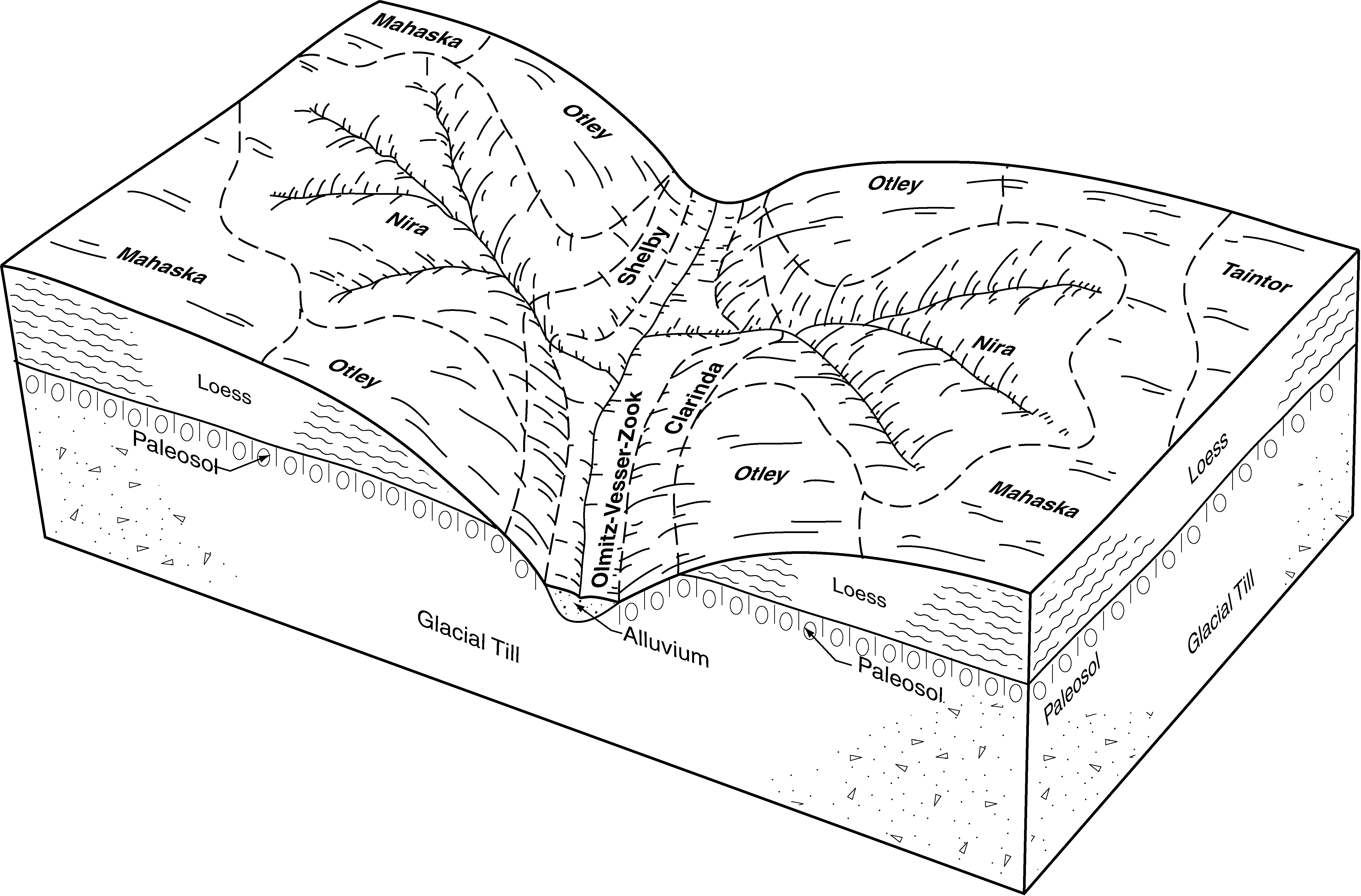
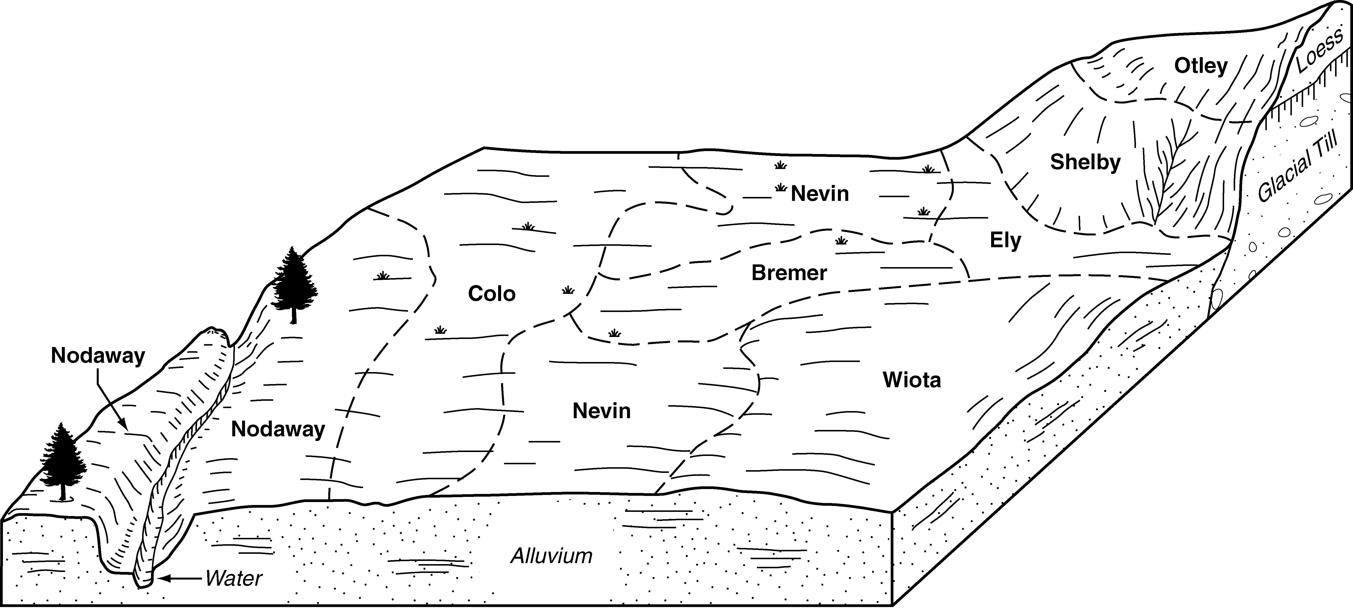
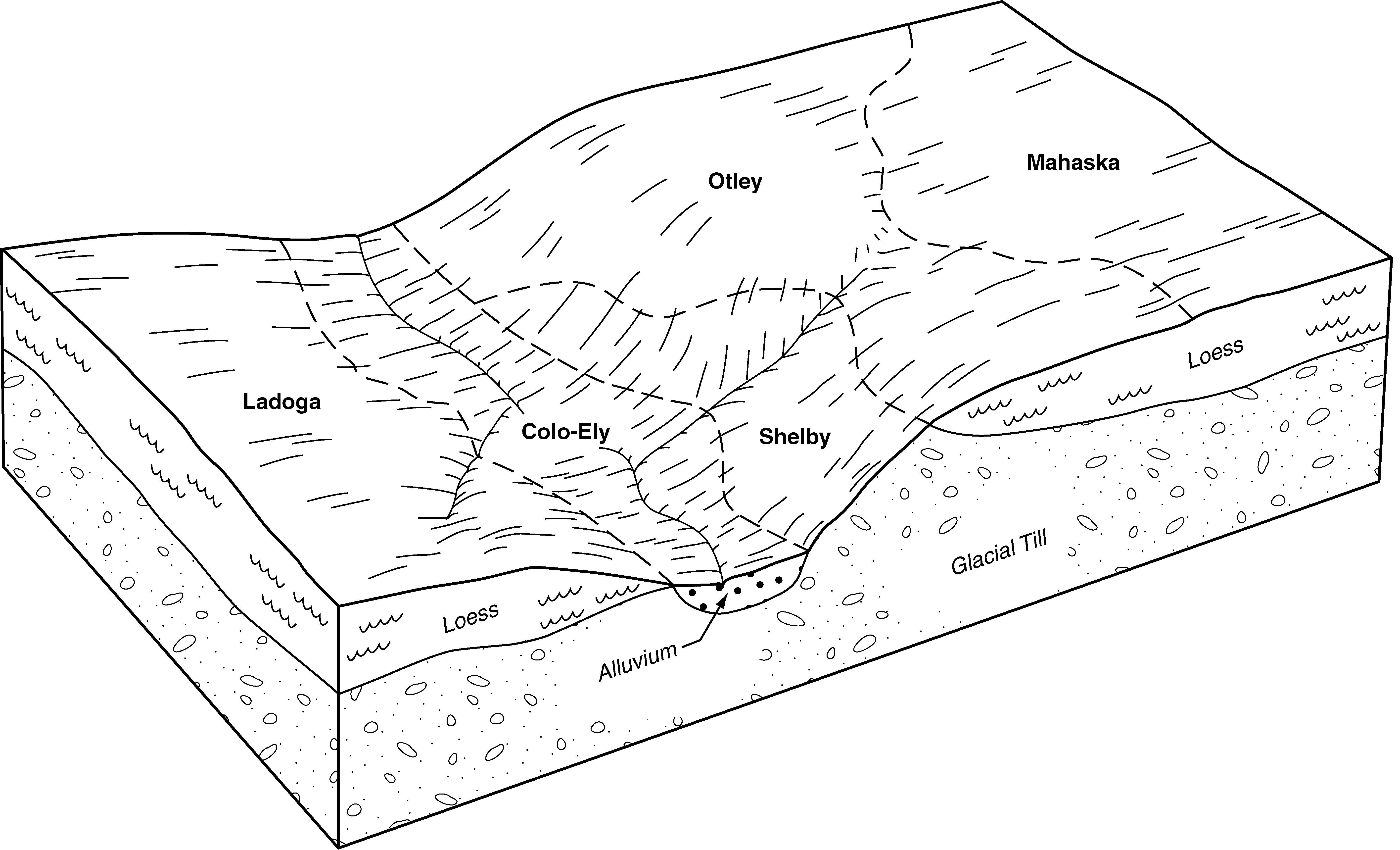
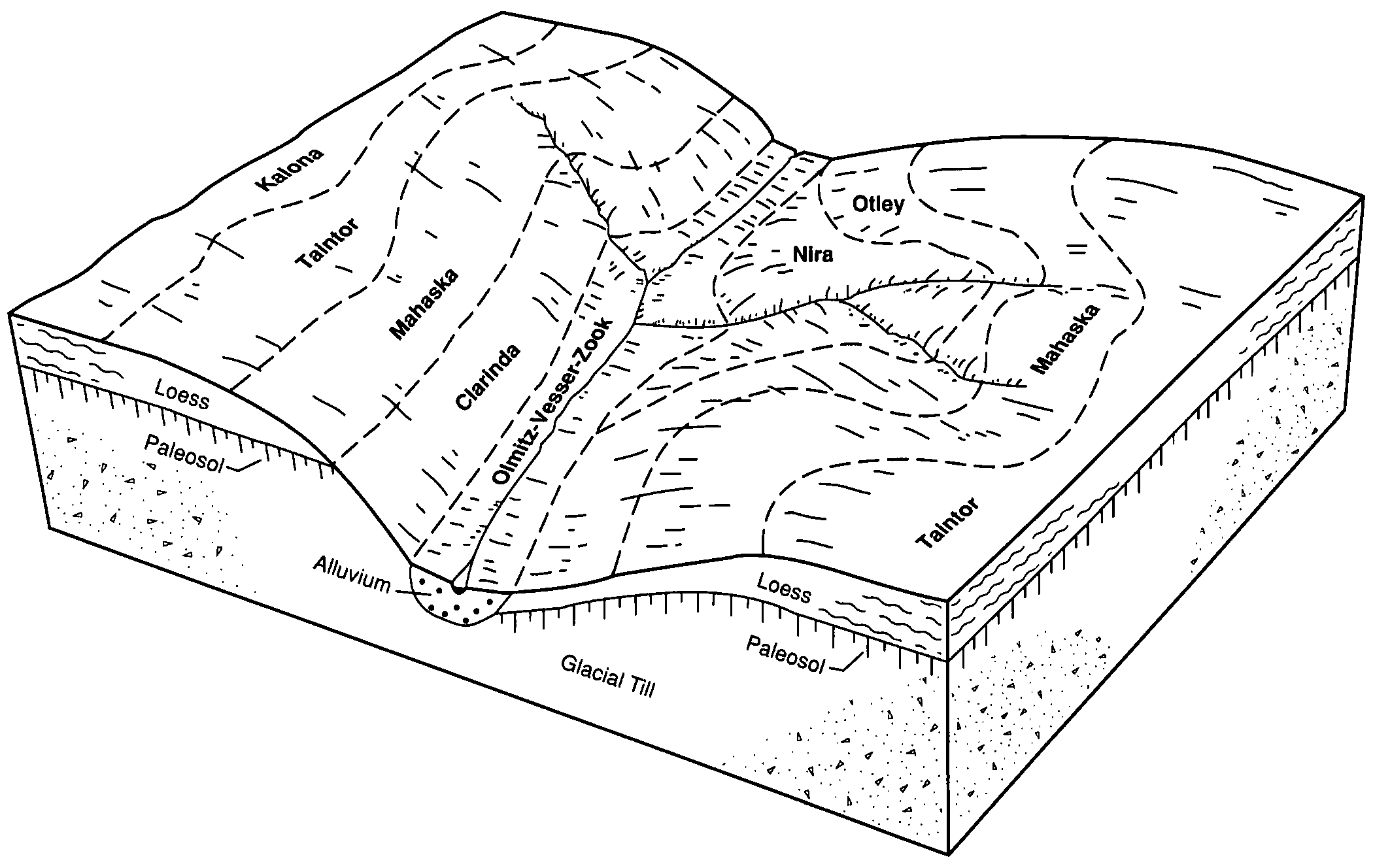
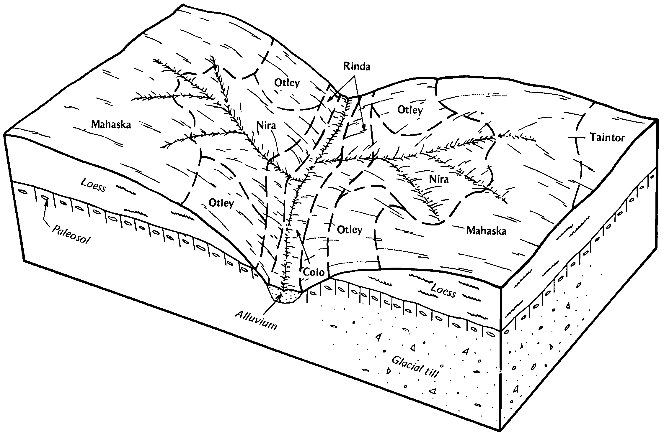
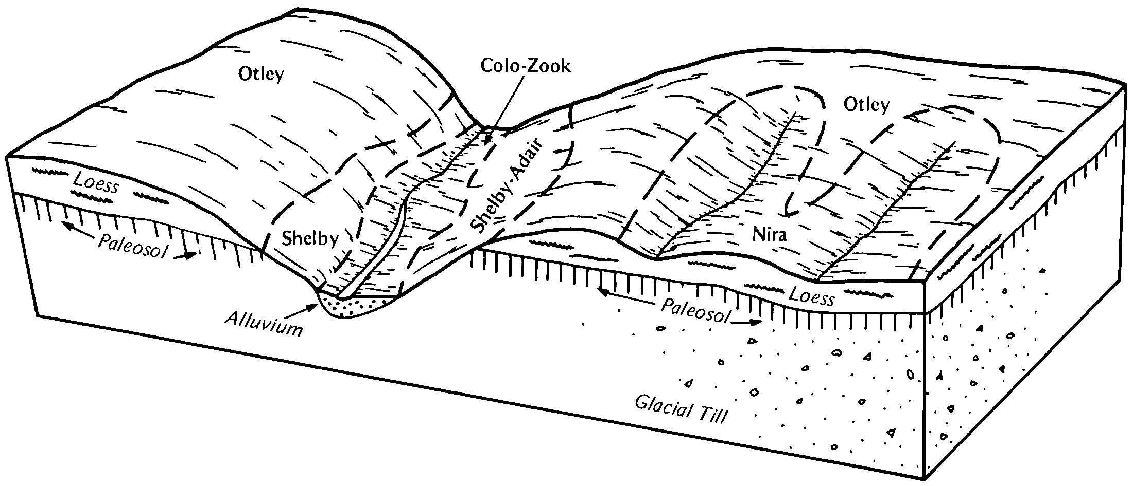
| Otley silty clay loam, 2 to 5 percent slopes | 281B | 3863 | 405237 | 2rlzx | ia057 | 1980 | 1:15840 |
Otley silty clay loam, 5 to 9 percent slopes, eroded | 281C2 | 1591 | 405238 | 2t3by | ia057 | 1980 | 1:15840 |
Otley silty clay loam, 2 to 5 percent slopes | 281B | 10888 | 406843 | 2rlzx | ia087 | 1982 | 1:15840 |
Otley silty clay loam, 5 to 9 percent slopes, eroded | 281C2 | 6177 | 406845 | 2t3by | ia087 | 1982 | 1:15840 |
Otley silty clay loam, 5 to 9 percent slopes | 281C | 3296 | 406844 | 2t3bx | ia087 | 1982 | 1:15840 |
Otley silty clay loam, terrace, 2 to 5 percent slopes | 881B | 627 | 406915 | 2t3c1 | ia087 | 1982 | 1:15840 |
Otley silty clay loam, terrace, 5 to 9 percent slopes, eroded | 881C2 | 140 | 406916 | 2t3c2 | ia087 | 1982 | 1:15840 |
Otley silty clay loam, 5 to 9 percent slopes, eroded | 281C2 | 17959 | 452989 | 2t3by | ia095 | 2005 | 1:12000 |
Otley silty clay loam, 2 to 5 percent slopes | 281B | 14625 | 452987 | 2rlzx | ia095 | 2005 | 1:12000 |
Otley silty clay loam, 9 to 14 percent slopes, eroded | 281D2 | 11995 | 452990 | 2t3bz | ia095 | 2005 | 1:12000 |
Otley silty clay loam, 5 to 9 percent slopes | 281C | 1749 | 452988 | 2t3bx | ia095 | 2005 | 1:12000 |
Otley silty clay loam, 9 to 14 percent slopes, severely eroded | 281D3 | 455 | 1144439 | 2t3c0 | ia095 | 2005 | 1:12000 |
Otley silty clay loam, terrace, 2 to 5 percent slopes | 881B | 256 | 1144441 | 2t3c1 | ia095 | 2005 | 1:12000 |
Otley silty clay loam, 14 to 18 percent slopes, moderately eroded | 281E2 | 181 | 1144440 | 17dwf | ia095 | 2005 | 1:12000 |
Otley silty clay loam, 5 to 9 percent slopes, eroded | 281C2 | 15092 | 407651 | 2t3by | ia099 | 1975 | 1:15840 |
Otley silty clay loam, 2 to 5 percent slopes | 281B | 11883 | 407650 | 2rlzx | ia099 | 1975 | 1:15840 |
Otley silty clay loam, 9 to 14 percent slopes, eroded | 281D2 | 5865 | 407652 | 2t3bz | ia099 | 1975 | 1:15840 |
Otley silty clay loam, 5 to 9 percent slopes, eroded | 281C2 | 5998 | 407783 | 2t3by | ia101 | 1992 | 1:15840 |
Otley silty clay loam, 2 to 5 percent slopes | 281B | 5795 | 407780 | 2rlzx | ia101 | 1992 | 1:15840 |
Otley silty clay loam, 2 to 5 percent slopes, eroded | 281B2 | 875 | 407781 | 2t3bw | ia101 | 1992 | 1:15840 |
Otley silty clay loam, 5 to 9 percent slopes | 281C | 397 | 407782 | 2t3bx | ia101 | 1992 | 1:15840 |
Otley silty clay loam, 2 to 5 percent slopes | 281B | 4390 | 407986 | 2rlzx | ia103 | 1979 | 1:15840 |
Otley silty clay loam, 5 to 9 percent slopes, eroded | 281C2 | 3633 | 407987 | 2t3by | ia103 | 1979 | 1:15840 |
Otley silty clay loam, 9 to 14 percent slopes, eroded | 281D2 | 852 | 407988 | 2t3bz | ia103 | 1979 | 1:15840 |
Otley silty clay loam, 2 to 5 percent slopes | 281B | 17984 | 447069 | 2rlzx | ia107 | 1998 | 1:12000 |
Otley silty clay loam, 5 to 9 percent slopes, eroded | 281C2 | 7983 | 447072 | 2t3by | ia107 | 1998 | 1:12000 |
Otley silty clay loam, 5 to 9 percent slopes | 281C | 499 | 447071 | 2t3bx | ia107 | 1998 | 1:12000 |
Otley silty clay loam, 2 to 5 percent slopes, eroded | 281B2 | 250 | 447070 | 2t3bw | ia107 | 1998 | 1:12000 |
Otley silty clay loam, terrace, 2 to 5 percent slopes | 881B | 215 | 447241 | 2t3c1 | ia107 | 1998 | 1:12000 |
Otley silty clay loam, 9 to 14 percent slopes, eroded | 281D2 | 192 | 447073 | 2t3bz | ia107 | 1998 | 1:12000 |
Otley silty clay loam, 2 to 5 percent slopes | 281B | 2889 | 408756 | 2rlzx | ia115 | 1984 | 1:15840 |
Otley silty clay loam, 5 to 9 percent slopes, eroded | 281C2 | 1583 | 408757 | 2t3by | ia115 | 1984 | 1:15840 |
Otley silty clay loam, 2 to 5 percent slopes | 281B | 27591 | 409305 | 2rlzx | ia123 | 1971 | 1:15840 |
Otley silty clay loam, 5 to 9 percent slopes, eroded | 281C2 | 12867 | 409307 | 2t3by | ia123 | 1971 | 1:15840 |
Otley silty clay loam, 5 to 9 percent slopes | 281C | 6573 | 409306 | 2t3bx | ia123 | 1971 | 1:15840 |
Otley silty clay loam, 9 to 14 percent slopes, eroded | 281D2 | 2088 | 409309 | 2t3bz | ia123 | 1971 | 1:15840 |
Otley silty clay loam, terrace, 2 to 5 percent slopes | T281B | 962 | 409395 | 2t3c1 | ia123 | 1971 | 1:15840 |
Sparta-Otley complex, 5 to 9 percent slopes, moderately eroded | 442C2 | 341 | 409329 | fqy5 | ia123 | 1971 | 1:15840 |
Otley silty clay loam, terrace, 5 to 9 percent slopes, eroded | T281C2 | 312 | 409396 | 2t3c2 | ia123 | 1971 | 1:15840 |
Sparta-Otley complex, 9 to 14 percent slopes, moderately eroded | 442D2 | 251 | 409330 | fqy6 | ia123 | 1971 | 1:15840 |
Otley silty clay loam, 9 to 14 percent slopes | 281D | 54 | 409308 | fqxh | ia123 | 1971 | 1:15840 |
Otley silty clay loam, 5 to 9 percent slopes, eroded | 281C2 | 6066 | 412761 | 2t3by | ia125 | 1976 | 1:15840 |
Otley silty clay loam, 2 to 5 percent slopes | 281B | 4674 | 412760 | 2rlzx | ia125 | 1976 | 1:15840 |
Otley silty clay loam, 9 to 14 percent slopes, eroded | 281D2 | 1878 | 412762 | 2t3bz | ia125 | 1976 | 1:15840 |
Otley silty clay loam, 2 to 5 percent slopes | 281B | 1989 | 409770 | 2rlzx | ia135 | 1982 | 1:15840 |
Otley silty clay loam, 5 to 9 percent slopes, eroded | 281C2 | 1527 | 409772 | 2t3by | ia135 | 1982 | 1:15840 |
Otley silty clay loam, 5 to 9 percent slopes | 281C | 840 | 409771 | 2t3bx | ia135 | 1982 | 1:15840 |
Otley silty clay loam, 5 to 9 percent slopes, eroded | 281C2 | 19032 | 410576 | 2t3by | ia157 | 1978 | 1:15840 |
Otley silty clay loam, 2 to 5 percent slopes | 281B | 17823 | 410574 | 2rlzx | ia157 | 1978 | 1:15840 |
Otley silty clay loam, 9 to 14 percent slopes, eroded | 281D2 | 2858 | 410577 | 2t3bz | ia157 | 1978 | 1:15840 |
Otley silty clay loam, terrace, 2 to 5 percent slopes | 881B | 885 | 410637 | 2t3c1 | ia157 | 1978 | 1:15840 |
Otley silty clay loam, 5 to 9 percent slopes | 281C | 631 | 410575 | 2t3bx | ia157 | 1978 | 1:15840 |
Otley silty clay loam, terrace, 5 to 9 percent slopes, eroded | 881C2 | 344 | 410638 | 2t3c2 | ia157 | 1978 | 1:15840 |
Otley silty clay loam, 2 to 5 percent slopes | 281B | 6468 | 411793 | 2rlzx | ia179 | 1978 | 1:15840 |
Otley-Nira silty clay loams, 5 to 9 percent slopes, moderately eroded | 581C2 | 5636 | 411823 | ftjm | ia179 | 1978 | 1:15840 |
Otley silty clay loam, 5 to 9 percent slopes | 281C | 4272 | 411794 | 2t3bx | ia179 | 1978 | 1:15840 |
Otley silty clay loam, terrace, 5 to 9 percent slopes, eroded | 881C2 | 1016 | 411867 | 2t3c2 | ia179 | 1978 | 1:15840 |
Otley silty clay loam, terrace, 2 to 5 percent slopes | 881B | 639 | 411866 | 2t3c1 | ia179 | 1978 | 1:15840 |
Otley silty clay loam, 2 to 5 percent slopes | 281B | 18267 | 412034 | 2rlzx | ia183 | 1983 | 1:15840 |
Otley silty clay loam, 5 to 9 percent slopes, eroded | 281C2 | 11575 | 412037 | 2t3by | ia183 | 1983 | 1:15840 |
Otley silty clay loam, 5 to 9 percent slopes, severely eroded | 281C3 | 1917 | 412038 | ftrk | ia183 | 1983 | 1:15840 |
Otley silty clay loam, 2 to 5 percent slopes, eroded | 281B2 | 1342 | 412035 | 2t3bw | ia183 | 1983 | 1:15840 |
Otley silty clay loam, terrace, 2 to 5 percent slopes | 881B | 921 | 412119 | 2t3c1 | ia183 | 1983 | 1:15840 |
Otley silty clay loam, 5 to 9 percent slopes | 281C | 717 | 412036 | 2t3bx | ia183 | 1983 | 1:15840 |
Otley silty clay loam, 9 to 14 percent slopes, eroded | 281D2 | 473 | 412039 | 2t3bz | ia183 | 1983 | 1:15840 |
Otley silty clay loam, 9 to 14 percent slopes, severely eroded | 281D3 | 245 | 412040 | 2t3c0 | ia183 | 1983 | 1:15840 |
