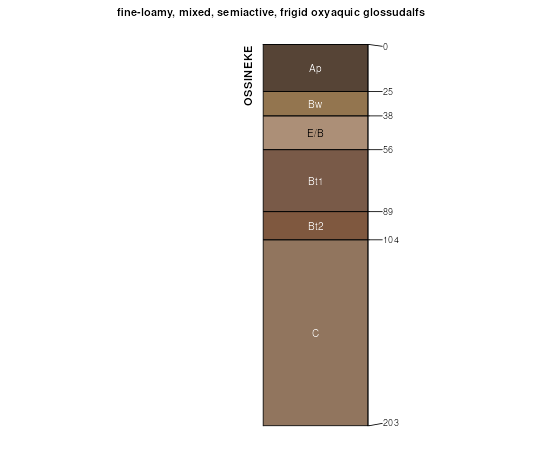
| Ossineke fine sandy loam, 0 to 6 percent slopes | 44B | 3367 | 190334 | 6d1t | mi001 | 1993 | 1:20000 |
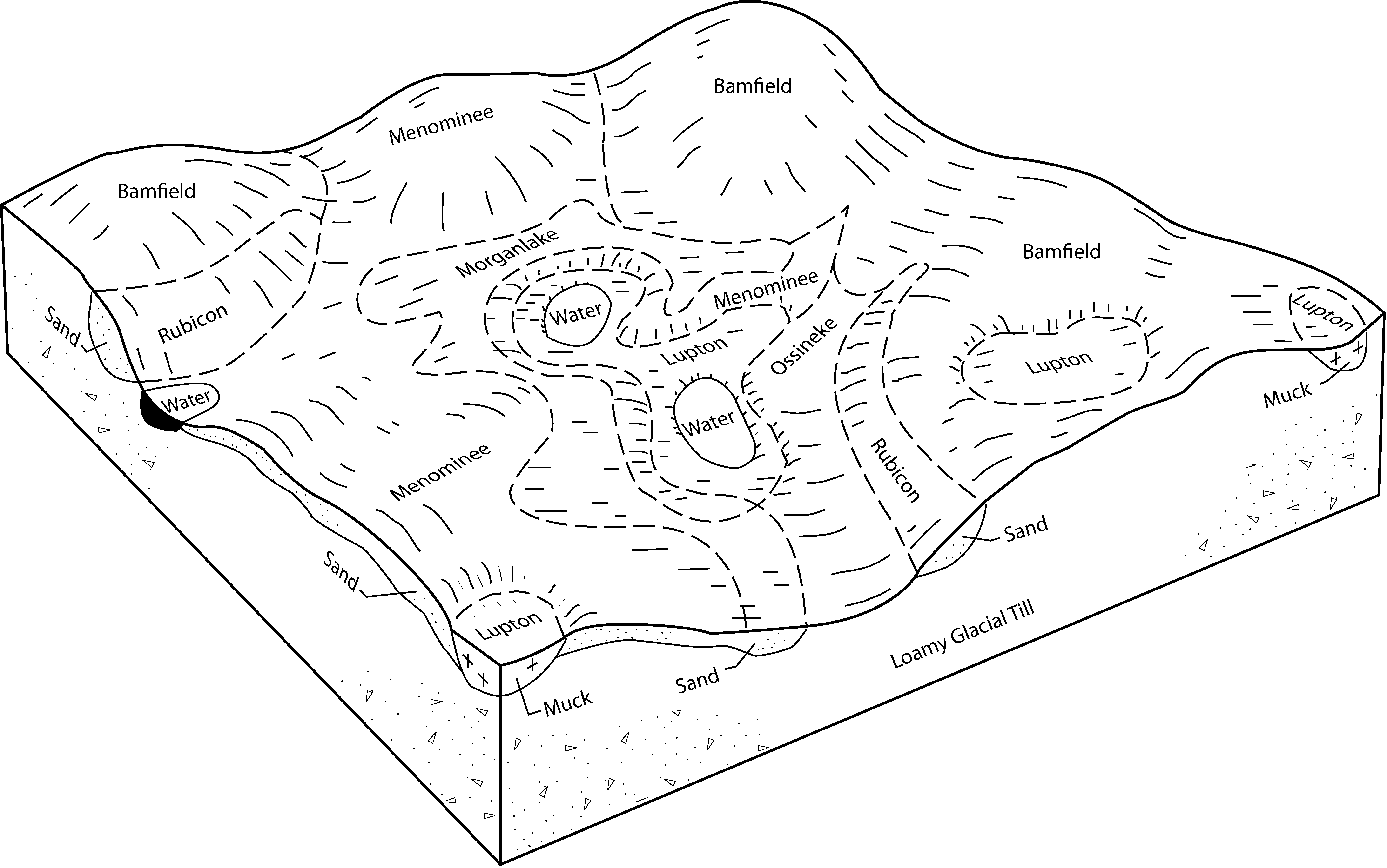
Glennie-Ossineke complex, nearly level and undulating | 247B | 376 | 190291 | 6d0f | mi001 | 1993 | 1:20000 |
Ossineke fine sandy loam, 0 to 6 percent slopes | 44B | 35227 | 191293 | 6f1r | mi007 | 1998 | 1:12000 |
Ossineke fine sandy loam, 6 to 12 percent slopes | 44C | 4190 | 191294 | 6f1s | mi007 | 1998 | 1:12000 |
Morganlake-Ossineke, sandy substratum-Blue Lake complex, 0 to 6 percent slopes | 424B | 47 | 191378 | 6f4h | mi007 | 1998 | 1:12000 |
Morganlake-Ossineke, sandy substratum-Blue Lake complex, 6 to 12 percent slopes | 424C | 4 | 191379 | 6f4j | mi007 | 1998 | 1:12000 |
Onaway-Ossineke fine sandy loams, moraine, 1 to 6 percent slopes | 7208 | 19258 | 2861552 | 2s5gc | mi041 | 1969 | 1:24000 |
Onaway-Ossineke fine sandy loams, drumlin, 1 to 6 percent slopes | 7209 | 8376 | 2861553 | 2s5gd | mi041 | 1969 | 1:24000 |
Ossineke fine sandy loam, 0 to 2 percent slopes | 7501 | 641 | 2861550 | 2s5g2 | mi041 | 1969 | 1:24000 |
Onaway-Ossineke fine sandy loams, drumlin, 1 to 6 percent slopes | 7209 | 4926 | 2861558 | 2s5gd | mi103 | 1999 | 1:24000 |
Onaway-Ossineke fine sandy loams, moraine, 1 to 6 percent slopes | 7208 | 1564 | 2861557 | 2s5gc | mi103 | 1999 | 1:24000 |
Onaway-Ossineke fine sandy loams, drumlin, 1 to 6 percent slopes | 7209 | 120698 | 2861568 | 2s5gd | mi109 | 1985 | 1:20000 |
Onaway-Ossineke fine sandy loams, moraine, 1 to 6 percent slopes | 7208 | 109 | 2861567 | 2s5gc | mi109 | 1985 | 1:20000 |
Ossineke fine sandy loam, 0 to 6 percent slopes | 44B | 5460 | 192299 | 6g36 | mi119 | 1997 | 1:12000 |
Morganlake-Ossineke, sandy substratum-Blue Lake complex, 0 to 6 percent slopes | 424B | 4010 | 192400 | 6g6g | mi119 | 1997 | 1:12000 |
Morganlake-Ossineke, sandy substratum-Blue Lake complex, 6 to 12 percent slopes | 424C | 2283 | 192401 | 6g6h | mi119 | 1997 | 1:12000 |
Ossineke fine sandy loam, 6 to 12 percent slopes | 44C | 1407 | 192300 | 6g37 | mi119 | 1997 | 1:12000 |
Mancelona-Ossineke-Blue Lake complex, 0 to 6 percent slopes | 353B | 479 | 192249 | 6g1l | mi119 | 1997 | 1:12000 |
Ossineke fine sandy loam, sandy substratum, 0 to 6 percent slopes | 453B | 18 | 190625 | 6dc6 | mi119 | 1997 | 1:12000 |
Ossineke fine sandy loam, 0 to 6 percent slopes | 44B | 1354 | 197584 | 6mlp | mi135 | 2003 | 1:12000 |
Morganlake-Ossineke, sandy substratum-Blue Lake complex, 6 to 12 percent slopes | 424C | 829 | 628170 | p2nk | mi135 | 2003 | 1:12000 |
Ossineke-Millersburg-Horsehead complex, 0 to 6 percent slopes | 505B | 764 | 209085 | 70kp | mi135 | 2003 | 1:12000 |
Glennie-Ossineke complex, rolling | 247C | 720 | 241461 | 8382 | mi135 | 2003 | 1:12000 |
Ossineke fine sandy loam, 6 to 12 percent slopes | 44C | 704 | 241427 | 836z | mi135 | 2003 | 1:12000 |
Morganlake-Ossineke, sandy substratum-Blue Lake complex, 0 to 6 percent slopes | 424B | 692 | 628171 | p2nl | mi135 | 2003 | 1:12000 |
Ossineke-Millersburg-Horsehead complex, 6 to 12 percent slopes | 505C | 462 | 209075 | 70kc | mi135 | 2003 | 1:12000 |
Glennie-Ossineke complex, nearly level and undulating | 247B | 141 | 241459 | 8380 | mi135 | 2003 | 1:12000 |
Ossineke fine sandy loam, sandy substratum, 0 to 6 percent slopes | 453B | 5807 | 191534 | 6f9j | mi137 | 1998 | 1:12000 |
Ossineke fine sandy loam, sandy substratum, 6 to 12 percent slopes | 453C | 1837 | 191535 | 6f9k | mi137 | 1998 | 1:12000 |
Morganlake-Ossineke, sandy substratum-Blue Lake complex, 0 to 6 percent slopes | 424B | 1817 | 191497 | 6f8b | mi137 | 1998 | 1:12000 |
Morganlake-0ssineke, sandy substratum,-Blue Lake complex, 6 to 12 percent slopes | 424C | 1469 | 191498 | 6f8c | mi137 | 1998 | 1:12000 |
Onaway-Ossineke fine sandy loams, moraine, 1 to 6 percent slopes | 7221B | 6471 | 2861500 | 2s5gc | wi009 | 1970 | 1:20000 |
Solona-Ossineke complex, 1 to 6 percent slopes | 7601B | 2575 | 2861501 | 2s5gf | wi009 | 1970 | 1:20000 |
Ossineke fine sandy loam, 0 to 2 percent slopes | 7521A | 778 | 2861497 | 2s5g2 | wi009 | 1970 | 1:20000 |
Onaway-Ossineke fine sandy loams, moraine, 1 to 6 percent slopes | 7221B | 34495 | 2861506 | 2s5gc | wi029 | 1975 | 1:15840 |
Ossineke fine sandy loam, 0 to 2 percent slopes | 7521A | 1511 | 2861502 | 2s5g2 | wi029 | 1975 | 1:15840 |
Onaway-Ossineke fine sandy loams, moraine, 1 to 6 percent slopes | 7221B | 7447 | 2861511 | 2s5gc | wi061 | 1978 | 1:15840 |
Ossineke fine sandy loam, 0 to 2 percent slopes | 7521A | 3 | 2861507 | 2s5g2 | wi061 | 1978 | 1:15840 |
Onaway-Ossineke fine sandy loams, drumlin, 1 to 6 percent slopes | 7121B | 45883 | 2861521 | 2s5gd | wi075 | 1987 | 1:20000 |
Onaway-Ossineke fine sandy loams, moraine, 1 to 6 percent slopes | 7221B | 4330 | 2861520 | 2s5gc | wi075 | 1987 | 1:20000 |
Solona-Ossineke complex, 1 to 6 percent slopes | 7601B | 2378 | 2861522 | 2s5gf | wi075 | 1987 | 1:20000 |
Ossineke fine sandy loam, 1 to 6 percent slopes | 7521B | 42 | 2861517 | 2s5g7 | wi075 | 1987 | 1:20000 |
Onaway-Ossineke fine sandy loams, moraine, 1 to 6 percent slopes | 7221B | 38145 | 2861538 | 2s5gc | wi083 | 1985 | 1:15840 |
Solona-Ossineke complex, 1 to 6 percent slopes | 7601B | 14213 | 2861540 | 2s5gf | wi083 | 1985 | 1:15840 |
Ossineke fine sandy loam, 1 to 6 percent slopes | 7521B | 9475 | 2861536 | 2s5g7 | wi083 | 1985 | 1:15840 |
Onaway-Ossineke fine sandy loams, drumlin, 1 to 6 percent slopes | 7121B | 7127 | 2861539 | 2s5gd | wi083 | 1985 | 1:15840 |
Onaway-Ossineke fine sandy loams, moraine, 1 to 6 percent slopes | 7221B | 14989 | 2861526 | 2s5gc | wi087 | 1975 | 1:15840 |
Solona-Ossineke complex, 1 to 6 percent slopes | 7601B | 8500 | 2861527 | 2s5gf | wi087 | 1975 | 1:15840 |
Ossineke fine sandy loam, 0 to 2 percent slopes | 7521A | 10 | 2861523 | 2s5g2 | wi087 | 1975 | 1:15840 |
Onaway-Ossineke fine sandy loams, moraine, 1 to 6 percent slopes | 7221B | 38248 | 2861546 | 2s5gc | wi115 | 1981 | 1:15840 |
Solona-Ossineke complex, 1 to 6 percent slopes | 7601B | 10068 | 2861547 | 2s5gf | wi115 | 1981 | 1:15840 |
Ossineke fine sandy loam, 0 to 2 percent slopes | 7521A | 1 | 2861542 | 2s5g2 | wi115 | 1981 | 1:15840 |