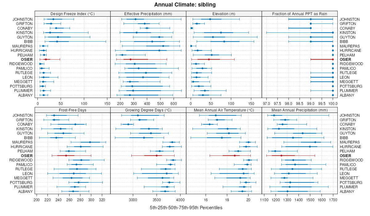
| Osier-Bibb complex | Ok | 5630 | 328082 | c0d9 | al001 | 1972 | 1:20000 |
Muckalee, Bibb, and Osier soils, 0 to 2 percent slopes, frequently flooded | MBA | 51125 | 328770 | c13h | al039 | 1985 | 1:20000 |
Sandy alluvial land, poorly drained | Sa | 36410 | 329031 | c1cx | al045 | 1958 | 1:20000 |
Bibb and Osier soils, frequently flooded | Bb | 23773 | 329618 | c1zv | al061 | 1973 | 1:20000 |
Bibb, Osier, and Kinston soils, 0 to 1 percent slopes, frequently flooded | BOA | 31335 | 608102 | nds6 | al069 | 2002 | 1:24000 |
Osier loamy sand, 0 to 2 percent slopes, occasionally flooded | OsA | 811 | 3117632 | 2x5st | al097 | 2018 | 1:24000 |
Osier fine sand, frequently flooded | 46 | 4645 | 1444903 | 1khjs | fl003 | 1991 | 1:20000 |
Osier fine sand | 31 | 11254 | 320820 | brv1 | fl005 | 1982 | 1:20000 |
Osier sand | 10 | 90 | 631622 | p67x | fl007 | 1988 | 1:15840 |
Rutlege-Osier complex, frequently flooded | 29 | 23800 | 132819 | 4g6h | fl019 | 1986 | 1:24000 |
Osier fine sand | 19 | 5850 | 132809 | 4g65 | fl019 | 1986 | 1:24000 |
Osier fine sand, occasionally flooded | 42 | 2860 | 132832 | 4g6x | fl019 | 1986 | 1:24000 |
Osier-Elloree complex, frequently flooded | 10 | 1358 | 1421080 | 1jpr9 | fl029 | 1998 | 1:24000 |
Elloree-Osier-Fluvaquents complex, frequently flooded | 16 | 6020 | 321799 | bsvm | fl041 | 1989 | 1:20000 |
Osier sand, occasionally flooded | 57 | 620 | 1148855 | 17kgv | fl047 | 1995 | 1:24000 |
Osier sand | 61 | 1865 | 322752 | btvc | fl077 | 2004 | 1:24000 |
Osier loamy fine sand, frequently flooded | 52 | 1920 | 132942 | 4gbg | fl089 | 1989 | 1:15840 |
Osier-Bibb-Albany complex, frequently flooded | 69 | 3423 | 1023383 | 13bxc | fl121 | 2003 | 1:24000 |
Clara and Osier fine sands | 3 | 6840 | 1425197 | 1jv13 | fl123 | 1998 | 1:24000 |
Osier sand | 10 | 300 | 1414576 | 1jgzh | fl125 | 1989 | 1:15840 |
Osier fine sand | 72 | 6230 | 324044 | bw61 | fl131 | 1985 | 1:20000 |
Osier loamy sand | Os | 2925 | 124164 | 4569 | ga021 | 1976 | 1:20000 |
Osier and Bibb soils, 0 to 2 percent slopes, frequently flooded | OI | 36621 | 324599 | 2wyxj | ga033 | 1982 | 1:20000 |
Osier and Bibb soils, 0 to 2 percent slopes, frequently flooded | OSA | 13090 | 754276 | 2wyxj | ga087 | 2001 | 1:24000 |
Osier and Bibb soils, 0 to 2 percent slopes, frequently flooded | OSA | 35750 | 336604 | 2wyxj | ga131 | 2000 | 1:12000 |
Myatt-Osier association | MO | 6240 | 324847 | bx0y | ga185 | 1975 | 1:20000 |
Osier soils and alluvial land | Osa | 9095 | 124927 | 45zx | ga229 | 1965 | 1:20000 |
Bibb and Osier soils | BO | 15265 | 324864 | bx1h | ga245 | 1979 | 1:15840 |
Kinston and Osier fine sandy loams | KO | 14683 | 324937 | bx3v | ga277 | 1979 | 1:20000 |
Kinston and Osier soils, 0 to 2 percent slopes, frequently flooded | KOA | 6435 | 2408358 | 2lv2z | ga299 | 2008 | 1:24000 |
Osier-Bibb association, frequently flooded | OB | 2150 | 125178 | 4680 | ga602 | 1983 | 1:20000 |
Osier-Pelham complex, 0 to 2 percent slopes, occasionally flooded | Op | 13215 | 325168 | 2wz2w | ga603 | 1981 | 1:20000 |
Osier and Bibb soils, 0 to 2 percent slopes, frequently flooded | Obs | 24649 | 325211 | 2wyxj | ga608 | 1965 | 1:20000 |
Johnston-Osier-Bibb association | Job | 31886 | 125350 | 46fk | ga609 | 1967 | 1:20000 |
Osier-Johnston-Bibb association | Ojb | 8835 | 125355 | 46fq | ga609 | 1967 | 1:20000 |
Kinston and Osier soils, 0 to 2 percent slopes, frequently flooded | KOA | 17570 | 2686772 | 2rz8s | ga611 | 2012 | 1:24000 |
Osier-Pelham complex, 0 to 2 percent slopes, frequently flooded | OS | 27035 | 325441 | 2wyxl | ga612 | 1975 | 1:20000 |
Myatt-Osier association | MO | 4165 | 325435 | bxmx | ga612 | 1975 | 1:20000 |
Kershaw-Osier complex | Kic | 5130 | 125380 | 46gj | ga613 | 1969 | 1:20000 |
Osier fine sand | Om | 2100 | 125394 | 46gz | ga613 | 1969 | 1:20000 |
Osier loamy fine sand, 0 to 2 percent slopes, frequently flooded | OS | 69160 | 325534 | 2wyxk | ga617 | 1976 | 1:20000 |
Osier-Pelham complex, 0 to 2 percent slopes, frequently flooded | OP | 39365 | 325561 | 2wyxl | ga627 | 1970 | 1:20000 |
Kinston and Osier soils | KO | 9457 | 325596 | bxt3 | ga631 | 1978 | 1:20000 |
Osier and Bibb soils, 0 to 2 percent slopes, frequently flooded | BB | 32711 | 325817 | 2wyxj | ga638 | 1987 | 1:20000 |
Osier and Bibb soils | Os | 5845 | 125818 | 46xn | ga644 | 1980 | 1:20000 |
Osier and Bibb soils, 0 to 2 percent slopes, frequently flooded | Obs | 64555 | 326061 | 2wyxj | ga647 | 1970 | 1:20000 |
Osier and Bibb soils, 0 to 2 percent slopes, frequently flooded | BO | 35385 | 326199 | 2wyxj | ga650 | 1994 | 1:20000 |
Osier sand, 0 to 2 percent slopes | OsB | 2626 | 1725719 | 1vxrc | la011 | 1993 | 1:24000 |
Cadeville-Osier complex (aqualfs), 1 to 8 percent slopes | AsC | 1383 | 569945 | m42b | la079 | 1973 | 1:24000 |
Osier loamy fine sand, 0 to 2 percent slopes | OsB | 2949 | 1725565 | 1vxld | la115 | 1992 | 1:24000 |
Osier loamy fine sand, 0 to 2 percent slopes | Os | 4539 | 1725970 | 1vy0g | la127 | 1991 | 1:24000 |
Trebloc and Osier soils | Ts | 26398 | 332869 | c5cq | ms073 | 1969 | 1:20000 |
Osier fine sand | Os | 573 | 112123 | 3rnw | nc053 | 1980 | 1:20000 |
Osier fine sand, 0 to 2 percent slopes, rarely flooded | OsA | 1373 | 110988 | 3qh8 | nc055 | 1987 | 1:24000 |
Osier loamy sand, loamy substratum (Plummer) | Os | 4043 | 114339 | 3tzc | nc147 | 1969 | 1:15840 |
Plummer and Osier soils | Pm | 5982 | 114785 | 3vfr | nc155 | 1972 | 1:20000 |
Plummer and Osier soils, 0 to 2 percent slopes | PuA | 2626 | 1480499 | 1lpl1 | nc165 | 2006 | 1:12000 |
Osier loamy sand, 0 to 2 percent slopes, rarely flooded | OsA | 662 | 1480502 | 1lpl4 | nc165 | 2006 | 1:12000 |
Osier-Pickney complex, frequently flooded | Oy | 3303 | 132391 | 4frp | sc005 | 1989 | 1:20000 |
Grifton-Osier complex, 0 to 2 percent slopes, frequently flooded | GsA | 12286 | 138105 | 4mq0 | sc009 | 1997 | 1:24000 |
Osier loamy sand, 0 to 2 percent slopes, frequently flooded | OsA | 2405 | 138130 | 4mqt | sc009 | 1997 | 1:24000 |
Fluvaquents-Osier-Grifton complex, 0 to 2 percent slopes, frequently flooded | FsA | 1670 | 138113 | 4mq8 | sc009 | 1997 | 1:24000 |
Osier loamy sand | Os | 1777 | 132431 | 4fsz | sc013 | 1975 | 1:20000 |
Osier loamy fine sand | Os | 4278 | 132236 | 4flp | sc027 | 1972 | 1:20000 |
Torhunta-Osier association | 73 | 18103 | 132303 | 4fnv | sc029 | 1980 | 1:20000 |
Osier loamy sand | 49 | 4013 | 132285 | 4fn8 | sc029 | 1980 | 1:20000 |
Osier loamy sand | Os | 3610 | 129764 | 4c0y | sc033 | 1976 | 1:20000 |
Osier loamy fine sand, frequently flooded | Os | 11600 | 129820 | 4c2r | sc035 | 1985 | 1:20000 |
Osier loamy sand | Os | 7064 | 129976 | 4c7s | sc041 | 1969 | 1:20000 |
Grifton-Osier complex, frequently flooded | Gr | 18641 | 130107 | 4cd0 | sc049 | 1990 | 1:20000 |
Osier-Pickney complex, frequently flooded | Oy | 6916 | 130120 | 4cdf | sc049 | 1990 | 1:20000 |
Osier loamy sand | Oe | 1254 | 130119 | 4cdd | sc049 | 1990 | 1:20000 |
Osier loamy sand | Os | 4380 | 130162 | 4cfs | sc051 | 1983 | 1:20000 |
Osier loamy sand | Os | 2857 | 132568 | 4fyd | sc053 | 1975 | 1:20000 |
Osier loamy sand | Os | 1750 | 130576 | 4cw4 | sc067 | 1975 | 1:20000 |
Scranton loamy fine sand | Sf | 5430 | 138302 | 4mxc | sc690 | 1967 | 1:24000 |
Osier fine sand | Os | 1476 | 138292 | 4mx1 | sc690 | 1967 | 1:24000 |
Osier-Alaga complex, rarely flooded | Oc | 908 | 575599 | m9yq | tx339 | 1967 | 1:20000 |
Osier loamy fine sand | 23 | 545 | 118956 | 3zs9 | va073 | 1978 | 1:15840 |
Osier loamy fine sand, 0 to 2 percent slopes, rarely flooded | 20A | 629 | 694707 | r9wx | va101 | 1995 | 1:15840 |