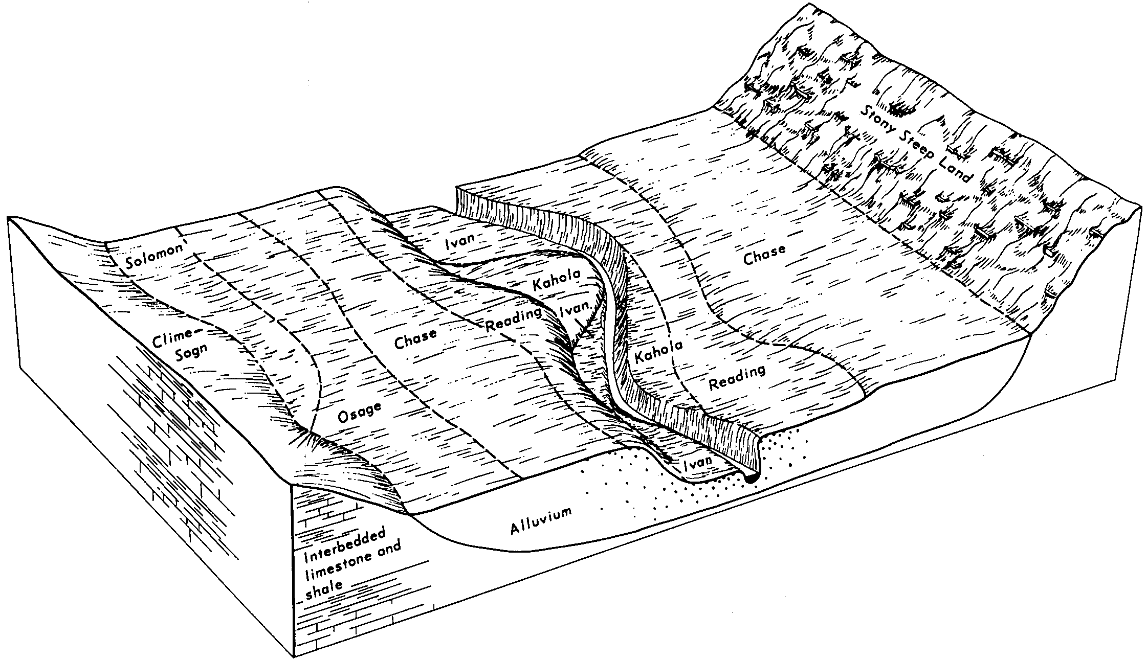
| Osage silty clay loam, 0 to 1 percent slopes, occasionally flooded | 8201 | 4203 | 1427106 | 2tgsy | ks001 | 1975 | 1:24000 |
Osage silty clay, 0 to 1 percent slopes, occasionally flooded | 8203 | 3801 | 1427107 | 2tgsw | ks001 | 1975 | 1:24000 |
Osage silty clay loam, 0 to 1 percent slopes, occasionally flooded | 8201 | 4463 | 1427945 | 2tgsy | ks003 | 1974 | 1:24000 |
Osage silty clay, 0 to 1 percent slopes, occasionally flooded | 8203 | 116 | 1427946 | 2tgsw | ks003 | 1974 | 1:24000 |
Osage silty clay, 0 to 1 percent slopes, occasionally flooded | 8203 | 4071 | 1427051 | 2tgsw | ks011 | 1979 | 1:24000 |
Osage silty clay, occasionally flooded | 8203 | 2028 | 1382899 | 2xlhb | ks015 | 1970 | 1:24000 |
Osage silty clay, 0 to 1 percent slopes, occasionally flooded | 8203 | 8136 | 1382842 | 2tgsw | ks017 | 1967 | 1:24000 |
Osage-Drummond complex, occasionally flooded | 8204 | 4894 | 1453390 | 1ksck | ks019 | 1972 | 1:24000 |
Osage silty clay loam, 0 to 1 percent slopes, occasionally flooded | 8201 | 4116 | 1453388 | 2tgsy | ks019 | 1972 | 1:24000 |
Osage silty clay, 0 to 1 percent slopes, occasionally flooded | 8203 | 3092 | 1453389 | 2tgsw | ks019 | 1972 | 1:24000 |
Osage silty clay, 0 to 1 percent slopes, occasionally flooded | 8203 | 9808 | 1426884 | 2tgsw | ks021 | 1983 | 1:24000 |
Osage silty clay loam, 0 to 1 percent slopes, occasionally flooded | 8201 | 10961 | 1454591 | 2tgsy | ks031 | 1980 | 1:24000 |
Osage silty clay, 0 to 1 percent slopes, occasionally flooded | 8203 | 8377 | 1454592 | 2tgsw | ks031 | 1980 | 1:24000 |
Osage silty clay, occasionally flooded | 8203 | 2512 | 1382958 | 2xlhb | ks035 | 1977 | 1:24000 |
Osage clay, 0 to 1 percent slopes, occasionally flooded | 8200 | 649 | 1386982 | 2tgsx | ks037 | 1969 | 1:24000 |
Osage silty clay loam, 0 to 1 percent slopes, occasionally flooded | 8201 | 4 | 1468861 | 2tgsy | ks045 | 1974 | 1:24000 |
Osage silty clay loam, 0 to 1 percent slopes, occasionally flooded | 8201 | 440 | 1453321 | 2tgsy | ks049 | 1984 | 1:24000 |
Osage silty clay, 0 to 1 percent slopes, occasionally flooded | 8203 | 37 | 1453322 | 2tgsw | ks049 | 1984 | 1:24000 |
Osage silty clay, 0 to 1 percent slopes, occasionally flooded | 8203 | 11959 | 1460711 | 2tgsw | ks059 | 1979 | 1:24000 |
Osage silty clay loam, 0 to 1 percent slopes, occasionally flooded | 8201 | 4907 | 1460710 | 2tgsy | ks059 | 1979 | 1:24000 |
Osage silty clay, 0 to 1 percent slopes, occasionally flooded | 8203 | 939 | 1453663 | 2tgsw | ks073 | 1981 | 1:24000 |
Osage silty clay, 0 to 1 percent slopes, occasionally flooded | 8203 | 9826 | 1426847 | 2tgsw | ks099 | 1987 | 1:24000 |
Osage silty clay, 0 to 1 percent slopes, occasionally flooded | 8203 | 15754 | 1427461 | 2tgsw | ks107 | 1979 | 1:24000 |
Osage silty clay loam, 0 to 1 percent slopes, occasionally flooded | 8201 | 5398 | 1427460 | 2tgsy | ks107 | 1979 | 1:24000 |
Osage silty clay, 0 to 1 percent slopes, occasionally flooded | 8203 | 19417 | 1453728 | 2tgsw | ks111 | 1977 | 1:24000 |
Osage silty clay, occasionally flooded | 8203 | 692 | 1382791 | 2xlhb | ks115 | 1981 | 1:24000 |
Osage silty clay loam, 0 to 1 percent slopes, occasionally flooded | 8201 | 5868 | 1468942 | 2tgsy | ks121 | 1979 | 1:24000 |
Osage silty clay, 0 to 1 percent slopes, occasionally flooded | 8203 | 5331 | 1468943 | 2tgsw | ks121 | 1979 | 1:24000 |
Osage silty clay, 0 to 1 percent slopes, occasionally flooded | 8203 | 14563 | 1426917 | 2tgsw | ks125 | 1978 | 1:24000 |
Osage silty clay, 0 to 1 percent slopes, occasionally flooded | 8203 | 345 | 1454517 | 2tgsw | ks127 | 1970 | 1:24000 |
Osage silty clay, 0 to 1 percent slopes, occasionally flooded | 8203 | 19085 | 1427007 | 2tgsw | ks133 | 1980 | 1:20000 |
Osage silty clay loam, 0 to 1 percent slopes, occasionally flooded | 8201 | 17 | 1427006 | 2tgsy | ks133 | 1980 | 1:20000 |
Osage silty clay loam, 0 to 1 percent slopes, occasionally flooded | 8201 | 5526 | 1454781 | 2tgsy | ks139 | 1983 | 1:24000 |
Osage silty clay, frequently flooded | 8202 | 3061 | 1454782 | 1kttg | ks139 | 1983 | 1:24000 |
Osage silty clay, 0 to 1 percent slopes, occasionally flooded | 8203 | 2322 | 1454783 | 2tgsw | ks139 | 1983 | 1:24000 |
Osage silty clay, 0 to 1 percent slopes, occasionally flooded | 8203 | 10711 | 1426969 | 2tgsw | ks205 | 1985 | 1:20000 |
Osage silty clay loam, 0 to 1 percent slopes, occasionally flooded | 8201 | 10152 | 1426968 | 2tgsy | ks205 | 1985 | 1:20000 |
Osage silty clay, 0 to 1 percent slopes, occasionally flooded | 8203 | 4045 | 1427172 | 2tgsw | ks207 | 1973 | 1:20000 |
Osage silty clay loam, 0 to 1 percent slopes, occasionally flooded | 8201 | 2816 | 1427171 | 2tgsy | ks207 | 1973 | 1:20000 |
Osage silty clay, 0 to 2 percent slopes, frequently flooded | 46017 | 21923 | 2532549 | 2wqgq | mo013 | 1990 | 1:24000 |
Osage silty clay loam, 0 to 2 percent slopes, frequently flooded | 46016 | 12242 | 2532547 | 2wqgr | mo013 | 1990 | 1:24000 |
Osage silty clay loam, 0 to 2 percent slopes, occasionally flooded | 46004 | 23 | 2532519 | 2wqgs | mo013 | 1990 | 1:24000 |
Osage silty clay loam, 0 to 2 percent slopes, occasionally flooded | 46004 | 536 | 2532521 | 2wqgs | mo015 | 1986 | 1:24000 |
Osage silty clay, 0 to 1 percent slopes, occasionally flooded | 46018 | 277 | 2532553 | 2tgsw | mo037 | 1981 | 1:24000 |
Osage silty clay, 0 to 2 percent slopes, frequently flooded | 46017 | 9 | 2532550 | 2wqgq | mo037 | 1981 | 1:24000 |
Osage silty clay loam, 1 to 3 percent slopes, occasionally flooded | 46104 | 146 | 2673072 | 2rt0q | mo077 | 1979 | 1:24000 |
Osage silty clay loam, 0 to 2 percent slopes, occasionally flooded | 46004 | 139 | 2532523 | 2wqgs | mo077 | 1979 | 1:24000 |
Osage silty clay loam, 0 to 2 percent slopes, occasionally flooded | 46004 | 6230 | 2532520 | 2wqgs | mo083 | 1972 | 1:24000 |
Osage silty clay, 0 to 1 percent slopes, occasionally flooded | 46018 | 4529 | 2532554 | 2tgsw | mo083 | 1972 | 1:24000 |
Osage silty clay loam, high bottom, 0 to 2 percent slopes, occasionally flooded | 46003 | 1069 | 1412792 | 1jf3y | mo083 | 1972 | 1:24000 |
Osage silty clay loam, 0 to 2 percent slopes, occasionally flooded | 46004 | 720 | 2532522 | 2wqgs | mo097 | 2000 | 1:24000 |
Osage silty clay loam, 0 to 2 percent slopes, occasionally flooded | 46004 | 674 | 2532518 | 2wqgs | mo109 | 1979 | 1:24000 |
Osage silty clay, 0 to 1 percent slopes, occasionally flooded | 46018 | 2353 | 2532552 | 2tgsw | mo185 | 1984 | 1:24000 |
Osage silty clay, 0 to 2 percent slopes, frequently flooded | 46017 | 870 | 2532548 | 2wqgq | mo185 | 1984 | 1:24000 |
Osage silty clay, 0 to 1 percent slopes, occasionally flooded | 46018 | 27892 | 2532555 | 2tgsw | mo217 | 1974 | 1:24000 |
Osage silty clay, 0 to 2 percent slopes, frequently flooded | 46017 | 1289 | 2532551 | 2wqgq | mo217 | 1974 | 1:24000 |
Osage silty clay loam, 0 to 2 percent slopes, frequently flooded | 46016 | 43 | 2532546 | 2wqgr | mo217 | 1974 | 1:24000 |
Osage clay loam, 0 to 1 percent slopes, occasionally flooded | Oc | 463 | 571796 | m601 | ok001 | 1963 | 1:24000 |
Osage clay, 0 to 1 percent slopes, occasionally flooded | Os | 1875 | 571826 | m610 | ok021 | 1967 | 1:24000 |
Osage silty clay loam, 0 to 1 percent slopes, occasionally flooded | Os | 2834 | 106520 | 2tgsy | ok035 | 1968 | 1:20000 |
Osage clay, 0 to 1 percent slopes, occasionally flooded | Os | 2557 | 571648 | 2tgsx | ok063 | 1965 | 1:24000 |
Osage silty clay loam, 0 to 1 percent slopes, occasionally flooded | Os | 607 | 106566 | 2tgsy | ok097 | 1972 | 1:24000 |
Osage silty clay loam, 0 to 1 percent slopes, rarely flooded | 51 | 1573 | 106415 | 2tgtv | ok101 | 1984 | 1:24000 |
Osage clay, 0 to 1 percent slopes, occasionally flooded | Os | 5685 | 106593 | 2tgsx | ok105 | 1975 | 1:24000 |
Osage silty clay, 0 to 1 percent slopes, occasionally flooded | 46 | 7756 | 623441 | 2tgsw | ok113 | 1975 | 1:24000 |
Osage silty clay, 0 to 1 percent slopes, occasionally flooded | Os | 11643 | 106639 | 2tgsw | ok115 | 1961 | 1:24000 |
Osage-Verdigris complex, 0 to 1 percent slopes, frequently flooded | Ad | 2880 | 106606 | 3kxx | ok115 | 1961 | 1:24000 |
Osage clay, 0 to 1 percent slopes, occasionally flooded | Os | 15874 | 106672 | 2tgsx | ok131 | 1963 | 1:24000 |
Osage silty clay, 0 to 1 percent slopes, occasionally flooded | 45 | 12409 | 106728 | 2tgsw | ok143 | 1975 | 1:12000 |
Osage silty clay loam, 0 to 1 percent slopes, occasionally flooded | Os | 16783 | 106782 | 2tgsy | ok145 | 1972 | 1:24000 |
Osage clay, 0 to 1 percent slopes, occasionally flooded | Oy | 9941 | 106783 | 2tgsx | ok145 | 1972 | 1:24000 |
Osage silty clay loam, 0 to 1 percent slopes, rarely flooded | OsaA | 27 | 697297 | 2tgtv | ok145 | 1972 | 1:24000 |
Osage clay, 0 to 1 percent slopes, occasionally flooded | Os | 18958 | 106814 | 2tgsx | ok147 | 1965 | 1:20000 |