| Peloncillo-Orthents-Pinaleno complex, 20 to 90 percent slopes | 26 | 36170 | 54449 | 1tnf | az663 | 1979 | 1:24000 |
Orthents-Rock outcrop complex, 2 to 6 percent slopes | 88 | 15 | 615977 | nnz7 | az701 | 2001 | 1:24000 |
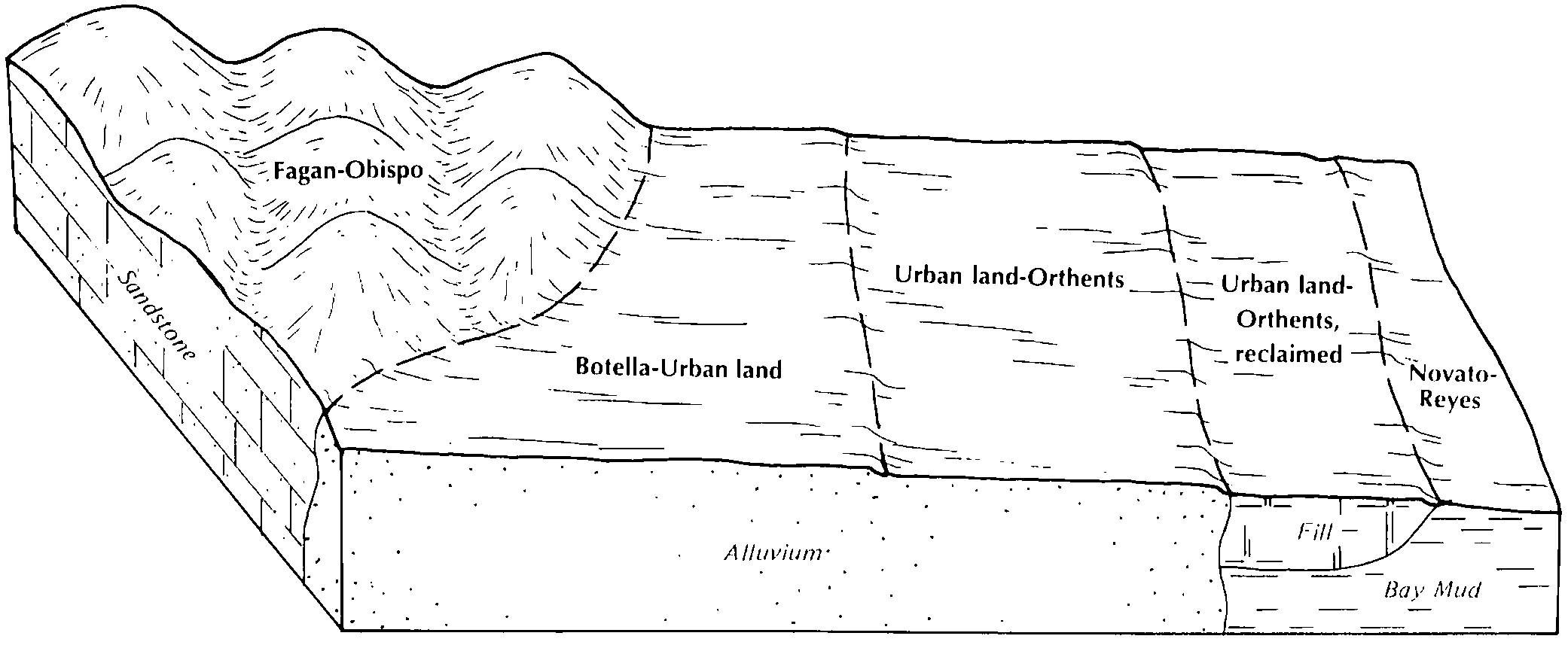
Orthents-Urban land complex, 0 to 2 percent slopes | 186 | 452 | 461930 | hhnz | ca067 | 1989 | 1:24000 |
Badland-Orthents complex, 30 to 75 percent slopes | 112 | 1047 | 463816 | hkmt | ca670 | 1977 | 1:24000 |
Orthents, 50 to 75 percent slopes | OAG | 991 | 457632 | hc6b | ca673 | 1974 | 1:24000 |
Rock outcrop-Orthents complex, 30 to 120 percent slopes | 123 | 1699 | 3059721 | 2xgvr | ca688 | 2008 | 1:24000 |
Urban land-Orthents, reclaimed complex, 0 to 2 percent slopes | 134 | 18094 | 455995 | h9hj | ca689 | 1985 | 1:24000 |
Orthents, cut and fill-Urban land complex, 5 to 75 percent slopes | 124 | 12081 | 455985 | h9h6 | ca689 | 1985 | 1:24000 |
Urban land-Orthents, cut and fill complex, 0 to 5 percent slopes | 132 | 9967 | 455993 | h9hg | ca689 | 1985 | 1:24000 |
Urban land-Orthents, cut and fill complex, 5 to 75 percent slopes | 133 | 9456 | 455994 | h9hh | ca689 | 1985 | 1:24000 |
Urban land-Orthents, smoothed complex, 5 to 50 percent slopes | 135 | 7682 | 455996 | h9hk | ca689 | 1985 | 1:24000 |
Orthents, cut and fill, 0 to 15 percent slopes | 121 | 4610 | 455982 | h9h3 | ca689 | 1985 | 1:24000 |
Orthents, cut and fill-Urban land complex, 0 to 5 percent slopes | 123 | 1615 | 455984 | h9h5 | ca689 | 1985 | 1:24000 |
Orthents, cut and fill, 15 to 75 percent slopes | 122 | 1197 | 455983 | h9h4 | ca689 | 1985 | 1:24000 |
Rock outcrop-Orthents complex, 30 to 75 percent slopes | 127 | 730 | 455988 | h9h9 | ca689 | 1985 | 1:24000 |
Los Robles-Trigo families-Orthents association, 30 to 60 percent slopes | 24 | 48063 | 465290 | hm5c | ca772 | 1981 | 1:24000 |
Orthents-Fluvents complex, dry, 0 to 15 percent slopes | 38 | 10900 | 465305 | hm5v | ca772 | 1981 | 1:24000 |
Orthents-Fluvents complex, 0 to 15 percent slopes | 39 | 4851 | 465306 | hm5w | ca772 | 1981 | 1:24000 |
Orthents | DAM | 123 | 95476 | 36bw | co626 | 1974 | 1:24000 |
Rock outcrop-Orthents complex, 40 to 90 percent slopes | 88 | 128356 | 502141 | jvj3 | co675 | 1986 | 1:24000 |
Pacolet-Orthents complex, 10 to 25 percent slopes, severely eroded | PgE3 | 495 | 125330 | 46dx | ga606 | 1973 | 1:20000 |
Orthents-urban land complex | 4946 | 2838 | 449417 | h2nb | ia013 | 2001 | 1:12000 |
Orthents, hilly | 5021 | 54 | 404700 | fl3v | ia051 | 1988 | 1:15840 |
Orthents, loamy, 5 to 14 percent slopes | 5040D | 699 | 405456 | flx7 | ia061 | 1983 | 1:15840 |
Orthents loamy, reclaimed, 2 to 9 percent slopes | 5043 | 237 | 405579 | fm16 | ia063 | 1989 | 1:15840 |
Orthents loamy, 1 to 5 percent slopes | 5040B | 699 | 407533 | fp27 | ia097 | 1988 | 1:15840 |
Orthents, hilly | 5021 | 81 | 408971 | fqkm | ia117 | 1991 | 1:15840 |
Aquents-orthents complex | 5090 | 175 | 447435 | h0ld | ia133 | 1994 | 1:12000 |
Orthents-urban land complex, 0 to 5 percent slopes | 4946 | 3477 | 412946 | fvpv | ia153 | 1993 | 1:12000 |
Udorthents, shaly substratum, 2 to 8 percent slopes | 6313 | 172 | 411833 | ftjy | ia179 | 1978 | 1:15840 |
Stookey-Timula-Orthents complex, 1 to 7 percent slopes | 816B | 2177 | 2378662 | 2kv61 | il001 | 1997 | 1:12000 |
Orthents, silty, undulating | 801B | 1415 | 2378661 | 2kv60 | il001 | 1997 | 1:12000 |
Stookey-Timula-Orthents complex, 7 to 15 percent slopes | 816D | 399 | 2378663 | 2kv62 | il001 | 1997 | 1:12000 |
Orthents, silty, undulating | 801B | 1493 | 603213 | n7ph | il003 | 2002 | 1:12000 |
Orthents, loamy, hilly | 802D | 1167 | 603214 | n7pj | il003 | 2002 | 1:12000 |
Orthents, loamy | 802 | 534 | 173883 | 5ty4 | il005 | 1981 | 1:12000 |
Orthents, loamy, undulating | 802B | 852 | 1407252 | 1j7c7 | il007 | 2006 | 1:12000 |
Orthents, loamy, 1 to 7 percent slopes | 802B | 1933 | 1862781 | 2ytdv | il011 | 2007 | 1:12000 |
Orthents, loamy, undulating | 802B | 392 | 901253 | z7tp | il015 | 2005 | 1:12000 |
Orthents, loamy, 1 to 7 percent slopes | 802B | 4287 | 243002 | 2ytdv | il019 | 1999 | 1:12000 |
Landfills | 830 | 115 | 243027 | 84wl | il019 | 1999 | 1:12000 |
Orthents, loamy, 1 to 7 percent slopes | 802B | 807 | 261726 | 2ytdv | il021 | 1999 | 1:12000 |
Landfills | 830 | 244 | 261747 | 8scg | il021 | 1999 | 1:12000 |
Orthents, loamy, 2 to 20 percent slopes | 802D | 79 | 1607476 | 1qyq2 | il023 | 2006 | 1:12000 |
Landfills | 830B | 10 | 1707309 | 1v9lh | il023 | 2006 | 1:12000 |
Orthents, silty, undulating | 801B | 267 | 2109193 | 28ssh | il025 | 1993 | 1:12000 |
Orthents, silty, undulating | 801 | 2120 | 174677 | 5vrr | il027 | 1992 | 1:15840 |
Landfill | 830 | 39 | 1547463 | 1ny85 | il029 | 2005 | 1:12000 |
Orthents, clayey, undulating | 805B | 54683 | 2108902 | 2ytf7 | il031 | 2008 | 1:12000 |
Urban land-Orthents, clayey, complex, nearly level | 534A | 31154 | 2518148 | 2qhr6 | il031 | 2008 | 1:12000 |
Urban land-Orthents, loamy, complex, nearly level | 392A | 26607 | 2518147 | 2qhr5 | il031 | 2008 | 1:12000 |
Orthents, loamy, 1 to 6 percent slopes | 802B | 12569 | 2108913 | 2ytf6 | il031 | 2008 | 1:12000 |
Orthents, clayey, nearly level | 805A | 5169 | 2518149 | 2qhr7 | il031 | 2008 | 1:12000 |
Orthents, loamy-Urban land-Watseka complex, 0 to 2 percent slopes | 2049A | 3672 | 2518168 | 2qhrv | il031 | 2008 | 1:12000 |
Orthents, loamy, nearly level | 802A | 3286 | 2518143 | 2qhr1 | il031 | 2008 | 1:12000 |
Orthents, clayey-Urban land-Ashkum complex, 0 to 2 percent slopes | 2232A | 2784 | 2558031 | 2qhrz | il031 | 2008 | 1:12000 |
Orthents, undulating, stony | 535B | 2648 | 2108903 | 28sh4 | il031 | 2008 | 1:12000 |
Orthents, loamy-Urban land-Darroch complex, 0 to 2 percent slopes | 2740A | 2510 | 2558032 | 2qhs0 | il031 | 2008 | 1:12000 |
Orthents, loamy-Urban land-Whitaker complex, 0 to 2 percent slopes | 2571A | 1855 | 2558038 | 2qhs6 | il031 | 2008 | 1:12000 |
Orthents, clayey, rolling | 805D | 1785 | 2518150 | 2qhr8 | il031 | 2008 | 1:12000 |
Urban land-Orthents, loamy, complex, gently sloping | 392B | 1724 | 2518152 | 2qhrb | il031 | 2008 | 1:12000 |
Orthents, loamy-skeletal, undulating | 807B | 1462 | 2518167 | 312zv | il031 | 2008 | 1:12000 |
Landfills | 830 | 1375 | 2108904 | 28sh5 | il031 | 2008 | 1:12000 |
Orthents, loamy-skeletal, nearly level | 807A | 721 | 2518166 | 312zt | il031 | 2008 | 1:12000 |
Urban land-Orthents, clayey, complex, gently sloping | 534B | 550 | 2518163 | 2qhrp | il031 | 2008 | 1:12000 |
Orthents, clayey, refuse substratum, rolling | 522D | 441 | 2558036 | 2qhs4 | il031 | 2008 | 1:12000 |
Orthents, clayey, refuse substratum, undulating | 522B | 370 | 2558035 | 2qhs3 | il031 | 2008 | 1:12000 |
Orthents, clayey, refuse substratum, steep | 522F | 368 | 2558037 | 2qhs5 | il031 | 2008 | 1:12000 |
Orthents, loamy, rolling | 802D | 339 | 2108912 | 28shf | il031 | 2008 | 1:12000 |
Orthents, rarely flooded | 7803C | 78 | 849137 | xhlj | il033 | 2004 | 1:12000 |
Orthents, loamy, nonacid, strongly sloping | 802E | 457 | 174863 | 5vyr | il035 | 1992 | 1:15840 |
Orthents, loamy, nonacid, gently sloping | 802B | 346 | 174862 | 5vyq | il035 | 1992 | 1:15840 |
Orthents, loamy, 1 to 6 percent slopes | 802B | 885 | 183939 | 2ytf6 | il037 | 1998 | 1:12000 |
Landfills | 830 | 122 | 183945 | 65dq | il037 | 1998 | 1:12000 |
Orthents, loamy, 1 to 7 percent slopes | 802B | 1123 | 1598515 | 2ytdv | il039 | 2005 | 1:12000 |
Orthents, loamy, 2 to 20 percent slopes | 802D | 321 | 1598517 | 1qnd2 | il039 | 2005 | 1:12000 |
Orthents, loamy, undulating | 802D | 236 | 1019442 | 136t7 | il041 | 2004 | 1:12000 |
Orthents, loamy-skeletal, acid, steep | 809F | 186 | 1019443 | 136t8 | il041 | 2004 | 1:12000 |
Orthents, clayey, undulating | 805B | 31336 | 183453 | 2ytf7 | il043 | 1998 | 1:12000 |
Orthents, loamy, 1 to 6 percent slopes | 802B | 5744 | 183451 | 2ytf6 | il043 | 1998 | 1:12000 |
Landfills | 830 | 470 | 183339 | 64s5 | il043 | 1998 | 1:12000 |
Orthents, loamy, rolling | 802D | 464 | 183452 | 64wt | il043 | 1998 | 1:12000 |
Orthents, stony, undulating | 535B | 323 | 183433 | 64w6 | il043 | 1998 | 1:12000 |
Orthents, silty, bedrock substratum-Pits, mine, complex, steep | 813F | 140 | 843582 | x9tb | il045 | 1997 | 1:12000 |
Orthents, loamy-skeletal, acid, steep | 809F | 85 | 843581 | x9t9 | il045 | 1997 | 1:12000 |
Orthents, loamy, 1 to 6 percent slopes | 802B | 251 | 198375 | 2ytf6 | il053 | 2001 | 1:12000 |
Orthents, clayey, undulating | 805B | 118 | 198376 | 2ytf7 | il053 | 2001 | 1:12000 |
Orthents, loamy, undulating | 802B | 3409 | 807133 | w2wk | il055 | 2005 | 1:12000 |
Orthents, loamy, hilly and very hilly | 802F | 207 | 807134 | w2wl | il055 | 2005 | 1:12000 |
Orthents, silty, undulating | 801B | 1386 | 615676 | nnnj | il057 | 1997 | 1:12000 |
Orthents, loamy | 802 | 569 | 211704 | 7395 | il059 | 1966 | 1:20000 |
Orthents, loamy, undulating | 802B | 57 | 2675042 | 2rtn8 | il059 | 1966 | 1:20000 |
Orthents, loamy, hilly and very hilly | 802F | 11 | 2675043 | 2rtn9 | il059 | 1966 | 1:20000 |
Orthents, loamy, 2 to 20 percent slopes | 802D | 28 | 2542256 | 2qxrz | il061 | 1968 | 1:15840 |
Orthents, loamy, 1 to 6 percent slopes | 802B | 2589 | 1384419 | 2ytf6 | il063 | 2005 | 1:12000 |
Orthents, loamy, rolling | 802D | 284 | 868753 | y509 | il063 | 2005 | 1:12000 |
Landfills | 830 | 273 | 1590335 | 1qcw4 | il063 | 2005 | 1:12000 |
Orthents, silty, moderately steep | 801E | 1250 | 175147 | 5w7x | il065 | 1982 | 1:15840 |
Orthents, loamy, undulating, rarely flooded | 7802B | 195 | 2604127 | 2r799 | il067 | 1993 | 1:15840 |
Orthents, loamy, hilly | 802E | 171 | 175219 | 5wb7 | il067 | 1993 | 1:15840 |
Orthents, loamy, undulating | 802B | 52 | 175218 | 5wb6 | il067 | 1993 | 1:15840 |
Orthents, silty, undulating | 801B | 108 | 713948 | ryxl | il069 | 2003 | 1:12000 |
Orthents, loamy, hilly | 802D | 4 | 713949 | ryxm | il069 | 2003 | 1:12000 |
Orthents, loamy, undulating | 802B | 137 | 1480525 | 1lplw | il071 | 2005 | 1:12000 |
Orthents, loamy, undulating | 802B | 1110 | 244829 | 86rq | il073 | 2001 | 1:12000 |
Orthents, loamy, 1 to 6 percent slopes | 802B | 448 | 175601 | 2ytf6 | il075 | 1980 | 1:15840 |
Orthents, clayey, undulating | 805B | 447 | 175602 | 2ytf7 | il075 | 1980 | 1:15840 |
Orthents, clayey, sloping | 805D | 2027 | 1540873 | 1nqdl | il077 | 2006 | 1:12000 |
Orthents, silty, undulating | 801B | 1591 | 1540357 | 1npvy | il077 | 2006 | 1:12000 |
Orthents, loamy, hilly and very hilly | 802F | 233 | 1540370 | 1npwc | il077 | 2006 | 1:12000 |
Orthents, clayey, sloping | 805C | 409 | 869388 | y5ns | il079 | 2005 | 1:12000 |
Orthents, loamy, undulating | 802B | 3292 | 1540491 | 1nq08 | il081 | 2005 | 1:12000 |
Orthents, loamy, hilly and very hilly | 802F | 560 | 1540492 | 1nq09 | il081 | 2005 | 1:12000 |
Orthents, loamy, hilly | 802E | 14 | 728619 | sg5v | il083 | 2002 | 1:12000 |
Dubuque-Orthents-Fayette complex, 12 to 25 percent slopes, pitted | 681E | 291 | 1949585 | 23fpv | il085 | 1990 | 1:12000 |
Orthents, silty, undulating | 801B | 279 | 1949599 | 23fq9 | il085 | 1990 | 1:12000 |
Orthents, loamy, hilly | 802E | 6 | 2108697 | 28s8h | il085 | 1990 | 1:12000 |
Orthents, loamy, hilly and very hilly | 802F | 468 | 1429077 | 1jz28 | il087 | 2005 | 1:12000 |
Orthents, loamy, hilly | 802D | 75 | 1603980 | 1qv29 | il087 | 2005 | 1:12000 |
Orthents, silty, undulating | 801B | 33 | 1604053 | 1qv4n | il087 | 2005 | 1:12000 |
Orthents, loamy, 1 to 6 percent slopes | 802B | 4152 | 271503 | 2ytf6 | il089 | 2000 | 1:12000 |
Orthents, clayey, undulating | 805B | 303 | 271566 | 2ytf7 | il089 | 2000 | 1:12000 |
Orthents, loamy, rolling | 802D | 231 | 200922 | 6r2c | il089 | 2000 | 1:12000 |
Landfills | 830 | 71 | 271592 | 93m1 | il089 | 2000 | 1:12000 |
Orthents, loamy, 1 to 6 percent slopes | 802B | 1791 | 991325 | 2ytf6 | il091 | 2003 | 1:12000 |
Orthents, clayey, undulating | 805B | 383 | 991328 | 2ytf7 | il091 | 2003 | 1:12000 |
Orthents, loamy, hilly | 802F | 332 | 991327 | 128k9 | il091 | 2003 | 1:12000 |
Landfills | 830 | 164 | 991329 | 128kc | il091 | 2003 | 1:12000 |
Orthents, loamy, 1 to 6 percent slopes | 802B | 618 | 1715670 | 2ytf6 | il093 | 2007 | 1:12000 |
Orthents, silty, undulating | 801B | 3144 | 681001 | qvms | il095 | 2002 | 1:12000 |
Orthents, loamy, undulating | 802B | 221 | 681011 | qvn3 | il095 | 2002 | 1:12000 |
Orthents, loamy, 1 to 6 percent slopes | 802B | 6037 | 777743 | 2ytf6 | il097 | 2003 | 1:12000 |
Orthents, clayey, undulating | 805B | 4100 | 777744 | 2ytf7 | il097 | 2003 | 1:12000 |
Landfills | 830 | 1206 | 807322 | w32n | il097 | 2003 | 1:12000 |
Orthents, loamy, 1 to 6 percent slopes | 802B | 4352 | 1427825 | 2ytf6 | il099 | 2006 | 1:12000 |
Orthents, acid, undulating and rolling | 804D | 1217 | 1427827 | 1jxry | il099 | 2006 | 1:12000 |
Orthents, loamy, rolling | 802D | 1022 | 1427826 | 1jxrx | il099 | 2006 | 1:12000 |
Orthents, clayey, undulating | 805B | 867 | 1427829 | 2ytf7 | il099 | 2006 | 1:12000 |
Orthents, acid, steep | 804G | 336 | 1427828 | 1jxrz | il099 | 2006 | 1:12000 |
Landfills | 830 | 270 | 1427830 | 1jxs1 | il099 | 2006 | 1:12000 |
Orthents, loamy, undulating | 802B | 343 | 1651758 | 1sfsj | il101 | 1952 | 1:42240 |
Orthents, loamy, rolling | 802D | 68 | 1651759 | 1sfsk | il101 | 1952 | 1:42240 |
Orthents, loamy, nearly level | 802A | 2135 | 921425 | zxtd | il103 | 2004 | 1:12000 |
Orthents, clayey, undulating | 805B | 1455 | 177002 | 2ytf7 | il105 | 1991 | 1:15840 |
Orthents, loamy, 1 to 6 percent slopes | 802B | 1234 | 2648883 | 2ytf6 | il105 | 1991 | 1:15840 |
Landfills | 830 | 718 | 2648882 | 2rltv | il105 | 1991 | 1:15840 |
Orthents, loamy, 1 to 7 percent slopes | 802B | 622 | 1596094 | 2ytdv | il107 | 2006 | 1:12000 |
Orthents loamy, hilly | 802E | 180 | 1596095 | 1qkvy | il107 | 2006 | 1:12000 |
Landfills | 830 | 110 | 1596102 | 1qkw5 | il107 | 2006 | 1:12000 |
Orthents loamy, undulating | 802B | 1225 | 634207 | p8y9 | il109 | 2002 | 1:12000 |
Orthents loamy, hilly | 802E | 1143 | 634254 | p8zt | il109 | 2002 | 1:12000 |
Orthents, loamy, undulating | 802B | 1221 | 182783 | 6467 | il111 | 1997 | 1:12000 |
Orthents, loamy, 1 to 7 percent slopes | 802B | 2298 | 199139 | 2ytdv | il113 | 2000 | 1:12000 |
Orthents, loamy, 1 to 7 percent slopes | 802B | 2039 | 1913974 | 2ytdv | il115 | 2007 | 1:12000 |
Orthents, loamy, rolling | 802D | 1165 | 1913975 | 227n4 | il115 | 2007 | 1:12000 |
Orthents, loamy, undulating, rarely flooded | 7802B | 334 | 1913991 | 227nn | il115 | 2007 | 1:12000 |
Orthents, loamy, undulating | 802B | 774 | 199257 | 6pbn | il117 | 1999 | 1:12000 |
Orthents, loamy, hilly | 802E | 674 | 199203 | 6p8x | il117 | 1999 | 1:12000 |
Landfills | 830 | 3 | 199258 | 6pbp | il117 | 1999 | 1:12000 |
Winfield-Orthents-Urban land complex, 2 to 8 percent slopes | 2477B | 8063 | 200832 | 6qzg | il119 | 2001 | 1:12000 |
Orthents, loamy, undulating | 802B | 3042 | 198918 | 6nzq | il119 | 2001 | 1:12000 |
Orthents, loamy, hilly | 802D | 2020 | 198919 | 6nzr | il119 | 2001 | 1:12000 |
Orthents, silty, steep | 801D | 1586 | 198917 | 6nzp | il119 | 2001 | 1:12000 |
Menfro-Orthents-Urban land complex, 8 to 15 percent slopes | 2079D | 1545 | 200827 | 6qz9 | il119 | 2001 | 1:12000 |
Orthents, silty, undulating | 801B | 964 | 198916 | 6nzn | il119 | 2001 | 1:12000 |
Edwardsville-Orthents-Urban land complex, 1 to 4 percent slopes | 2384B | 500 | 200831 | 6qzf | il119 | 2001 | 1:12000 |
Oconee-Orthents-Urban land complex, 2 to 5 percent slopes | 2113B | 456 | 200833 | 6qzh | il119 | 2001 | 1:12000 |
Colp-Orthents-Urban land complex, 2 to 5 percent slopes, rarely flooded | 2122B | 382 | 200829 | 6qzc | il119 | 2001 | 1:12000 |
Orthents, silty, undulating | 801B | 1792 | 2027398 | 261ny | il121 | 2008 | 1:12000 |
Orthents, loamy, 1 to 7 percent slopes | 802B | 516 | 182236 | 2ytdv | il123 | 1997 | 1:15840 |
Orthents, loamy, hilly | 802D | 675 | 808045 | w3tz | il127 | 2004 | 1:12000 |
Orthents, silty, undulating | 801B | 400 | 808044 | w3ty | il127 | 2004 | 1:12000 |
Orthents, loamy, hilly | 802E | 11 | 1408317 | 1j8gl | il129 | 2005 | 1:12000 |
Orthents, loamy, undulating | 802B | 5 | 245009 | 86yj | il131 | 2000 | 1:12000 |
Fluvaquents-Orthents complex, frequently flooded, long duration | 3847L | 2957 | 184081 | 65k3 | il133 | 1998 | 1:12000 |
Orthents, silty, steep | 801D | 343 | 184123 | 65lg | il133 | 1998 | 1:12000 |
Orthents, loamy, steep | 802D | 274 | 184124 | 65lh | il133 | 1998 | 1:12000 |
Orthents, loamy, undulating | 802B | 750 | 1721561 | 1vsf7 | il135 | 2007 | 1:12000 |
Orthents, loamy, hilly | 802E | 194 | 1721562 | 1vsf8 | il135 | 2007 | 1:12000 |
Landfills | 830 | 116 | 1721563 | 1vsf9 | il135 | 2007 | 1:12000 |
Orthents, loamy, 2 to 20 percent slopes | 802D | 9 | 2542159 | 2qvjj | il137 | 1984 | 1:15840 |
Orthents, loamy, 2 to 20 percent slopes | 802D | 106 | 780655 | v6bf | il139 | 1999 | 1:12000 |
Landfills | 830 | 31 | 246551 | 88k8 | il139 | 1999 | 1:12000 |
Orthents, loamy, nearly level | 802A | 1325 | 1144046 | 17dgq | il141 | 2005 | 1:12000 |
Orthents, loamy, 1 to 7 percent slopes | 802B | 6241 | 209016 | 2ytdv | il143 | 1986 | 1:15840 |
Orthents, loamy, undulating | 802B | 1311 | 1405944 | 1j601 | il145 | 2005 | 1:12000 |
Orthents, loamy, 1 to 7 percent slopes | 802B | 403 | 1910917 | 2ytdv | il147 | 2009 | 1:12000 |
Orthents, silty, undulating | 801B | 44 | 608161 | ndv3 | il151 | 2003 | 1:12000 |
Orthents, loamy, hilly | 802D | 34 | 608162 | ndv4 | il151 | 2003 | 1:12000 |
Orthents, silty, undulating | 801B | 605 | 748928 | t49z | il153 | 2004 | 1:12000 |
Orthents, loamy, hilly | 802D | 395 | 748929 | t4b0 | il153 | 2004 | 1:12000 |
Orthents, loamy, 1 to 7 percent slopes | 802B | 690 | 172884 | 2ytdv | il155 | 1987 | 1:15840 |
Orthents, loamy, undulating, rarely flooded | 7802B | 30 | 2650849 | 2r21w | il155 | 1987 | 1:15840 |
Orthents, loamy, undulating | 802B | 3389 | 200508 | 6qn0 | il157 | 2001 | 1:12000 |
Fluvaquents-Orthents complex, frequently flooded, long duration | 3847L | 2735 | 200555 | 6qpj | il157 | 2001 | 1:12000 |
Orthents, loamy, hilly | 802D | 1212 | 200509 | 6qn1 | il157 | 2001 | 1:12000 |
Orthents loamy, 2 to 20 percent slopes | 802D | 56 | 2027024 | 2618w | il159 | 1967 | 1:12000 |
Orthents, loamy, undulating | 802B | 8117 | 198754 | 6ntf | il161 | 2002 | 1:12000 |
Winfield-Orthents-Urban land complex, 2 to 8 percent slopes | 2477B | 5079 | 182912 | 6qzg | il163 | 1997 | 1:12000 |
Edwardsville-Orthents-Urban land complex, 1 to 4 percent slopes | 2384B | 2842 | 182905 | 6qzf | il163 | 1997 | 1:12000 |
Orthents, loamy, steep | 802D | 2465 | 183124 | 64k7 | il163 | 1997 | 1:12000 |
Orthents, loamy, undulating | 802B | 1240 | 183123 | 64k6 | il163 | 1997 | 1:12000 |
Fluvaquents-Orthents complex, frequently flooded, long duration | 3847L | 1070 | 183002 | 64f9 | il163 | 1997 | 1:12000 |
Orthents, silty, steep | 801D | 1041 | 183120 | 64k3 | il163 | 1997 | 1:12000 |
Menfro-Orthents-Urban land complex, 8 to 15 percent slopes | 2079D | 744 | 182902 | 6qz9 | il163 | 1997 | 1:12000 |
Orthents, silty, undulating | 801B | 514 | 183118 | 64k1 | il163 | 1997 | 1:12000 |
Menfro-Orthents-Urban land complex, 15 to 25 percent slopes | 2079E | 500 | 182903 | 3019y | il163 | 1997 | 1:12000 |
Orthents, silty, acid substratum, rolling | 826D | 323 | 183142 | 64kt | il163 | 1997 | 1:12000 |
Orthents, 15 to 60 percent slopes | 803F | 5018 | 178903 | 6052 | il165 | 1974 | 1:15840 |
Orthents, 5 to 15 percent slopes | 803C | 3555 | 178902 | 6051 | il165 | 1974 | 1:15840 |
Orthents, loamy, undulating | 802B | 1629 | 2796146 | 64k6 | il165 | 1974 | 1:15840 |
Orthents, acid, 15 to 60 percent slopes | 804F | 1282 | 178904 | 6053 | il165 | 1974 | 1:15840 |
Orthents, silty, rolling | 801C | 442 | 199330 | 6pf0 | il167 | 1999 | 1:12000 |
Landfills | 830 | 50 | 199399 | 6ph7 | il167 | 1999 | 1:12000 |
Orthents loamy, undulating | 802B | 171 | 202108 | 6s9m | il169 | 2000 | 1:12000 |
Orthents loamy, hilly | 802E | 49 | 202225 | 6sfd | il169 | 2000 | 1:12000 |
Orthents, loamy, 2 to 20 percent slopes | 802D | 10 | 2542093 | 2qrcy | il171 | 1984 | 1:12000 |
Orthents, loamy, 7 to 20 percent slopes | 802D | 214 | 179042 | 609k | il173 | 1990 | 1:15840 |
Orthents, loamy, undulating | 802B | 458 | 1674965 | 1t6y4 | il177 | 2006 | 1:12000 |
Orthents, loamy, 2 to 20 percent slopes | 802D | 5476 | 179427 | 60pz | il179 | 1991 | 1:15840 |
Landfills | 830 | 328 | 2508819 | 2q7ys | il179 | 1991 | 1:15840 |
Orthents, loamy, hilly | 802D | 1342 | 199523 | 6pm7 | il181 | 2001 | 1:12000 |
Orthents, silty, undulating | 801B | 442 | 199447 | 6pjs | il181 | 2001 | 1:12000 |
Orthents, loamy, 1 to 6 percent slopes | 802B | 2200 | 1613238 | 2ytf6 | il183 | 2006 | 1:12000 |
Orthents, loamy, steep | 802F | 414 | 1613239 | 1r4pz | il183 | 2006 | 1:12000 |
Orthents loamy, 2 to 20 percent slopes | 802D | 32 | 2857693 | 2618w | il185 | 1962 | 1:20000 |
Orthents, loamy, undulating | 802B | 318 | 244922 | 86vq | il187 | 2002 | 1:12000 |
Orthents, silty, undulating | 801B | 714 | 1528957 | 1nb06 | il189 | 2006 | 1:12000 |
Orthents, loamy, undulating | 802B | 796 | 1543927 | 1ntl3 | il193 | 2006 | 1:12000 |
Orthents, loamy, undulating | 802B | 1794 | 793094 | vm8p | il195 | 2003 | 1:12000 |
Pits, Quarries-Orthents complex | 869 | 194 | 793097 | vm8s | il195 | 2003 | 1:12000 |
Orthents, loamy, 1 to 6 percent slopes | 802B | 7191 | 618742 | 2ytf6 | il197 | 2002 | 1:12000 |
Orthents, clayey, undulating | 805B | 728 | 618741 | 2ytf7 | il197 | 2002 | 1:12000 |
Orthents, loamy, rolling | 802D | 672 | 618743 | nrvg | il197 | 2002 | 1:12000 |
Landfills | 830 | 170 | 618740 | nrvc | il197 | 2002 | 1:12000 |
Orthents, loamy, undulating | 802B | 3184 | 1478212 | 1lm68 | il199 | 2007 | 1:12000 |
Orthents, loamy, hilly and very hilly | 802F | 603 | 1670767 | 1t2kq | il199 | 2007 | 1:12000 |
Orthents, loamy, undulating | 802B | 3689 | 174200 | 5v8c | il201 | 1997 | 1:12000 |
Orthents, loamy, rolling | 802D | 937 | 2216073 | 2dd07 | il203 | 2008 | 1:12000 |
Orthents, loamy, 1 to 7 percent slopes | 802B | 8 | 2216074 | 2ytdv | il203 | 2008 | 1:12000 |
Orthents, earthen dam | Omz | 87 | 617092 | nq46 | in005 | 2002 | 1:12000 |
Orthents, earthen dam | Omz | 42 | 1598982 | 1qnw2 | in013 | 1985 | 1:15840 |
Orthents, earthen dam | Omz | 5 | 1454583 | 1ktm1 | in015 | 1987 | 1:15840 |
Orthents, earthen dam | Omz | 41 | 1710204 | 1vdlw | in027 | 1969 | 1:20000 |
Orthents, earthen dam | Omz | 16 | 1725626 | 1vxnc | in029 | 1979 | 1:15840 |
Orthents, earthen dam | Omz | 8 | 1592396 | 1qg0m | in031 | 1980 | 1:15840 |
Gilpin-Orthents complex, 12 to 25 percent slopes | GuD | 367 | 535629 | kzcc | in037 | 1978 | 1:15840 |
Orthents, earthen dam | Omz | 36 | 1675886 | 1t7wv | in037 | 1978 | 1:15840 |
Orthents, earthen dam | Omz | 40 | 713623 | ryl3 | in047 | 1984 | 1:15840 |
Orthents | Or | 854 | 3186637 | 5dbc | in057 | 1976 | 1:15840 |