| Orrville silt loam, frequently flooded | Or | 892 | 1600667 | 1qqmf | in029 | 1979 | 1:15840 |
Orrville silt loam, frequently flooded | Or | 9516 | 162406 | 5fzx | in031 | 1980 | 1:15840 |
Orrville silt loam, frequently flooded | Or | 39 | 1600559 | 1qqhy | in115 | 1979 | 1:15840 |
Orrville loam, 0 to 3 percent slopes, frequently flooded | OrA | 1355 | 1727470 | 2w1vy | ky011 | 2006 | 1:12000 |
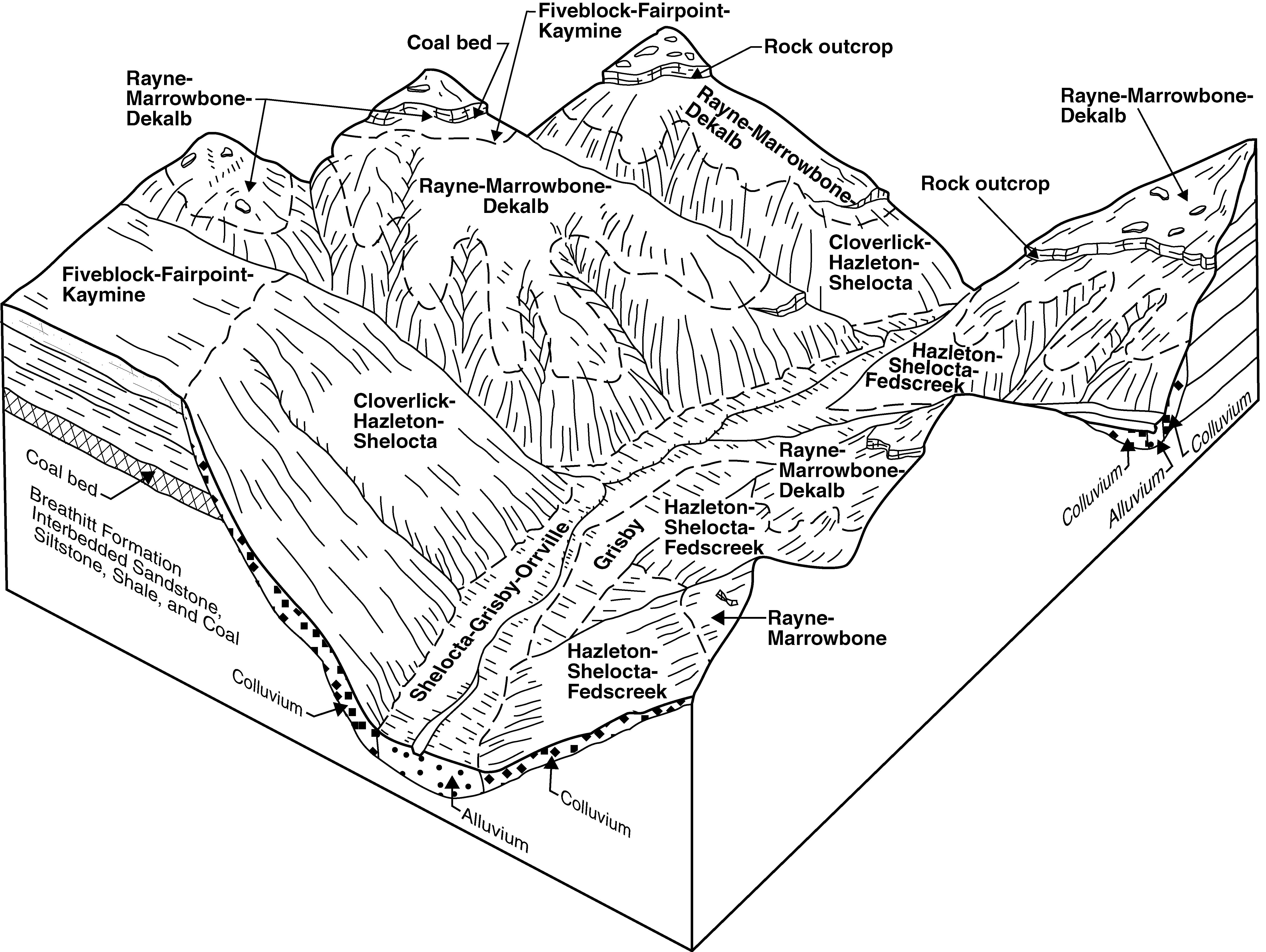
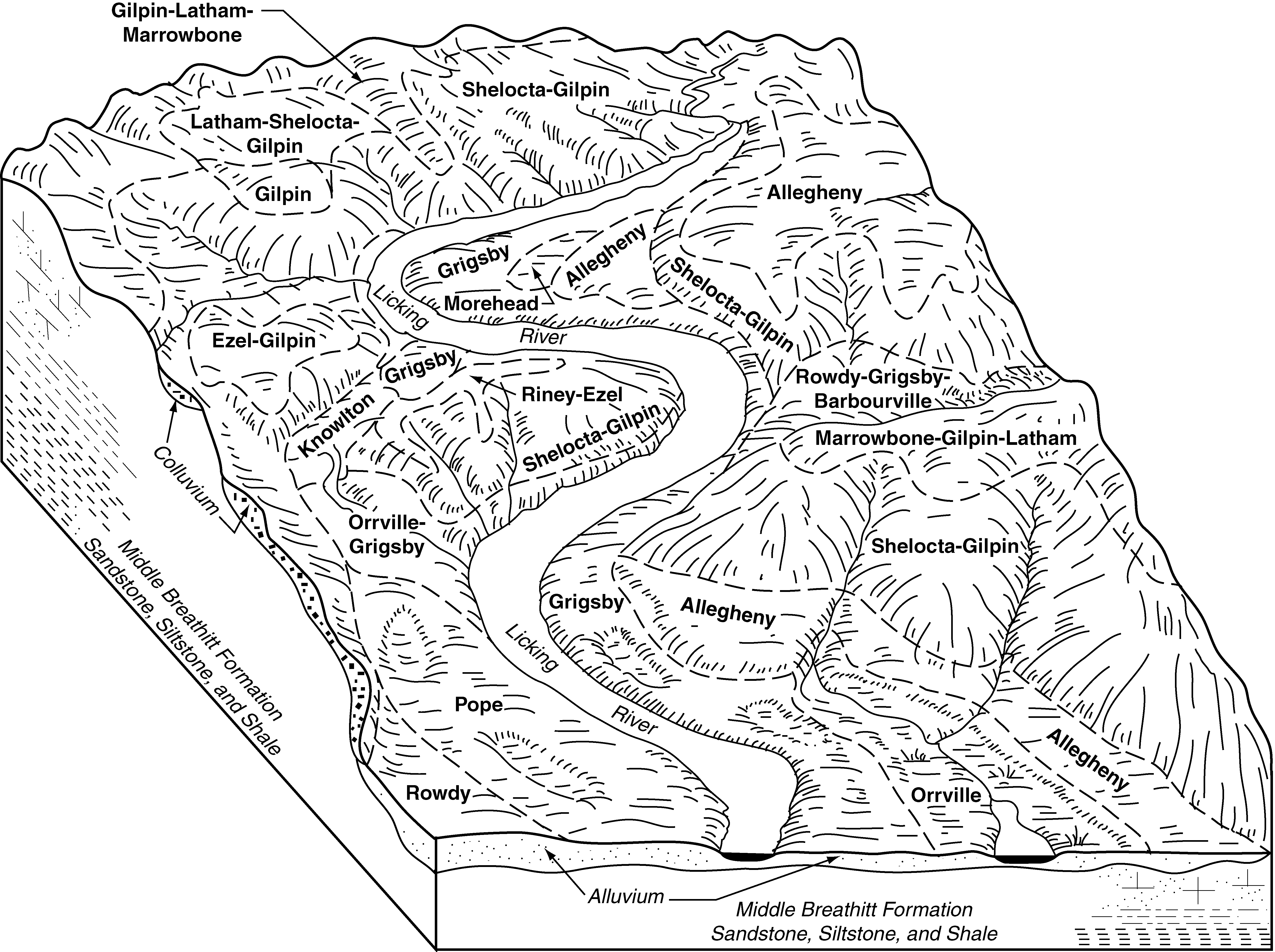
Shelocta-Grigsby-Orrville complex, 2 to 15 percent slopes | SoC | 4145 | 1884663 | 2184l | ky063 | 2007 | 1:12000 |
Orrville loam, 0 to 3 percent slopes, occasionally flooded | Or | 414 | 1884653 | 2w1vx | ky063 | 2007 | 1:12000 |
Grigsby-Orrville variant complex, 0 to 3 percent slopes, frequently flooded | Gv | 2891 | 550708 | lh1s | ky623 | 1985 | 1:20000 |
Grigsby-Orrville complex, frequently flooded | Gu | 4741 | 550832 | lh5s | ky634 | 1989 | 1:20000 |
Orrville silt loam, occasionally flooded | Or | 280 | 550846 | lh67 | ky634 | 1989 | 1:20000 |
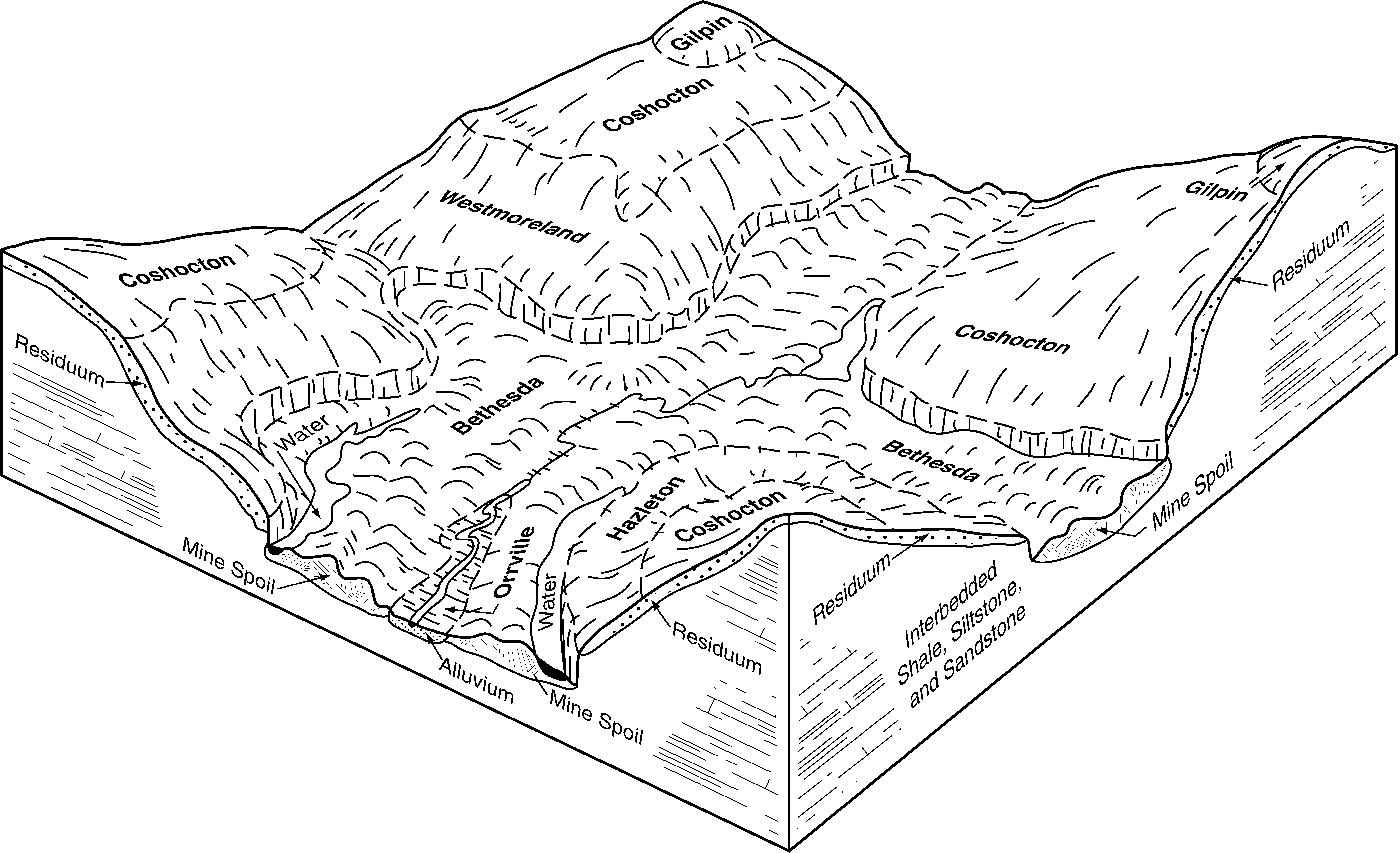
Shelocta-Grigsby-Orrville complex, 2 to 15 percent slopes | SgC | 11633 | 550914 | lh8f | ky640 | 1996 | 1:24000 |
Orrville silt loam, 0 to 3 percent slopes, frequently flooded | Or | 922 | 550910 | 2w1vz | ky640 | 1996 | 1:24000 |
Orrville-Grigsby complex, 0 to 3 percent slopes, frequently flooded | Oy | 1676 | 550949 | lh9k | ky641 | 1994 | 1:24000 |
Orrville loam, 0 to 3 percent slopes, frequently flooded | Or | 442 | 550948 | 2w1vy | ky641 | 1994 | 1:24000 |
Orrville silt loam, occasionally flooded | Or | 487 | 1592639 | 1qg8g | oh005 | 1976 | 1:15840 |
Orrville silt loam, frequently flooded | Om | 13 | 1592623 | 1qg7y | oh005 | 1976 | 1:15840 |
Orrville silt loam, 0 to 2 percent slopes, frequently flooded | OrA | 512 | 298853 | b0zf | oh007 | 2001 | 1:12000 |
Orrville silt loam, 0 to 3 percent slopes, frequently flooded | Orr1AF | 513 | 2441853 | 2myyg | oh009 | 1981 | 1:15840 |
Orrville silt loam, 0 to 3 percent slopes, occasionally flooded | Or | 5445 | 537998 | 2w1vw | oh019 | 1981 | 1:15840 |
Orrville silt loam, 0 to 2 percent slopes, occasionally flooded | OvA | 132 | 1670697 | 1t2hg | oh019 | 1981 | 1:15840 |
Orrville silt loam, 0 to 3 percent slopes, occasionally flooded | OrA | 4155 | 633758 | 2w1vw | oh029 | 2005 | 1:12000 |
Orrville silt loam, 0 to 3 percent slopes, occasionally flooded | Or | 11078 | 536677 | 2w1vw | oh031 | 1996 | 1:15840 |
Orrville silt loam, frequently flooded | Or | 2135 | 287256 | 9mxb | oh035 | 1978 | 1:15840 |
Orrville silt loam, bedrock substratum, 0 to 2 percent slopes, occasionally flooded | OpA | 2406 | 172168 | 5s4t | oh043 | 1998 | 1:12000 |
Orrville silt loam, bedrock substratum, 0 to 2 percent slopes, frequently flooded | OrA | 385 | 172169 | 5s4v | oh043 | 1998 | 1:12000 |
Orrville silt loam, frequently flooded | On | 123 | 1653923 | 1sj1c | oh043 | 1998 | 1:12000 |
Orrville silt loam, 0 to 3 percent slopes, frequently flooded | Orr1AF | 683 | 2450465 | 2n7x8 | oh053 | 1988 | 1:15840 |
Orrville silt loam, frequently flooded | Or | 6117 | 287576 | 9n7n | oh055 | 1979 | 1:15840 |
Orrville silt loam, 0 to 3 percent slopes, occasionally flooded | Or | 128 | 536943 | 2w1vw | oh059 | 1998 | 1:15840 |
Orrville silt loam, 0 to 3 percent slopes, occasionally flooded | Or | 8808 | 536767 | 2w1vw | oh067 | 1993 | 1:15840 |
Orrville silt loam, 0 to 3 percent slopes, frequently flooded | Ou | 19 | 1420691 | 2w1vz | oh071 | 1973 | 1:15840 |
Orrville silt loam, 0 to 3 percent slopes, frequently flooded | Orr1AF | 4823 | 2450626 | 2n82g | oh073 | 1986 | 1:15840 |
Orrville silt loam, 0 to 3 percent slopes, frequently flooded | Or | 1793 | 1398089 | 2w1vz | oh073 | 1986 | 1:15840 |
Orrville silt loam, 0 to 3 percent slopes, occasionally flooded | Or | 13585 | 286925 | 2w1vw | oh075 | 1989 | 1:15840 |
Orrville silt loam, frequently flooded | Or | 4190 | 167989 | 5mt0 | oh077 | 1988 | 1:15840 |
Orrville silt loam, bedrock substratum, 0 to 2 percent slopes, frequently flooded | OpA | 84 | 1605982 | 1qx4w | oh077 | 1988 | 1:15840 |
Orrville silt loam | Om | 45 | 1605999 | 1qx5f | oh077 | 1988 | 1:15840 |
Orrville silt loam, bedrock substratum, 0 to 2 percent slopes, occasionally flooded | OnA | 1 | 1605981 | 1qx4v | oh077 | 1988 | 1:15840 |
Orrville silt loam, 0 to 3 percent slopes, frequently flooded | Or | 4295 | 536027 | 2w1vz | oh079 | 1981 | 1:15840 |
Orrville silt loam, 0 to 3 percent slopes, occasionally flooded | Or | 727 | 536106 | 2w1vw | oh081 | 1987 | 1:15840 |
Orrville silt loam, 0 to 3 percent slopes, occasionally flooded | Or | 8224 | 613757 | 2w1vw | oh083 | 1983 | 1:15840 |
Orrville silt loam | Or | 3792 | 286828 | 9mgj | oh085 | 1976 | 1:15840 |
Orrville silt loam, 0 to 3 percent slopes, frequently flooded | Orr1AF | 94 | 2451105 | 2n8kx | oh087 | 1989 | 1:15840 |
Orrville silt loam, 0 to 3 percent slopes, occasionally flooded | Or | 6965 | 171067 | 2w1vw | oh089 | 1986 | 1:15840 |
Orrville silt loam | Or | 7704 | 287800 | 9ngw | oh093 | 1972 | 1:15840 |
Orrville silt loam | Ov | 3294 | 816802 | wdyg | oh099 | 1966 | 1:15840 |
Orrville silt loam | Or | 9447 | 288374 | 9p2d | oh103 | 1974 | 1:15840 |
Orrville silt loam, bedrock substratum | Os | 686 | 288375 | 9p2f | oh103 | 1974 | 1:15840 |
Orrville silt loam, frequently flooded | Ou | 30 | 1541434 | 1nqzp | oh103 | 1974 | 1:15840 |
Orrville silt loam, 0 to 3 percent slopes, frequently flooded | Orr1AF | 1630 | 2451283 | 2n8rn | oh105 | 1991 | 1:15840 |
Orrville silt loam, 0 to 3 percent slopes, frequently flooded | Orr1AF | 178 | 2474485 | 2p1x3 | oh127 | 1984 | 1:15840 |
Orrville silt loam, 0 to 3 percent slopes, frequently flooded | Or | 439 | 537686 | 2w1vz | oh131 | 1984 | 1:15840 |
Orrville silt loam | Or | 3280 | 288482 | 9p5w | oh133 | 1973 | 1:15840 |
Orrville silt loam, frequently flooded | Ov | 177 | 1717852 | 1vnkl | oh133 | 1973 | 1:15840 |
Orrville silt loam, 0 to 3 percent slopes, frequently flooded | Or | 50 | 170933 | 2w1vz | oh141 | 1997 | 1:15840 |
Orrville silt loam, occasionally flooded | Ot | 389 | 1595480 | 1qk73 | oh151 | 1967 | 1:15840 |
Orrville silt loam, 0 to 3 percent slopes, occasionally flooded | OrA | 82 | 1595516 | 2w1vw | oh151 | 1967 | 1:15840 |
Orrville silt loam | Or | 1550 | 825383 | wpw8 | oh153 | 1969 | 1:20000 |
Orrville silt loam, frequently flooded | Or | 8020 | 287113 | 9mrq | oh155 | 1986 | 1:15840 |
Orrville silt loam, 0 to 3 percent slopes, occasionally flooded | Or | 11080 | 536328 | 2w1vw | oh157 | 1981 | 1:15840 |
Orrville silt loam, 0 to 3 percent slopes, frequently flooded | Or | 296 | 536415 | 2w1vz | oh163 | 1998 | 1:15840 |
Orrville silt loam, occasionally flooded | Or | 11914 | 287215 | 9mw0 | oh169 | 1981 | 1:15840 |
Orrville silt loam, frequently flooded | Or | 55 | 1612217 | 1r3n0 | pa085 | 1967 | 1:20000 |
Orrville silt loam | Ow | 9446 | 297151 | 9z6j | pa117 | 1973 | 1:20000 |
Lobdell-Orrville complex, 0 to 3 percent slopes, occasionally flooded | 21A | 2874 | 521723 | khws | va105 | 1997 | 1:24000 |
Holly-Orrville complex, 0 to 3 percent slopes, occasionally flooded | 30A | 582 | 2514803 | 2qdbd | va163 | 2010 | 1:24000 |
Lobdell-Orrville complex, 0 to 3 percent slopes, occasionally flooded | 36A | 4664 | 1671130 | 1t2yf | va167 | 2006 | 1:24000 |
Lobdell-Orrville complex, 0 to 3 percent slopes, occasionally flooded | 28A | 5736 | 778070 | v3n1 | va169 | 2003 | 1:24000 |
Orrville-Lobdell silt loams, 0 to 3 percent slopes, occasionally flooded | 63A | 440 | 2508601 | 2q7rh | va195 | 2010 | 1:24000 |
Holly-Orrville silt loams, 0 to 3 percent slopes, occasionally flooded | 36A | 248 | 2508561 | 2q7qb | va195 | 2010 | 1:24000 |
Orrville loam, 0 to 3 percent slopes, occasionally flooded | Or | 878 | 553371 | 2w1vx | wv043 | 2005 | 1:24000 |
Orrville loam | Or | 1140 | 514199 | k822 | wv071 | 1988 | 1:20000 |
Orrville silt loam | Or | 2093 | 515432 | k9bv | wv075 | 1992 | 1:24000 |
Orrville-Holly silt loams | Oh | 3034 | 515494 | k9dv | wv097 | 1981 | 1:20000 |
Orrville-Lobdell complex | Ol | 3375 | 2516658 | 261cg | wv713 | | 1:24000 |
Orrville silt loam | Oe | 1437 | 2516657 | 261cf | wv713 | | 1:24000 |
Urban land-Orrville-Lobdell complex | Uo | 833 | 2516611 | k9zx | wv713 | | 1:24000 |