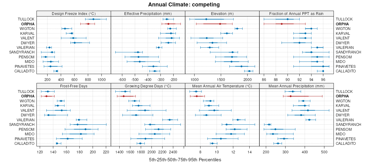
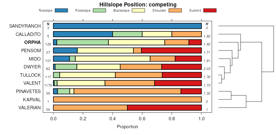
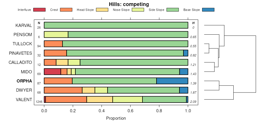
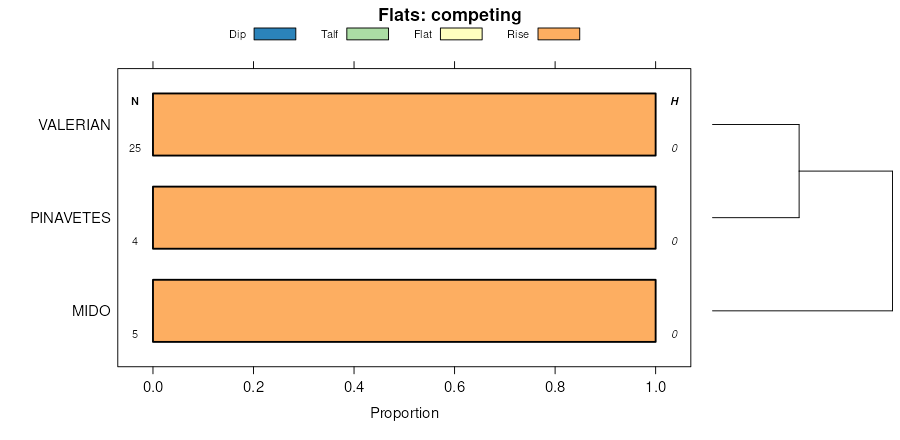
| Orpha-Niobrara loamy fine sands, 9 to 30 percent slopes | 4717 | 4290 | 100422 | 3chf | ne031 | 1995 | 1:24000 |
Orpha-Rock outcrop complex, 30 to 60 percent slopes | 4718 | 4228 | 100423 | 3chg | ne031 | 1995 | 1:24000 |
Orpha loamy fine sand, 3 to 9 percent slopes | 4713 | 1337 | 100421 | 3chd | ne031 | 1995 | 1:24000 |
Orpha-Niobrara complex, 9 to 30 percent slopes | 4716 | 106 | 2217559 | 2dfk5 | ne045 | 1973 | 1:20000 |
Orpha loamy fine sand, 3 to 9 percent slopes | 4713 | 12 | 2217558 | 2dfk4 | ne045 | 1973 | 1:20000 |
Orpha-Niobrara complex, 9 to 30 percent slopes | 4716 | 18856 | 100626 | 3cq0 | ne161 | 1992 | 1:20000 |
Orpha-Rock outcrop complex, 30 to 60 percent slopes | 4718 | 13076 | 100627 | 3cq1 | ne161 | 1992 | 1:20000 |
Orpha loamy fine sand, 3 to 9 percent slopes | 4713 | 2875 | 100625 | 3cpz | ne161 | 1992 | 1:20000 |
Orpha-Niobrara loamy fine sands, 9 to 30 percent slopes | 4717 | 778 | 2219851 | 2dhy3 | ne161 | 1992 | 1:20000 |
Orpha loamy sand, moist, 6 to 10 percent slopes | P304C | 54 | 2745939 | 2rvg0 | wy011 | 1978 | 1:24000 |
Dailey-Orpha, moist, loamy sands, 0 to 6 percent slopes | 119 | 10637 | 349551 | cqqv | wy027 | 1993 | 1:24000 |
Orpha, moist-Dailey loamy fine sands, 6 to 15 percent slopes | 168 | 8209 | 349649 | cqv0 | wy027 | 1993 | 1:24000 |
Orpha-Dwyer fine sands, 0 to 6 percent slopes | 169 | 3573 | 349651 | cqv2 | wy027 | 1993 | 1:24000 |
Orpha-Dwyer-Taluce complex, 6 to 15 percent slopes | 170 | 3418 | 349653 | cqv4 | wy027 | 1993 | 1:24000 |
Orpha fine sand, 0 to 15 percent slopes | 194 | 4174 | 104550 | 3hsl | wy031 | 1998 | 1:24000 |
Orpha-Tullock loamy fine sands, 6 to 20 percent slopes | 195 | 2389 | 104551 | 3hsm | wy031 | 1998 | 1:24000 |
Embry-Orpha complex, 3 to 15 percent slopes | 133 | 413 | 361687 | d4cb | wy045 | 1984 | 1:24000 |
Orpha-Dwyer fine sands, 0 to 6 percent slopes | 160 | 134 | 1614845 | 1r6cs | wy045 | 1984 | 1:24000 |
Embry-Orpha complex, 3 to 15 percent slopes | 139 | 6322 | 349824 | cr0n | wy605 | 1995 | 1:24000 |
Orpha-Tullock loamy sands, 6 to 30 percent slopes | 188 | 3288 | 349884 | cr2l | wy605 | 1995 | 1:24000 |
Dwyer-Orpha loamy sands, 3 to 15 percent slopes | 141 | 38633 | 1669680 | 2xtvn | wy609 | 2006 | 1:24000 |
Clarkelen, rarely flooded-Dwyer-Orpha complex, 0 to 10 percent slopes | 128 | 2791 | 1669670 | 2ztzp | wy609 | 2006 | 1:24000 |
Clarkelen, wet-Dwyer-Orpha association, 0 to 10 percent slopes | 124 | 795 | 1669824 | 1t1l9 | wy609 | 2006 | 1:24000 |
Orpha-Tullock-Badland complex, 6 to 45 percent slopes | 204 | 595 | 1669716 | 1t1gt | wy609 | 2006 | 1:24000 |
Dune land-Orpha complex, 10 to 30 percent slopes | 140 | 360 | 1669679 | 1t1fm | wy609 | 2006 | 1:24000 |
Kishona-Dwyer-Orpha association, 0 to 10 percent slopes | 190 | 27 | 1669707 | 1t1gj | wy609 | 2006 | 1:24000 |
Terro-Tullock-Orpha complex, 6 to 15 percent slopes | 248 | 11 | 1669784 | 1t1k0 | wy609 | 2006 | 1:24000 |
Orpha fine sand, 0 to 15 percent slopes | 203 | 9 | 1669817 | 1t1l2 | wy609 | 2006 | 1:24000 |
Terro-Tullock-Orpha complex, 0 to 6 percent slopes | 247 | 5 | 1669744 | 1t1hq | wy609 | 2006 | 1:24000 |
Orpha loamy sand, 10 to 30 percent slopes | 229 | 13 | 816846 | 2v08v | wy619 | 1971 | 1:24000 |
Orpha loamy sand, 10 to 30 percent slopes | 229 | 86574 | 502348 | 2v08v | wy625 | 1985 | 1:24000 |
Orpha-Tullock-Badland complex, 6 to 45 percent slopes | 230 | 6361 | 502350 | jvqv | wy625 | 1985 | 1:24000 |
Dwyer-Orpha loamy sands, 3 to 15 percent slopes | 318 | 4994 | 1398756 | 2xtvn | wy625 | 1985 | 1:24000 |
Orpha-Vonalee-Roughlock complex, 9 to 30 percent slopes | 231 | 3644 | 502352 | jvqx | wy625 | 1985 | 1:24000 |
Aquic Ustifluvents, saline-Orpha complex, undulating | 111 | 2645 | 502189 | jvkn | wy625 | 1985 | 1:24000 |
Dwyer-Orpha loamy sands, 3 to 15 percent slopes | 113 | 31539 | 351491 | 2xtvn | wy709 | 1983 | 1:24000 |
Clarkelen, rarely flooded-Dwyer-Orpha complex, 0 to 10 percent slopes | 108 | 11390 | 351486 | 2ztzp | wy709 | 1983 | 1:24000 |
Terro-Tullock-Orpha complex, 6 to 15 percent slopes | 139 | 8199 | 351517 | css8 | wy709 | 1983 | 1:24000 |
Kishona-Dwyer-Orpha association, 0 to 10 percent slopes | 124 | 3238 | 351502 | csrs | wy709 | 1983 | 1:24000 |
Terro-Tullock-Orpha complex, 0 to 6 percent slopes | 138 | 972 | 351516 | css7 | wy709 | 1983 | 1:24000 |
Embry-Orpha complex, 3 to 15 percent slopes | 201 | 242 | 361270 | d3xw | wy709 | 1983 | 1:24000 |
Orpha-Tullock loamy sands, 6 to 30 percent slopes | 253 | 27 | 1427910 | 1jxvm | wy709 | 1983 | 1:24000 |
Orpha-Vonalee complex, hilly | 178 | 24843 | 503043 | jwg6 | wy713 | 1986 | 1:24000 |
Orpha, moist-Dailey loamy fine sands, 6 to 15 percent slopes | 67 | 1045 | 1415169 | 1jhlm | wy715 | 1974 | 1:20000 |
Orpha-Dwyer-Taluce complex, 6 to 15 percent slopes | 68 | 233 | 1415170 | 1jhln | wy715 | 1974 | 1:20000 |
Dailey-Orpha, moist, loamy sands, 0 to 6 percent slopes | 58 | 66 | 1415154 | 2wcbd | wy715 | 1974 | 1:20000 |
