| Owsel-Coonskin-Orovada complex, 1 to 5 percent slopes | 118 | 48403 | 485923 | j9my | id675 | 1992 | 1:24000 |
Orovada-Roseworth-Wholan complex, 1 to 5 percent slopes | 117 | 10603 | 485921 | j9mw | id675 | 1992 | 1:24000 |
Cherry Spring-Orovada association | CK | 10655 | 476057 | hzcp | nv612 | 1968 | 1:24000 |
Orovada-Humdun association | OU | 9084 | 476118 | hzfn | nv612 | 1968 | 1:24000 |
Orovada gravelly fine sandy loam, 2 to 4 percent slopes | OSB | 7822 | 476128 | hzfz | nv612 | 1968 | 1:24000 |
Orovada-Puett association | 491 | 7353 | 2518905 | 2qj8l | nv612 | 1968 | 1:24000 |
Bucan-Kelk-Orovada association | 590 | 7277 | 2518900 | 2qj8f | nv612 | 1968 | 1:24000 |
Orovada silt loam, 0 to 2 percent slopes | OtA | 4993 | 476129 | hzg0 | nv612 | 1968 | 1:24000 |
Orovada fine sandy loam, 4 to 15 percent slopes | ORC | 4039 | 476127 | hzfy | nv612 | 1968 | 1:24000 |
Orovada-Humdun-Puett association | 492 | 3028 | 2518896 | 2qj89 | nv612 | 1968 | 1:24000 |
Orovada-Kodra-Puett association | 704 | 2444 | 2519388 | 2qj9n | nv612 | 1968 | 1:24000 |
Cherry Spring-Orovada-Yuko association | 011 | 1277 | 2518895 | 2qj88 | nv612 | 1968 | 1:24000 |
Orovada-Puett-Ferdelford association | OW | 1203 | 476120 | hzfq | nv612 | 1968 | 1:24000 |
Puett-Orovada association | 2666 | 865 | 2519390 | 2qjp0 | nv612 | 1968 | 1:24000 |
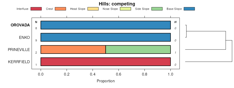
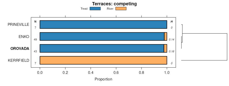
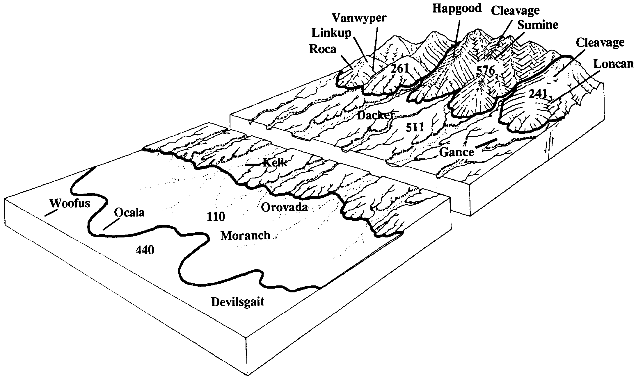
Monarch-Ocala-Orovada association | 110 | 210 | 2518898 | 2qj8c | nv612 | 1968 | 1:24000 |
Chiara-Orovada association | 2577 | 22 | 2519391 | 2qjp1 | nv612 | 1968 | 1:24000 |
Orovada fine sandy loam, 0 to 2 percent slopes | OnA | 2502 | 495621 | jmqs | nv622 | 1972 | 1:24000 |
Orovada gravelly fine sandy loam, 2 to 4 percent slopes | OpB | 1444 | 495622 | jmqt | nv622 | 1972 | 1:24000 |
Allor-Orovada association | 8116 | 761 | 3423156 | 312v6 | nv622 | 1972 | 1:24000 |
Deppy-Puett-Orovada association | 843 | 23924 | 474821 | hy2t | nv760 | 1994 | 1:24000 |
Shawave-Orovada complex 1/ | 411 | 9424 | 474736 | hy02 | nv760 | 1994 | 1:24000 |
Orovada fine sandy loam, 2 to 4 percent slopes 1/ | 276 | 4739 | 474715 | hxzd | nv760 | 1994 | 1:24000 |
Enko-Shabliss-Orovada association | 507 | 13744 | 2633838 | 2rgmc | nv763 | 1986 | 1:24000 |
Orovada-Clurde-Wieland association | 1362 | 6920 | 477064 | j0f5 | nv763 | 1986 | 1:24000 |
Weso-Orovada-Shabliss association | 613 | 5347 | 2633981 | 2rhh4 | nv763 | 1986 | 1:24000 |
Orovada-Tweba-Weso association | 1363 | 3675 | 477065 | j0f6 | nv763 | 1986 | 1:24000 |
Orovada loam, 0 to 2 percent slopes 1/ | 407 | 3388 | 2633978 | 2rhh1 | nv763 | 1986 | 1:24000 |
Puett-Orovada association | 2666 | 2525 | 477209 | j0kv | nv763 | 1986 | 1:24000 |
Weso-Orovada-Tweba associaiton | 1573 | 1710 | 477071 | j0fd | nv763 | 1986 | 1:24000 |
Chiara-Orovada association | 2577 | 1128 | 477196 | j0kf | nv763 | 1986 | 1:24000 |
Shabliss-Orovada-Karpp association | 1207 | 6984 | 2589850 | 2r36c | nv764 | 2021 | 1:24000 |
Orovada-Oupico-Izar association | 931 | 2395 | 475148 | hyfc | nv765 | 1986 | 1:24000 |
Orovada-Xipe-Ocala association | 932 | 1942 | 475149 | hyfd | nv765 | 1986 | 1:24000 |
Orovada, nearly level-Kelk-Orovada association | 930 | 1815 | 475147 | hyfb | nv765 | 1986 | 1:24000 |
Bioya-Orovada association | 232 | 115870 | 478843 | j28k | nv767 | 1986 | 1:24000 |
Orovada-Bioya-Haybourne association | 490 | 28850 | 478937 | j2cl | nv767 | 1986 | 1:24000 |
Orovada-Puett association | 491 | 28488 | 478938 | j2cm | nv767 | 1986 | 1:24000 |
Grina-Kelk-Orovada association | 323 | 16579 | 478885 | j29x | nv767 | 1986 | 1:24000 |
Orovada-Puett-Chiara association | 494 | 13591 | 478940 | j2cp | nv767 | 1986 | 1:24000 |
Moranch-Ocala-Orovada association | 110 | 11848 | 478727 | j24t | nv767 | 1986 | 1:24000 |
Orovada-Humdun-Puett association | 492 | 6613 | 478939 | j2cn | nv767 | 1986 | 1:24000 |
Chiara-Cherry Spring-Orovada association | 370 | 6141 | 478891 | j2b3 | nv767 | 1986 | 1:24000 |
Orovada-Grina-Upsteer association | 496 | 3241 | 478941 | j2cq | nv767 | 1986 | 1:24000 |
Cherry Spring-Orovada-Yuko association | 011 | 2514 | 478721 | j24m | nv767 | 1986 | 1:24000 |
Bucan-Kelk-Orovada association | 590 | 324 | 478967 | j2dk | nv767 | 1986 | 1:24000 |
Orovada-Rasille-Wholan association | 700 | 25666 | 479297 | j2r6 | nv768 | 1985 | 1:63360 |
Glyphs-Muni-Orovada association | 8113 | 21696 | 3423180 | 312v3 | nv768 | 1985 | 1:63360 |
Muni-Orovada-Unius association | 2031 | 17958 | 479091 | 2whmv | nv768 | 1985 | 1:63360 |
Enko-Orovada association, gently sloping | 491 | 14943 | 479280 | j2qn | nv768 | 1985 | 1:63360 |
Pineval-Orovada association | 3964 | 14893 | 479263 | j2q3 | nv768 | 1985 | 1:63360 |
Ricert-Orovada-Tenabo association | 1288 | 13730 | 479055 | j2hd | nv768 | 1985 | 1:63360 |
Allor-Orovada association, moderately sloping | 3072 | 8526 | 479173 | j2m6 | nv768 | 1985 | 1:63360 |
Ricert-Orovada-Broyles association | 1287 | 8412 | 479054 | j2hc | nv768 | 1985 | 1:63360 |
Glyphs-Muni-Orovada association | 2012 | 8241 | 479087 | j2jf | nv768 | 1985 | 1:63360 |
Broyles-Beoska-Orovada association | 237 | 8102 | 479122 | 2whl9 | nv768 | 1985 | 1:63360 |
Zineb-Orovada association | 1682 | 7003 | 479070 | j2hw | nv768 | 1985 | 1:63360 |
McConnel-Orovada-Misad association | 632 | 6261 | 479286 | j2qv | nv768 | 1985 | 1:63360 |
Ricert-Blackhawk-Orovada association | 1289 | 5917 | 479056 | j2hf | nv768 | 1985 | 1:63360 |
Tenabo-Orovada-Buffaran association | 1041 | 5423 | 479032 | j2gn | nv768 | 1985 | 1:63360 |
Allor-Orovada association | 8116 | 5408 | 3423181 | 312v6 | nv768 | 1985 | 1:63360 |
Spasprey-Allor-Orovada association | 3314 | 5077 | 479218 | j2nn | nv768 | 1985 | 1:63360 |
Beoska-Dewar-Orovada association | 177 | 4665 | 479078 | 2v441 | nv768 | 1985 | 1:63360 |
Beoska-Orovada association | 170 | 4381 | 479072 | j2hy | nv768 | 1985 | 1:63360 |
Rotinom-Orovada association | 2022 | 4263 | 479090 | j2jj | nv768 | 1985 | 1:63360 |
Tessfive-Genaw-Orovada association | 2683 | 4139 | 479143 | j2l7 | nv768 | 1985 | 1:63360 |
Tessfive-Perlor-Orovada association | 2684 | 3720 | 479144 | j2l8 | nv768 | 1985 | 1:63360 |
Spasprey-Buffaran-Orovada association | 3312 | 3538 | 479217 | j2nm | nv768 | 1985 | 1:63360 |
Pineval-Orovada-Beoska association | 3961 | 3473 | 479262 | j2q2 | nv768 | 1985 | 1:63360 |
Desatoya-Orovada association | 2781 | 3325 | 479152 | j2lj | nv768 | 1985 | 1:63360 |
Filiran-Buffaran-Orovada association | 675 | 3315 | 479294 | j2r3 | nv768 | 1985 | 1:63360 |
Orovada-McConnel association | 704 | 2965 | 479301 | j2rb | nv768 | 1985 | 1:63360 |
Genaw-Orovada-Puett association | 4072 | 2817 | 479270 | j2qb | nv768 | 1985 | 1:63360 |
Allor-Orovada association, nearly level | 3074 | 2574 | 479175 | j2m8 | nv768 | 1985 | 1:63360 |
Orovada-Valmy association | 705 | 2216 | 479302 | j2rc | nv768 | 1985 | 1:63360 |
Defler-Orovada association | 3011 | 2195 | 479170 | j2m3 | nv768 | 1985 | 1:63360 |
McConnel-Orovada association | 637 | 1999 | 479290 | j2qz | nv768 | 1985 | 1:63360 |
Orovada fine sandy loam, 2 to 4 percent slopes | 701 | 1850 | 479298 | j2r7 | nv768 | 1985 | 1:63360 |
Orovada-Creemon association | 702 | 1356 | 479299 | j2r8 | nv768 | 1985 | 1:63360 |
Enko-Orovada association | 493 | 1116 | 479282 | 2whmt | nv768 | 1985 | 1:63360 |
Unius-Orovada association | 2003 | 893 | 479083 | 2whmr | nv768 | 1985 | 1:63360 |
Orovada fine sandy loam, 0 to 2 percent slopes | 703 | 826 | 479300 | j2r9 | nv768 | 1985 | 1:63360 |
Orovada-Rasille-Wholan association | 8110 | 106 | 3423177 | 312vb | nv768 | 1985 | 1:63360 |
Snapp-Orovada association | 752 | 12749 | 475313 | hylp | nv769 | 1986 | 1:24000 |
Oxcorel-Orovada association | 661 | 3534 | 475295 | 2wd1l | nv769 | 1986 | 1:24000 |
Orovada very fine sandy loam, 2 to 8 percent slopes | 406 | 2236 | 475270 | hyk9 | nv769 | 1986 | 1:24000 |
Misad-Orovada-Snapp association | 675 | 2224 | 475303 | hylc | nv769 | 1986 | 1:24000 |
Orovada loam, 0 to 2 percent slopes | 400 | 1500 | 475269 | hyk8 | nv769 | 1986 | 1:24000 |
Orovada-Goldrun association | 707 | 11000 | 479708 | j35g | nv775 | 1985 | 1:24000 |
Orovada-Wieland-Chiara association | 706 | 7575 | 479707 | j35f | nv775 | 1985 | 1:24000 |
Oxcorel-Orovada association | 2062 | 7540 | 479517 | 2wd1l | nv775 | 1985 | 1:24000 |
Orovada fine sandy loam, 2 to 4 percent slopes | 701 | 7490 | 479702 | j358 | nv775 | 1985 | 1:24000 |
Broyles-Beoska-Orovada association | 237 | 6800 | 479541 | 2whl9 | nv775 | 1985 | 1:24000 |
Pineval-Orovada-Beoska association | 3961 | 5740 | 479661 | j33y | nv775 | 1985 | 1:24000 |
Beoska-Orovada association | 181 | 5380 | 479506 | j2yy | nv775 | 1985 | 1:24000 |
Chiara-Orovada association | 282 | 4925 | 479593 | j31r | nv775 | 1985 | 1:24000 |
Orovada-Kodra-Puett association | 704 | 4525 | 479705 | j35c | nv775 | 1985 | 1:24000 |
Enko-Shabliss-Orovada association | 507 | 4490 | 2633839 | 2rgmd | nv775 | 1985 | 1:24000 |
Creemon-Orovada-Tulase association | 297 | 3015 | 479605 | j324 | nv775 | 1985 | 1:24000 |
Orovada fine sandy loam, 0 to 2 percent slopes | 700 | 2535 | 479701 | j357 | nv775 | 1985 | 1:24000 |
Puett-Genaw-Orovada association | 2561 | 2225 | 479561 | j30q | nv775 | 1985 | 1:24000 |
Beoska-Dewar-Orovada association | 183 | 2195 | 479508 | 2v441 | nv775 | 1985 | 1:24000 |
Creemon-Orovada-Broyles association | 294 | 2140 | 479602 | j321 | nv775 | 1985 | 1:24000 |
Orovada-Reina-Rock outcrop association | 708 | 1800 | 479709 | j35h | nv775 | 1985 | 1:24000 |
Orovada fine sandy loam, cemented substratum, 0 to 2 percent slopes | 702 | 1785 | 479703 | j359 | nv775 | 1985 | 1:24000 |
Orovada-Creemon complex | 705 | 1745 | 479706 | j35d | nv775 | 1985 | 1:24000 |
Genaw-Orovada-Puett association | 4072 | 1565 | 479668 | j345 | nv775 | 1985 | 1:24000 |
Orovada-Sodhouse association | 709 | 750 | 479710 | j35j | nv775 | 1985 | 1:24000 |
Orovada-Goldrun complex | 703 | 580 | 479704 | j35b | nv775 | 1985 | 1:24000 |
Orovada loam, 0 to 2 percent slopes 1/ | 407 | 46 | 2634076 | 2rn3j | nv775 | 1985 | 1:24000 |
Glyphs-Muni-Orovada association | 8113 | 1501 | 3423198 | 312v3 | nv776 | 1983 | 1:63360 |
Orovada silt loam, 0 to 2 percent slopes | OtA | 1071 | 2633869 | 2rgnc | nv776 | 1983 | 1:63360 |
Broyles-Orovada association | 772 | 31748 | 475918 | hz76 | nv777 | 1993 | 1:24000 |
Blackhawk-Golconda-Orovada association | 154 | 23016 | 475564 | hyvs | nv777 | 1993 | 1:24000 |
Bliss-Orovada-Shabliss association | 166 | 16784 | 475599 | hywx | nv777 | 1993 | 1:24000 |
Orovada fine sandy loam, 0 to 2 percent slopes 1/ | 403 | 15124 | 475709 | hz0g | nv777 | 1993 | 1:24000 |
Orovada-Bliss association | 410 | 13459 | 475715 | hz0n | nv777 | 1993 | 1:24000 |
Orovada very fine sandy loam, 2 to 8 percent slopes 1/ | 406 | 13301 | 475711 | hz0j | nv777 | 1993 | 1:24000 |
Bliss-Orovada association | 169 | 13168 | 475602 | hyx0 | nv777 | 1993 | 1:24000 |
Bliss-Dugchip-Orovada association | 165 | 11955 | 475596 | hywt | nv777 | 1993 | 1:24000 |
Orovada loam, 0 to 2 percent slopes 1/ | 407 | 9177 | 475712 | hz0k | nv777 | 1993 | 1:24000 |
Whirlo-Orovada-Snapp association | 823 | 8534 | 475942 | hz7z | nv777 | 1993 | 1:24000 |
Snapp-Orovada association | 752 | 6982 | 475910 | hz6y | nv777 | 1993 | 1:24000 |
Oxcorel-Orovada association | 661 | 6159 | 475867 | 2wd1l | nv777 | 1993 | 1:24000 |
Orovada-Connel complex, 0 to 2 percent slopes 1/ | 4170 | 5293 | 475720 | hz0t | nv777 | 1993 | 1:24000 |
Hunnton-Dugchip-Orovada association | 1171 | 3482 | 475428 | hyqd | nv777 | 1993 | 1:24000 |
Weso-Orovada-Shabliss association | 613 | 2866 | 475832 | hz4f | nv777 | 1993 | 1:24000 |
Enko-Shabliss-Orovada association | 507 | 2772 | 475766 | hz29 | nv777 | 1993 | 1:24000 |
Orovada-Dugchip association | 411 | 2604 | 475716 | hz0p | nv777 | 1993 | 1:24000 |
Dewar-Laped-Orovada association | 721 | 2407 | 475891 | hz6b | nv777 | 1993 | 1:24000 |
Flue-Orovada association | 212 | 2066 | 475633 | hyy0 | nv777 | 1993 | 1:24000 |
Orovada-Goldrun association | 409 | 2011 | 475714 | hz0m | nv777 | 1993 | 1:24000 |
Shabliss-Orovada-Karpp association | 1207 | 339 | 2928251 | 2w2tc | nv780 | 1990 | 1:24000 |
Spasprey-Buffaran-Orovada association | 2291 | 4829 | 480866 | j4ct | nv781 | 1994 | 1:24000 |
Enko-Orovada association | 2220 | 820 | 480857 | 2whmt | nv781 | 1994 | 1:24000 |
Unius-Orovada association | 2240 | 457 | 480859 | 2whmr | nv781 | 1994 | 1:24000 |
Muni-Orovada-Unius association | 2250 | 17 | 480861 | 2whmv | nv781 | 1994 | 1:24000 |
Glyphs-Muni-Orovada association | 8113 | 7454 | 3423003 | 312v3 | nv782 | 2025 | 1:24000 |
Allor-Orovada association | 8116 | 3376 | 3423006 | 312v6 | nv782 | 2025 | 1:24000 |
Orovada-Rasille-Wholan association | 8110 | 56 | 3423000 | 312vb | nv782 | 2025 | 1:24000 |
Deppy-Puett-Orovada association | 843 | 5950 | 3423110 | hy2t | nv792 | 2025 | 1:24000 |
Orovada-Mesman complex, 0 to 5 percent slopes | 188B | 1533 | 489019 | jdvt | or636 | 1991 | 1:24000 |
Nevador-Orovada, dry, complex, 2 to 8 percent slopes | 273 | 51261 | 2219095 | 2dh4q | or644 | 2021 | 1:24000 |
Orovada-Drewsey complex, 0 to 15 percent slopes | 187 | 18267 | 2026423 | 260nh | or644 | 2021 | 1:24000 |
Nevador-Orovada complex, 2 to 8 percent slopes | 254 | 4339 | 2394651 | 2lctt | or644 | 2021 | 1:24000 |
Orovada ashy fine sandy loam, 0 to 1 percent slopes | 244 | 1626 | 2219020 | 2dh29 | or644 | 2021 | 1:24000 |