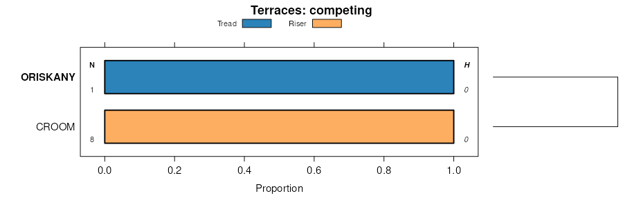
| Oriskany cobbly sandy loam, 8 to 15 percent slopes, extremely stony | OrC | 555 | 2401034 | 2llgq | md001 | 2009 | 1:12000 |
Oriskany cobbly sandy loam, 3 to 8 percent slopes, extremely stony | OrB | 463 | 2401033 | 2llgp | md001 | 2009 | 1:12000 |
Oriskany cobbly sandy loam, 15 to 25 percent slopes, extremely stony | OrD | 177 | 2401035 | 2llgr | md001 | 2009 | 1:12000 |
Oriskany-Urban land complex, 0 to 8 percent slopes | OuB | 58 | 2401302 | 2llrc | md001 | 2009 | 1:12000 |
Oriskany-Urban land complex, 8 to 15 percent slopes | OuC | 40 | 2401008 | 2llfw | md001 | 2009 | 1:12000 |
Oriskany cobbly sandy loam, 15 to 35 percent slopes, extremely stony | 43D | 9601 | 834380 | x07h | va005 | 2003 | 1:24000 |
Oriskany-Murrill complex, 15 to 35 percent slopes, very stony | 45D | 7615 | 834384 | x07m | va005 | 2003 | 1:24000 |
Oriskany cobbly sandy loam, 8 to 15 percent slopes, extremely stony | 43C | 5108 | 834379 | x07g | va005 | 2003 | 1:24000 |
Oriskany-Murrill complex, 35 to 55 percent slopes, extremely stony | 45E | 3046 | 834385 | x07n | va005 | 2003 | 1:24000 |
Oriskany cobbly sandy loam, 35 to 55 percent slopes, extremely stony | 43E | 2868 | 834381 | x07j | va005 | 2003 | 1:24000 |
Oriskany extremely bouldery sandy loam, 25 to 55 percent slopes, very rubbly | 44E | 1882 | 834382 | x07k | va005 | 2003 | 1:24000 |
Oriskany-Murrill complex, 8 to 15 percent slopes, very stony | 45C | 1575 | 834383 | x07l | va005 | 2003 | 1:24000 |
Oriskany cobbly sandy loam, 3 to 8 percent slopes, very stony | 42B | 332 | 834378 | x07f | va005 | 2003 | 1:24000 |
Oriskany cobbly sandy loam, 15 to 35 percent slopes, extremely stony | 44D | 11699 | 1451455 | 1kqc4 | va017 | 2005 | 1:24000 |
Oriskany cobbly sandy loam, 35 to 55 percent slopes, extremely stony | 44E | 9505 | 1451456 | 1kqc5 | va017 | 2005 | 1:24000 |
Oriskany-Murrill complex, 15 to 35 percent slopes, very stony | 46D | 8978 | 1451458 | 1kqc7 | va017 | 2005 | 1:24000 |
Oriskany-Murrill complex, 35 to 55 percent slopes, extremely stony | 47E | 6966 | 1451459 | 1kqc8 | va017 | 2005 | 1:24000 |
Oriskany cobbly sandy loam, 8 to 15 percent slopes, extremely stony | 44C | 6167 | 1451454 | 1kqc3 | va017 | 2005 | 1:24000 |
Oriskany extremely bouldery sandy loam, 25 to 55 percent slopes, very rubbly | 45E | 4759 | 1451460 | 1kqc9 | va017 | 2005 | 1:24000 |
Oriskany-Murrill complex, 8 to 15 percent slopes, very stony | 46C | 1688 | 1451457 | 1kqc6 | va017 | 2005 | 1:24000 |
Oriskany cobbly sandy loam, 3 to 8 percent slopes, very stony | 43B | 1346 | 1451453 | 1kqc2 | va017 | 2005 | 1:24000 |
Oriskany gravelly fine sandy loam, 15 to 35 percent slopes, extremely stony | 26D | 12781 | 1402665 | 1j2l8 | va021 | 2005 | 1:24000 |
Oriskany gravelly fine sandy loam, 8 to 15 percent slopes, extremely stony | 26C | 2747 | 1402664 | 1j2l7 | va021 | 2005 | 1:24000 |
Oriskany gravelly fine sandy loam, 15 to 55 percent slopes, very rubbly | 27E | 2183 | 1402672 | 1j2lh | va021 | 2005 | 1:24000 |
Oriskany very cobbly fine sandy loam, 35 to 55 percent slopes, extremely stony | 19E | 370 | 1670941 | 1t2rb | va027 | 2006 | 1:24000 |
Oriskany very cobbly fine sandy loam, 15 to 35 percent slopes, extremely stony | 19D | 111 | 1670858 | 1t2nn | va027 | 2006 | 1:24000 |
Oriskany gravelly fine sandy loam, 15 to 35 percent slopes, extremely stony | 27E | 6796 | 2481084 | 2p8rz | va045 | 2010 | 1:24000 |
Oriskany gravelly fine sandy loam, 8 to 15 percent slopes, extremely stony | 27C | 2702 | 2481083 | 2p8ry | va045 | 2010 | 1:24000 |
Oriskany gravelly fine sandy loam, 15 to 55 percent slopes, very rubbly | 28F | 213 | 2481093 | 2p8s8 | va045 | 2010 | 1:24000 |
Oriskany-Murrill complex, 15 to 35 percent slopes, very stony | 42E | 17614 | 2512089 | 2q9j6 | va091 | 2010 | 1:24000 |
Oriskany-Murrill complex, 8 to 15 percent slopes, very stony | 42C | 8632 | 2512091 | 2q9j8 | va091 | 2010 | 1:24000 |
Oriskany-Murrill complex, 35 to 55 percent slopes, extremely stony | 43F | 6169 | 2512090 | 2q9j7 | va091 | 2010 | 1:24000 |
Oriskany cobbly sandy loam, 35 to 55 percent slopes, extremely stony | 40F | 5950 | 2512086 | 2q9j3 | va091 | 2010 | 1:24000 |
Oriskany cobbly sandy loam, 15 to 35 percent slopes, extremely stony | 40E | 2795 | 2512085 | 2q9j2 | va091 | 2010 | 1:24000 |
Oriskany extremely bouldery sandy loam, 25 to 55 percent slopes, very rubbly | 41F | 2177 | 2512088 | 2q9j5 | va091 | 2010 | 1:24000 |
Oriskany cobbly sandy loam, 8 to 15 percent slopes, extremely stony | 40C | 1300 | 2512087 | 2q9j4 | va091 | 2010 | 1:24000 |
Oriskany cobbly loam, 35 to 55 percent slopes, extremely stony | 22E | 7221 | 521715 | khwj | va105 | 1997 | 1:24000 |
Oriskany cobbly loam, 7 to 15 percent slopes, extremely stony | 22C | 160 | 521714 | khwh | va105 | 1997 | 1:24000 |
Oriskany-Murrill complex, 15 to 35 percent slopes, extremely stony | 49E | 8491 | 2514833 | 2qdcb | va163 | 2010 | 1:24000 |
Oriskany-Laidig complex, 15 to 35 percent slopes, extremely stony | 47E | 7084 | 2514830 | 2qdc7 | va163 | 2010 | 1:24000 |
Oriskany-Murrill complex, 35 to 55 percent slopes, extremely stony | 49F | 5308 | 2514834 | 2qdcc | va163 | 2010 | 1:24000 |
Oriskany cobbly sandy loam, 35 to 55 percent slopes, extremely stony | 48F | 5283 | 2514831 | 2qdc8 | va163 | 2010 | 1:24000 |
Oriskany-Murrill complex, 3 to 15 percent slopes, extremely stony | 49C | 4403 | 2514832 | 2qdc9 | va163 | 2010 | 1:24000 |
Oriskany-Laidig complex, 3 to 15 percent slopes, extremely stony | 47C | 3062 | 2514829 | 2qdc6 | va163 | 2010 | 1:24000 |
Oriskany very cobbly fine sandy loam, 35 to 55 percent slopes, extremely stony | 42E | 2872 | 1671210 | 1t310 | va167 | 2006 | 1:24000 |
Oriskany very cobbly fine sandy loam, 15 to 35 percent slopes, extremely stony | 42D | 1547 | 1671879 | 1t3ql | va167 | 2006 | 1:24000 |
Oriskany very cobbly fine sandy loam, 8 to 15 percent slopes, extremely stony | 42C | 329 | 1671878 | 1t3qk | va167 | 2006 | 1:24000 |
Oriskany very cobbly fine sandy loam, 35 to 55 percent slopes, extremely stony | 34E | 6235 | 778090 | v3np | va169 | 2003 | 1:24000 |
Oriskany very stony fine sandy loam, 25 to 55 percent slopes, rubbly | 35E | 1450 | 778092 | v3nr | va169 | 2003 | 1:24000 |
Oriskany very cobbly fine sandy loam, 15 to 35 percent slopes, extremely stony | 34D | 1430 | 778089 | v3nn | va169 | 2003 | 1:24000 |
Oriskany very cobbly fine sandy loam, 8 to 15 percent slopes, extremely stony | 34C | 635 | 778088 | v3nm | va169 | 2003 | 1:24000 |
Oriskany very cobbly fine sandy loam, 3 to 8 percent slopes, very stony | 34B | 609 | 778087 | v3nl | va169 | 2003 | 1:24000 |
Oriskany gravelly fine sandy loam, 15 to 35 percent slopes, very stony | 38D | 29212 | 522152 | kjbm | va185 | 1996 | 1:24000 |
Oriskany gravelly fine sandy loam, 35 to 55 percent slopes, extremely stony | 38E | 20434 | 522153 | kjbn | va185 | 1996 | 1:24000 |
Oriskany gravelly fine sandy loam, 7 to 15 percent slopes, very stony | 38C | 3301 | 522151 | kjbl | va185 | 1996 | 1:24000 |
Oriskany gravelly fine sandy loam, 7 to 15 percent slopes | 37C | 2863 | 522149 | kjbj | va185 | 1996 | 1:24000 |
Oriskany gravelly fine sandy loam, 15 to 25 percent slopes | 37D | 1664 | 522150 | kjbk | va185 | 1996 | 1:24000 |
Oriskany very cobbly fine sandy loam, 15 to 35 percent slopes, extremely stony | 61E | 2273 | 2508598 | 2q7rc | va195 | 2010 | 1:24000 |
Oriskany very cobbly fine sandy loam, 35 to 55 percent slopes, extremely stony | 61F | 659 | 2508599 | 2q7rd | va195 | 2010 | 1:24000 |
Oriskany very cobbly fine sandy loam, 8 to 15 percent slopes, extremely stony | 61C | 417 | 2508597 | 2q7rb | va195 | 2010 | 1:24000 |
Oriskany very stony fine sandy loam, 25 to 55 percent slopes, rubbly | 62F | 365 | 2508600 | 2q7rf | va195 | 2010 | 1:24000 |
Oriskany very cobbly sandy loam, 15 to 35 percent slopes, very stony | 138D | 14519 | 2525455 | 2rtk5 | va606 | | 1:24000 |
Oriskany very cobbly sandy loam, 35 to 60 percent slopes, very stony | 138E | 11854 | 2525456 | 2rtk6 | va606 | | 1:24000 |
Oriskany very cobbly sandy loam, 35 to 60 percent slopes, rubbly | 138ES | 5159 | 2525459 | 2rtk9 | va606 | | 1:24000 |
Oriskany very cobbly sandy loam, 15 to 35 percent slopes, rubbly | 138DS | 4461 | 2525458 | 2rtk8 | va606 | | 1:24000 |
Lily-Oriskany complex, 35 to 60 percent slopes, rubbly | 175E | 3898 | 2556880 | 2r7dp | va606 | | 1:24000 |
Oriskany very cobbly sandy loam, 3 to 15 percent slopes, very stony | 138C | 2780 | 2525454 | 2rtk4 | va606 | | 1:24000 |
Lily-Oriskany complex, 15 to 35 percent slopes, rubbly | 175D | 2259 | 2556879 | 2r7dn | va606 | | 1:24000 |
Oriskany very cobbly sandy loam, 3 to 15 percent slopes, rubbly | 138CS | 2007 | 2525457 | 2rtk7 | va606 | | 1:24000 |
Oriskany gravelly fine sandy loam, 8 to 15 percent slopes, very stony | OaC | 6 | 2516618 | 2619r | wv713 | | 1:24000 |


