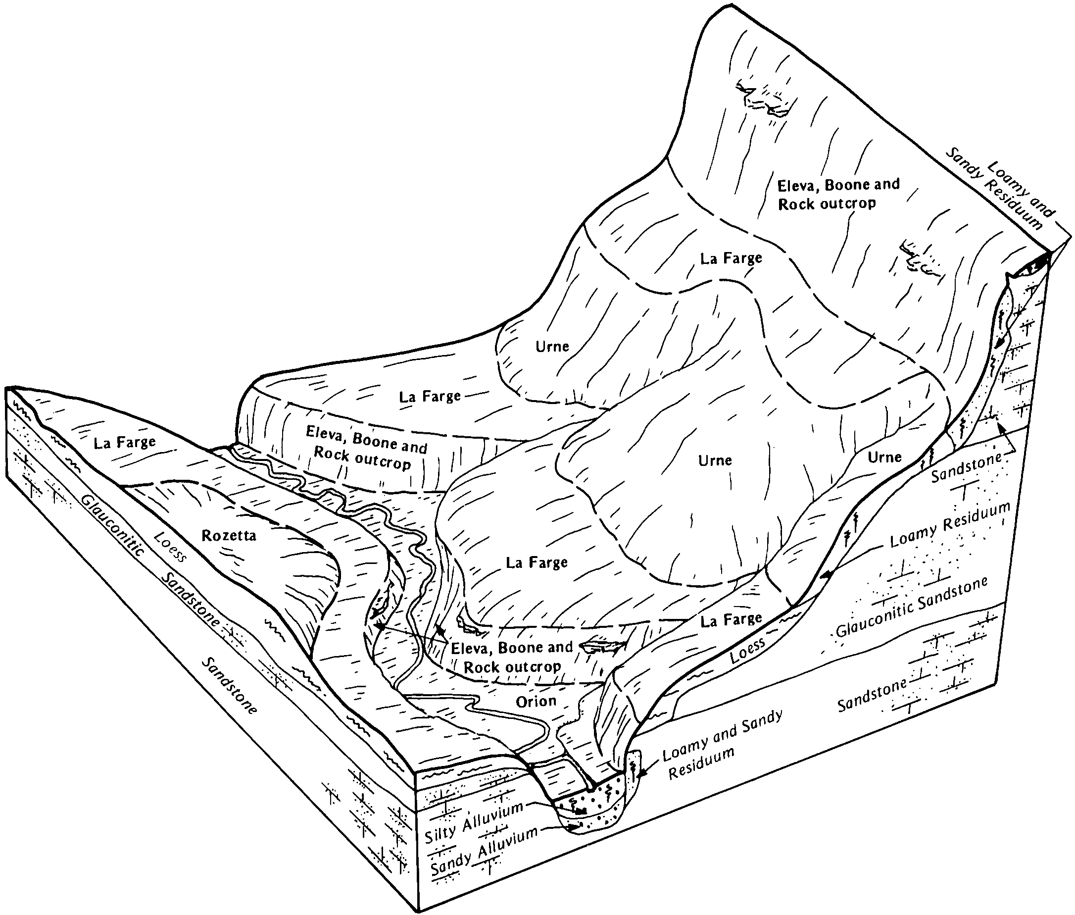
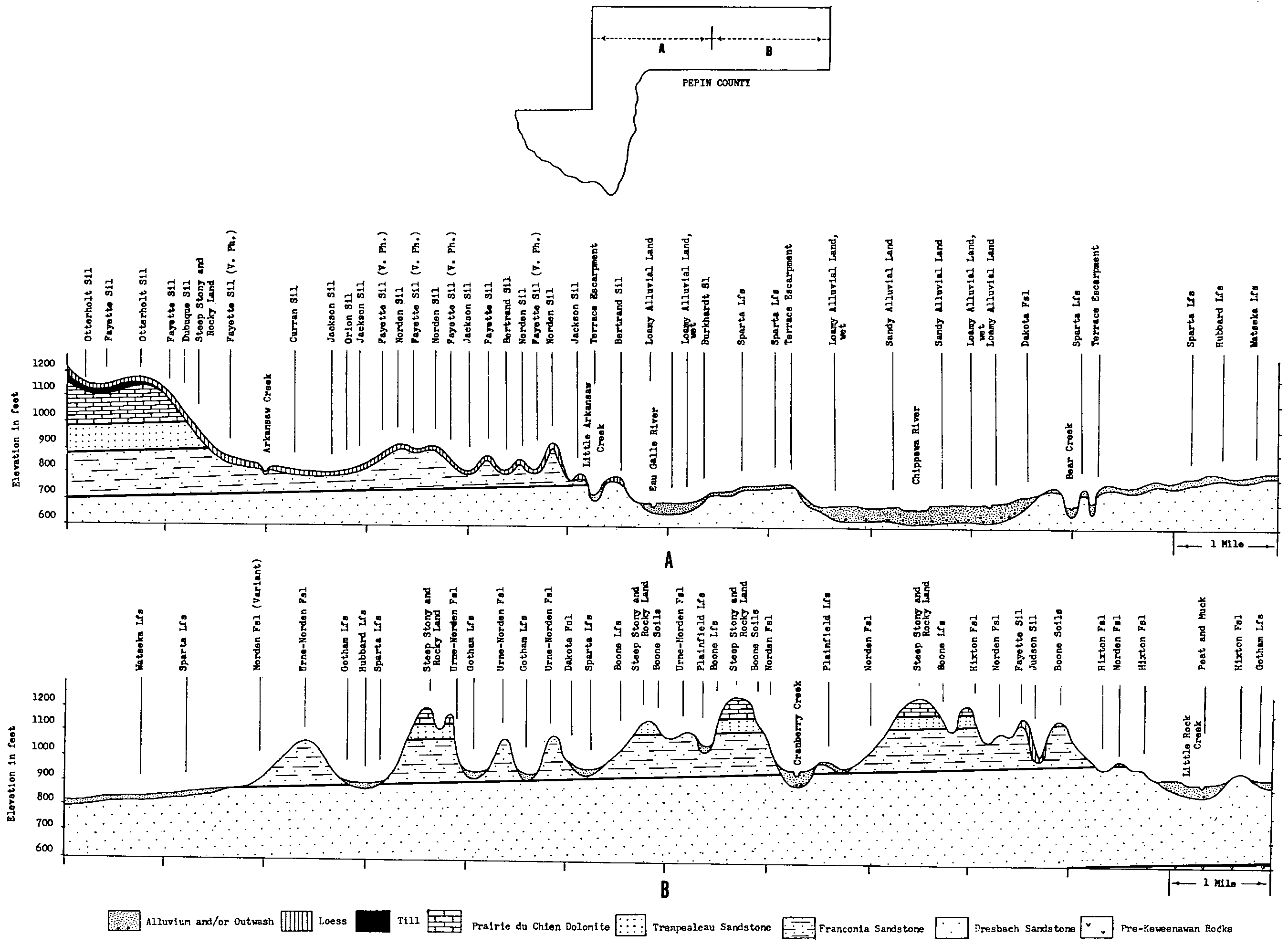
| Orion silt loam, 0 to 3 percent slopes, occasionally flooded | 930 | 1377 | 402615 | 2wtqv | ia005 | 1992 | 1:15840 |
Orion silt loam, 0 to 2 percent slopes, occasionally flooded | 930 | 568 | 1689584 | 1tq4q | ia017 | 2008 | 1:12000 |
Orion silt loam, 2 to 5 percent slopes, occassionally flooded | 930B | 2690 | 404323 | 2wtqx | ia043 | 1979 | 1:15840 |
Orion silt loam, 0 to 3 percent slopes, occasionally flooded | 930 | 671 | 404322 | 2wtqv | ia043 | 1979 | 1:15840 |
Orion silt loam, 2 to 5 percent slopes, occassionally flooded | 930B | 4078 | 405487 | 2wtqx | ia061 | 1983 | 1:15840 |
Orion silt loam, 0 to 3 percent slopes, occasionally flooded | 930 | 2876 | 407571 | 2wtqv | ia097 | 1988 | 1:15840 |
Orion silt loam, 2 to 5 percent slopes, occassionally flooded | 930B | 2348 | 407572 | 2wtqx | ia097 | 1988 | 1:15840 |
Orion silt loam, 0 to 3 percent slopes, occasionally flooded | 930 | 660 | 408222 | 2wtqv | ia105 | 1988 | 1:15840 |
Birds-Orion Complex, channeled, O to 2 percent slopes, frequently flooded | 1317 | 3791 | 2506536 | 2q5t3 | ia111 | 1976 | 1:15840 |
Orion silt loam, 0 to 3 percent slopes | 930 | 1314 | 410050 | frpf | ia139 | 1986 | 1:15840 |
Orion silt loam, 0 to 2 percent slopes, frequently flooded | 3415A | 1249 | 1407196 | 1j79f | il007 | 2006 | 1:12000 |
Orion silt loam, 0 to 2 percent slopes, occasionally flooded | 8415A | 1011 | 172978 | 2ybgy | il009 | 1984 | 1:12000 |
Orion silt loam, 0 to 2 percent slopes, frequently flooded | 3415A | 890 | 2542032 | 2ybgv | il013 | 1986 | 1:15840 |
Orion silt loam, 0 to 2 percent slopes, occasionally flooded | 8415A | 770 | 2542034 | 2ybgy | il013 | 1986 | 1:15840 |
Orion silt loam, 0 to 2 percent slopes, rarely flooded | 7415A | 388 | 2542033 | 2ybgz | il013 | 1986 | 1:15840 |
Orion silt loam, 0 to 2 percent slopes, frequently flooded | 3415A | 2238 | 850322 | 2ybgv | il015 | 2005 | 1:12000 |
Orion silt loam, 0 to 3 percent slopes, occasionally flooded | 8415A | 469 | 3000304 | 2wtqv | il015 | 2005 | 1:12000 |
Orion silt loam, 0 to 2 percent slopes, rarely flooded | 7415A | 392 | 1542856 | 2ybgz | il015 | 2005 | 1:12000 |
Orion silt loam, warm mesic, 0 to 2 percent slopes, frequently flooded | 3415wA | 1262 | 174829 | 2zxcd | il035 | 1992 | 1:15840 |
Orion silt loam, 0 to 2 percent slopes, frequently flooded | 3415A | 4914 | 615694 | 2ybgv | il057 | 1997 | 1:12000 |
Orion silt loam, 0 to 2 percent slopes, occasionally flooded | 8415A | 1637 | 615705 | 2ybgy | il057 | 1997 | 1:12000 |
Orion silt loam, 0 to 2 percent slopes, occasionally flooded | 8415A | 994 | 175230 | 2ybgy | il067 | 1993 | 1:15840 |
Orion silt loam, 0 to 2 percent slopes, frequently flooded | 3415A | 718 | 175183 | 2ybgv | il067 | 1993 | 1:15840 |
Orion silt loam, 0 to 2 percent slopes, frequently flooded | 3415A | 594 | 632715 | 2ybgv | il071 | 2005 | 1:12000 |
Orion silt loam, 0 to 2 percent slopes, frequently flooded | 3415A | 6489 | 244853 | 2ybgv | il073 | 2001 | 1:12000 |
Orion silt loam, 0 to 2 percent slopes, occasionally flooded | 8415A | 210 | 244867 | 2ybgy | il073 | 2001 | 1:12000 |
Orion silt loam, warm mesic, 0 to 2 percent slopes, frequently flooded | 3415wA | 5 | 1540614 | 2zxcd | il081 | 2005 | 1:12000 |
Orion silt loam, 0 to 3 percent slopes, occasionally flooded | 8415A | 5359 | 1949669 | 2wtqv | il085 | 1990 | 1:12000 |
Orion silt loam, 0 to 2 percent slopes, frequently flooded | 3415A | 2333 | 680986 | 2ybgv | il095 | 2002 | 1:12000 |
Orion silt loam, warm mesic, 0 to 2 percent slopes, frequently flooded | 3415wA | 7523 | 198931 | 2zxcd | il119 | 2001 | 1:12000 |
Orion silt loam, warm mesic, 0 to 2 percent slopes, occasionally flooded | 8415wA | 168 | 198891 | 2zxc9 | il119 | 2001 | 1:12000 |
Orion silt loam, warm mesic, 0 to 2 percent slopes, frequently flooded | 3415wA | 1253 | 2027396 | 2zxcd | il121 | 2008 | 1:12000 |
Orion silt loam, 0 to 2 percent slopes, frequently flooded | 3415A | 13892 | 245023 | 2ybgv | il131 | 2000 | 1:12000 |
Orion silt loam, 0 to 2 percent slopes, rarely flooded | 7415A | 750 | 245031 | 2ybgz | il131 | 2000 | 1:12000 |
Orion silt loam, 0 to 2 percent slopes, frequently flooded | 3415A | 1687 | 1672156 | 2ybgv | il137 | 1984 | 1:15840 |
Orion silt loam, 0 to 2 percent slopes, frequently flooded | 3415A | 2331 | 1398758 | 2ybgv | il141 | 2005 | 1:12000 |
Orion silt loam, 0 to 2 percent slopes, frequently flooded | 3415A | 453 | 208990 | 2ybgv | il143 | 1986 | 1:15840 |
Orion silt loam, 0 to 2 percent slopes, occasionally flooded | 8415A | 5196 | 201974 | 2ybgy | il149 | 2001 | 1:12000 |
Orion silt loam, 0 to 2 percent slopes, frequently flooded | 3415A | 4867 | 201335 | 2ybgv | il149 | 2001 | 1:12000 |
Orion silt loam, 0 to 2 percent slopes, frequently flooded, long duration | 3415L | 275 | 201336 | 2ybgw | il149 | 2001 | 1:12000 |
Orion silt loam, 0 to 2 percent slopes, frequently flooded | 3415A | 9193 | 198696 | 2ybgv | il161 | 2002 | 1:12000 |
Orion silt loam, 0 to 2 percent slopes, rarely flooded | 7415A | 1507 | 198706 | 2ybgz | il161 | 2002 | 1:12000 |
Orion silt loam, warm mesic, 0 to 2 percent slopes, frequently flooded | 3415wA | 691 | 182993 | 2zxcd | il163 | 1997 | 1:12000 |
Orion silt loam, 0 to 2 percent slopes, occasionally flooded | 8415A | 1286 | 202246 | 2ybgy | il169 | 2000 | 1:12000 |
Orion silt loam, 0 to 2 percent slopes, frequently flooded | 3415A | 2123 | 2542090 | 2ybgv | il171 | 1984 | 1:12000 |
Orion silt loam, 0 to 3 percent slopes, occasionally flooded | 8415A | 1345 | 1592036 | 2wtqv | il177 | 2006 | 1:12000 |
Orion silt loam, 0 to 2 percent slopes, frequently flooded | 3415A | 6684 | 244933 | 2ybgv | il187 | 2002 | 1:12000 |
Orion silt loam, warm mesic, 0 to 2 percent slopes, frequently flooded | 3415wA | 3457 | 1528991 | 2zxcd | il189 | 2006 | 1:12000 |
Orion silt loam, 0 to 2 percent slopes, frequently flooded | 3415A | 7698 | 793118 | 2ybgv | il195 | 2003 | 1:12000 |
Orion silt loam, 0 to 2 percent slopes, occasionally flooded | 8415A | 845 | 793147 | 2ybgy | il195 | 2003 | 1:12000 |
Orion silt loam, 0 to 2 percent slopes, frequently flooded | 3415A | 1423 | 174217 | 5v8x | il201 | 1997 | 1:12000 |
Orion silt loam, 0 to 2 percent slopes, occasionally flooded | 66048 | 830 | 888764 | yttt | mo045 | 1992 | 1:24000 |
Orion silt loam, 0 to 3 percent slopes, occasionally flooded | 628A | 2167 | 2561778 | 2wtqv | wi011 | 1960 | 1:12000 |
Orion silt loam, 0 to 3 percent slopes, occasionally flooded | 628A | 1940 | 421564 | 2wtqv | wi017 | 1985 | 1:15840 |
Orion silt loam, 0 to 3 percent slopes, occasionally flooded | 628A | 4769 | 2499027 | 2wtqv | wi023 | 1960 | 1:12000 |
Orion silt loam, wet | 629A | 5412 | 753550 | t942 | wi025 | 1972 | 1:15840 |
Orion silt loam, 0 to 3 percent slopes, occasionally flooded | 628A | 2978 | 753549 | 2wtqv | wi025 | 1972 | 1:15840 |
Orion silt loam, 0 to 3 percent slopes, occasionally flooded | 628A | 6552 | 2499028 | 2wtqv | wi033 | 2003 | 1:12000 |
Orion silt loam, 0 to 3 percent slopes, occasionally flooded | 628A | 2621 | 421817 | 2wtqv | wi035 | 1974 | 1:12000 |
Orion silt loam, 0 to 3 percent slopes, occasionally flooded | 628A | 3422 | 424313 | 2wtqv | wi043 | 1959 | 1:20000 |
Orion silt loam, 0 to 3 percent slopes, occasionally flooded | 628A | 7709 | 425337 | 2wtqv | wi045 | 1969 | 1:12000 |
Orion silt loam, 0 to 3 percent slopes, occasionally flooded | 628A | 9370 | 2806642 | 2wtqv | wi049 | 1960 | 1:20000 |
Orion silt loam, 0 to 3 percent slopes, occasionally flooded | 628A | 3853 | 2499029 | 2wtqv | wi053 | 1994 | 1:12000 |
Orion silt loam, 0 to 3 percent slopes, occasionally flooded | 628A | 5030 | 2561478 | 2wtqv | wi057 | 1987 | 1:12000 |
Orion silt loam, 0 to 3 percent slopes, occasionally flooded | 628A | 3407 | 2499030 | 2wtqv | wi063 | 2001 | 1:12000 |
Orion silt loam, 0 to 3 percent slopes, occasionally flooded | 628A | 8406 | 424874 | 2wtqv | wi065 | 1964 | 1:15840 |
Orion silt loam, 0 to 3 percent slopes, occasionally flooded | 628A | 18336 | 2685049 | 2wtqv | wi081 | 1981 | 1:12000 |
Orion silt loam, 0 to 3 percent slopes, occasionally flooded | 628A | 2155 | 2499031 | 2wtqv | wi091 | 1998 | 1:12000 |
Scotah-Orion-Riverwash complex, 0 to 2 percent slopes, frequently flooded | 1608A | 2346 | 1698607 | 1v0js | wi093 | 2006 | 1:12000 |
Orion-Coland complex, 0 to 2 percent slopes, occasionally flooded | 1628A | 731 | 1701010 | 1v319 | wi093 | 2006 | 1:12000 |
Orion silt loam, 0 to 3 percent slopes, occasionally flooded | 628A | 515 | 1693138 | 2wtqv | wi093 | 2006 | 1:12000 |
Orion silt loam, till plain, 0 to 3 percent slopes, occasionally flooded | 668A | 479 | 1701231 | 2wtqw | wi093 | 2006 | 1:12000 |
Orion silt loam, 0 to 3 percent slopes, occasionally flooded | 628A | 14863 | 2499032 | 2wtqv | wi103 | 2002 | 1:12000 |
Orion silt loam, till plain, 0 to 3 percent slopes, occasionally flooded | 668A | 1480 | 3000299 | 2wtqw | wi109 | 1975 | 1:15840 |
Orion silt loam, 0 to 3 percent slopes, occasionally flooded | 628A | 712 | 422168 | 2wtqv | wi109 | 1975 | 1:15840 |
Orion silt loam, 0 to 3 percent slopes, occasionally flooded | 628A | 4897 | 423186 | 2wtqv | wi111 | 1977 | 1:15840 |
Orion silt loam, 0 to 3 percent slopes, occasionally flooded | 628A | 12283 | 2639499 | 2wtqv | wi121 | 1969 | 1:12000 |
Orion silt loam, 0 to 3 percent slopes, occasionally flooded | 628A | 7468 | 2499033 | 2wtqv | wi123 | 1965 | 1:12000 |


