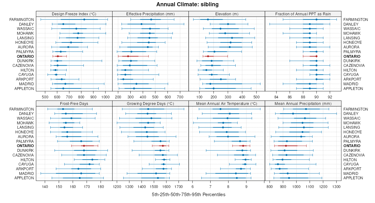
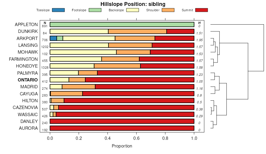
| Ontario loam, 3 to 8 percent slopes | OnB | 15270 | 289461 | 2w3ps | ny011 | 1968 | 1:15840 |
Ontario, Honeoye, and Lansing soils, 20 to 35 percent slopes | OtE | 8137 | 289470 | 2w3mx | ny011 | 1968 | 1:15840 |
Ontario loam, 8 to 15 percent slopes | OnC | 2849 | 289462 | 2w3px | ny011 | 1968 | 1:15840 |
Ontario fine sandy loam, 3 to 8 percent slopes | OfB | 2554 | 289458 | 2xgg3 | ny011 | 1968 | 1:15840 |
Ontario silt loam, moderately shallow variant, 3 to 8 percent slopes | OrB | 2150 | 289468 | 9q6p | ny011 | 1968 | 1:15840 |
Ontario, Honeoye, and Lansing soils, 35 to 50 percent slopes | OtF | 1983 | 289471 | 2w3mq | ny011 | 1968 | 1:15840 |
Ontario fine sandy loam, 8 to 15 percent slopes | OfC | 1254 | 289459 | 2xgg4 | ny011 | 1968 | 1:15840 |
Ontario loam, 14 to 20 percent slopes | OnD | 680 | 289465 | 2w3q2 | ny011 | 1968 | 1:15840 |
Ontario silt loam, moderately shallow variant, 0 to 3 percent slopes | OrA | 600 | 289467 | 9q6n | ny011 | 1968 | 1:15840 |
Ontario silt loam, moderately shallow variant, 8 to 14 percent slopes | OrC | 373 | 289469 | 9q6q | ny011 | 1968 | 1:15840 |
Ontario loam, 3 to 8 percent slopes | OnB | 22461 | 301763 | 2w3ps | ny037 | 2004 | 1:24000 |
Ontario loam, 0 to 3 percent slopes | OnA | 4869 | 301762 | 2wrdp | ny037 | 2004 | 1:24000 |
Ontario loam, 8 to 15 percent slopes | OnC | 4315 | 301764 | 2w3px | ny037 | 2004 | 1:24000 |
Ontario loam, 3 to 8 percent slopes, stony | OsB | 1495 | 301767 | 2w3pv | ny037 | 2004 | 1:24000 |
Ontario loam, 15 to 25 percent slopes | OnD | 636 | 301765 | 2w3q3 | ny037 | 2004 | 1:24000 |
Ontario and Lansing soils, 25 to 40 percent slopes | OrE | 464 | 301766 | 2w3mn | ny037 | 2004 | 1:24000 |
Ontario loam, 8 to 15 percent slopes, stony | OsC | 123 | 301768 | 2w3pz | ny037 | 2004 | 1:24000 |
Ontario silt loam, 15 to 25 percent slopes | OnD | 1799 | 2518380 | 2xggc | ny043 | 2018 | 1:24000 |
Ontario silt loam, 8 to 15 percent slopes | OnC | 787 | 2518379 | 2xggb | ny043 | 2018 | 1:24000 |
Ontario silt loam, 3 to 8 percent slopes | OnB | 617 | 2518378 | 2xgg9 | ny043 | 2018 | 1:24000 |
Ontario-Hilton complex, 3 to 8 percent slopes | 167B | 16711 | 3105787 | 2ywl6 | ny051 | 2019 | 1:24000 |
Ontario loam, 8 to 15 percent slopes | 52C | 3850 | 3100284 | 2w3px | ny051 | 2019 | 1:24000 |
Ontario loam, 15 to 25 percent slopes | 52D | 1430 | 3105686 | 2w3q3 | ny051 | 2019 | 1:24000 |
Ontario loam, 3 to 8 percent slopes | 52B | 1422 | 3105684 | 2w3ps | ny051 | 2019 | 1:24000 |
Ontario-Hilton complex, 0 to 3 percent slopes | 167A | 923 | 3105786 | 2ywl5 | ny051 | 2019 | 1:24000 |
Ontario fine sandy loam, 8 to 15 percent slopes | 252C | 740 | 3100289 | 2xgg4 | ny051 | 2019 | 1:24000 |
Ontario loam, 25 to 35 percent slopes | 52E | 623 | 3105687 | 2y9w6 | ny051 | 2019 | 1:24000 |
Ontario fine sandy loam, 3 to 8 percent slopes | 252B | 239 | 3105775 | 2xgg3 | ny051 | 2019 | 1:24000 |
Ontario fine sandy loam, 15 to 25 percent slopes | 252D | 201 | 3105777 | 2xgg5 | ny051 | 2019 | 1:24000 |
Ontario loam, 3 to 8 percent slopes | OnB | 1654 | 292608 | 2w3ps | ny053 | 1975 | 1:15840 |
Ontario loam, 8 to 15 percent slopes | OnC | 489 | 292609 | 2w3px | ny053 | 1975 | 1:15840 |
Ontario loam, 3 to 8 percent slopes | OnB | 21874 | 292742 | 2w3ps | ny055 | 1967 | 1:15840 |
Ontario loam, 8 to 15 percent slopes | OnC | 7674 | 292743 | 2w3px | ny055 | 1967 | 1:15840 |
Ontario fine sandy loam, 3 to 8 percent slopes | OfB | 5017 | 292740 | 2xgg3 | ny055 | 1967 | 1:15840 |
Ontario loam, 15 to 25 percent slopes | OnD3 | 1997 | 292745 | 2w3q3 | ny055 | 1967 | 1:15840 |
Ontario loam, 25 to 60 percent slopes | OnF | 1735 | 292746 | 2w3q7 | ny055 | 1967 | 1:15840 |
Ontario fine sandy loam, 8 to 15 percent slopes | OfC | 1486 | 292741 | 2xgg4 | ny055 | 1967 | 1:15840 |
Ontario-Palmyra-Arkport complex, 25 to 60 percent slopes | OpF | 1102 | 292749 | 2w3q8 | ny055 | 1967 | 1:15840 |
Ontario-Palmyra-Arkport complex, 8 to 15 percent slopes | OpC | 863 | 292747 | 2w3py | ny055 | 1967 | 1:15840 |
Ontario-Palmyra-Arkport complex, 15 to 25 percent slopes | OpD | 836 | 292748 | 2w3q4 | ny055 | 1967 | 1:15840 |
Ontario loam, 3 to 8 percent slopes | OgB | 10884 | 293631 | 2w3ps | ny067 | 1973 | 1:20000 |
Honeoye, Lansing, and Ontario soils, 25 to 35 percent slopes | HTE | 9079 | 293566 | 2w3mt | ny067 | 1973 | 1:20000 |
Ontario gravelly loam, 8 to 15 percent slopes | OnC | 5810 | 293632 | 2w3qc | ny067 | 1973 | 1:20000 |
Honeoye, Lansing, and Ontario soils, 35 to 50 percent slopes | HTF | 5395 | 293567 | 2w3mr | ny067 | 1973 | 1:20000 |
Ontario and Madrid soils, 15 to 25 percent slopes | OpD | 4049 | 293635 | 2w3qg | ny067 | 1973 | 1:20000 |
Ontario loam, 3 to 8 percent slopes | 116B | 5716 | 1727615 | 2w3ps | ny069 | 2012 | 1:12000 |
Ontario fine sandy loam, 3 to 8 percent slopes | 112B | 5529 | 1727607 | 2xgg3 | ny069 | 2012 | 1:12000 |
Ontario loam, 8 to 15 percent slopes | 116C | 2179 | 1727614 | 2w3px | ny069 | 2012 | 1:12000 |
Ontario fine sandy loam, 25 to 35 percent slopes | 112E | 2081 | 1727609 | 2xgg8 | ny069 | 2012 | 1:12000 |
Ontario fine sandy loam, 8 to 15 percent slopes | 112C | 1906 | 1727608 | 2xgg4 | ny069 | 2012 | 1:12000 |
Ontario, Honeoye, and Lansing soils, 35 to 55 percent slopes | 118F | 1866 | 1727616 | 2w3mp | ny069 | 2012 | 1:12000 |
Ontario fine sandy loam, 15 to 25 percent slopes | 112D | 1310 | 1727610 | 2xgg5 | ny069 | 2012 | 1:12000 |
Ontario loam, 15 to 25 percent slopes | 116D | 1273 | 1727613 | 2w3q3 | ny069 | 2012 | 1:12000 |
Ontario gravelly loam, 3 to 8 percent slopes | 114B | 1101 | 1727612 | 2w3q9 | ny069 | 2012 | 1:12000 |
Ontario gravelly loam, 8 to 15 percent slopes | 114C | 428 | 1727611 | 2w3qc | ny069 | 2012 | 1:12000 |
Ontario gravelly loam, 15 to 25 percent slopes | 114D | 148 | 2512747 | 2w3qf | ny069 | 2012 | 1:12000 |
Ontario loam, 3 to 8 percent slopes | OnB | 2668 | 294063 | 2w3ps | ny073 | 1973 | 1:15840 |
Ontario loam, 3 to 8 percent slopes, stony | OoB | 1176 | 294065 | 2w3pv | ny073 | 1973 | 1:15840 |
Ontario loam, 8 to 15 percent slopes | OnC | 704 | 294064 | 2w3px | ny073 | 1973 | 1:15840 |
Ontario loam, 0 to 8 percent slopes, bedrock substratum | OtB | 440 | 294067 | 2w3pr | ny073 | 1973 | 1:15840 |
Ontario loam, 3 to 15 percent slopes, very stony | OsC | 321 | 294066 | 2w3q0 | ny073 | 1973 | 1:15840 |
Ontario loam, 3 to 8 percent slopes | OnB | 5304 | 294757 | 2w3ps | ny099 | 1966 | 1:15840 |
Ontario loam, 15 to 25 percent slopes | OnD3 | 1179 | 294760 | 2w3q3 | ny099 | 1966 | 1:15840 |
Honeoye, Ontario, and Lansing soils, 25 to 40 percent slopes | HoE | 975 | 294728 | 2w3mv | ny099 | 1966 | 1:15840 |
Ontario fine sandy loam, 3 to 8 percent slopes | OfB | 962 | 294755 | 2xgg3 | ny099 | 1966 | 1:15840 |
Ontario loam, 8 to 15 percent slopes | OnC | 479 | 294758 | 2w3px | ny099 | 1966 | 1:15840 |
Ontario fine sandy loam, 8 to 15 percent slopes | OfC3 | 251 | 294756 | 2xgg4 | ny099 | 1966 | 1:15840 |
Ontario silt loam, Moderately shallow variant, and Farmington soils, 2 to 8 percent slopes | OpB | 153 | 294761 | 9wqf | ny099 | 1966 | 1:15840 |
Ontario gravelly loam, 3 to 8 percent slopes | OnB | 27807 | 295764 | 2w3q9 | ny117 | 1972 | 1:15840 |
Ontario gravelly loam, 8 to 15 percent slopes | OnC | 15833 | 295765 | 2w3qc | ny117 | 1972 | 1:15840 |
Ontario gravelly loam, 25 to 35 percent slopes | OSE | 14314 | 295762 | 2w3qh | ny117 | 1972 | 1:15840 |
Ontario gravelly loam, 15 to 25 percent slopes | OnD | 7213 | 295766 | 2w3qf | ny117 | 1972 | 1:15840 |
Ontario, Honeoye, and Lansing soils, 35 to 55 percent slopes | 118F | 2105 | 3250372 | 2w3mp | ny123 | 1948 | 1:12000 |
Ontario loam, 3 to 8 percent slopes | 116B | 1603 | 3250382 | 2w3ps | ny123 | 1948 | 1:12000 |
Ontario gravelly loam, 8 to 15 percent slopes | 114C | 741 | 3250385 | 2w3qc | ny123 | 1948 | 1:12000 |
Ontario gravelly loam, 3 to 8 percent slopes | 114B | 580 | 3250384 | 2w3q9 | ny123 | 1948 | 1:12000 |
Ontario loam, 8 to 15 percent slopes | 116C | 574 | 3250383 | 2w3px | ny123 | 1948 | 1:12000 |
Ontario gravelly loam, 15 to 25 percent slopes | 114D | 198 | 3250386 | 2w3qf | ny123 | 1948 | 1:12000 |
Ontario fine sandy loam, 25 to 35 percent slopes | 112E | 82 | 3250400 | 2xgg8 | ny123 | 1948 | 1:12000 |
Ontario loam, 3 to 8 percent slopes | OnB | 3135 | 293029 | 2w3ps | ny664 | 1968 | 1:15840 |
Ontario loam, 0 to 3 percent slopes, bedrock substratum | OoA | 774 | 293033 | 2w3pp | ny664 | 1968 | 1:15840 |
Ontario loam, 3 to 8 percent slopes, bedrock substratum | OoB | 723 | 293034 | 2w3pt | ny664 | 1968 | 1:15840 |
Ontario loam, 8 to 15 percent slopes | OnC | 476 | 293030 | 2w3px | ny664 | 1968 | 1:15840 |
Ontario loam, 15 to 30 percent slopes | OnD3 | 183 | 293032 | 2w3q5 | ny664 | 1968 | 1:15840 |


