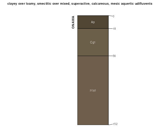
| Onawa silty clay | 146 | 3226 | 406099 | fmkz | ia071 | 1968 | 1:20000 |
Onawa silt loam | 145 | 376 | 406098 | fmky | ia071 | 1968 | 1:20000 |
Onawa silty clay | 146 | 6066 | 406735 | fn7h | ia085 | 1971 | 1:15840 |
Onawa silt loam | 145 | 1134 | 406734 | fn7g | ia085 | 1971 | 1:15840 |
Onawa silty clay, 0 to 2 percent slopes | 146 | 3610 | 409538 | fr4x | ia129 | 1979 | 1:15840 |
Onawa silty clay, 0 to 2 percent slopes, rarely flooded | 146 | 9899 | 447347 | h0hk | ia133 | 1994 | 1:12000 |
Onawa silty clay, 0 to 2 percent slopes, occasionally flooded | 1146 | 2546 | 447404 | h0kd | ia133 | 1994 | 1:12000 |
Onawa silt loam, 0 to 2 percent slopes, rarely flooded | 145 | 797 | 447346 | h0hj | ia133 | 1994 | 1:12000 |
Onawa silt loam, 0 to 2 percent slopes, occasionally flooded | 1145 | 197 | 447403 | h0kc | ia133 | 1994 | 1:12000 |
Onawa silty clay, 0 to 2 percent slopes | 146 | 3790 | 410445 | fs35 | ia155 | 1986 | 1:15840 |
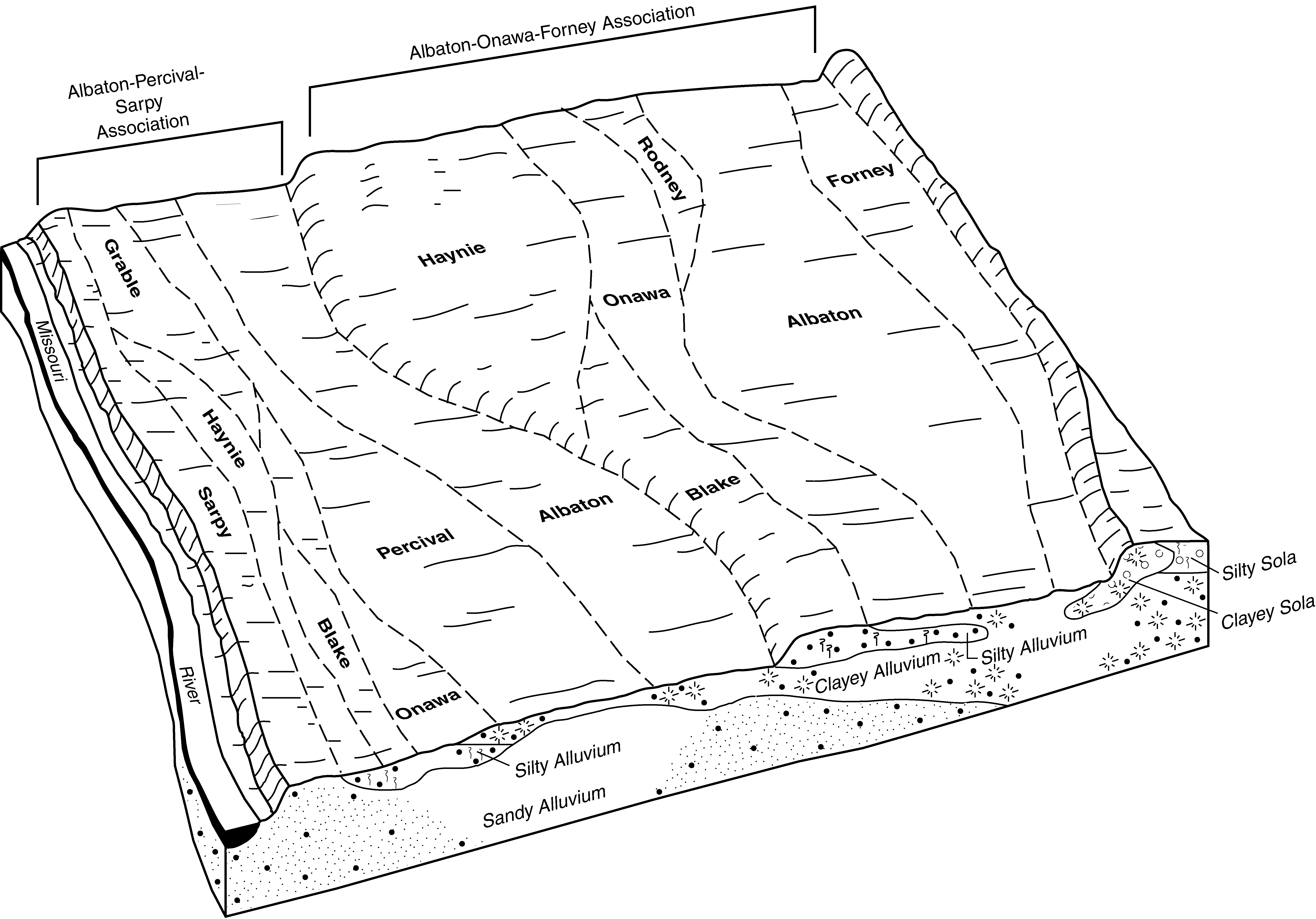
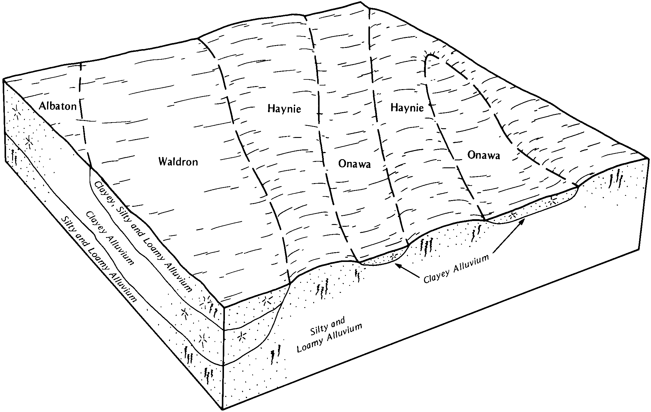
Onawa-Albaton complex, 0 to 2 percent slopes, rarely flooded | 3146 | 4079 | 741626 | swqf | ia193 | 2003 | 1:12000 |
Onawa silty clay, 0 to 2 percent slopes, occasionally flooded | 1146 | 515 | 401827 | fh45 | ia193 | 2003 | 1:12000 |
Onawa and Waldron silty clay loams, occasionally flooded | 7760 | 2971 | 1475384 | 1lj81 | ks005 | 1998 | 1:24000 |
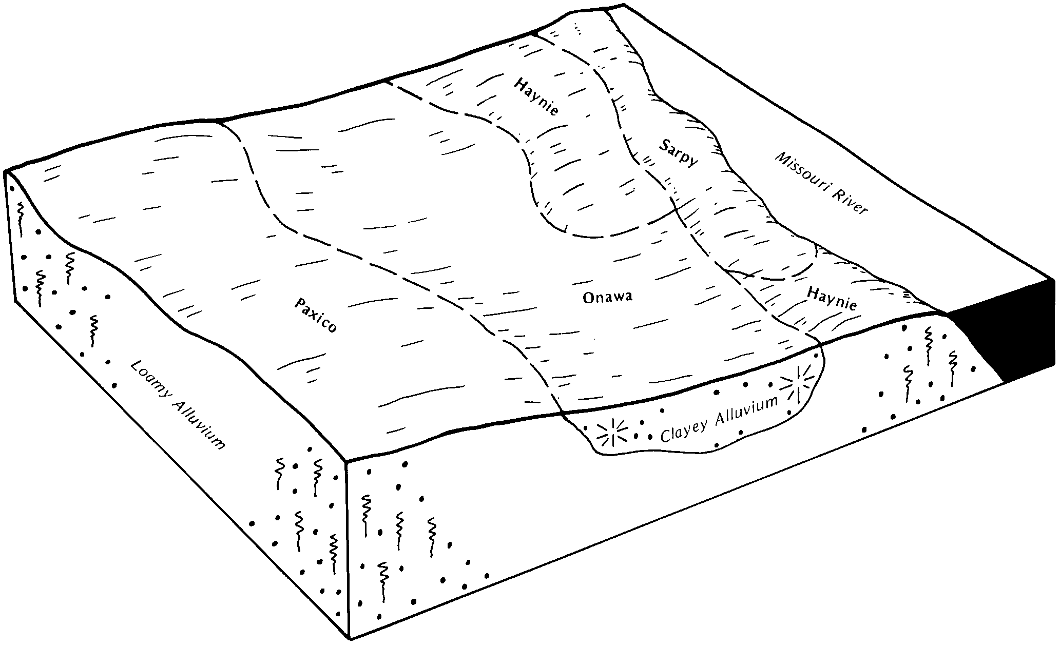
Haynie-Onawa complex, occasionally flooded | 7743 | 1827 | 1475382 | 1lj7z | ks005 | 1998 | 1:24000 |
Onawa loam, overwash, occasionally flooded | 7761 | 286 | 1475385 | 1lj82 | ks005 | 1998 | 1:24000 |
Onawa and Waldron silty clay loams, occasionally flooded | 7760 | 6687 | 747178 | t2hj | ks043 | 1977 | 1:24000 |
Onawa loamy fine sand, overwash, occasionally flooded | 7762 | 5237 | 747179 | t2hk | ks043 | 1977 | 1:24000 |
Haynie-Onawa complex, occasionally flooded | 7743 | 3596 | 747160 | t2gy | ks043 | 1977 | 1:24000 |
Onawa silty clay loam, occasionally flooded | 7763 | 3013 | 1862405 | 20hzl | ks103 | 1973 | 1:24000 |
Onawa soils, occasionally flooded, overwash | 7764 | 2038 | 1862406 | 20hzm | ks103 | 1973 | 1:24000 |
Onawa and Waldron silty clay loams, occasionally flooded | 7760 | 620 | 1862403 | 20hzj | ks103 | 1973 | 1:24000 |
Haynie-Onawa complex, occasionally flooded | 7743 | 154 | 1862402 | 20hzh | ks103 | 1973 | 1:24000 |
Onawa loam, overwash, occasionally flooded | 7761 | 35 | 1862404 | 20hzk | ks103 | 1973 | 1:24000 |
Onawa soils, occasionally flooded, overwash | 7764 | 2823 | 1862294 | 20hw0 | ks209 | 1973 | 1:24000 |
Onawa silty clay loam, occasionally flooded | 7763 | 2164 | 1862293 | 20hvz | ks209 | 1973 | 1:24000 |
Onawa silty clay, 0 to 2 percent slopes, rarely flooded | 13568 | 7067 | 2528458 | 2qmv3 | mo005 | 1988 | 1:24000 |
Onawa silty clay, 0 to 2 percent slopes, frequently flooded | 13567 | 1361 | 902696 | z9b7 | mo005 | 1988 | 1:24000 |
Onawa silty clay, 0 to 2 percent slopes, rarely flooded | 13568 | 9102 | 2528457 | 2qmv3 | mo021 | 1984 | 1:24000 |
Haynie-Onawa complex, 0 to 2 percent slopes, rarely flooded | 13530 | 1291 | 887543 | yskf | mo021 | 1984 | 1:24000 |
Onawa silty clay, 0 to 2 percent slopes, rarely flooded | 13568 | 123 | 2528456 | 2qmv3 | mo165 | 1982 | 1:24000 |
Onawa silty clay, occasionally flooded | 7880 | 504 | 357647 | d050 | ne015 | 1976 | 1:20000 |
Onawa silty clay, occasionally flooded | 7880 | 3927 | 427855 | gc6s | ne021 | 1978 | 1:20000 |
Onawa silty clay, occasionally flooded | 7880 | 2029 | 1691490 | 1ts46 | ne025 | 1981 | 1:20000 |
Onawa silty clay, rarely flooded | 7883 | 2103 | 427122 | gbg4 | ne027 | 1982 | 1:20000 |
Onawa silty clay, occasionally flooded | 7880 | 5783 | 426764 | gb2l | ne043 | 1972 | 1:20000 |
Onawa silty clay, occasionally flooded | 7880 | 2330 | 426694 | gb0b | ne051 | 1975 | 1:20000 |
Onawa silty clay, rarely flooded | 7883 | 219 | 2217069 | 2df1c | ne051 | 1975 | 1:20000 |
Onawa silty clay, occasionally flooded | 7880 | 1840 | 1710962 | 1vfdb | ne055 | 2007 | 1:12000 |
Gilliam-Onawa complex, occasionally flooded | 8486 | 256 | 1710943 | 1vfcq | ne055 | 2007 | 1:12000 |
Onawa silty clay, occasionally flooded, wet | 7762 | 351 | 2570478 | 2rmhw | ne107 | 1989 | 1:20000 |
Onawa silty clay, rarely flooded | 7883 | 39 | 849265 | xhqn | ne107 | 1989 | 1:20000 |
Onawa silty clay, occasionally flooded | 7880 | 4696 | 1691687 | 1tsbk | ne127 | 1983 | 1:20000 |
Onawa silt loam, occasionally flooded | 7877 | 870 | 1691686 | 1tsbj | ne127 | 1983 | 1:20000 |
Onawa silt loam, overwash, occasionally flooded | 7878 | 8 | 2219386 | 2dhg3 | ne127 | 1983 | 1:20000 |
Onawa silty clay, occasionally flooded | 7880 | 2289 | 1691548 | 1ts62 | ne131 | 1979 | 1:20000 |
Onawa silt loam, overwash, occasionally flooded | 7878 | 662 | 1691547 | 1ts61 | ne131 | 1979 | 1:20000 |
Onawa silty clay, occasionally flooded | 7880 | 1305 | 1691061 | 1trpc | ne147 | 1967 | 1:20000 |
Onawa silty clay, occasionally flooded | 7880 | 1498 | 1711025 | 1vfgc | ne153 | 2007 | 1:12000 |
Onawa-Lossing silty clays, occasionally flooded | 7886 | 1071 | 1711026 | 1vfgd | ne153 | 2007 | 1:12000 |
Gilliam-Onawa complex, occasionally flooded | 8486 | 578 | 1711008 | 1vfft | ne153 | 2007 | 1:12000 |
Onawa silty clay, occasionally flooded | 7880 | 1517 | 427742 | gc34 | ne173 | 1966 | 1:20000 |
Onawa and Haynie soils, occasionally flooded | 7876 | 645 | 427741 | gc33 | ne173 | 1966 | 1:20000 |
Onawa silty clay, occasionally flooded | 7880 | 3006 | 395498 | f8k0 | ne177 | 2000 | 1:12000 |
Onawa-Haynie complex, occasionally flooded | 7885 | 1803 | 395515 | f8kk | ne177 | 2000 | 1:12000 |
Onawa silty clay loam, occasionally flooded | 7763 | 1474 | 395513 | f8kh | ne177 | 2000 | 1:12000 |
Onawa silty clay, occasionally flooded, wet | S425A | 891 | 2615589 | 2rmhw | sd023 | 1980 | 1:20000 |
Onawa fine sandy loam, overwash | Oh | 278 | 355056 | cxgf | sd023 | 1980 | 1:20000 |
Onawa silty clay, 0 to 2 percent slopes | Oa | 3393 | 445596 | gyp2 | sd027 | 1995 | 1:24000 |
Haynie-Onawa-Blake complex, 0 to 2 percent slopes | Ho | 2280 | 445579 | gynj | sd027 | 1995 | 1:24000 |
Onawa-Owego silty clays, 0 to 2 percent slopes | Ob | 646 | 445597 | gyp3 | sd027 | 1995 | 1:24000 |
Onawa silty clay | Ob | 6053 | 453714 | h73y | sd127 | 1974 | 1:20000 |
Onawa silty clay | Oa | 1469 | 418096 | g11z | sd135 | 1977 | 1:20000 |