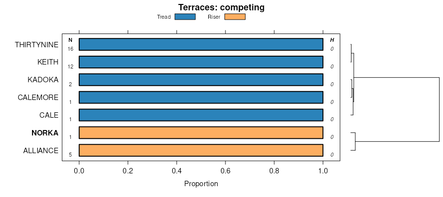
| Ulysses and norka silt loams, 0 to 1 percent slopes | UnA | 18881 | 94217 | 3518 | co009 | 1966 | 1:20000 |
Ulysses and norka silt loams, 1 to 3 percent slopes | UnB | 10853 | 94218 | 3519 | co009 | 1966 | 1:20000 |
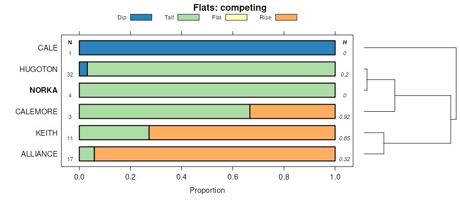
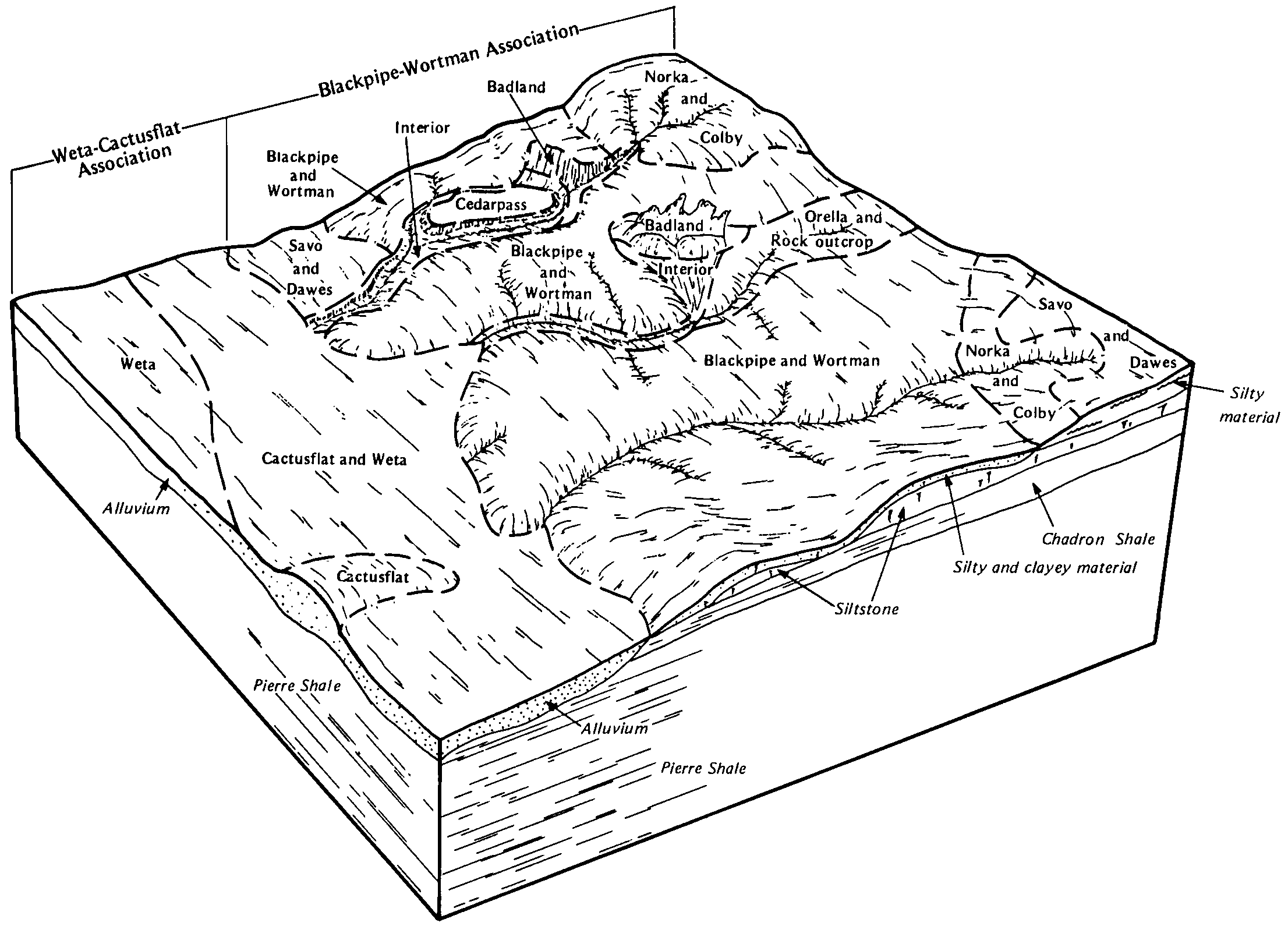
Norka silt loam, 0 to 2 percent slopes | 26 | 90786 | 94435 | 3589 | co061 | 1977 | 1:24000 |
Norka silt loam, 0 to 3 percent slopes | 52 | 124303 | 96851 | 37s7 | co063 | 1996 | 1:24000 |
Weld-Norka silt loams, 0 to 3 percent slopes | 96 | 63320 | 96804 | 37qq | co063 | 1996 | 1:24000 |
Norka-Colby silt loams, 5 to 15 percent slopes | 56 | 58862 | 96849 | 37s5 | co063 | 1996 | 1:24000 |
Norka-Colby silt loams, 3 to 5 percent slopes | 55 | 55000 | 96850 | 2w5dd | co063 | 1996 | 1:24000 |
Norka-Colby-Weld silt loams, 3 to 5 percent slopes | 57 | 25273 | 96859 | 2w5dv | co063 | 1996 | 1:24000 |
Norka-Colby silt loams, 0 to 3 percent slopes | 54 | 19466 | 96852 | 37s8 | co063 | 1996 | 1:24000 |
Norka silt loam, 1 to 3 percent slopes, eroded | 53 | 3195 | 96848 | 37s4 | co063 | 1996 | 1:24000 |
Norka-Ulysses loams, 1 to 3 percent slopes | 75 | 13534 | 94560 | 35db | co075 | 1974 | 1:24000 |
Mitchell-Norka loams, 0 to 3 percent slopes | 71 | 8306 | 94556 | 35d6 | co075 | 1974 | 1:24000 |
Norka loam, 0 to 1 percent slopes | 74 | 1685 | 94559 | 35d9 | co075 | 1974 | 1:24000 |
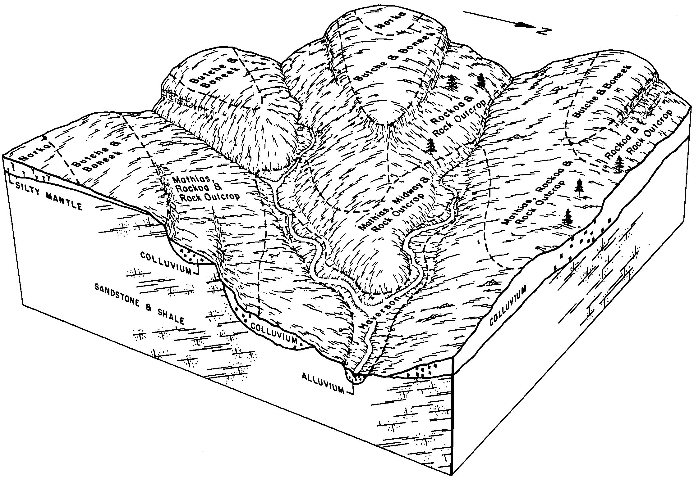
Colby-Norka loams, 5 to 9 percent slopes | 17 | 113826 | 94976 | 35tr | co121 | 1982 | 1:24000 |
Norka-Colby loams, 3 to 5 percent slopes | 47 | 73038 | 95009 | 2w5dc | co121 | 1982 | 1:24000 |
Norka-Colby very fine sandy loams, 3 to 9 percent slopes | 46 | 5007 | 95008 | 35vs | co121 | 1982 | 1:24000 |
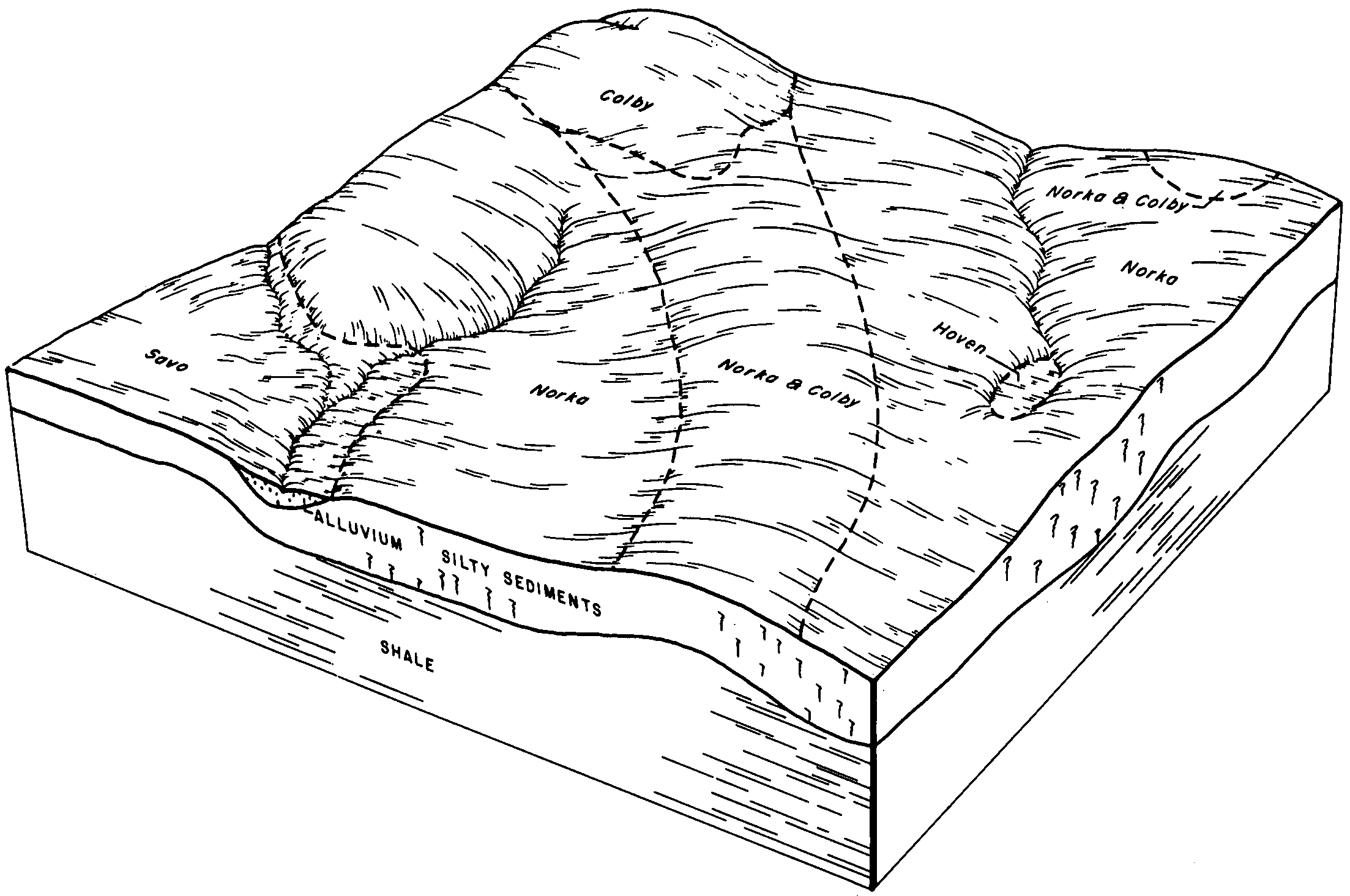
Norka silt loam, 2 to 6 percent slopes | NoB | 18584 | 355129 | 2tvtp | sd047 | 1980 | 1:24000 |
Norka silt loam, 2 to 6 percent slopes | P276B | 4923 | 2733140 | 2rvfg | sd047 | 1980 | 1:24000 |
Norka silt loam, 6 to 9 percent slopes | NoC | 4412 | 355130 | 2y6f5 | sd047 | 1980 | 1:24000 |
Colby-Norka silt loams, 6 to 15 percent slopes | CnD | 4286 | 355098 | 2tvtq | sd047 | 1980 | 1:24000 |
Colby-Norka silt loams, cool, 6 to 15 percent slopes | P080D | 2229 | 2733124 | 30wn1 | sd047 | 1980 | 1:24000 |
Norka silt loam, 0 to 2 percent slopes | NoA | 1064 | 355128 | 2tvtn | sd047 | 1980 | 1:24000 |
Norka silt loam, 6 to 9 percent slopes | P276C | 925 | 2733141 | 2rvfh | sd047 | 1980 | 1:24000 |
Norka silt loam, 0 to 2 percent slopes | P276A | 238 | 2733139 | 2rvff | sd047 | 1980 | 1:24000 |
Colby-Norka silt loams, 6 to 15 percent slopes | CmC | 4977 | 2580886 | 2tvtq | sd606 | 2011 | 1:24000 |
Norka silt loam, 2 to 6 percent slopes | NgB | 3430 | 2580936 | 2tvtp | sd606 | 2011 | 1:24000 |
Norka-Weta silt loams, 0 to 3 percent slopes | NhA | 3245 | 2580937 | cyj9 | sd606 | 2011 | 1:24000 |
Norka silt loam, 0 to 2 percent slopes | NgA | 2862 | 2580935 | 2tvtn | sd606 | 2011 | 1:24000 |
Norka silt loam, 2 to 6 percent slopes | P276B | 40 | 2768142 | 2rvfg | sd607 | 2011 | 1:24000 |
Colby-Norka silt loams, cool, 6 to 15 percent slopes | P080D | 29 | 2768134 | 30wn1 | sd607 | 2011 | 1:24000 |
Norka silt loam, 6 to 9 percent slopes | P276C | 17 | 2768143 | 2rvfh | sd607 | 2011 | 1:24000 |
Norka-Colby silt loams, 6 to 15 percent slopes | NpD | 2575 | 2582644 | cy3b | sd611 | 2011 | 1:24000 |
Norka silt loam, 0 to 2 percent slopes | NoA | 1807 | 2582643 | 2tvtn | sd611 | 2011 | 1:24000 |
Norka-Weta silt loams, 0 to 3 percent slopes | NtA | 81 | 2582677 | 1lm7z | sd611 | 2011 | 1:24000 |
Spangler-Norka loams, 1 to 6 percent slopes | P474B | 2899 | 2745924 | 2rxvp | wy011 | 1978 | 1:24000 |
Spangler-Norka loams, 6 to 10 percent slopes | P474C | 1904 | 2745925 | 2rxvq | wy011 | 1978 | 1:24000 |
Norka loam, 1 to 6 percent slopes | P274B | 1261 | 2745773 | 2rxt7 | wy011 | 1978 | 1:24000 |
Norka loam, 6 to 10 percent slopes | P274C | 1224 | 2745774 | 2rxt8 | wy011 | 1978 | 1:24000 |
Spangler-Norka complex, 1 to 6 percent slopes | 171 | 311 | 349255 | cqf9 | wy011 | 1978 | 1:24000 |
Norka silt loam, 6 to 9 percent slopes | P276C | 14 | 2768199 | 2rvfh | wy045 | 1984 | 1:24000 |
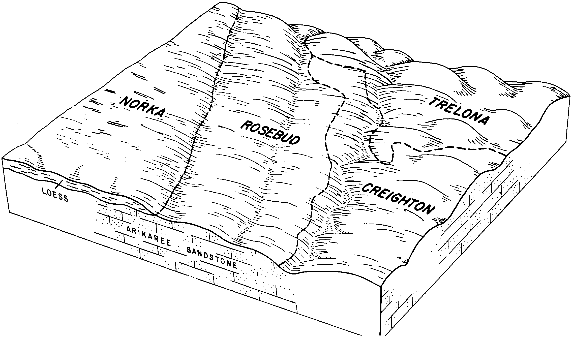
Norka-Weld loams, 0 to 6 percent slopes | NwB | 7463 | 104726 | 3hz8 | wy615 | 1965 | 1:20000 |
Rosebud and Norka loams, 1 to 6 percent slopes | RnB | 6648 | 104739 | 3hzp | wy615 | 1965 | 1:20000 |
Norka and Colby loams, 0 to 6 percent slopes | NrB | 6433 | 104725 | 3hz7 | wy615 | 1965 | 1:20000 |
Rosebud and Norka loams, 6 to 10 percent slopes | RnC | 1956 | 104740 | 3hzq | wy615 | 1965 | 1:20000 |
Norka loam, 1 to 6 percent slopes | NoB | 1454 | 104724 | 3hz6 | wy615 | 1965 | 1:20000 |
Rosebud and Norka loams, 0 to 1 percent slopes | RnA | 1219 | 104738 | 3hzn | wy615 | 1965 | 1:20000 |
Norka loam, 0 to 1 percent slopes | NoA | 872 | 104723 | 3hz5 | wy615 | 1965 | 1:20000 |
Norka-Weld loams, 6 to 10 percent slopes | NwC | 770 | 104727 | 3hz9 | wy615 | 1965 | 1:20000 |
