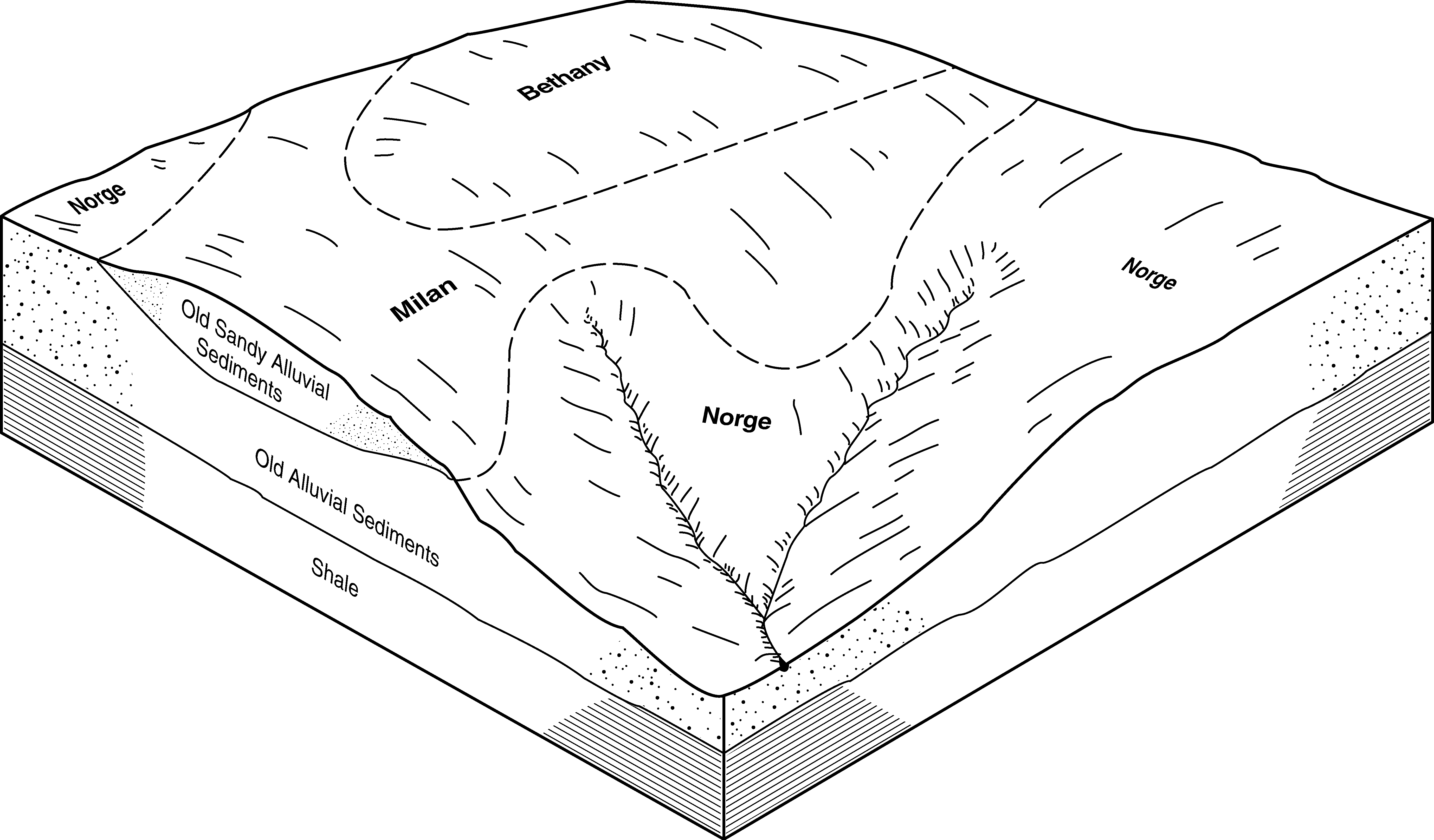
| Norge silt loam, 1 to 3 percent slopes | 6401 | 21697 | 1382894 | 2wtwc | ks015 | 1970 | 1:24000 |
Olpe-Norge complex, 2 to 7 percent slopes | 8859 | 7791 | 1382898 | 2xlh6 | ks015 | 1970 | 1:24000 |
Norge silt loam, 3 to 7 percent slopes | 6402 | 6084 | 1382895 | 2wtwd | ks015 | 1970 | 1:24000 |
Norge silty clay loam, 3 to 7 percent slopes, eroded | 6403 | 4768 | 1382896 | 2wtwf | ks015 | 1970 | 1:24000 |
Norge silt loam, 0 to 1 percent slopes | 6400 | 3064 | 1382893 | 2wtwb | ks015 | 1970 | 1:24000 |
Norge silt loam, 1 to 3 percent slopes | 6401 | 20542 | 1382953 | 2wtwc | ks035 | 1977 | 1:24000 |
Norge silt loam, 3 to 7 percent slopes | 6402 | 7622 | 1382954 | 2wtwd | ks035 | 1977 | 1:24000 |
Norge silty clay loam, 3 to 7 percent slopes, eroded | 6403 | 3484 | 1382955 | 2wtwf | ks035 | 1977 | 1:24000 |
Olpe-Norge complex, 2 to 7 percent slopes | 8859 | 573 | 1382957 | 2xlh6 | ks035 | 1977 | 1:24000 |
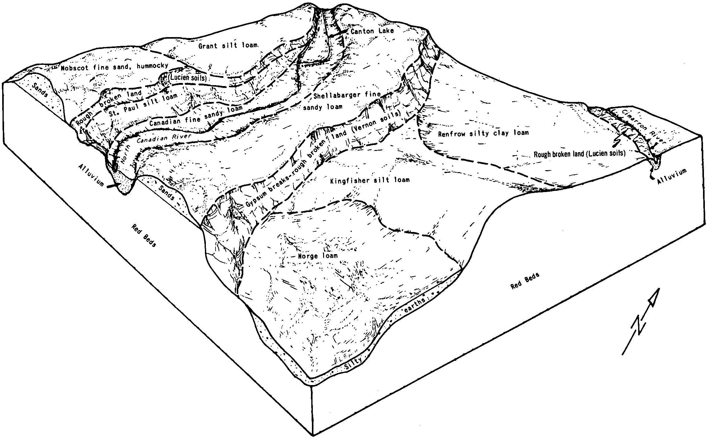
Norge loam, 1 to 3 percent slopes | NoB | 14679 | 381754 | 2tp5b | ok011 | 1965 | 1:24000 |
Norge loam, 0 to 1 percent slopes | NoA | 7565 | 381753 | dt7m | ok011 | 1965 | 1:24000 |
Norge loam, 3 to 5 percent slopes | NoC | 6738 | 381755 | 2tp5c | ok011 | 1965 | 1:24000 |
Norge-Pawhuska complex, 0 to 3 percent slopes | NsA | 5226 | 381757 | dt7r | ok011 | 1965 | 1:24000 |
Norge loam, 5 to 8 percent slopes | NoD | 1197 | 381756 | 2tp5d | ok011 | 1965 | 1:24000 |
Norge silt loam, 3 to 5 percent slopes | NrC | 13279 | 381907 | 2tp4q | ok015 | 1967 | 1:24000 |
Norge silt loam, 1 to 3 percent slopes | NrB | 12536 | 381906 | 2tp4h | ok015 | 1967 | 1:24000 |
Norge silt loam, 1 to 3 percent slopes | NrB | 48631 | 381966 | 2tp4h | ok017 | 1972 | 1:24000 |
Norge silt loam, 3 to 5 percent slopes | NrC | 45945 | 381967 | 2tp4q | ok017 | 1972 | 1:24000 |
Norge silt loam, 5 to 8 percent slopes | NrD | 3655 | 381968 | 2tp4r | ok017 | 1972 | 1:24000 |
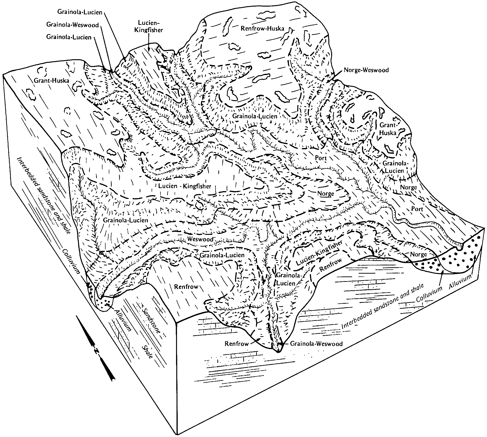
Norge-Ashport silt loams complex, 0 to 8 percent slopes, frequently flooded | 33 | 4763 | 382100 | 30g73 | ok027 | 1984 | 1:24000 |
Norge silt loam, 3 to 5 percent slopes | 82 | 4225 | 382147 | 2tp4q | ok027 | 1984 | 1:24000 |
Norge silt loam, 1 to 3 percent slopes | 81 | 3078 | 382146 | 2tp4h | ok027 | 1984 | 1:24000 |
Norge silt loam, 5 to 8 percent slopes, eroded | 83 | 2992 | 382148 | dtnc | ok027 | 1984 | 1:24000 |
Vanoss-Urban land-Norge complex, 0 to 3 percent slopes | 74 | 1295 | 382138 | dtn1 | ok027 | 1984 | 1:24000 |
Norge silt loam, 5 to 8 percent slopes | 85 | 623 | 382150 | 2tp4r | ok027 | 1984 | 1:24000 |
Norge-Urban land complex, 3 to 8 percent slopes | 86 | 310 | 382151 | dtng | ok027 | 1984 | 1:24000 |
Norge silt loam, 1 to 3 percent slopes | NorB | 229 | 1380057 | 2tp4h | ok031 | 1965 | 1:24000 |
Norge silt loam, 3 to 5 percent slopes | NorC | 192 | 1380056 | 2tp4q | ok031 | 1965 | 1:24000 |
Norge loam, 1 to 3 percent slopes | NoB | 7427 | 382509 | 2tp5b | ok047 | 1965 | 1:24000 |
Norge loam, 3 to 5 percent slopes, eroded | NoC2 | 7009 | 382511 | 2tp5g | ok047 | 1965 | 1:24000 |
Norge loam, 5 to 8 percent slopes, eroded | NoD2 | 3898 | 382513 | dv14 | ok047 | 1965 | 1:24000 |
Norge loam, 3 to 5 percent slopes | NoC | 1480 | 382510 | 2tp5c | ok047 | 1965 | 1:24000 |
Norge loam, 5 to 8 percent slopes | NoD | 895 | 382512 | 2tp5d | ok047 | 1965 | 1:24000 |
Norge silt loam, 1 to 3 percent slopes | 54 | 3441 | 382588 | 2tp4h | ok049 | 1982 | 1:24000 |
Norge silt loam, 0 to 1 percent slopes | 53 | 713 | 382587 | 2rj9w | ok049 | 1982 | 1:24000 |
Norge silt loam, 1 to 3 percent slopes | 34 | 12381 | 382654 | 2tp4h | ok051 | 1975 | 1:24000 |
Norge silt loam, 3 to 5 percent slopes, eroded | 35 | 4847 | 382655 | 2tp4v | ok051 | 1975 | 1:24000 |
Norge silt loam, 0 to 1 percent slopes | 33 | 3754 | 382653 | 2rj9w | ok051 | 1975 | 1:24000 |
Norge silt loam, 3 to 5 percent slopes | 36 | 3024 | 382725 | 2tp4q | ok053 | 1983 | 1:24000 |
Norge silt loam, 3 to 5 percent slopes, eroded | 37 | 1291 | 382726 | 2tp4v | ok053 | 1983 | 1:24000 |
Norge silt loam, 1 to 3 percent slopes | NorB | 93 | 623481 | 2tp4h | ok071 | 1965 | 1:24000 |
Norge silt loam, 3 to 5 percent slopes | NorC | 88 | 623482 | 2tp4q | ok071 | 1965 | 1:24000 |
Norge silt loam, 3 to 5 percent slopes, eroded | NorC2 | 23 | 623483 | 2tp4v | ok071 | 1965 | 1:24000 |
Norge loam, 1 to 3 percent slopes | NoB | 836 | 383519 | 2tp5b | ok081 | 1966 | 1:24000 |
Norge loam, 3 to 5 percent slopes | NoC | 525 | 383520 | 2tp5c | ok081 | 1966 | 1:24000 |
Norge loam, 3 to 5 percent slopes, eroded | NoC2 | 375 | 383521 | 2tp5g | ok081 | 1966 | 1:24000 |
Norge silt loam, 3 to 5 percent slopes, eroded | NorC2 | 8380 | 383660 | 2tp4v | ok083 | 1994 | 1:12000 |
Norge silt loam, 1 to 3 percent slopes | NorB | 3705 | 383659 | 2tp4h | ok083 | 1994 | 1:12000 |
Norge silt loam, 0 to 1 percent slopes | NorA | 583 | 383658 | 2rj9w | ok083 | 1994 | 1:12000 |
Norge silt loam, 1 to 3 percent slopes | 44 | 854 | 383951 | 2tp4h | ok099 | 1982 | 1:24000 |
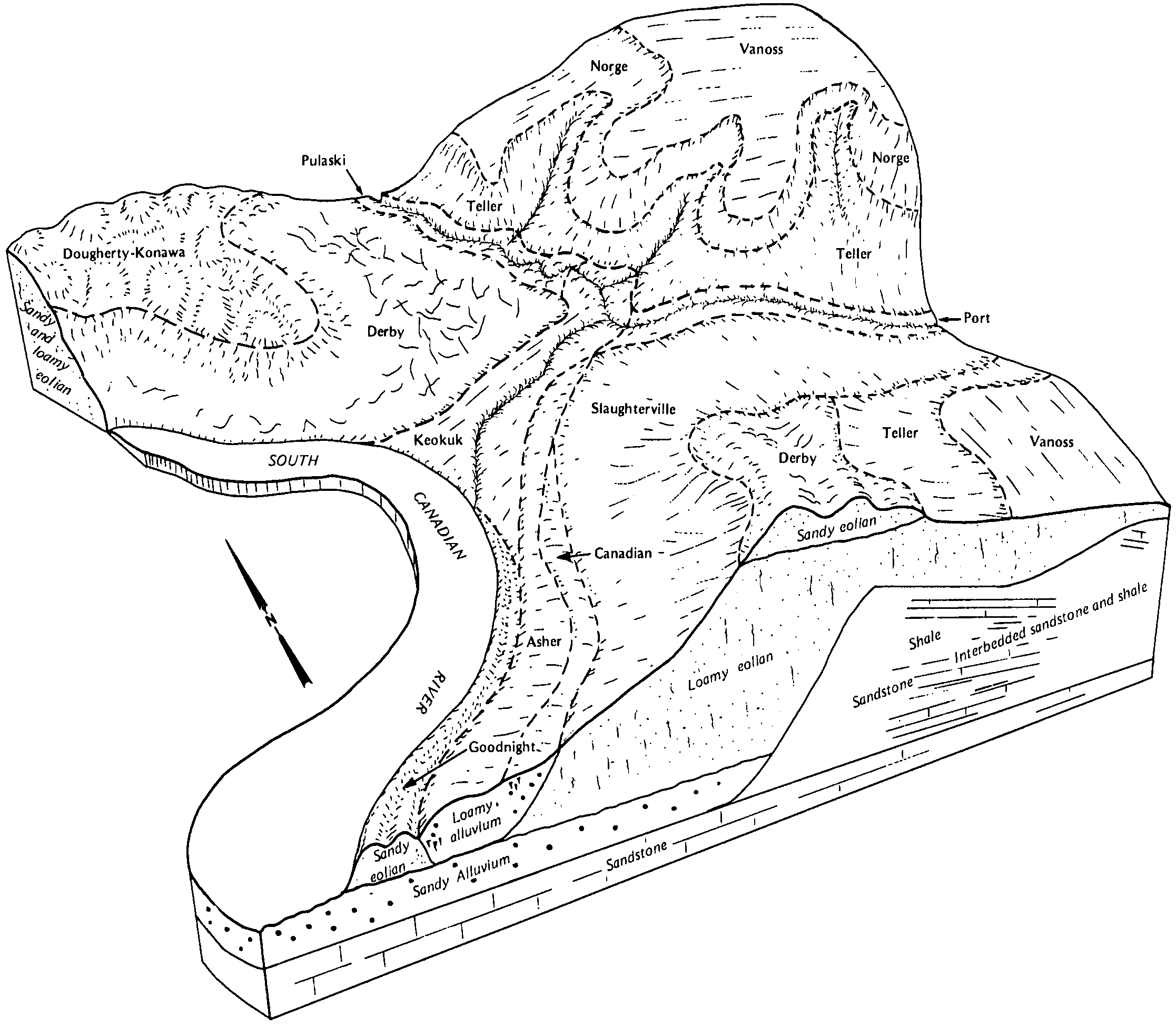
Norge silt loam, 1 to 3 percent slopes | NorB | 25658 | 384095 | 2tp4h | ok103 | 1994 | 1:24000 |
Norge silt loam, 3 to 5 percent slopes, eroded | NorC2 | 13820 | 384097 | 2tp4v | ok103 | 1994 | 1:24000 |
Norge silt loam, 3 to 5 percent slopes | NorC | 7460 | 384096 | 2tp4q | ok103 | 1994 | 1:24000 |
Milan-Pawhuska-Norge complex, 3 to 5 percent slopes, eroded | MPNC2 | 4802 | 384081 | dwnq | ok103 | 1994 | 1:24000 |
Norge-Urban land complex, 1 to 5 percent slopes | NoUC | 1172 | 384093 | 2tp4t | ok103 | 1994 | 1:24000 |
Norge silt loam, 0 to 1 percent slopes | NorA | 1137 | 384094 | 2rj9w | ok103 | 1994 | 1:24000 |
Norge-Urban land complex, 1 to 5 percent slopes | NoUC | 6689 | 384337 | 2tp4t | ok109 | 1996 | 1:12000 |
Norge silt loam, 1 to 3 percent slopes | NorB | 2003 | 384338 | 2tp4h | ok109 | 1996 | 1:12000 |
Norge silt loam, 3 to 5 percent slopes, eroded | NorC2 | 1235 | 384340 | 2tp4v | ok109 | 1996 | 1:12000 |
Norge silt loam, 3 to 5 percent slopes | NorC | 1142 | 384339 | 2tp4q | ok109 | 1996 | 1:12000 |
Norge-Pawhuska complex, 1 to 5 percent slopes | 43 | 16568 | 623438 | nxqx | ok113 | 1975 | 1:24000 |
Norge silt loam, 3 to 5 percent slopes | 39 | 10611 | 623434 | 2tp4q | ok113 | 1975 | 1:24000 |
Norge silt loam, 1 to 3 percent slopes | 38 | 5923 | 623433 | 2tp4h | ok113 | 1975 | 1:24000 |
Norge silt loam, 3 to 5 percent slopes, eroded | 41 | 5242 | 623436 | 2tp4v | ok113 | 1975 | 1:24000 |
Norge, Agra, and Prue soils, 3 to 8 percent slopes, gullied | 42 | 1760 | 623437 | 2yhf9 | ok113 | 1975 | 1:24000 |
Norge silt loam, 5 to 8 percent slopes | 40 | 1238 | 623435 | 2tp4r | ok113 | 1975 | 1:24000 |
Norge silt loam, 1 to 3 percent slopes | NorB | 6978 | 1423181 | 2tp4h | ok117 | 2007 | 1:24000 |
Norge silt loam, 3 to 5 percent slopes, eroded | NorC2 | 6538 | 1412998 | 2tp4v | ok117 | 2007 | 1:24000 |
Norge silt loam, 3 to 5 percent slopes | NorC | 4535 | 1423178 | 2tp4q | ok117 | 2007 | 1:24000 |
Milan-Pawhuska-Norge complex, 3 to 5 percent slopes, eroded | MPNC2 | 120 | 1910057 | 223kr | ok117 | 2007 | 1:24000 |
Norge loam, 1 to 3 percent slopes | NogB | 32 | 1901762 | 2tp5b | ok117 | 2007 | 1:24000 |
Norge loam, 3 to 5 percent slopes, eroded | NogC2 | 23 | 1901764 | 2tp5g | ok117 | 2007 | 1:24000 |
Norge loam, 3 to 5 percent slopes | NogC | 19 | 1901763 | 2tp5c | ok117 | 2007 | 1:24000 |
Norge loam, 3 to 5 percent slopes, eroded | 35 | 7326 | 384532 | 2tp5g | ok119 | 1983 | 1:24000 |
Norge loam, 1 to 3 percent slopes | 33 | 5024 | 384530 | 2tp5b | ok119 | 1983 | 1:24000 |
Norge loam, 3 to 5 percent slopes | 34 | 2758 | 384531 | 2tp5c | ok119 | 1983 | 1:24000 |
Norge-Urban land complex, 1 to 5 percent slopes | 16 | 1229 | 384511 | 2tp4t | ok119 | 1983 | 1:24000 |
Norge loam, 1 to 3 percent slopes | 31 | 1370 | 384692 | 2tp5b | ok125 | 1975 | 1:24000 |
Norge loam, 3 to 5 percent slopes | 32 | 1066 | 384693 | 2tp5c | ok125 | 1975 | 1:24000 |


