Official Series Description


Lab Data Summary

Aggregate lab data for the NOLIN soil series. This aggregation is based on all pedons with a current taxon name of NOLIN, and applied along 1-cm thick depth slices. Solid lines are the slice-wise median, bounded on either side by the interval defined by the slice-wise 5th and 95th percentiles. The median is the value that splits the data in half. Five percent of the data are less than the 5th percentile, and five percent of the data are greater than the 95th percentile. Values along the right hand side y-axis describe the proportion of pedon data that contribute to aggregate values at this depth. For example, a value of "90%" at 25cm means that 90% of the pedons correlated to NOLIN were used in the calculation. Source: KSSL snapshot . Methods used to assemble the KSSL snapshot used by SoilWeb / SDE

Click the image to view it full size.

Pedons used in the lab summary:

MLRALab IDPedon IDTaxonnameCINSSL / NASIS ReportsLink To SoilWeb GMap
114ACL77261977IN021026Nolin3Primary | Supplementary | Taxonomy | Pedon | Water Retention | Correlation | Andic Soil Properties39.4437972,-86.9895028
114A90P055090IN119011Nolin5Primary | Supplementary | Taxonomy | Pedon | Water Retention | Correlation | Andic Soil Properties39.1680565,-86.8777771
115AKX75051975IN083005Nolin2Primary | Supplementary | Taxonomy | Pedon | Water Retention | Correlation | Andic Soil Properties38.8174778,-87.217675
115APS76021976IN129002Nolin2Primary | Supplementary | Taxonomy | Pedon | Water Retention | Correlation | Andic Soil Properties37.9732778,-87.9969111
115APK79071979IN125007Nolin3Primary | Supplementary | Taxonomy | Pedon | Water Retention | Correlation | Andic Soil Properties38.5071639,-87.2796389
115AGN80181980IN055018Nolin3Primary | Supplementary | Taxonomy | Pedon | Water Retention | Correlation | Andic Soil Properties38.9411472,-87.0650472
115AGB82011982IN051001Nolin3Primary | Supplementary | Taxonomy | Pedon | Water Retention | Correlation | Andic Soil Properties38.4975861,-87.5349583
115AGB82022013IN051001Nolin3Primary | Supplementary | Taxonomy | Pedon | Water Retention | Correlation | Andic Soil Properties38.4770139,-87.5919028
115BM87073081987MO073008Nolin3Primary | Supplementary | Taxonomy | Pedon | Water Retention | Correlation | Andic Soil Properties38.9672203,-92.3450012
115BM88215121988MO215012Nolin4Primary | Supplementary | Taxonomy | Pedon | Water Retention | Correlation | Andic Soil Properties38.9672203,-92.3450012
115BM90105011990MO105001Nolin4Primary | Supplementary | Taxonomy | Pedon | Water Retention | Correlation | Andic Soil Properties38.9672203,-92.3450012
115BM90105161990MO105016Nolin4Primary | Supplementary | Taxonomy | Pedon | Water Retention | Correlation | Andic Soil Properties38.9672203,-92.3450012
115BM90151121990MO151012Nolin4Primary | Supplementary | Taxonomy | Pedon | Water Retention | Correlation | Andic Soil Properties38.9672203,-92.3450012
115BM90151131990MO151013Nolin4Primary | Supplementary | Taxonomy | Pedon | Water Retention | Correlation | Andic Soil Properties38.9672203,-92.3450012
115BM91151151991MO151015Nolin4Primary | Supplementary | Taxonomy | Pedon | Water Retention | Correlation | Andic Soil Properties38.9672203,-92.3450012
115BM91151241991MO151024Nolin4Primary | Supplementary | Taxonomy | Pedon | Water Retention | Correlation | Andic Soil Properties38.9672203,-92.3450012
115BM92151231992MO151023Nolin4Primary | Supplementary | Taxonomy | Pedon | Water Retention | Correlation | Andic Soil Properties38.9672203,-92.3450012
115BM92151391992MO151039Nolin4Primary | Supplementary | Taxonomy | Pedon | Water Retention | Correlation | Andic Soil Properties38.9672203,-92.3450012
115BM92221041992MO221004Nolin4Primary | Supplementary | Taxonomy | Pedon | Water Retention | Correlation | Andic Soil Properties38.9672203,-92.3450012
115BM93059181993MO059018Nolin2Primary | Supplementary | Taxonomy | Pedon | Water Retention | Correlation | Andic Soil Properties38.9672203,-92.3450012
115BM90151101995MO151037Nolin4Primary | Supplementary | Taxonomy | Pedon | Water Retention | Correlation | Andic Soil Properties38.514494,-91.6306994
115BM90151111995MO151050Nolin4Primary | Supplementary | Taxonomy | Pedon | Water Retention | Correlation | Andic Soil Properties38.5136606,-91.6601448
116AM90105481990MO105158Nolin4Primary | Supplementary | Taxonomy | Pedon | Water Retention | Correlation | Andic Soil Properties37.5588889,-92.8
116AM94125121994MO125012Nolin4Primary | Supplementary | Taxonomy | Pedon | Water Retention | Correlation | Andic Soil Properties38.0875,-91.6486111111111
116AM96125361996MO125036Nolin4Primary | Supplementary | Taxonomy | Pedon | Water Retention | Correlation | Andic Soil Properties38.2650933,-91.8626191
116AM96125371996MO125037Nolin4Primary | Supplementary | Taxonomy | Pedon | Water Retention | Correlation | Andic Soil Properties38.2634853,-91.8274388
116AM97131161997MO131053Nolin4Primary | Supplementary | Taxonomy | Pedon | Water Retention | Correlation | Andic Soil Properties38.2105942,-92.53156
120A67KY-085-0052013KY085001Nolin4Primary | Supplementary | Taxonomy | Pedon | Water Retention | Correlation | Andic Soil Properties37.5146028,-86.5490028
120A70KY-177-05770KY177057Nolin4Primary | Supplementary | Taxonomy | Pedon | Water Retention | Correlation | Andic Soil Properties37.3200556,-86.9869444
120A70KY-177-05870KY177058Nolin4Primary | Supplementary | Taxonomy | Pedon | Water Retention | Correlation | Andic Soil Properties37.2358806,-86.9188944
120A70KY-225-00270KY225002Nolin4Primary | Supplementary | Taxonomy | Pedon | Water Retention | Correlation | Andic Soil Properties37.7183876,-88.073082
120A71KY-047-05171KY-047-051Nolin4Primary | Supplementary | Taxonomy | Pedon | Water Retention | Correlation | Andic Soil Properties36.8988472,-87.5410111
120BMT80032013IN101001Nolin3Primary | Supplementary | Taxonomy | Pedon | Water Retention | Correlation | Andic Soil Properties38.6420972,-86.8876583
120CWS80022013IN175001Nolin3Primary | Supplementary | Taxonomy | Pedon | Water Retention | Correlation | Andic Soil Properties38.7348444,-86.2899778
121RI79061979IN137006Nolin3Primary | Supplementary | Taxonomy | Pedon | Water Retention | Correlation | Andic Soil Properties38.9673917,-85.1458806
12199KY-015-00199KY-015-001Nolin2Primary | Supplementary | Taxonomy | Pedon | Water Retention | Correlation | Andic Soil Properties38.9222679,-84.8688126
12271KY-047-05071KY-047-050Nolin4Primary | Supplementary | Taxonomy | Pedon | Water Retention | Correlation | Andic Soil Properties36.7982306,-87.5147806
12271KY-093-00471KY-093-004Nolin4Primary | Supplementary | Taxonomy | Pedon | Water Retention | Correlation | Andic Soil Properties37.7084278,-85.8278556
12207N0467S2007-TN-161-6Nolin7Primary | Supplementary | Taxonomy | Pedon | Water Retention | Correlation | Andic Soil Properties36.5105553,-87.9337463
12501KY-129-00101KY-129-001Nolin2Primary | Supplementary | Taxonomy | Pedon | Water Retention | Correlation | Andic Soil Properties37.5889549,-83.6632233
12589KY-053-00489KY-053-004Nolin4Primary | Supplementary | Taxonomy | Pedon | Water Retention | Correlation | Andic Soil Properties36.6973038,-85.0779877
12600P115599OH053248Nolin6Primary | Supplementary | Taxonomy | Pedon | Water Retention | Correlation | Andic Soil Properties38.5939178,-82.2124481
14774PA0270971974PA027097Nolin3Primary | Supplementary | Taxonomy | Pedon | Water Retention | Correlation | Andic Soil Properties40.8233333,-77.8388889
n/aBT-0071975-OH013-007Nolin3Primary | Supplementary | Taxonomy | Pedon | Water Retention | Correlation | Andic Soil Propertiesn/a
n/a71KY-093-00571KY-093-005Nolin4Primary | Supplementary | Taxonomy | Pedon | Water Retention | Correlation | Andic Soil Propertiesn/a
n/a80KY-161-00380KY-161-003Nolin4Primary | Supplementary | Taxonomy | Pedon | Water Retention | Correlation | Andic Soil Propertiesn/a
n/a92P0245S1991OH131103Nolin6Primary | Supplementary | Taxonomy | Pedon | Water Retention | Correlation | Andic Soil Propertiesn/a

Water Balance

Monthly water balance estimated using a leaky-bucket style model for the NOLIN soil series. Monthly precipitation (PPT) and potential evapotranspiration (PET) have been estimated from the 50th percentile of gridded values (PRISM 1981-2010) overlapping with the extent of SSURGO map units containing each series as a major component. Monthly PET values were estimated using the method of Thornthwaite (1948). These (and other) climatic parameters are calculated with each SSURGO refresh and provided by the fetchOSD function of the soilDB package. Representative water storage values (“AWC” in the figures) were derived from SSURGO by taking the 50th percentile of profile-total water storage (sum[awc_r * horizon thickness]) for each soil series. Note that this representation of “water storage” is based on the average ability of most plants to extract soil water between 15 bar (“permanent wilting point”) and 1/3 bar (“field capacity”) matric potential. Soil moisture state can be roughly interpreted as “dry” when storage is depleted, “moist” when storage is between 0mm and AWC, and “wet” when there is a surplus. Clearly there are a lot of assumptions baked into this kind of monthly water balance. This is still a work in progress.

Click the image to view it full size.


Click the image to view it full size.

Sibling Summary

Siblings are those soil series that occur together in map units, in this case with the NOLIN series. Sketches are arranged according to their subgroup-level taxonomic structure. Source: SSURGO snapshot , parsed OSD records and snapshot of SC database .

Click the image to view it full size.

Select annual climate data summaries for the NOLIN series and siblings. Series are sorted according to hierarchical clustering of median values. Source: SSURGO map unit geometry and 1981-2010, 800m PRISM data .

Click the image to view it full size.

Geomorphic description summaries for the NOLIN series and siblings. Series are sorted according to hierarchical clustering of proportions and relative hydrologic position within an idealized landform (e.g. top to bottom). Most soil series (SSURGO components) are associated with a hillslope position and one or more landform-specific positions: hills, mountain slopes, terraces, and/or flats. Proportions can be interpreted as an aggregate representation of geomorphic membership. The values printed to the left (number of component records) and right (Shannon entropy) of stacked bars can be used to judge the reliability of trends. Small Shannon entropy values suggest relatively consistent geomorphic association, while larger values suggest lack thereof. Source: SSURGO component records .

Click the image to view it full size.

Click the image to view it full size.

Click the image to view it full size.

Click the image to view it full size.

Click the image to view it full size.

Competing Series

Soil series competing with NOLIN share the same family level classification in Soil Taxonomy. Source: parsed OSD records and snapshot of the SC database .

Click the image to view it full size.

Select annual climate data summaries for the NOLIN series and competing. Series are sorted according to hierarchical clustering of median values. Source: SSURGO map unit geometry and 1981-2010, 800m PRISM data .

Click the image to view it full size.

Geomorphic description summaries for the NOLIN series and competing. Series are sorted according to hierarchical clustering of proportions and relative hydrologic position within an idealized landform (e.g. top to bottom). Proportions can be interpreted as an aggregate representation of geomorphic membership. Most soil series (SSURGO components) are associated with a hillslope position and one or more landform-specific positions: hills, mountain slopes, terraces, and/or flats. The values printed to the left (number of component records) and right (Shannon entropy) of stacked bars can be used to judge the reliability of trends. Shannon entropy values close to 0 represent soil series with relatively consistent geomorphic association, while values close to 1 suggest lack thereof. Source: SSURGO component records .

Click the image to view it full size.

There are insufficient data to create the 3D hills figure.

There are insufficient data to create the 3D mountains figure.

Click the image to view it full size.

There are insufficient data to create the 3D flats position figure.

Soil series sharing subgroup-level classification with NOLIN, arranged according to family differentiae. Hovering over a series name will print full classification and a small sketch from the OSD. Source: snapshot of SC database .

Block Diagrams

Click a link below to display the diagram. Note that these diagrams may be from multiple survey areas.

  1. =HYPERLINK(CONCATENATE(M51,E51)) | Mammoth Cave National Park - 2010

    Typical pattern of soils and underlying material in the Wallen-Caneyville-Bledsoe general soil map unit (Soil Survey of Mammoth Cave National Park, Kentucky; 2010).

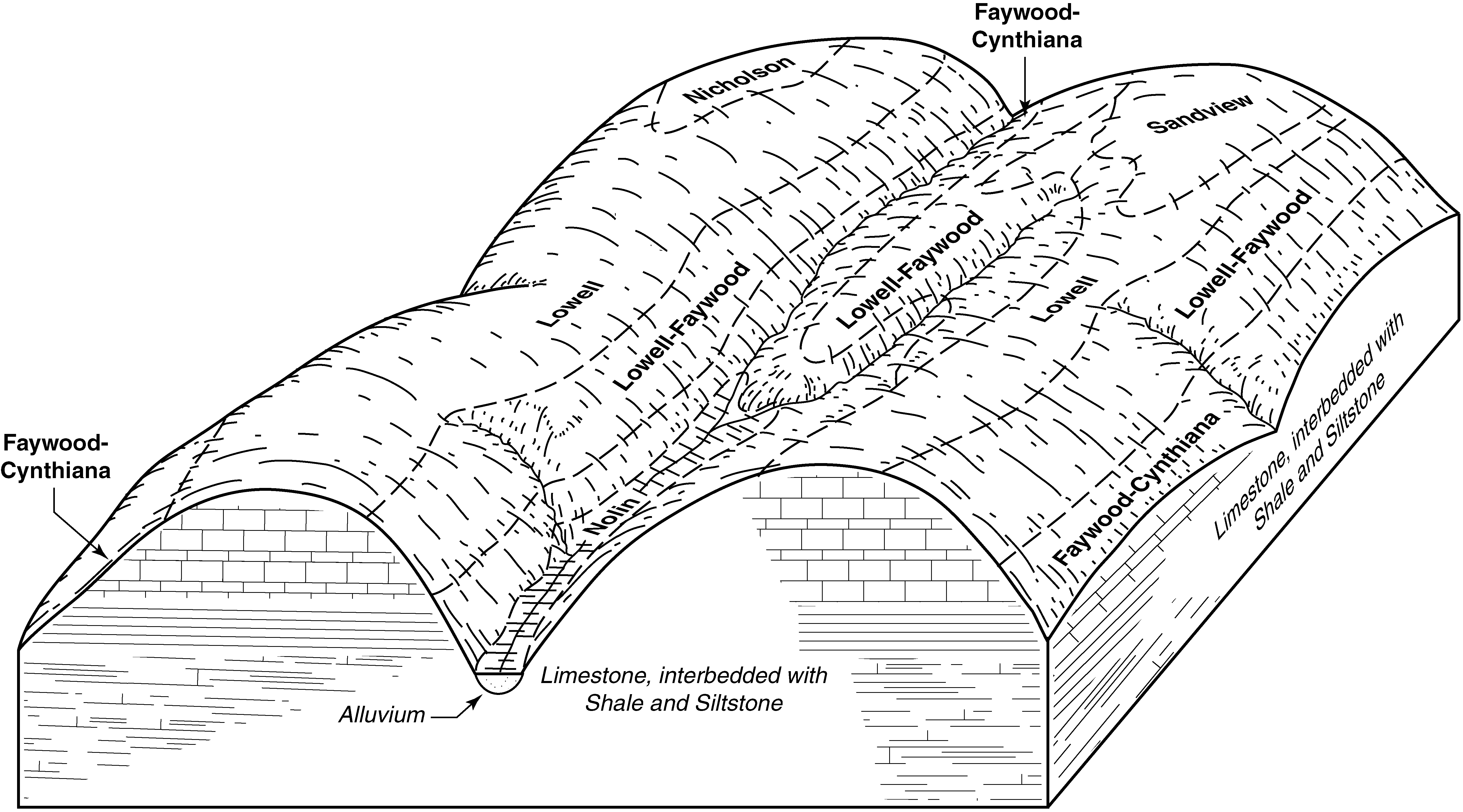
  2. KY-2010-09-03-05 | Garrard and Lincoln Counties - 2006

    Typical pattern of soils and underlying material in the Lowell-Faywood-Cynthiana general soil map unit (Soil Survey of Garrard and Lincoln Counties, Kentucky; 2006).

  3. KY-2010-09-03-06 | Garrard and Lincoln Counties - 2006

    Typical pattern of soils and underlying material in the Shrouts-Beasley-Garlin general soil map unit (Soil Survey of Garrard and Lincoln Counties, Kentucky; 2006).

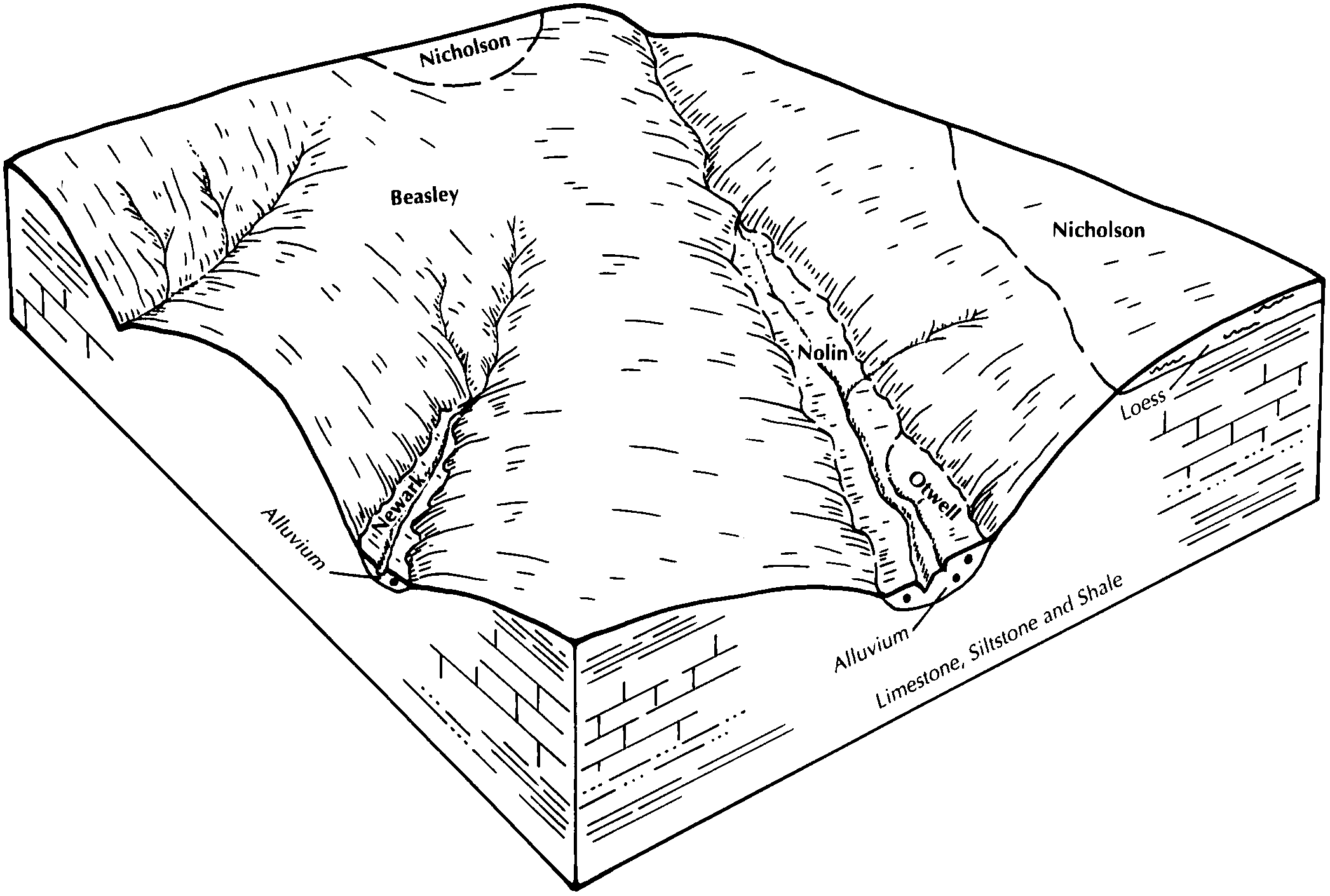
  4. KY-2010-09-03-08 | Garrard and Lincoln Counties - 2006

    Typical pattern of soils and underlying material in the Newark-Nolin-Yosemite general soil map unit (Soil Survey of Garrard and Lincoln Counties, Kentucky; 2006).

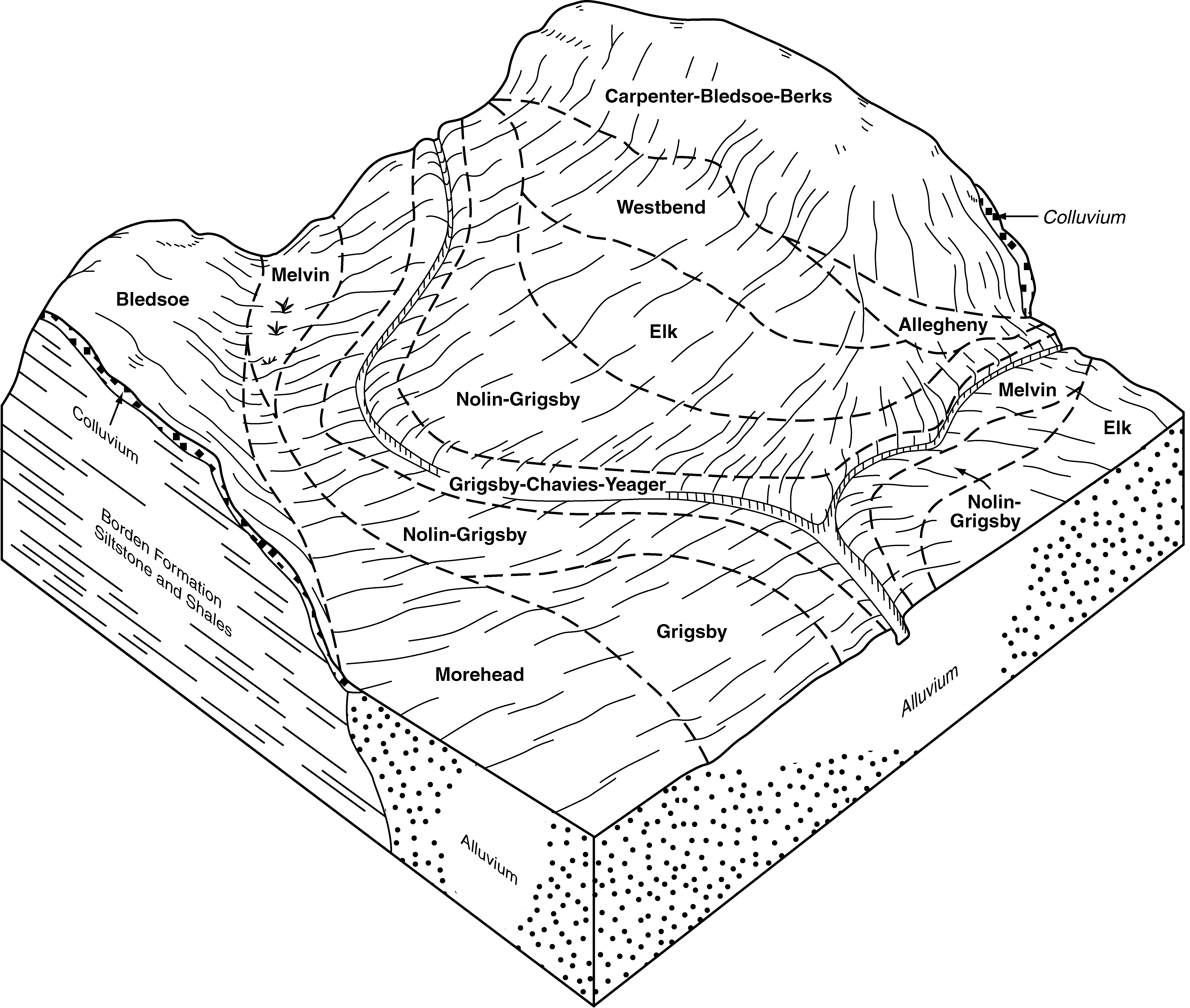
  5. KY-2010-09-03-30 | Estill and Lee Counties - 2007

    Typical pattern of soils and their relationship to geology and topography in the Grigsby-Nolin-Elk-Morehead general soil map unit in Estill County (Soil Survey of Estill and Lee Counties, Kentucky; 2007).

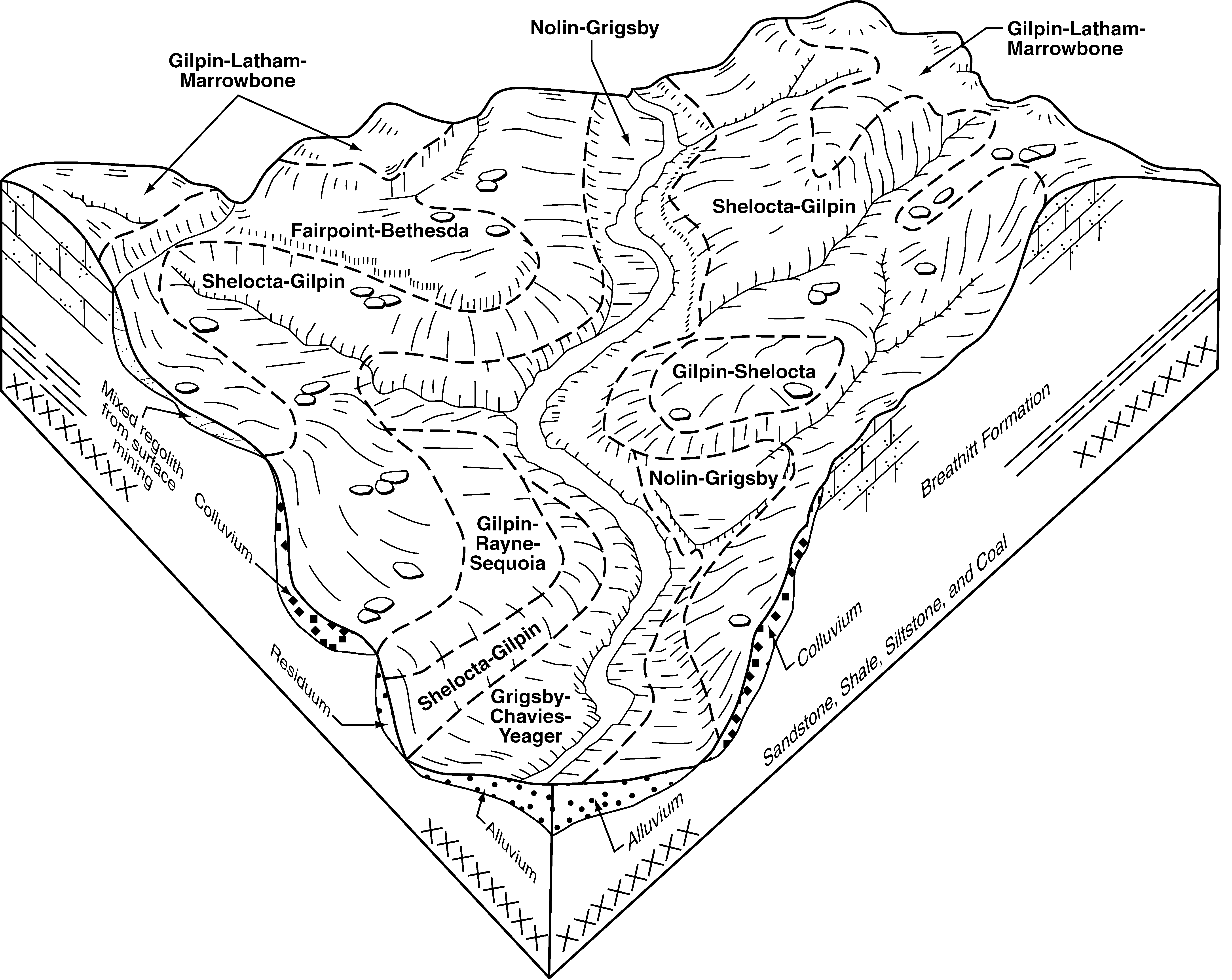
  6. KY-2010-09-03-36 | Estill and Lee Counties - 2007

    Typical pattern of soils and their relationship to geology and topography in the Shelocta-Gilpin general soil map unit in Lee County (Soil Survey of Estill and Lee Counties, Kentucky; 2007).

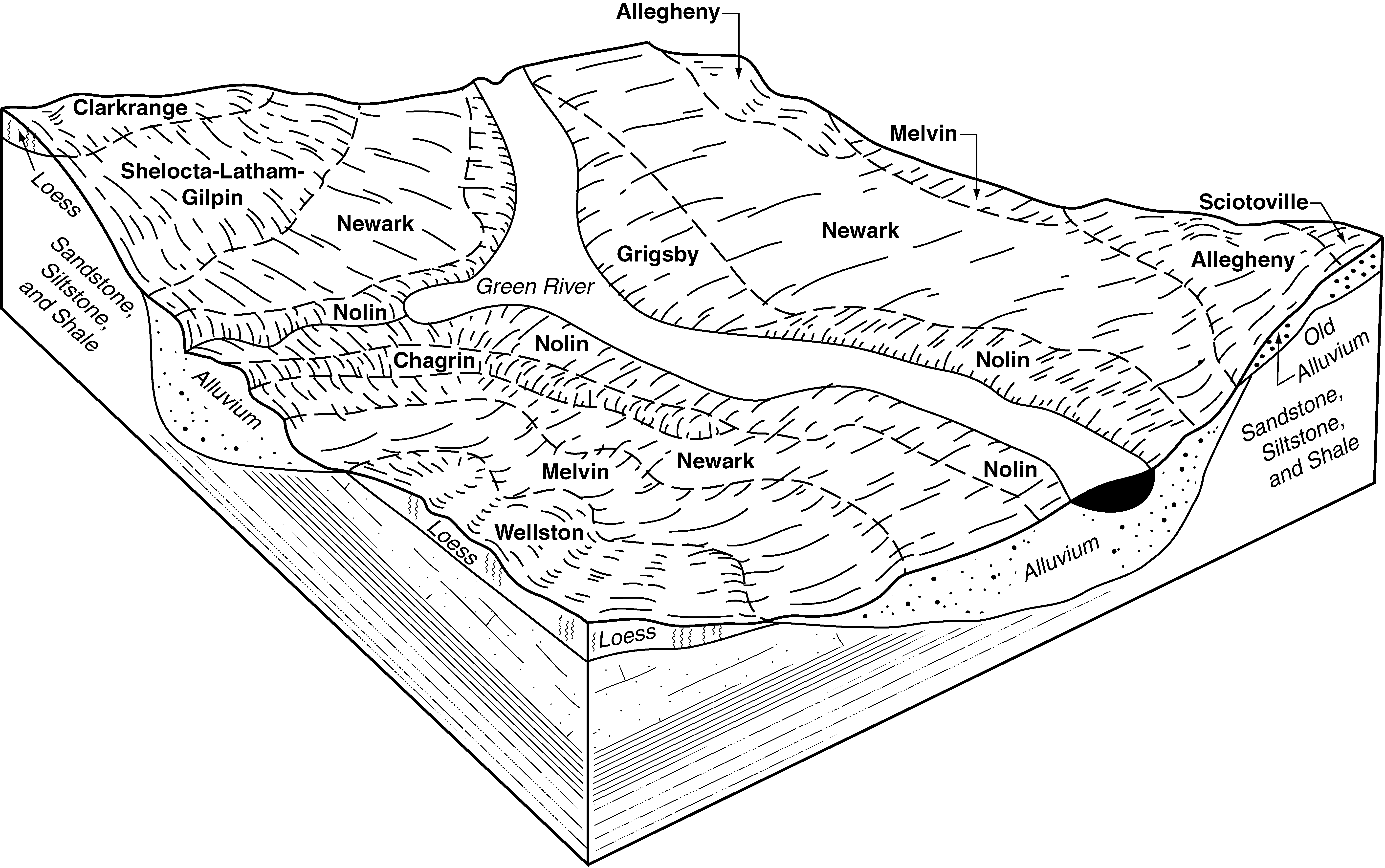
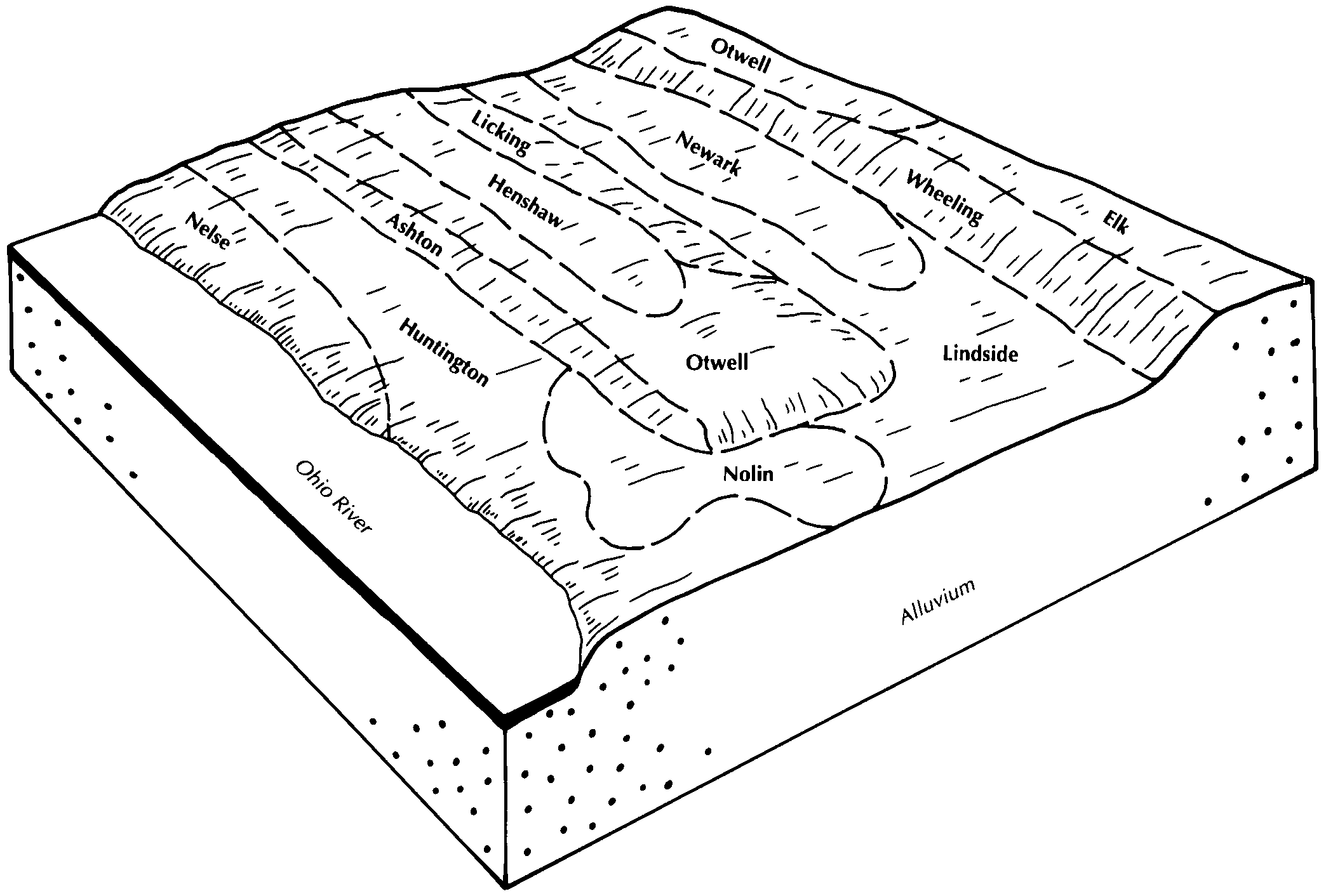
  7. KY-2010-09-10-02 | Butler and Edmonson Counties -

    Relationship of soils to topography and underlying material in the Newark-Nolin-Melvin association (Soil Survey of Butler and Edmonson Counties, Kentucky).

  8. KY-2010-09-10-09 | Butler and Edmonson Counties -

    Relationship of soils to topography and underlying material in the Clarkrange-Wellston association (Soil Survey of Butler and Edmonson Counties, Kentucky).

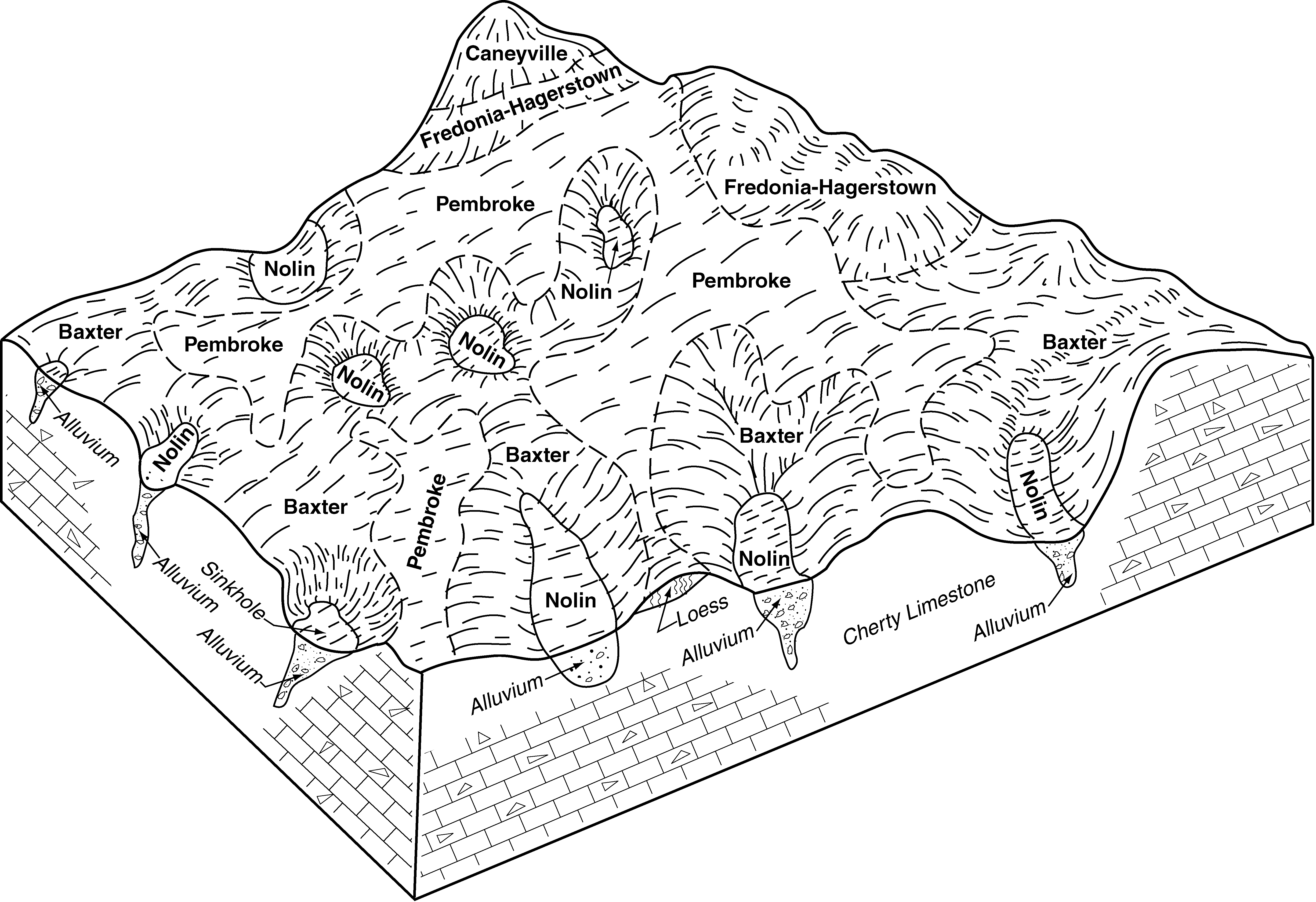
  9. KY-2010-09-10-12 | Butler and Edmonson Counties -

    Relationship of soils to topography and underlying material in the Baxter-Pembroke-Fredonia association (Soil Survey of Butler and Edmonson Counties, Kentucky).

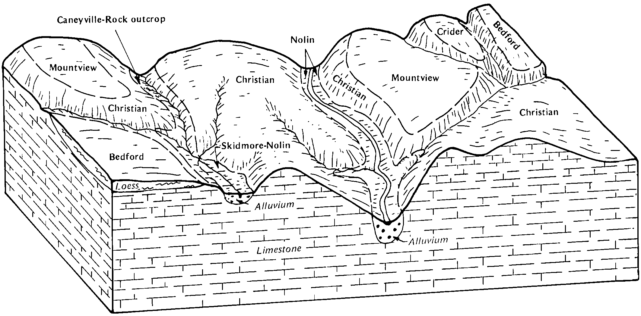
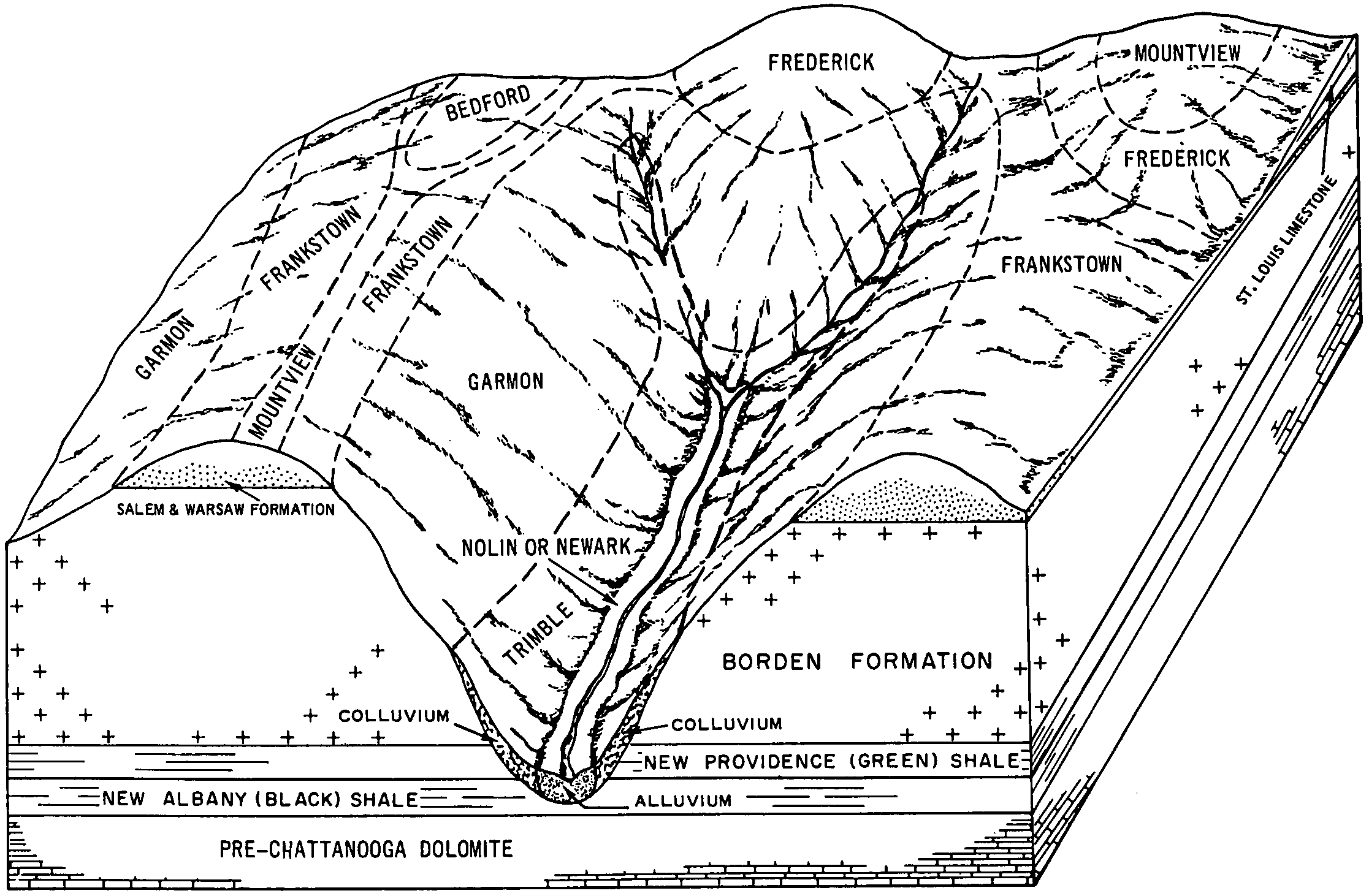
  10. KY-2012-01-26-07 | Allen County - September 1989

    Relationship of soils to topography and underlying material in the Christian-Mountview-Bedford general soil map unit (Soil Survey of Allen County, Kentucky; September 1989).

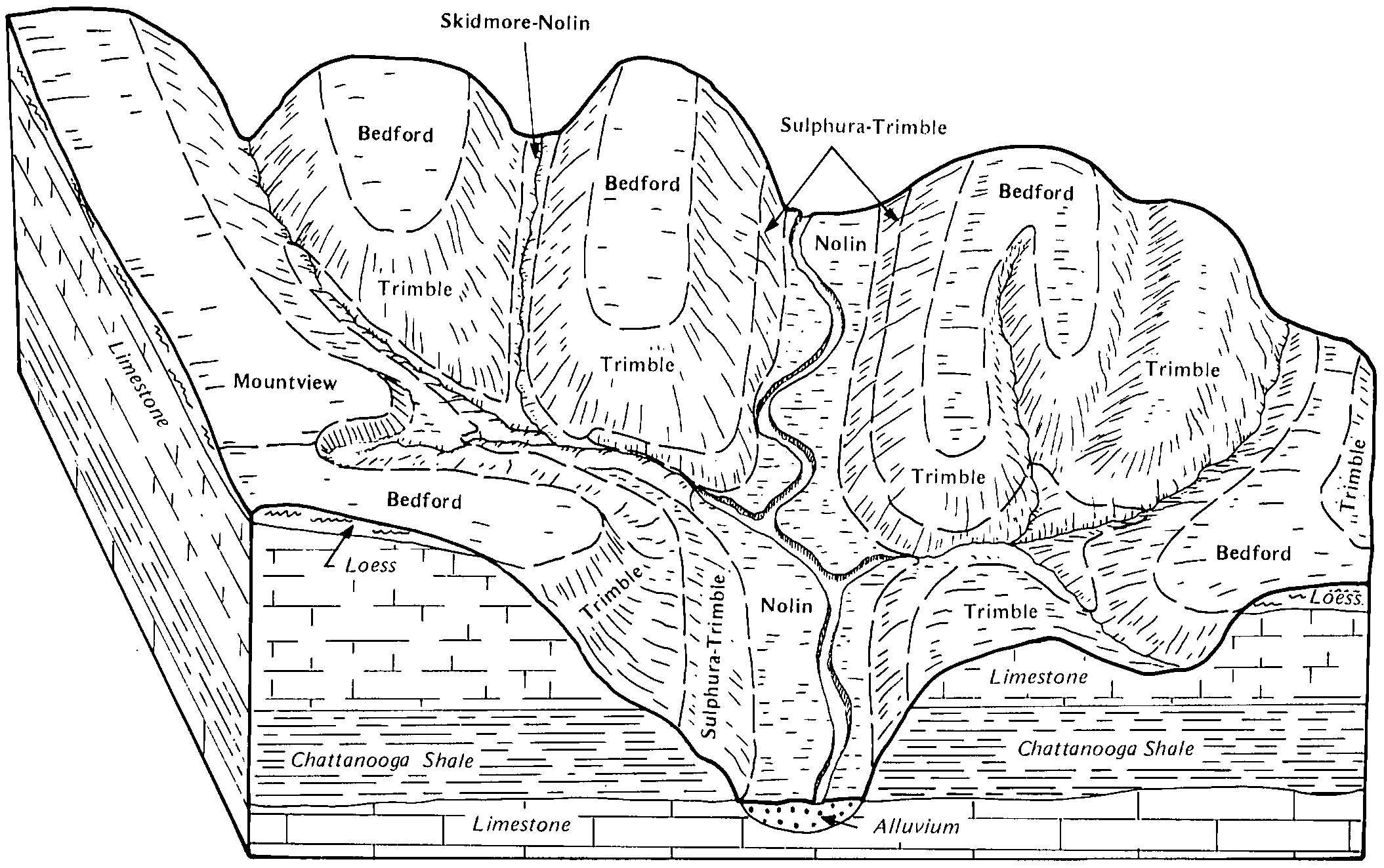
  11. KY-2012-01-26-08 | Allen County - September 1989

    Relationship of soils to topography and underlying material in the Trimblel-Bedford-Mountview general soil map unit (Soil Survey of Allen County, Kentucky; September 1989).

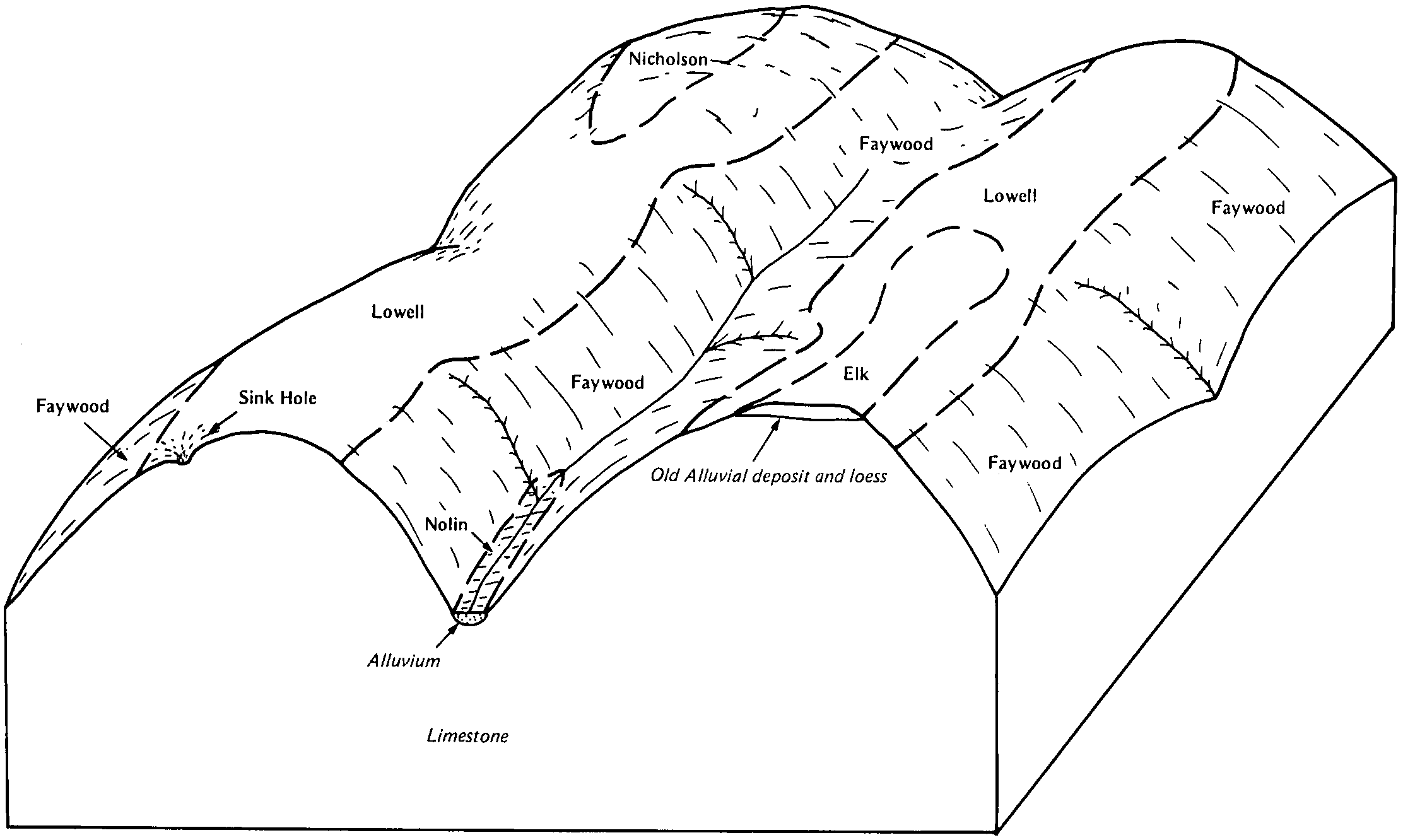
  12. KY-2012-01-26-10 | Anderson and Franklin Counties - May 1985

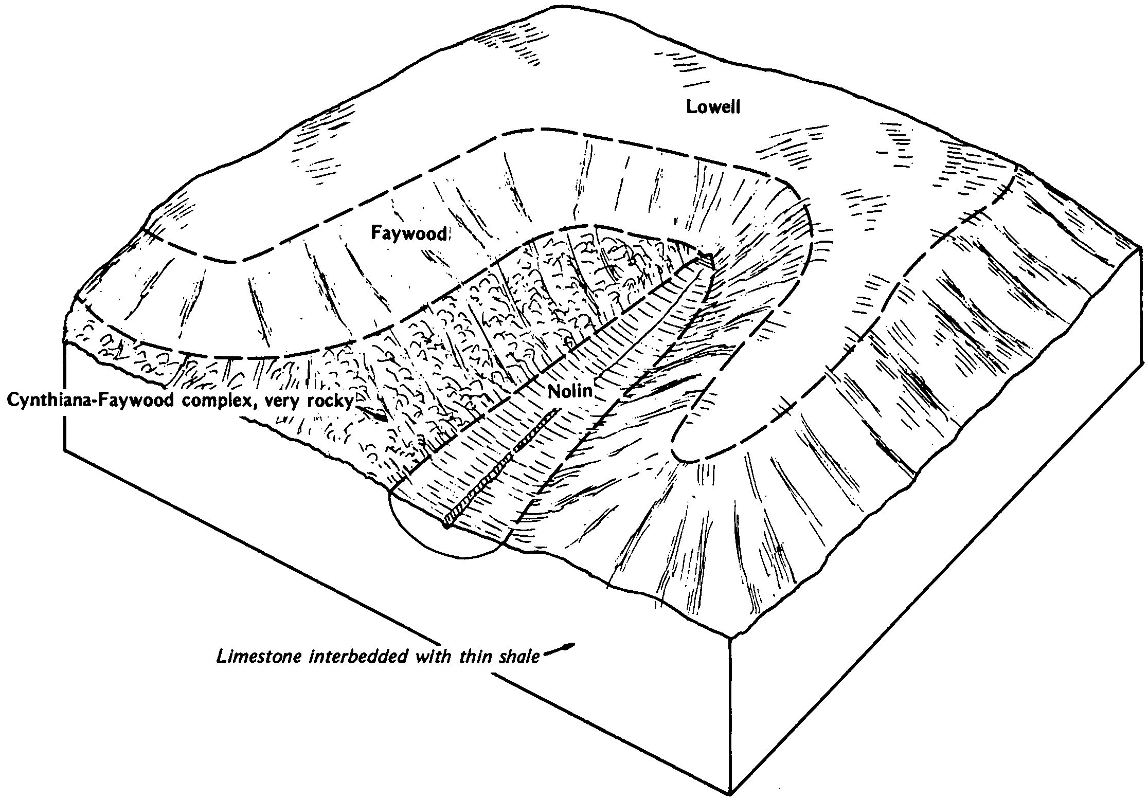
    Relationship of soils to topography and underlying material in the Faywood-Lowell unit (Soil Survey of Anderson and Franklin Counties, Kentucky; May 1985).

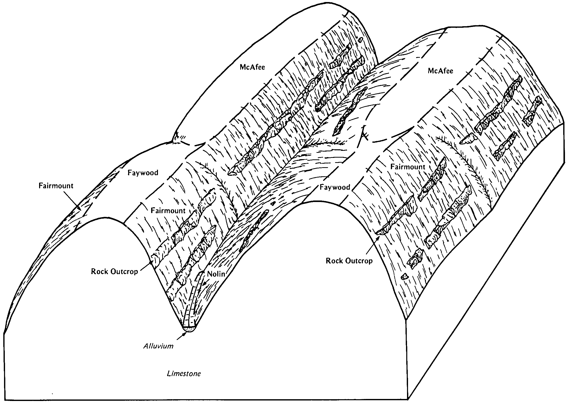
  13. KY-2012-01-26-11 | Anderson and Franklin Counties - May 1985

    Relationship of soils to topography and underlying material in the Fairmount-Rock outcrop-McAfee unit (Soil Survey of Anderson and Franklin Counties, Kentucky; May 1985).

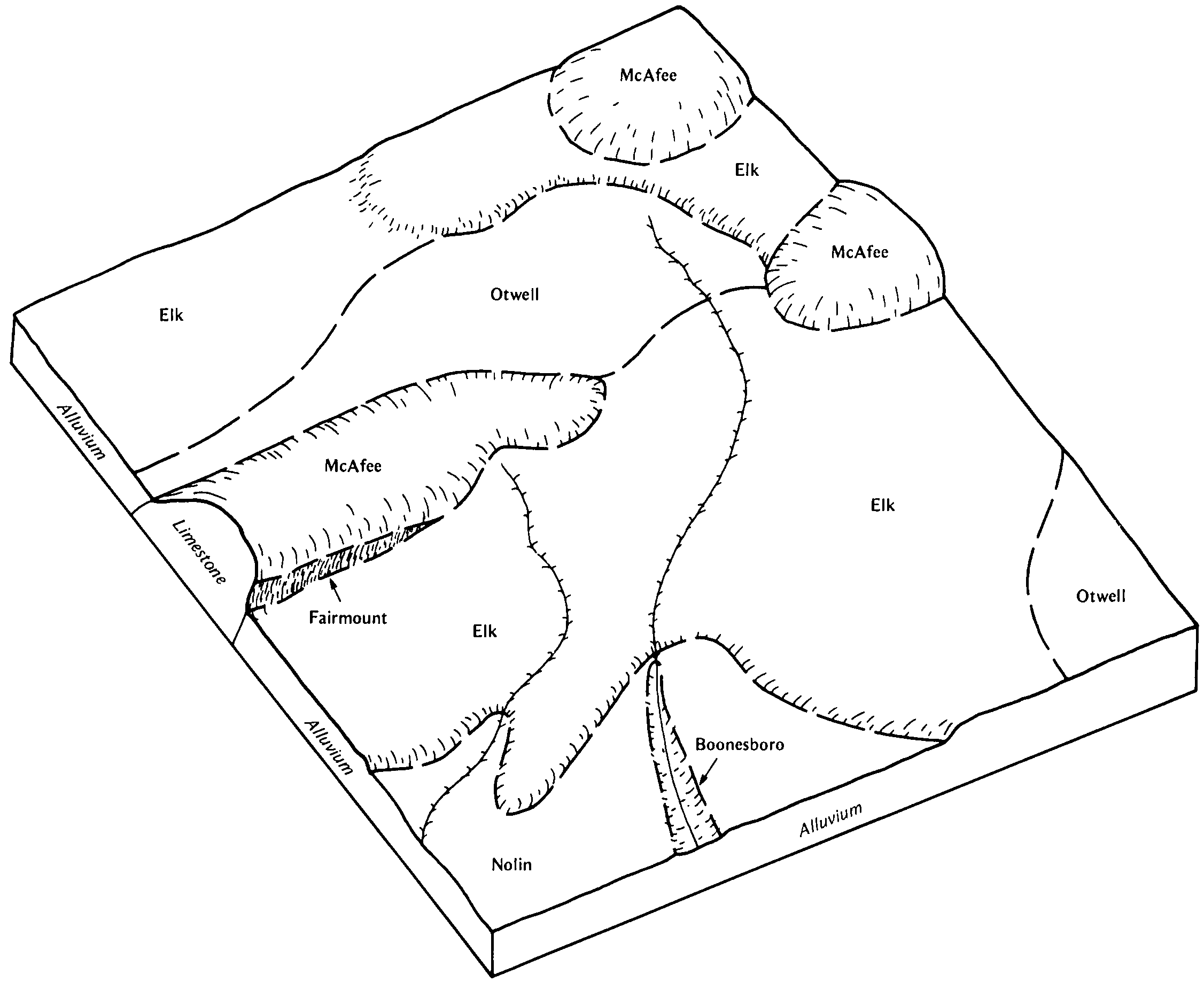
  14. KY-2012-01-26-12 | Anderson and Franklin Counties - May 1985

    Relationship of soils to topography and underlying material in the Elk-McAfee-Otwell unit (Soil Survey of Anderson and Franklin Counties, Kentucky; May 1985).

  15. KY-2012-01-26-14 | Anderson and Franklin Counties - May 1985

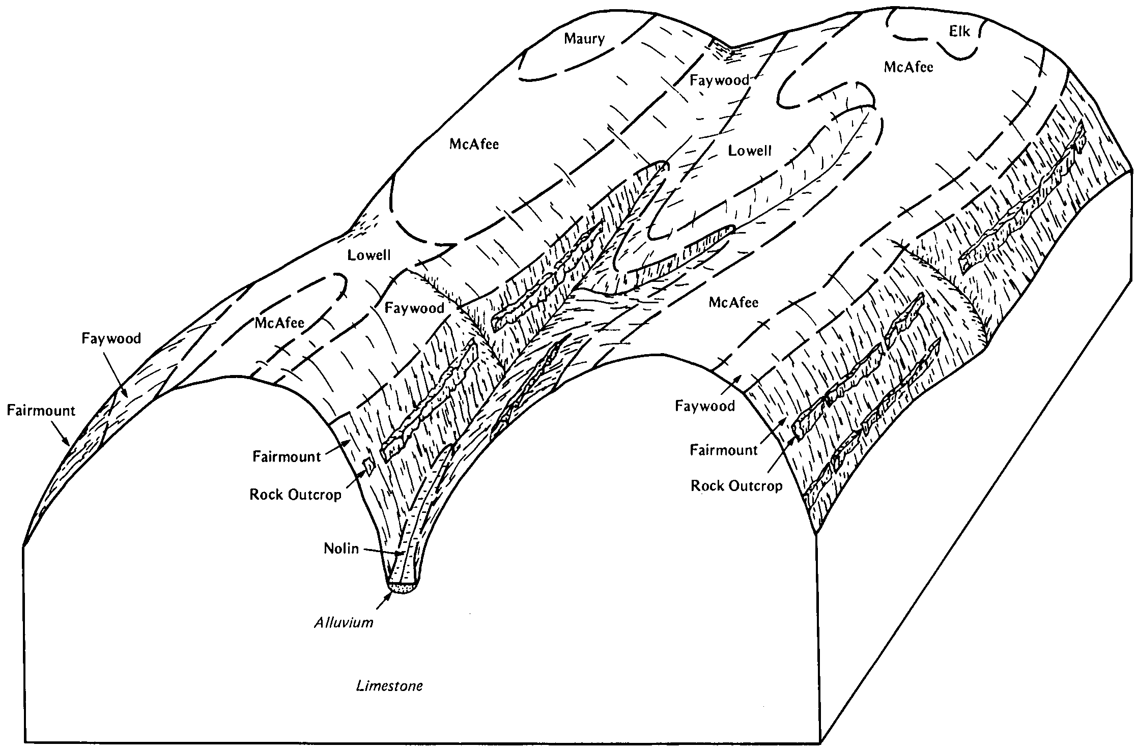
    Relationship of soils to topography and underlying material in the McAfee-Faywood-Fairmount unit (Soil Survey of Anderson and Franklin Counties, Kentucky; May 1985).

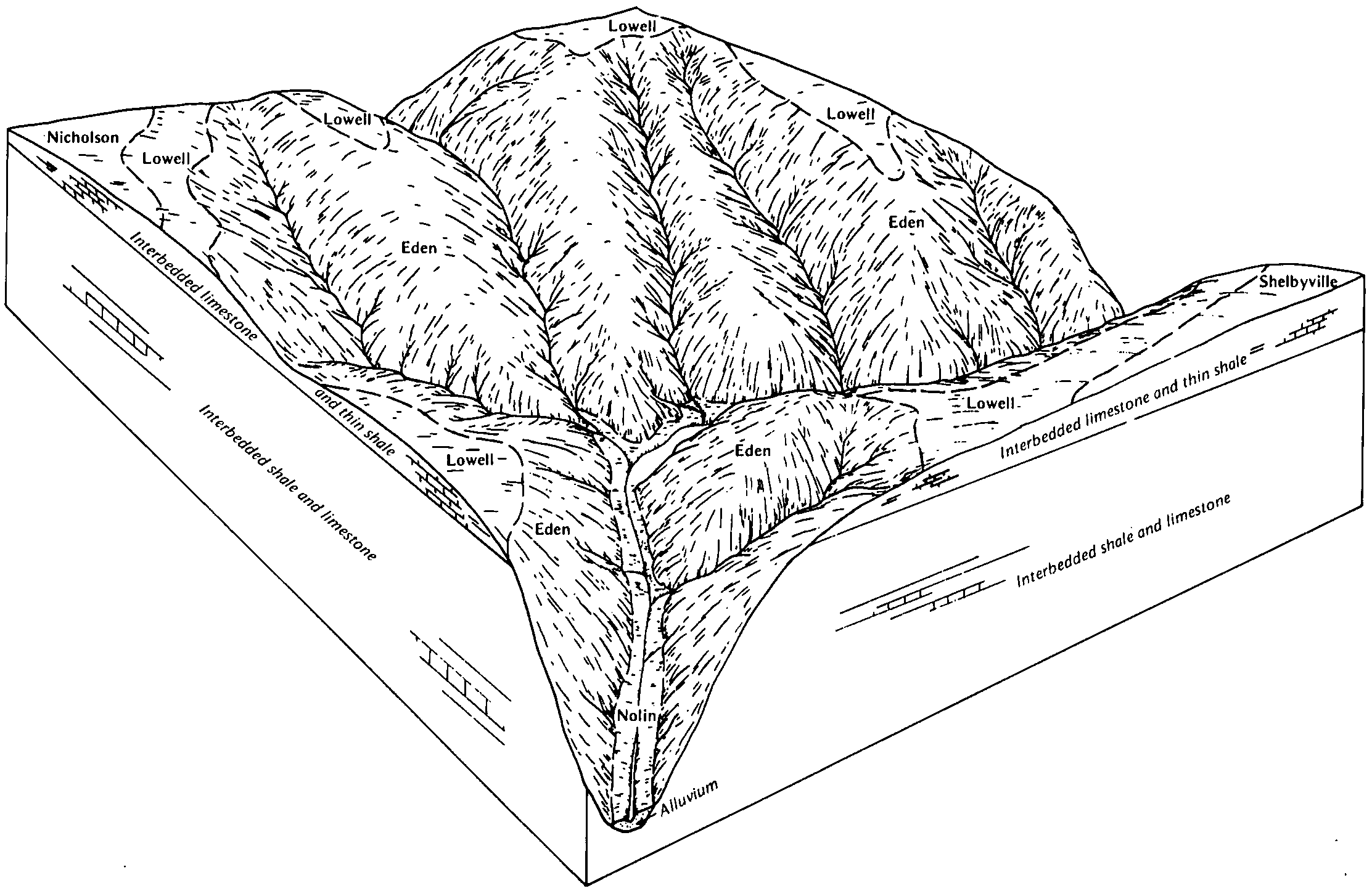
  16. KY-2012-01-26-28 | Bourbon and Nicholas Counties - October 1982

    Typical pattern of soils and parent material in the Lowell-Faywood-Cynthiana map unit (Soil Survey of Bourbon and Nicholas Counties, Kentucky; October 1982).

  17. KY-2012-01-26-30 | Boyle and Mercer Counties - April 1983

    Typical pattern of soils and underlying material in the Lowell-Faywood-Eden map unit (Soil Survey of Boyle and Mercer Counties, Kentucky; April 1983).

  18. KY-2012-01-26-31 | Boyle and Mercer Counties - April 1983

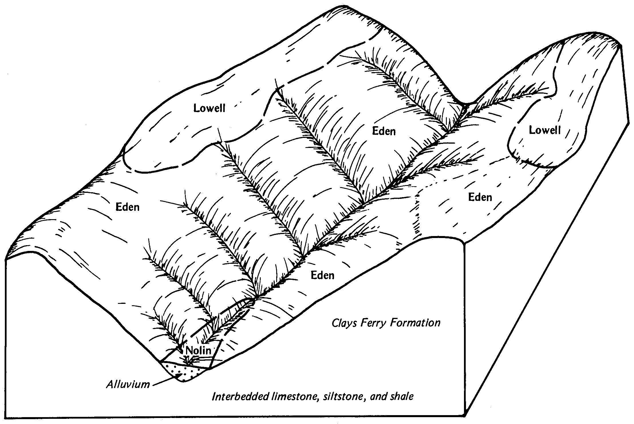
    Typical pattern of soils and underlying material in the Eden-Lowell map unit (Soil Survey of Boyle and Mercer Counties, Kentucky; April 1983).

  19. KY-2012-01-26-32 | Boyle and Mercer Counties - April 1983

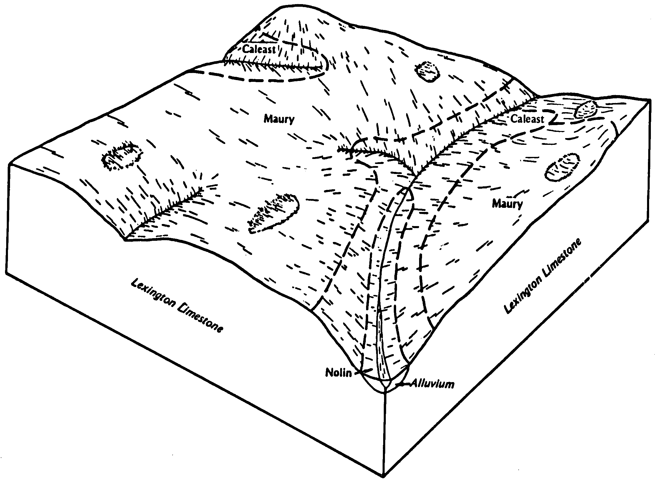
    Typical pattern of soils and underlying material in the Maury-Caleast map unit (Soil Survey of Boyle and Mercer Counties, Kentucky; April 1983).

  20. KY-2012-01-26-33 | Boyle and Mercer Counties - April 1983

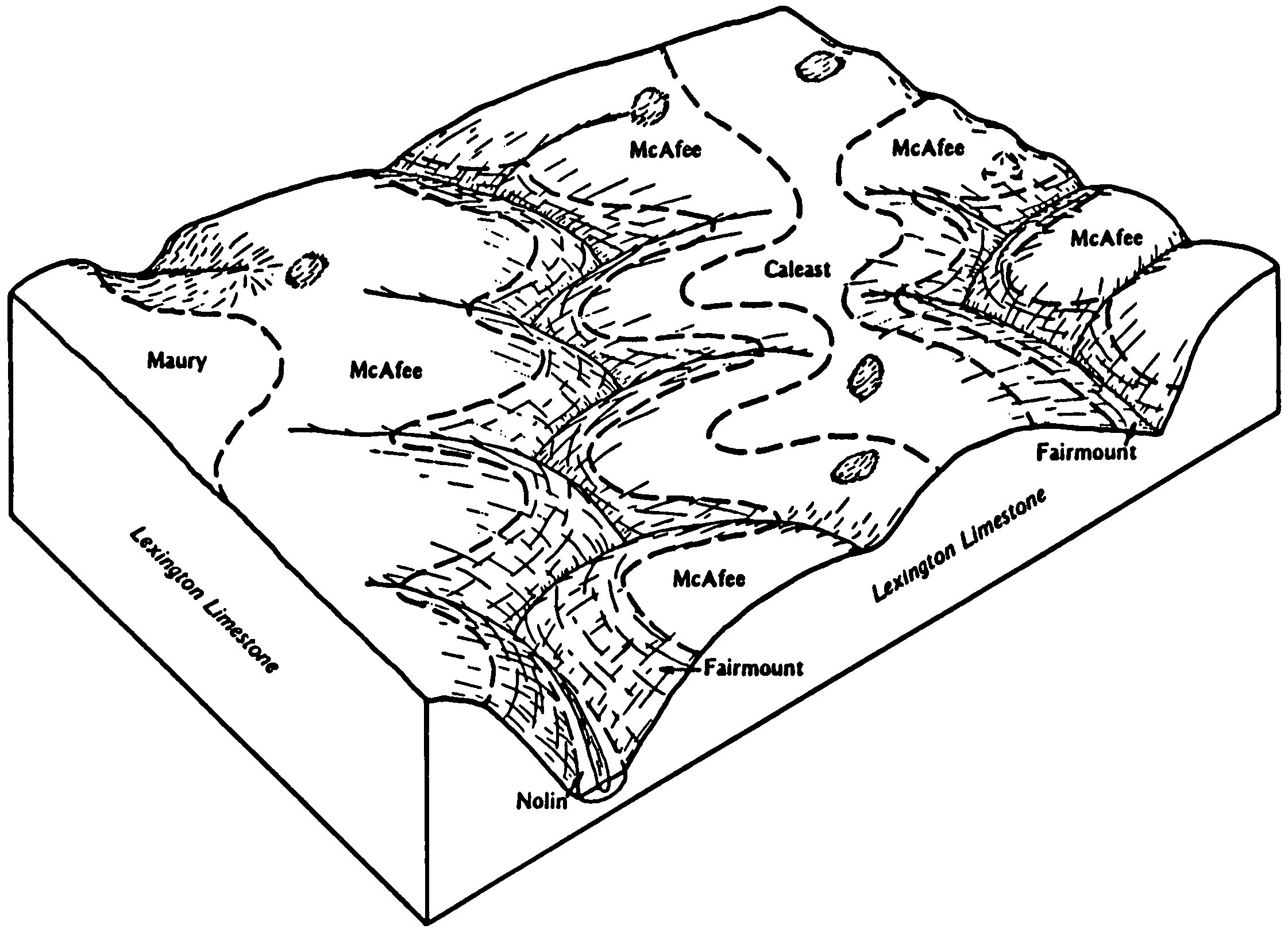
    Typical pattern of soils and underlying material in the McAfee-Caleast-Fairmount map unit (Soil Survey of Boyle and Mercer Counties, Kentucky; April 1983).

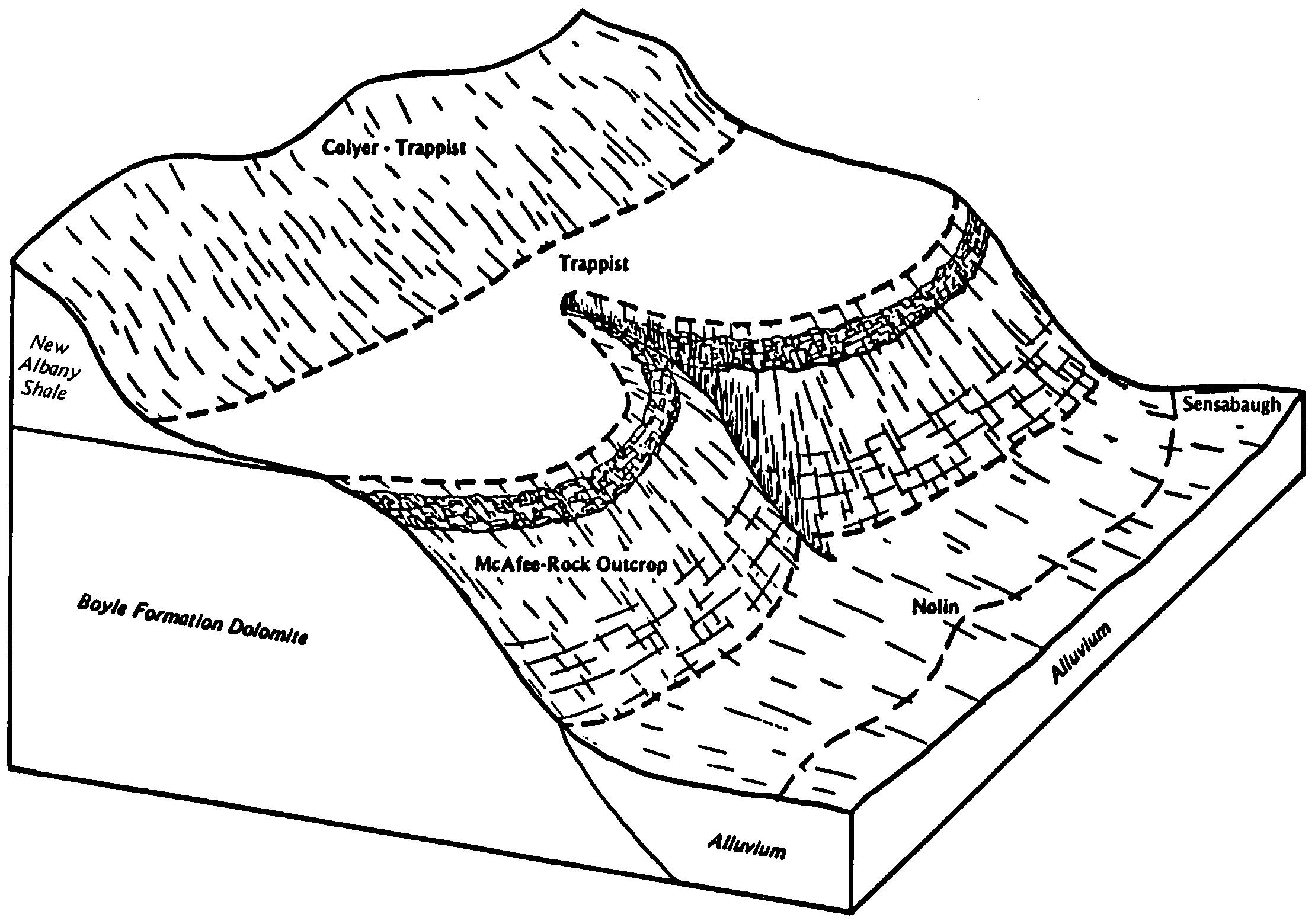
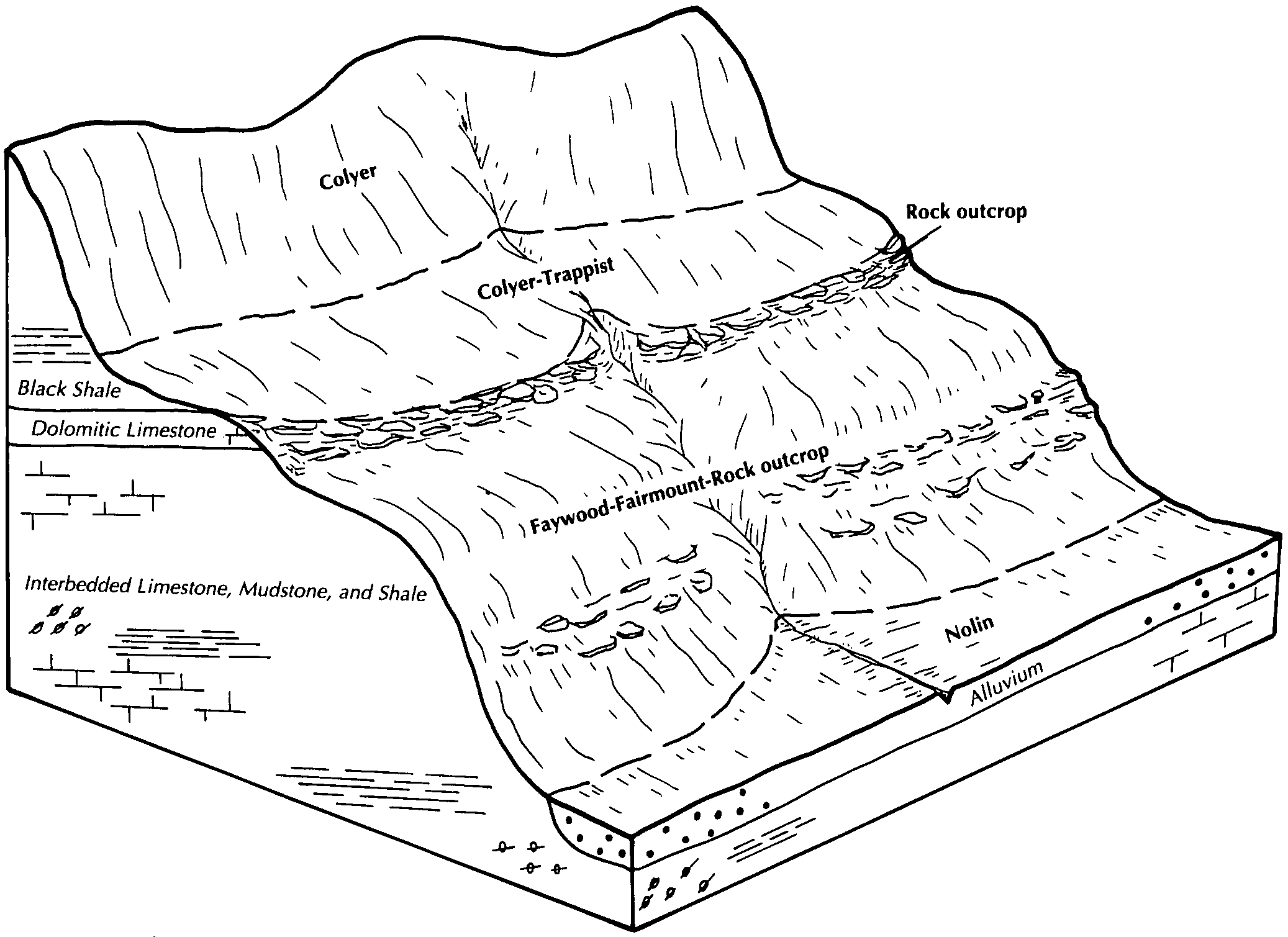
  21. KY-2012-01-26-37 | Boyle and Mercer Counties - April 1983

    Typical pattern of soils and underlying material in the Trappist-McAfee-Colyer map unit (Soil Survey of Boyle and Mercer Counties, Kentucky; April 1983).

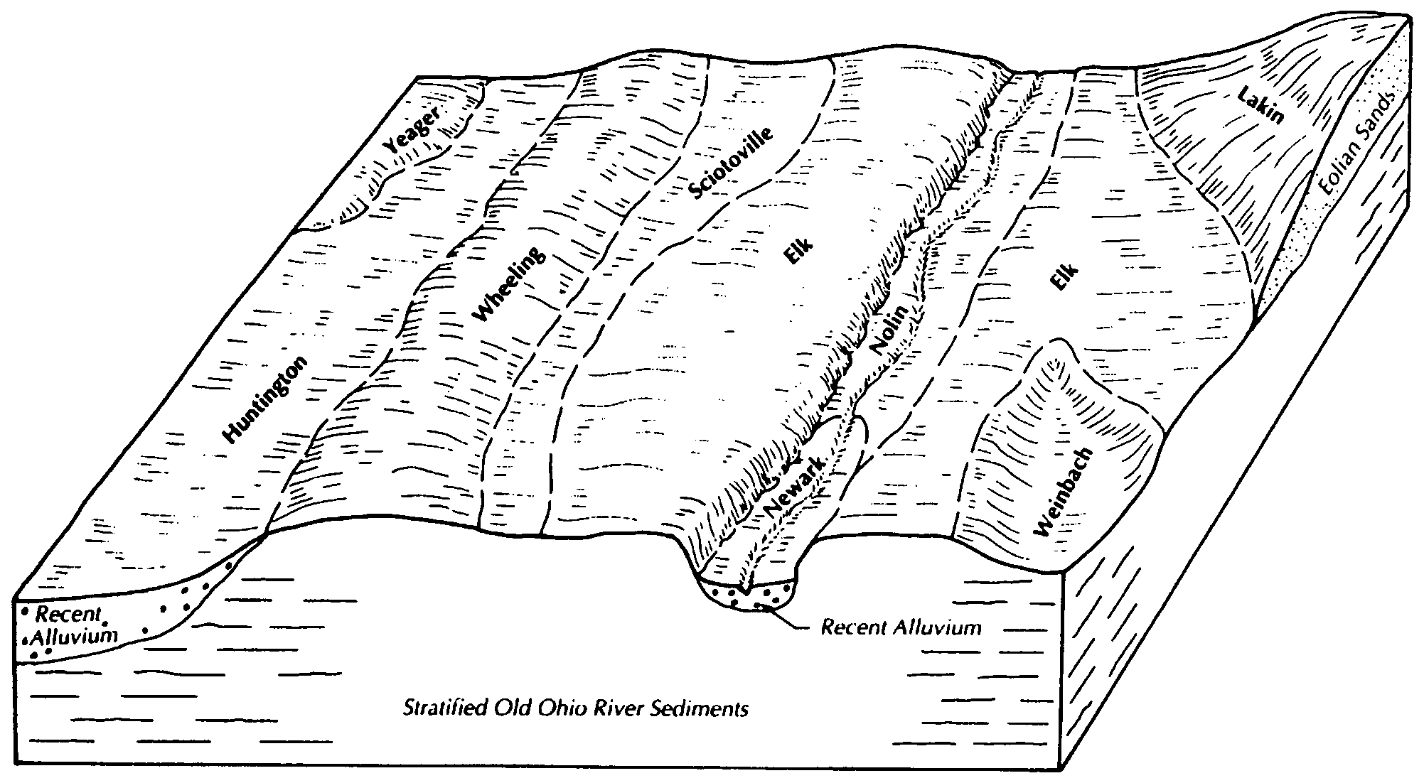
  22. KY-2012-01-26-38 | Breckinridge and Meade Counties - 2001

    Typical relationship of soils to topography and the underlying material in the Elk-Huntington-Wheeling general soil map unit (Soil Survey of Breckinridge and Meade Counties, Kentucky; 2001).

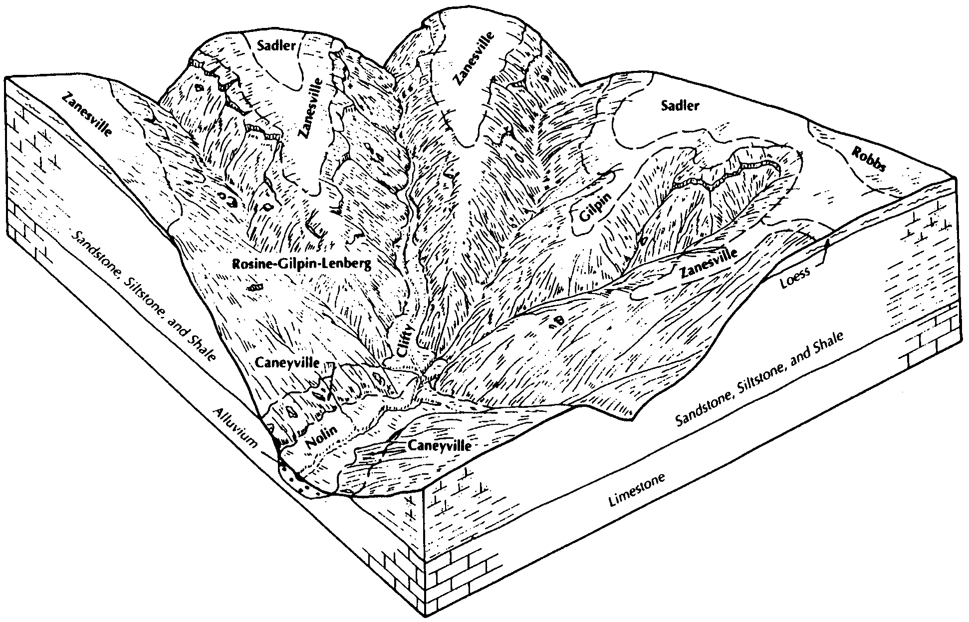
  23. KY-2012-01-26-40 | Breckinridge and Meade Counties - 2001

    Typical relationship of soils to topography and the underlying material in the Rosine-Gilpin-Zanesville general soil map unit (Soil Survey of Breckinridge and Meade Counties, Kentucky; 2001).

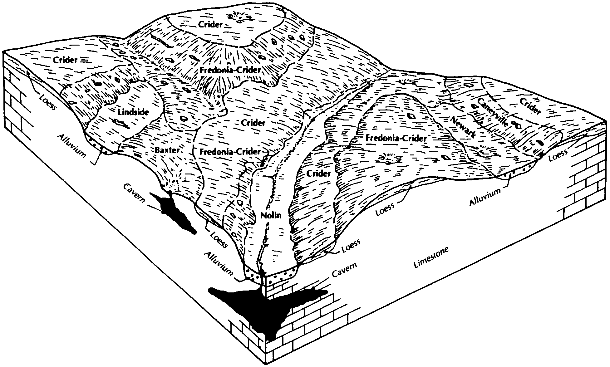
  24. KY-2012-01-26-41 | Breckinridge and Meade Counties - 2001

    Typical relationship of soils to topography and the underlying material in the Crider-Fredonia general soil map unit (Soil Survey of Breckinridge and Meade Counties, Kentucky; 2001).

  25. KY-2012-01-27-02 | Bullitt and Spencer Counties - September 1986

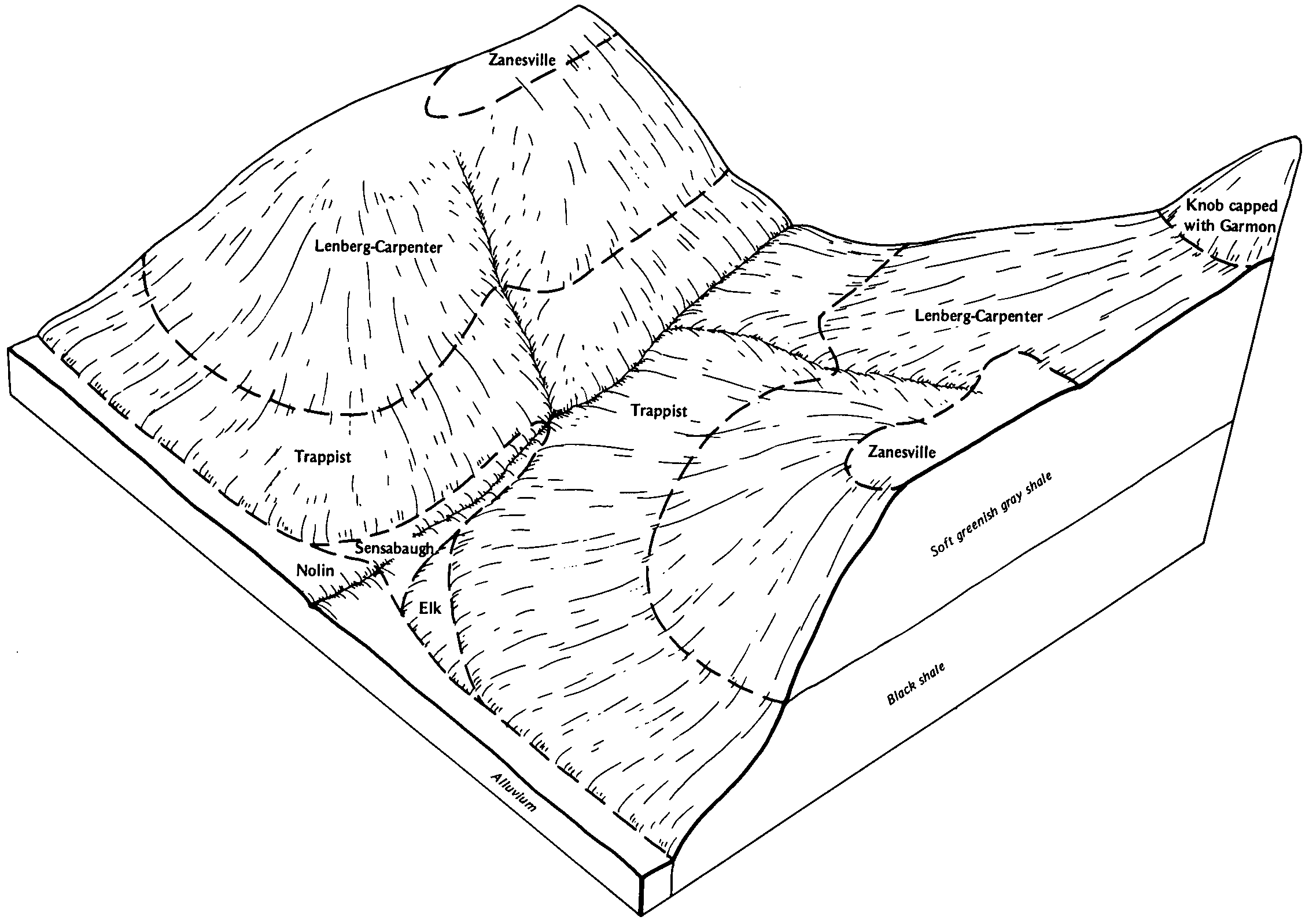
    The relationship of soils to topography and underlying material in the Trappist-Lenberg-Carpenter general soil map unit (Soil Survey of Bullitt and Spencer Counties, Kentucky; September 1986).

  26. KY-2012-01-27-03 | Bullitt and Spencer Counties - September 1986

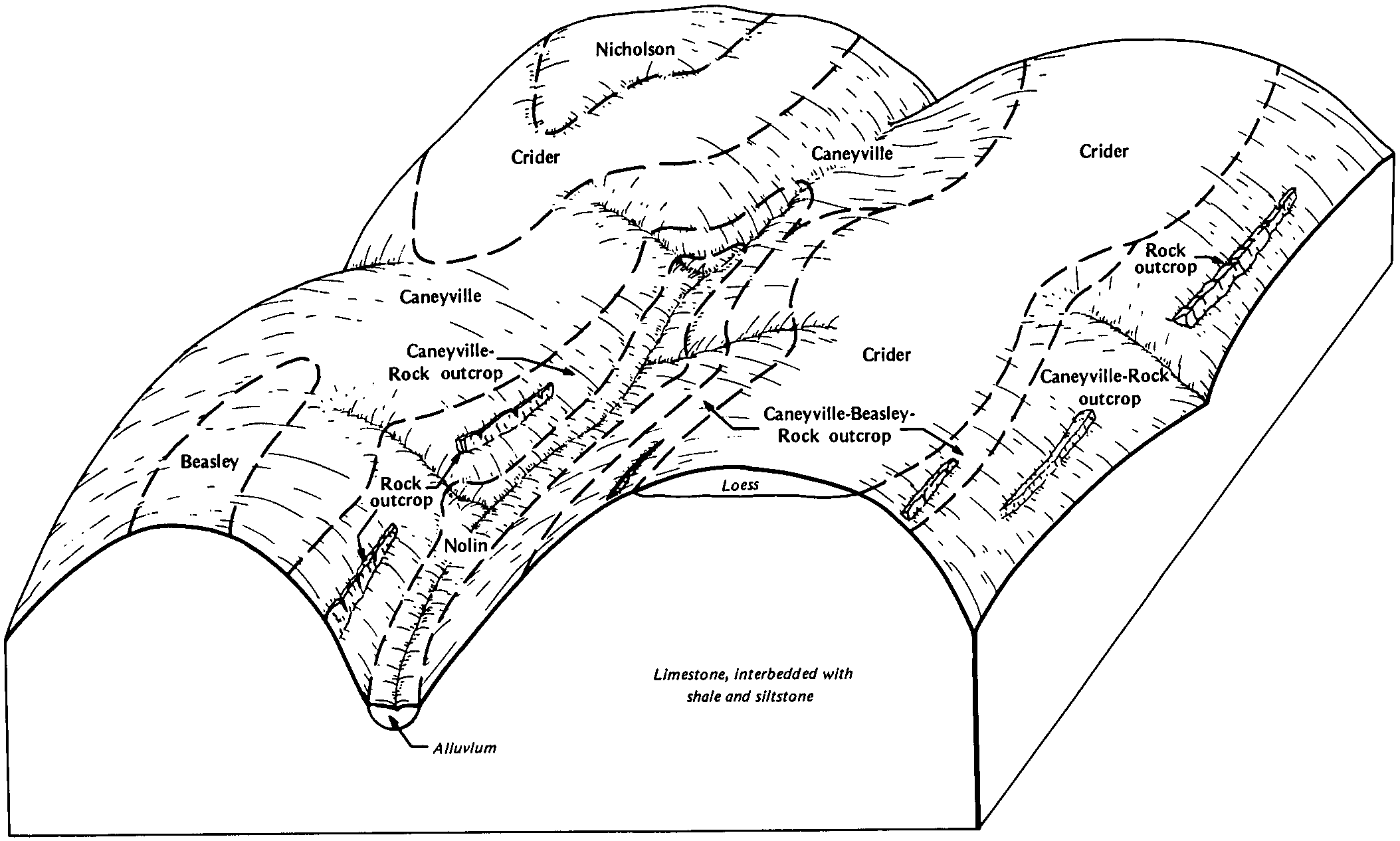
    The relationship of soils to topography and underlying material in the Caneyville-Crider general soil map unit (Soil Survey of Bullitt and Spencer Counties, Kentucky; September 1986).

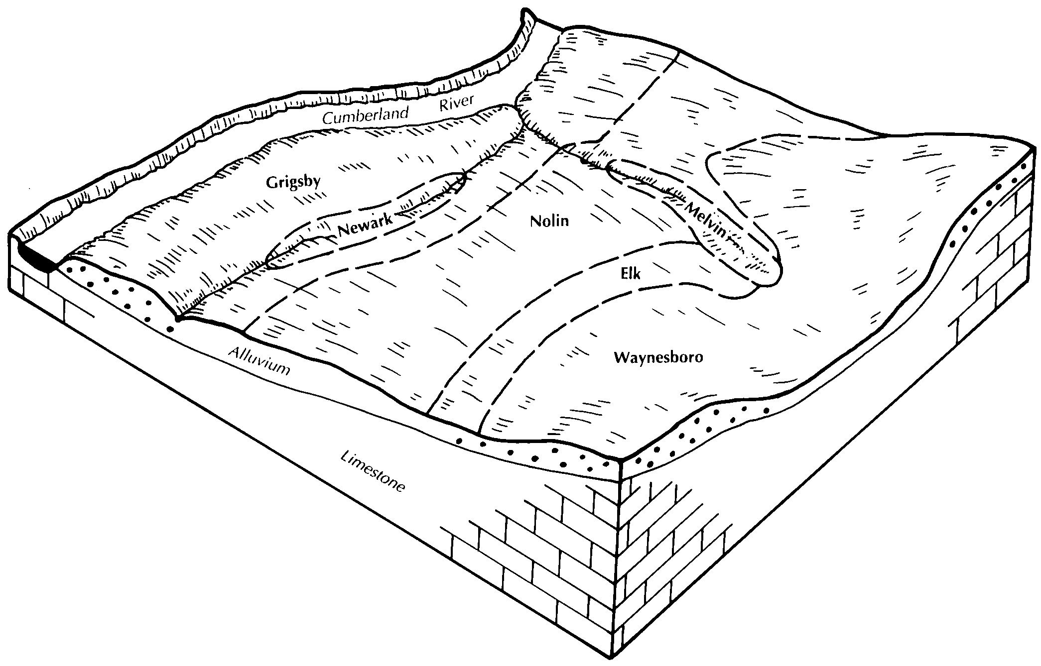
  27. KY-2012-01-27-05 | Bullitt and Spencer Counties - September 1986

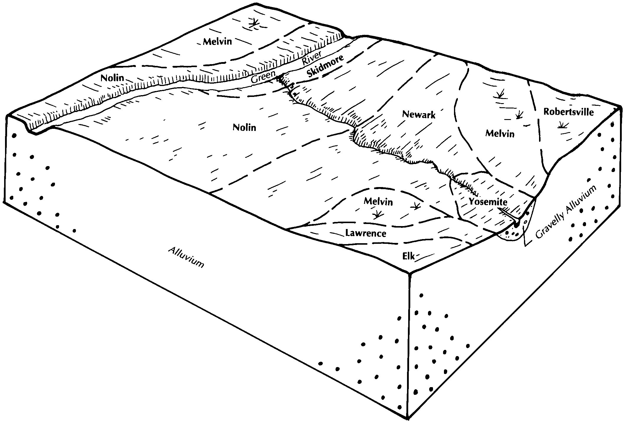
    The relationship of soils to topography and underlying material in the Nolin-Elk-Newark general soil map unit (Soil Survey of Bullitt and Spencer Counties, Kentucky; September 1986).

  28. KY-2012-01-27-06 | Bullitt and Spencer Counties - September 1986

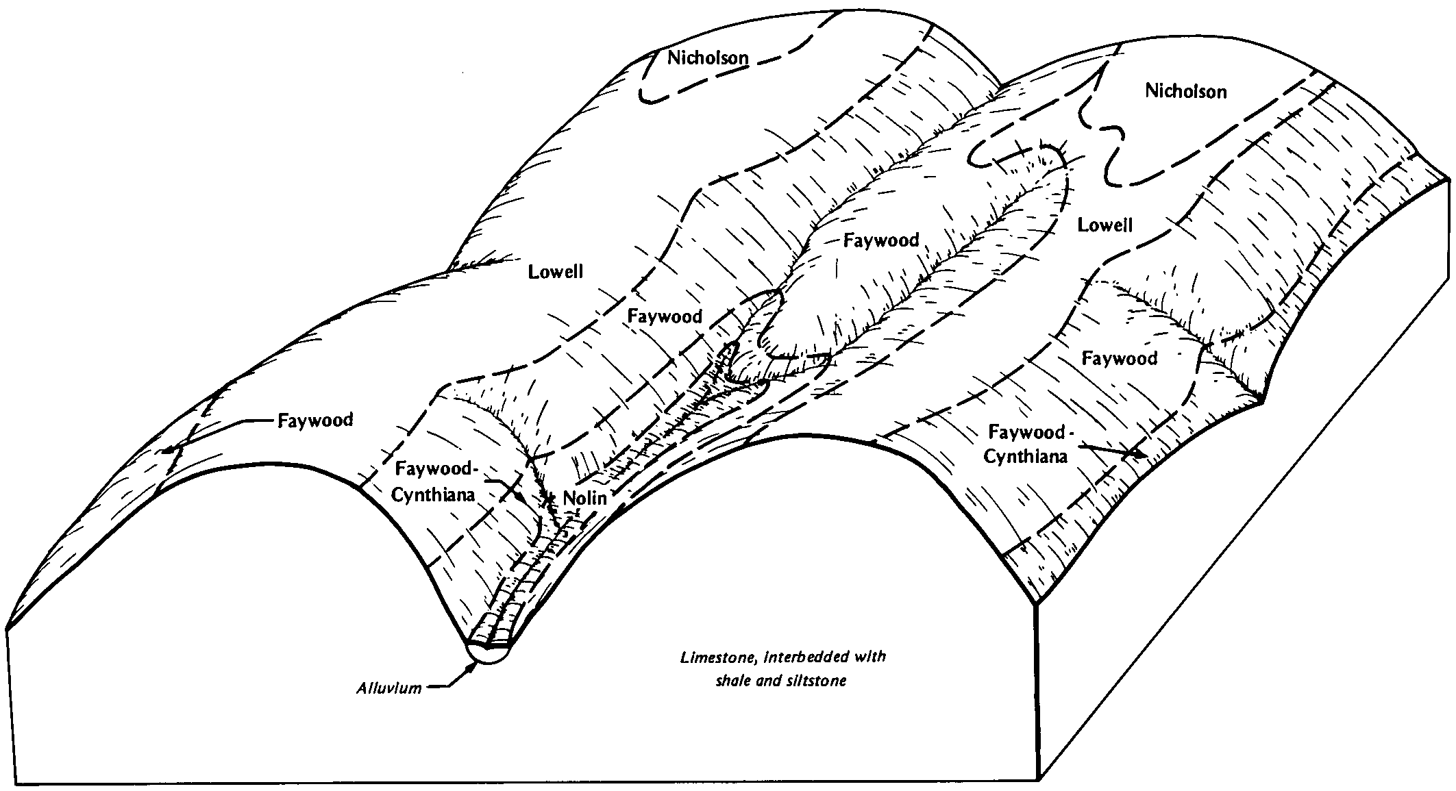
    The relationship of soils to topography and underlying material in the Faywood-Lowell general soil map unit (Soil Survey of Bullitt and Spencer Counties, Kentucky; September 1986).

  29. KY-2012-01-27-27 | Casey County - August 1994

    Typical pattern of soils and underlying materials in the Nolin-Melvin-Newark general soil map unit (Soil Survey of Casey County, Kentucky; August 1994).

  30. KY-2012-01-27-29 | Casey County - August 1994

    Typical pattern of soils and underlying materials in the Colyer-Faywood-Nolin general soil map unit (Soil Survey of Casey County, Kentucky; August 1994).

  31. KY-2012-01-27-46 | Clinton County - May 1994

    Pattern of soils and parent material in the Waynesboro-Nolin-Grigsby general soil map unit (Soil Survey of Clinton County, Kentucky; May 1994).

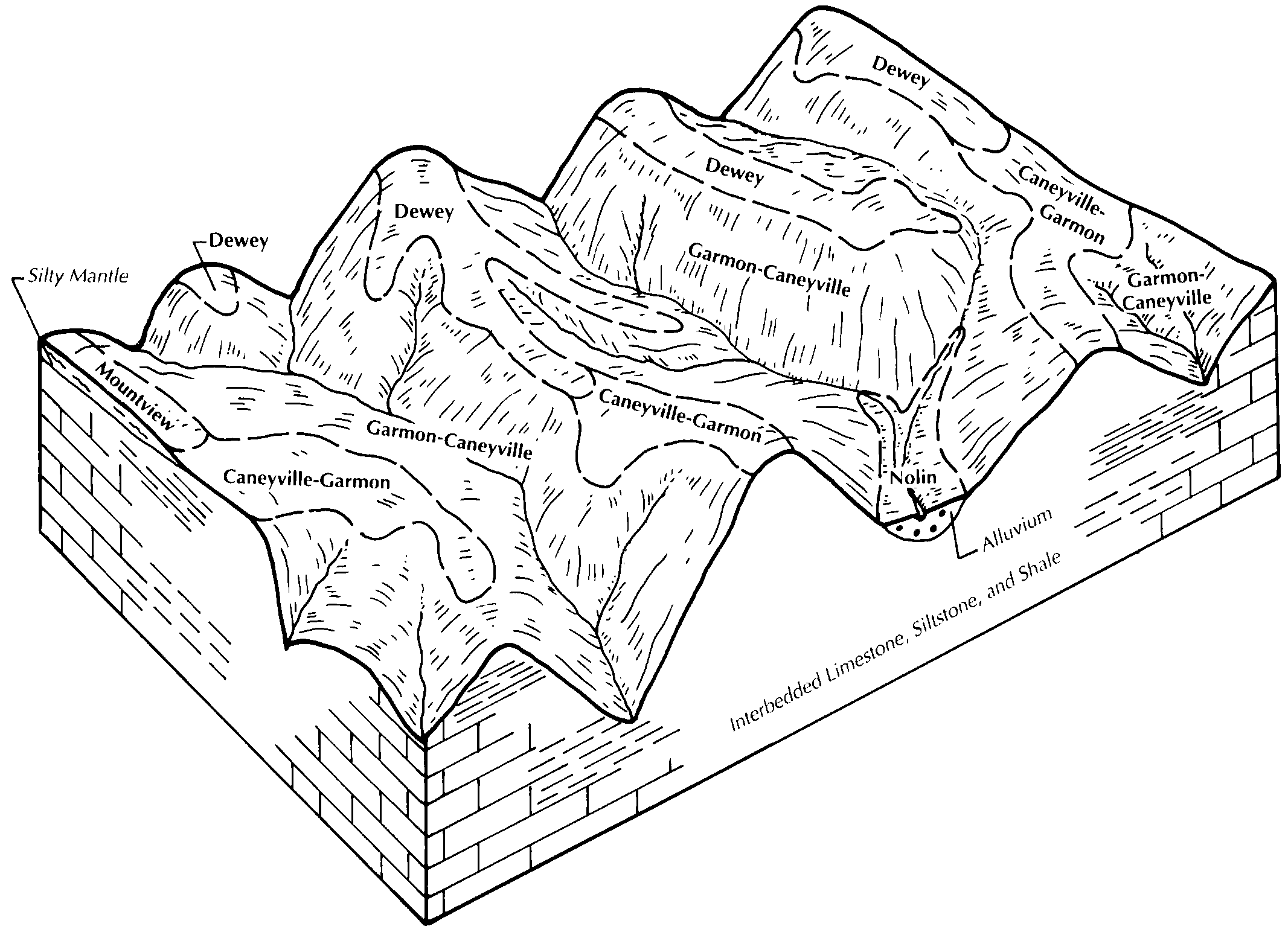
  32. KY-2012-01-27-47 | Clinton County - May 1994

    Pattern of soils and parent material in the Garmon-Caneyville-Dewey general soil map unit (Soil Survey of Clinton County, Kentucky; May 1994).

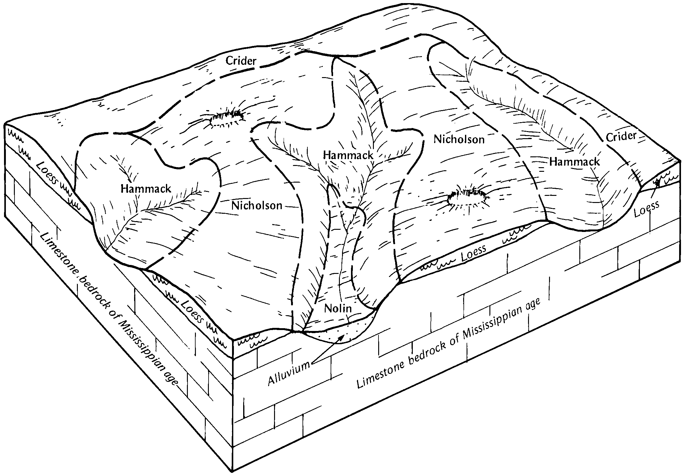
  33. KY-2012-01-27-50 | Crittenden County - September 1988

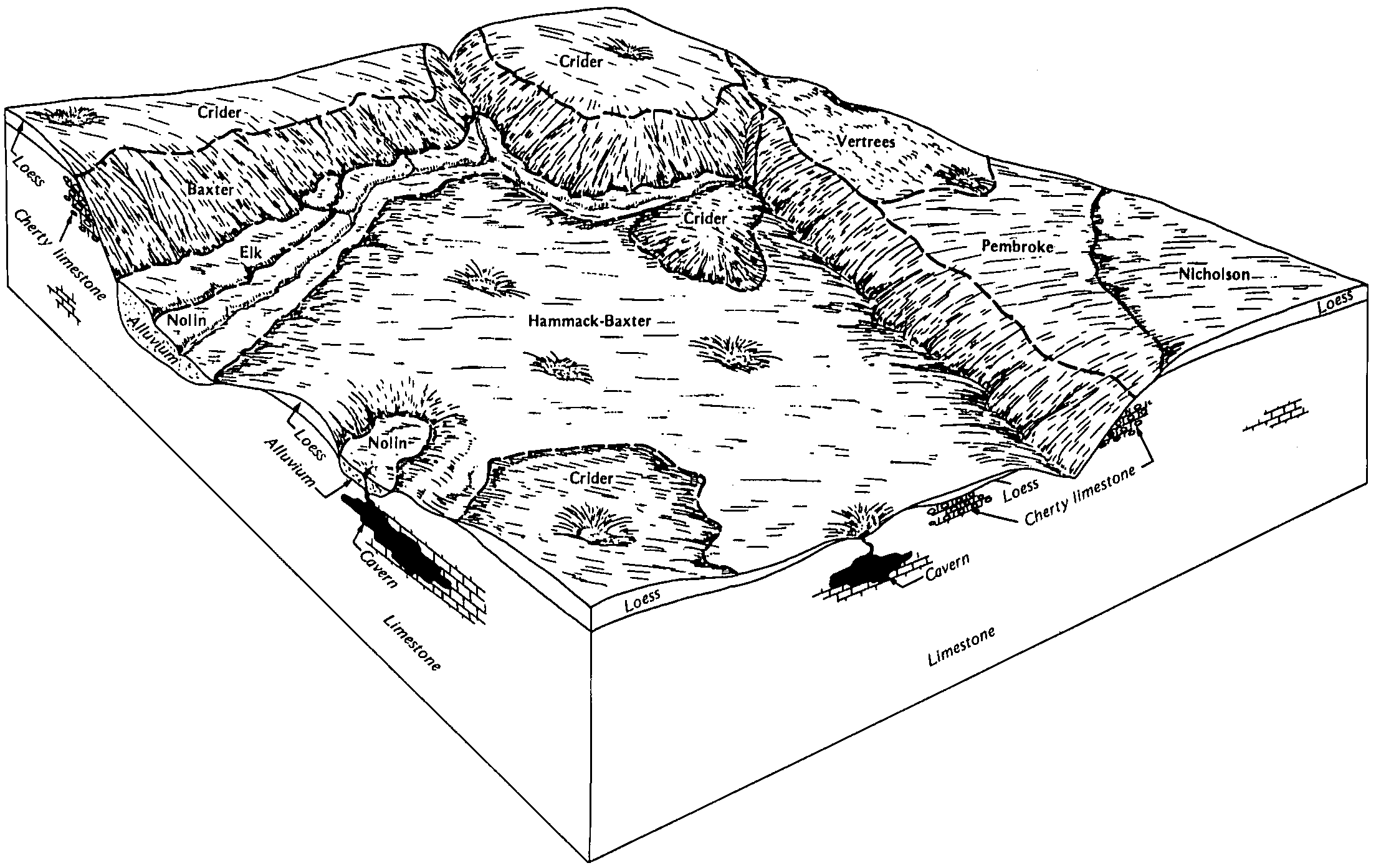
    Relationship of soils to topography and underlying material in the Nicholson-Hammack-Crider map unit (Soil Survey of Crittenden County, Kentucky; September 1988).

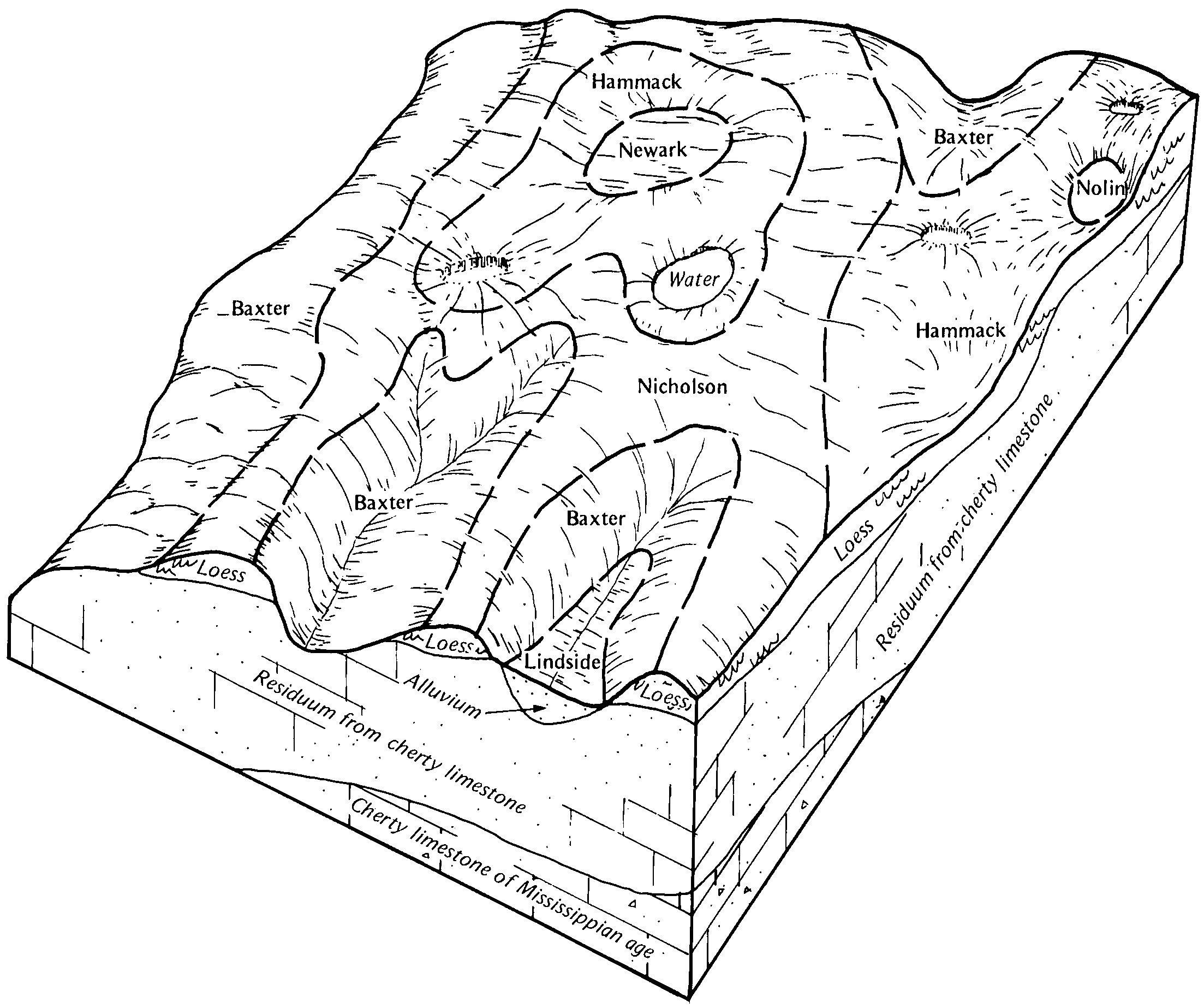
  34. KY-2012-01-27-51 | Crittenden County - September 1988

    Relationship of soils to topography and underlying material in the Baxter-Hammack-Nicholson map unit (Soil Survey of Crittenden County, Kentucky; September 1988).

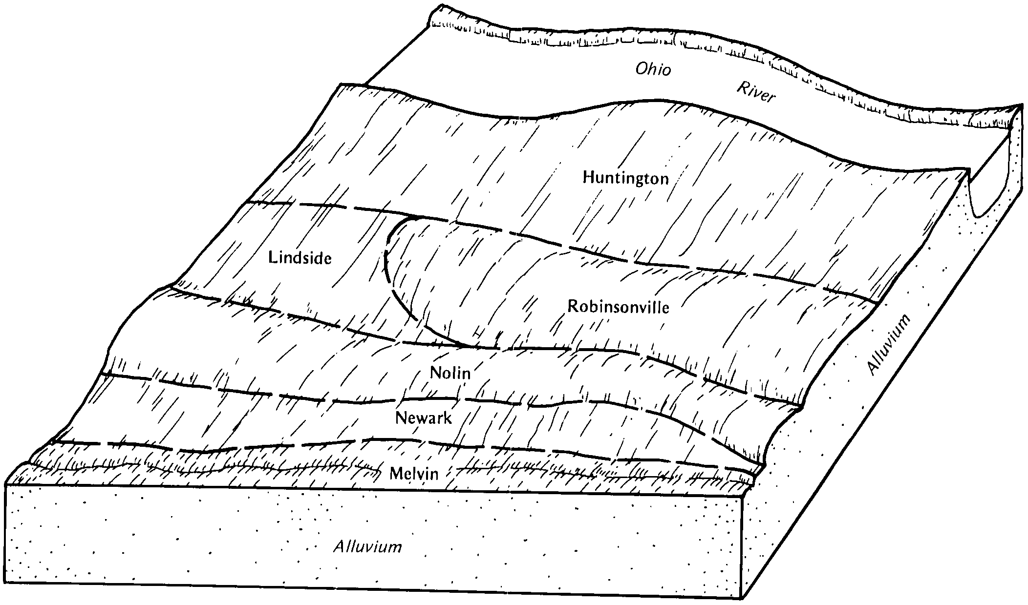
  35. KY-2012-01-27-55 | Crittenden County - September 1988

    Relationship of soils to topography and underlying material in the Huntington-Robinsonville-Nolin map unit (Soil Survey of Crittenden County, Kentucky; September 1988).

  36. KY-2012-01-27-72 | Fleming County - October 1993

    Typical pattern of soils and parent material in the Lowell-Faywood-Cynthiana soil map unit (Soil Survey of Fleming County, Kentucky; October 1993).

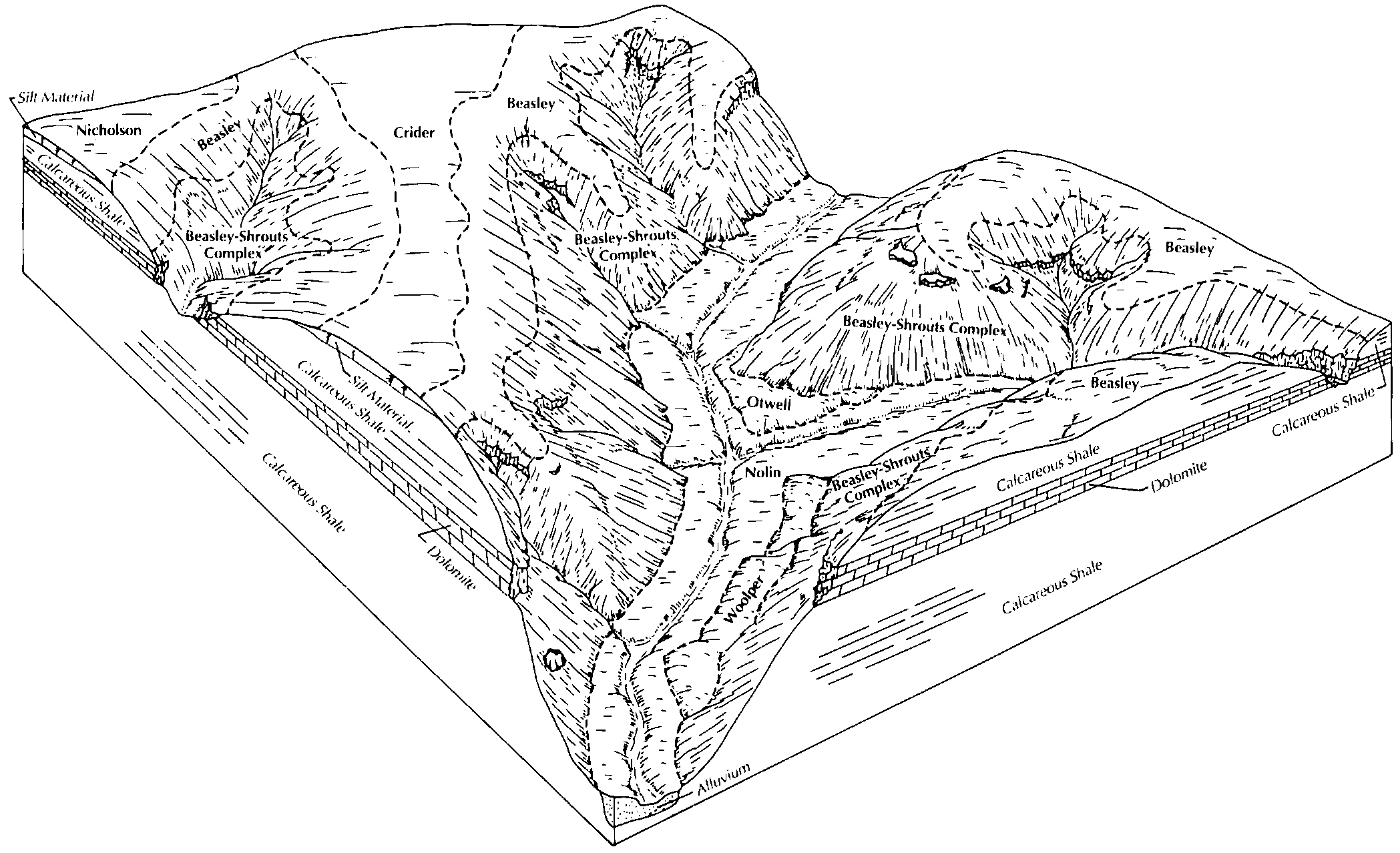
  37. KY-2012-01-27-73 | Fleming County - October 1993

    Typical pattern of soils and parent material in the Beasley-Shrouts-Crider soil map unit (Soil Survey of Fleming County, Kentucky; October 1993).

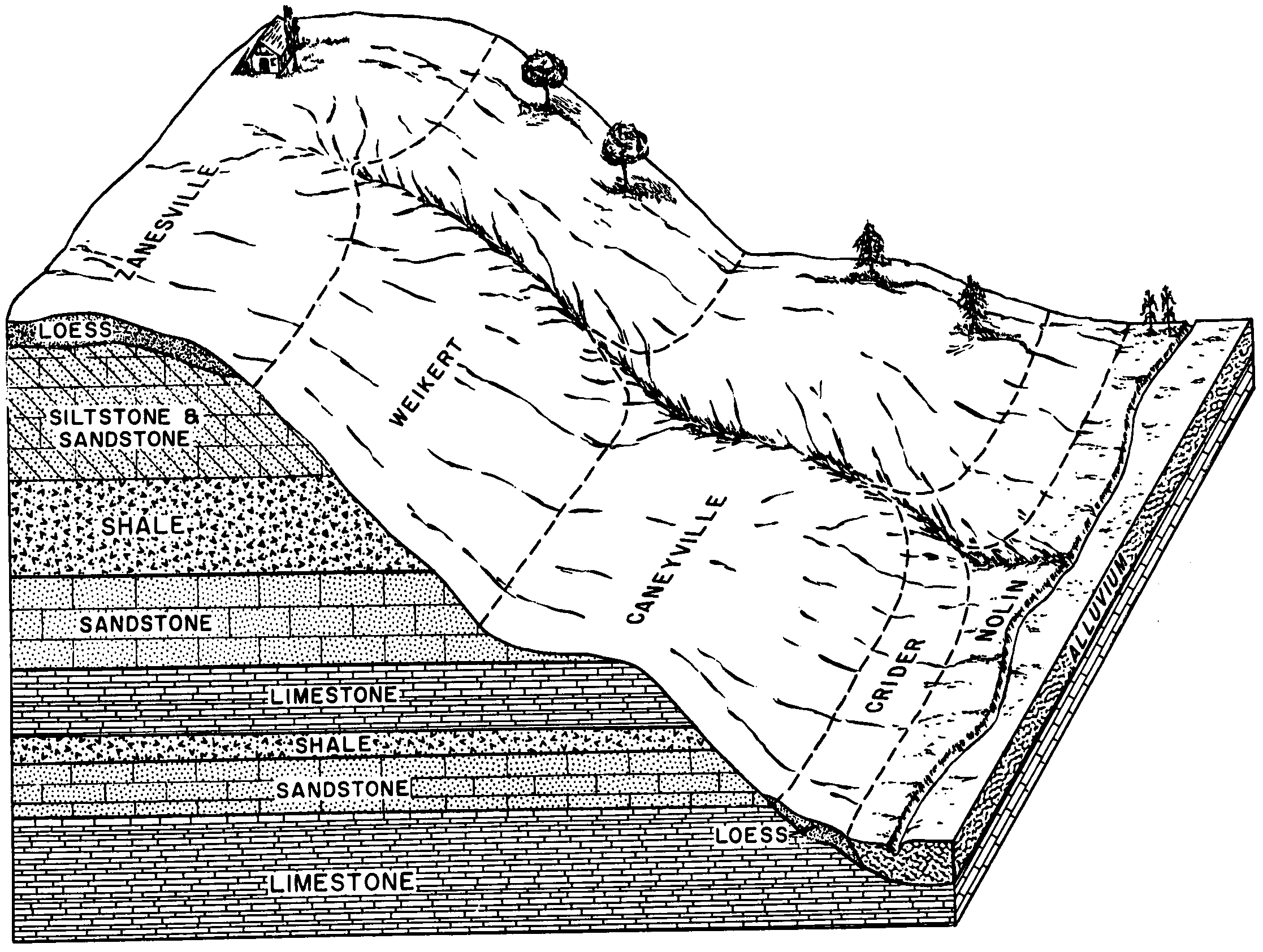
  38. KY-2012-01-30-05 | Grayson County - December 1972

    Relationship of soils to topography and underlying material in the Caneyville-Weikert-Zanesville association (Soil Survey of Grayson County, Kentucky; December 1972).

  39. KY-2012-01-30-07 | Green and Taylor Counties - July 1982

    Pattern of soils and underlying material in the Frederick-Nolichucky-Riney general soil map unit (Soil Survey of Green and Taylor Counties, Kentucky; July 1982).

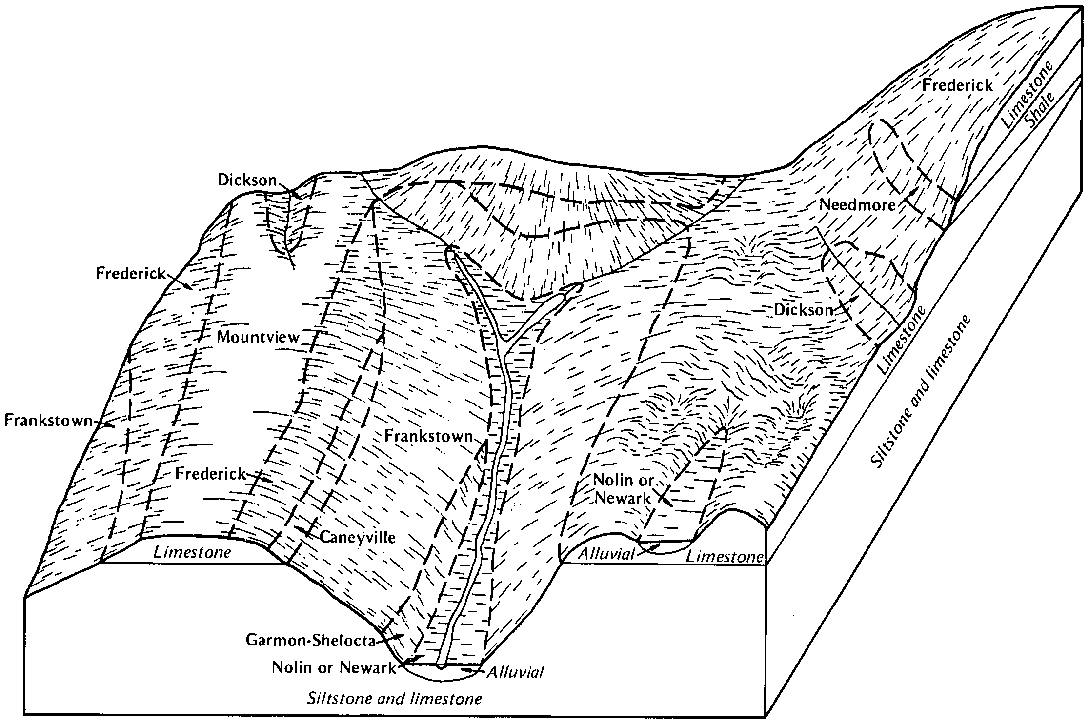
  40. KY-2012-01-30-08 | Green and Taylor Counties - July 1982

    Pattern of soils and underlying material in the Frederick-Frankstown-Mountview general soil map unit (Soil Survey of Green and Taylor Counties, Kentucky; July 1982).

  41. KY-2012-01-30-09 | Green and Taylor Counties - July 1982

    Pattern of soils and underlying material in the Frederick-Mountview-Frankstown general soil map unit (Soil Survey of Green and Taylor Counties, Kentucky; July 1982).

  42. KY-2012-01-30-10 | Green and Taylor Counties - July 1982

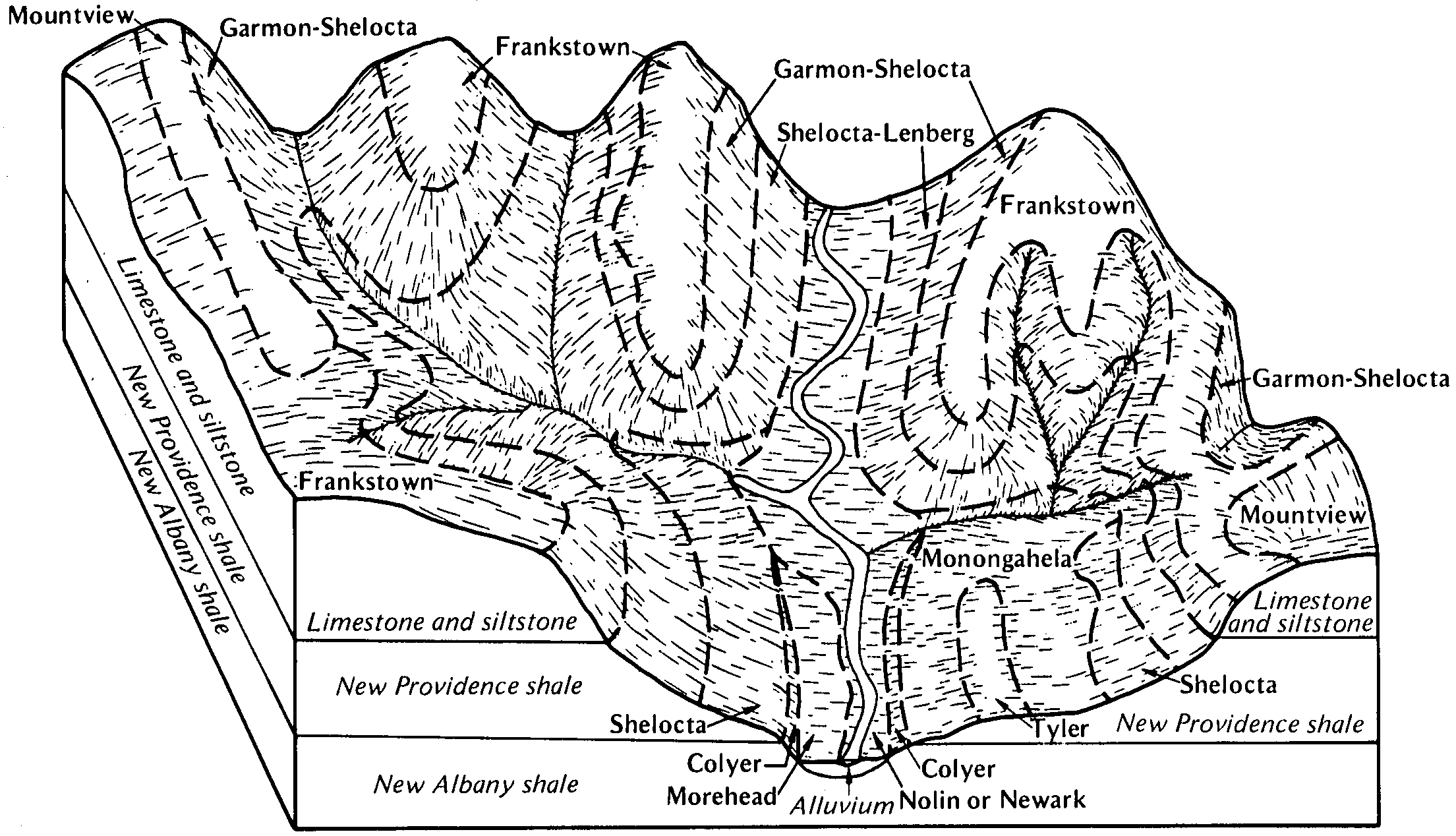
    Pattern of soils and underlying material in the Garmon-Shelocta-Frankstown general soil map unit (Soil Survey of Green and Taylor Counties, Kentucky; July 1982).

  43. KY-2012-01-30-15 | Hart County - May 1993

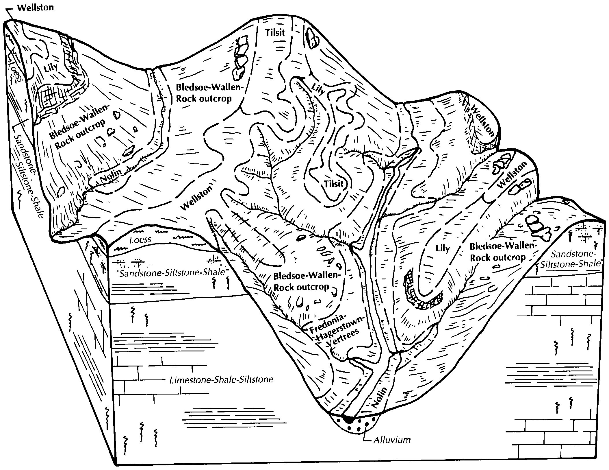
    Typical pattern of soils and underlying material in the Bledsoe-Wallen-Wellston general soil map unit (Soil Survey of Hart County, Kentucky; May 1993).

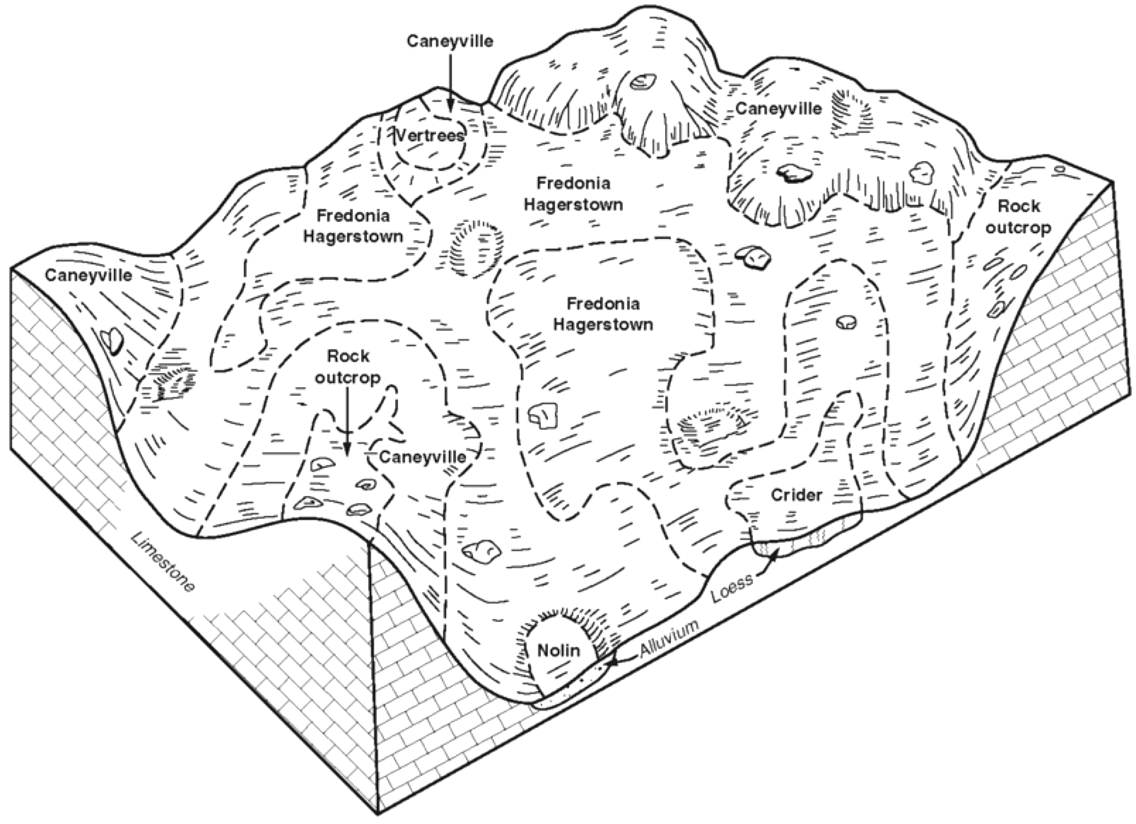
  44. KY-2012-01-30-16 | Hart County - May 1993

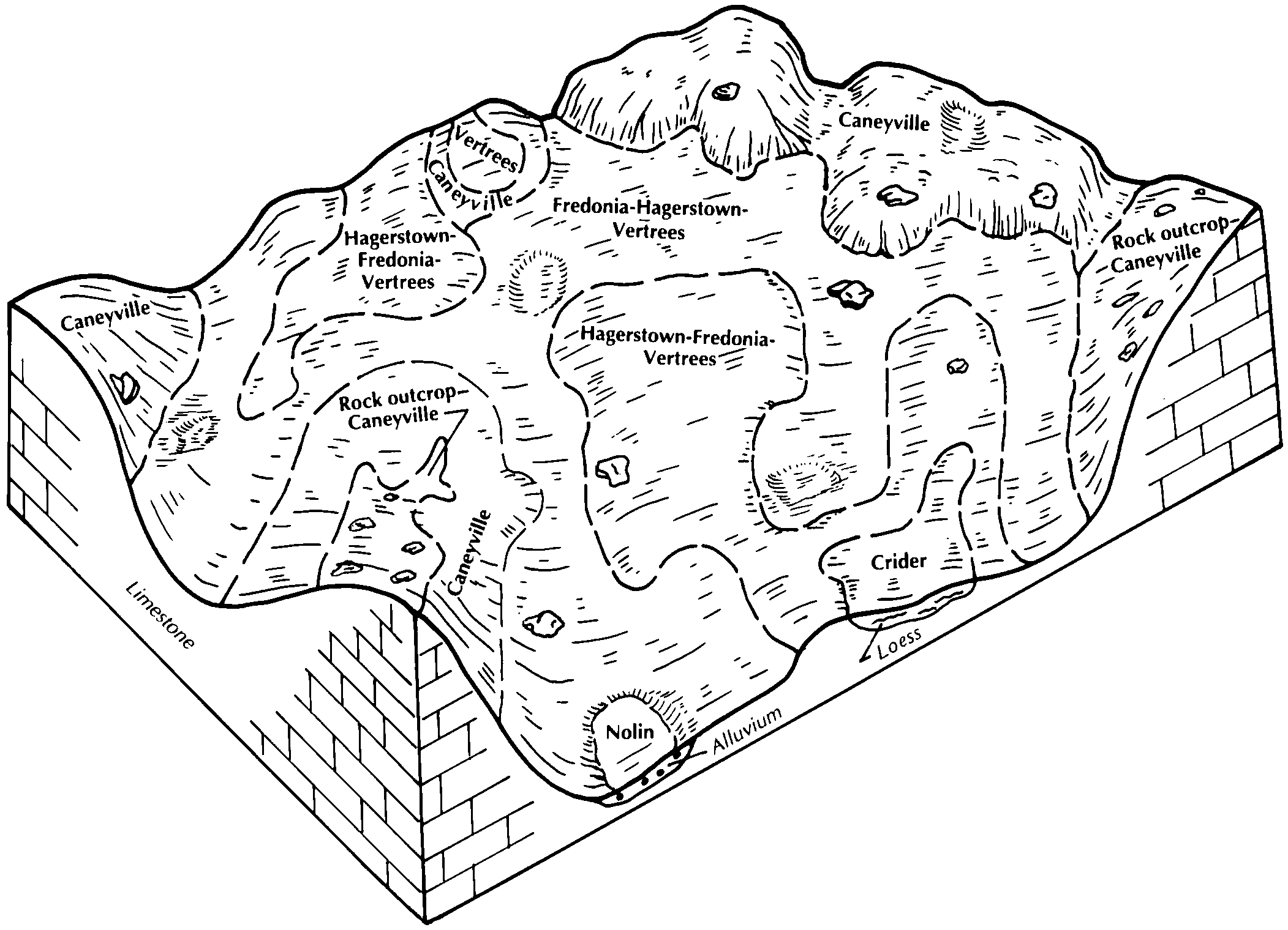
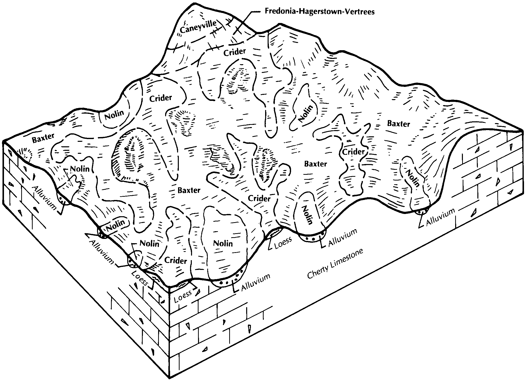
    Typical pattern of soils and underlying material in the Caneyville-Fredonia-Hagerstown general soil map unit (Soil Survey of Hart County, Kentucky; May 1993).

  45. KY-2012-01-30-17 | Hart County - May 1993

    Typical pattern of soils and underlying material in the Baxter-Crider general soil map unit (Soil Survey of Hart County, Kentucky; May 1993).

  46. KY-2012-01-30-18 | Hart County - May 1993

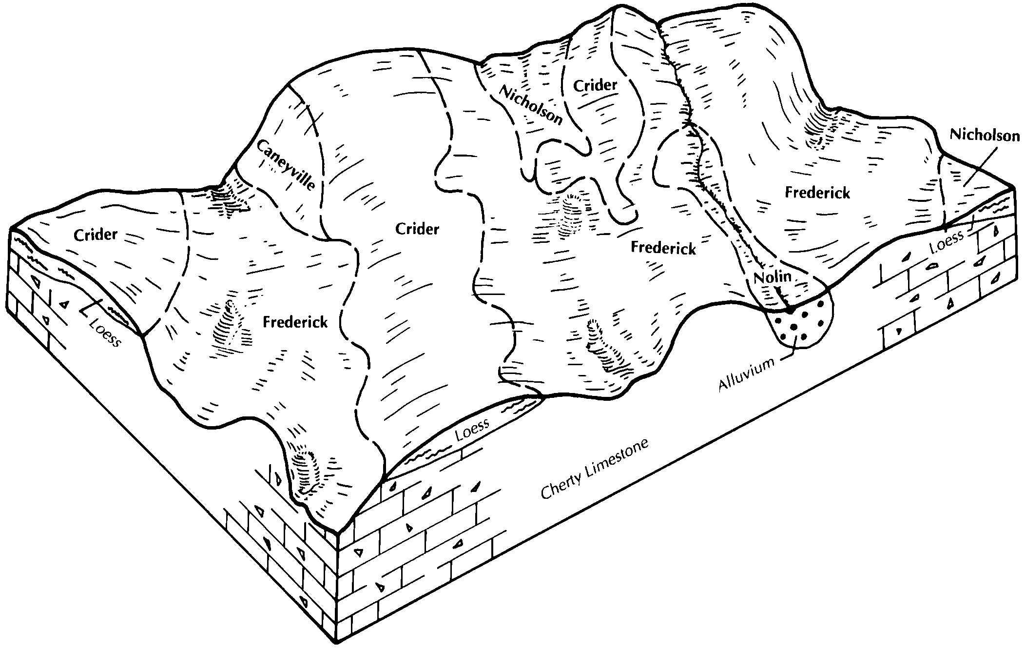
    Typical pattern of soils and underlying material in the Frederick-Crider general soil map unit (Soil Survey of Hart County, Kentucky; May 1993).

  47. KY-2012-01-30-19 | Hart County - May 1993

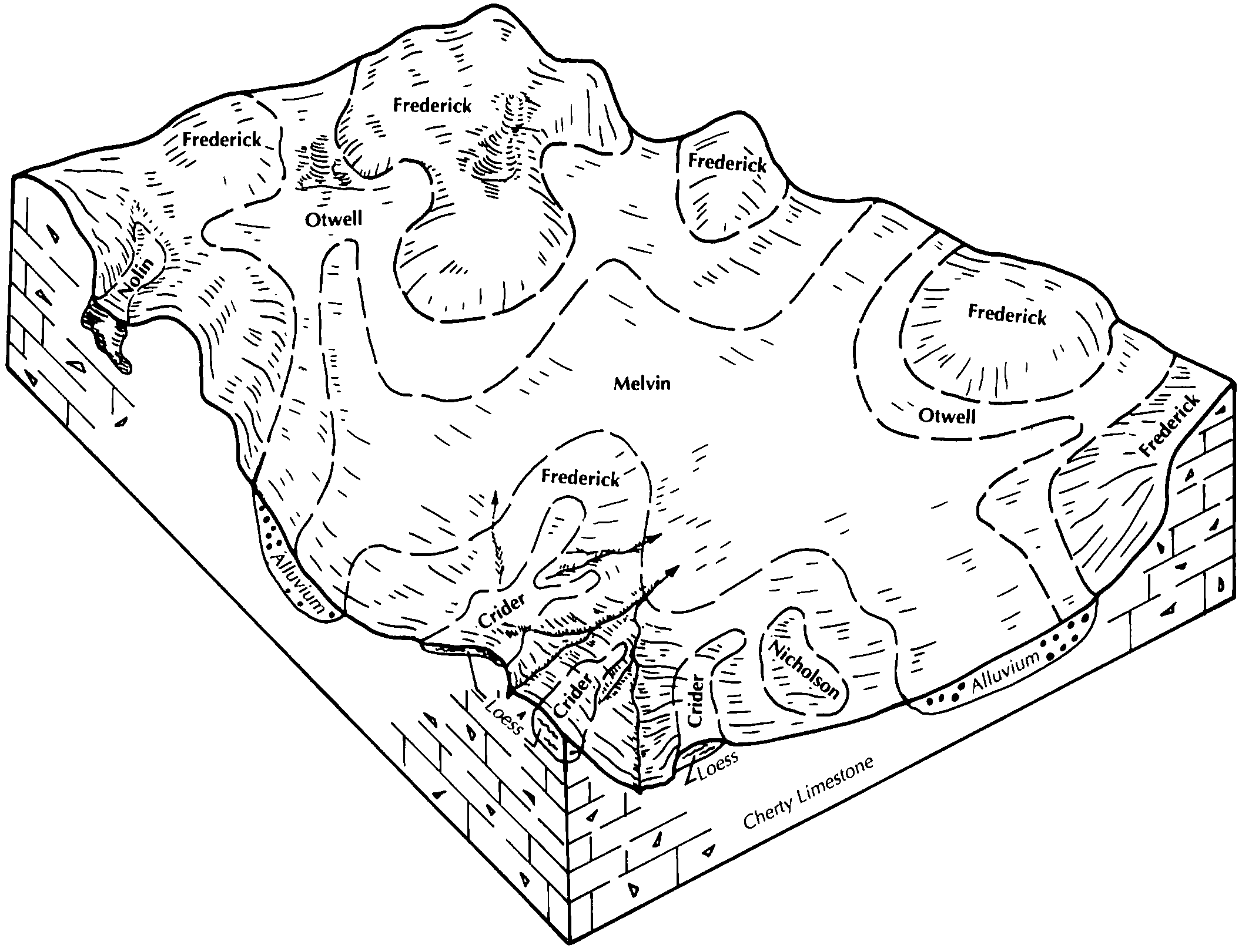
    Typical pattern of soils and underlying material in the Melvin-Frederick-Otwell general soil map unit (Soil Survey of Hart County, Kentucky; May 1993).

  48. KY-2012-01-30-20 | Hart County - May 1993

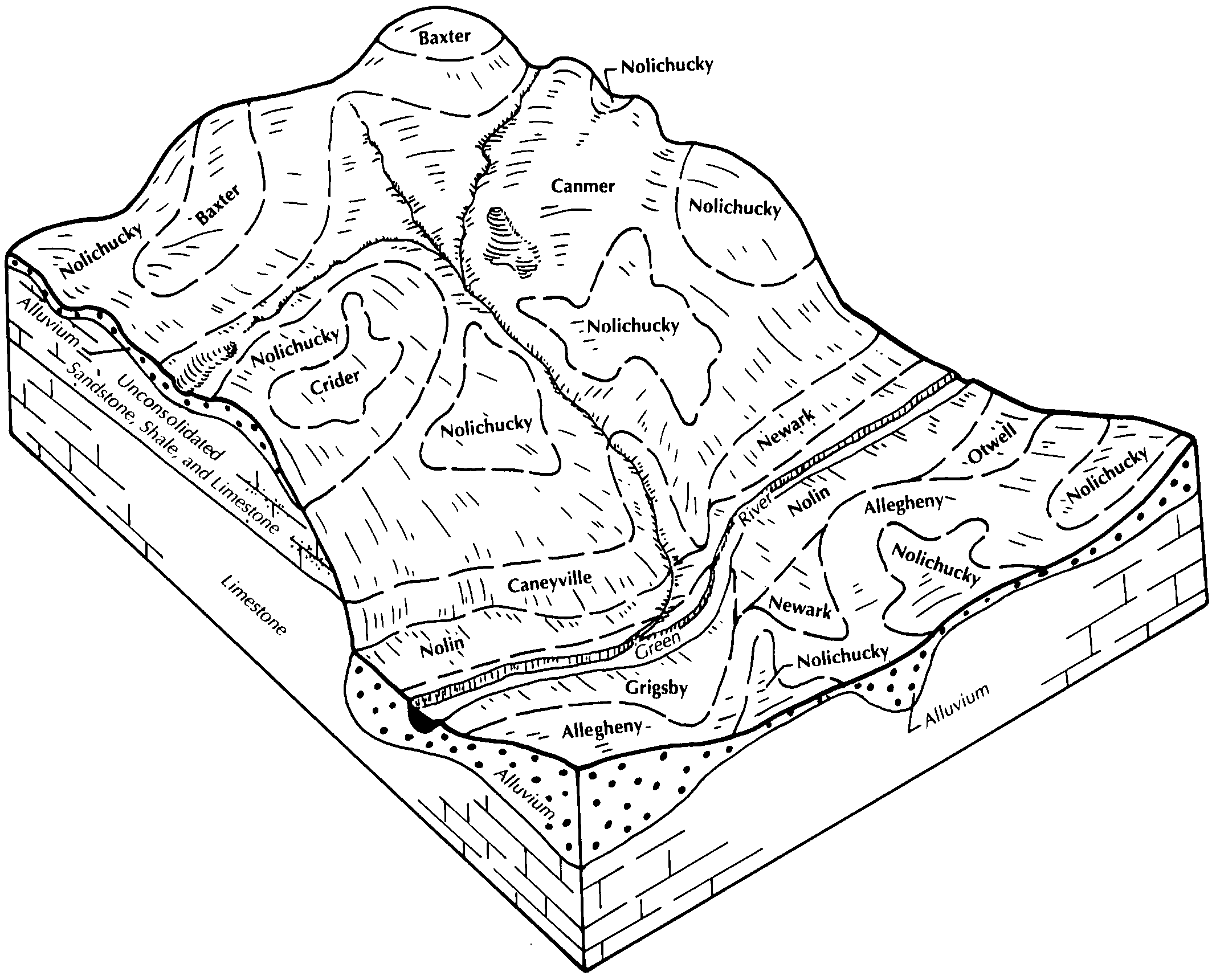
    Typical pattern of soils and underlying material in the Nolichucky-Canmer general soil map unit (Soil Survey of Hart County, Kentucky; May 1993).

  49. KY-2012-01-31-06 | Henry and Trimble Counties - April 1992

    Pattern of soils and parent material in the Faywood-Lowell-Fairmount general soil map unit in Henry County (Soil Survey of Henry and Trimble Counties, Kentucky; April 1992).

  50. KY-2012-01-31-07 | Henry and Trimble Counties - April 1992

    Pattern of soils and parent material in the Beasley-Nicholson general soil map unit in Henry County (Soil Survey of Henry and Trimble Counties, Kentucky; April 1992).

  51. KY-2012-02-01-01 | Livingston County - September 1993

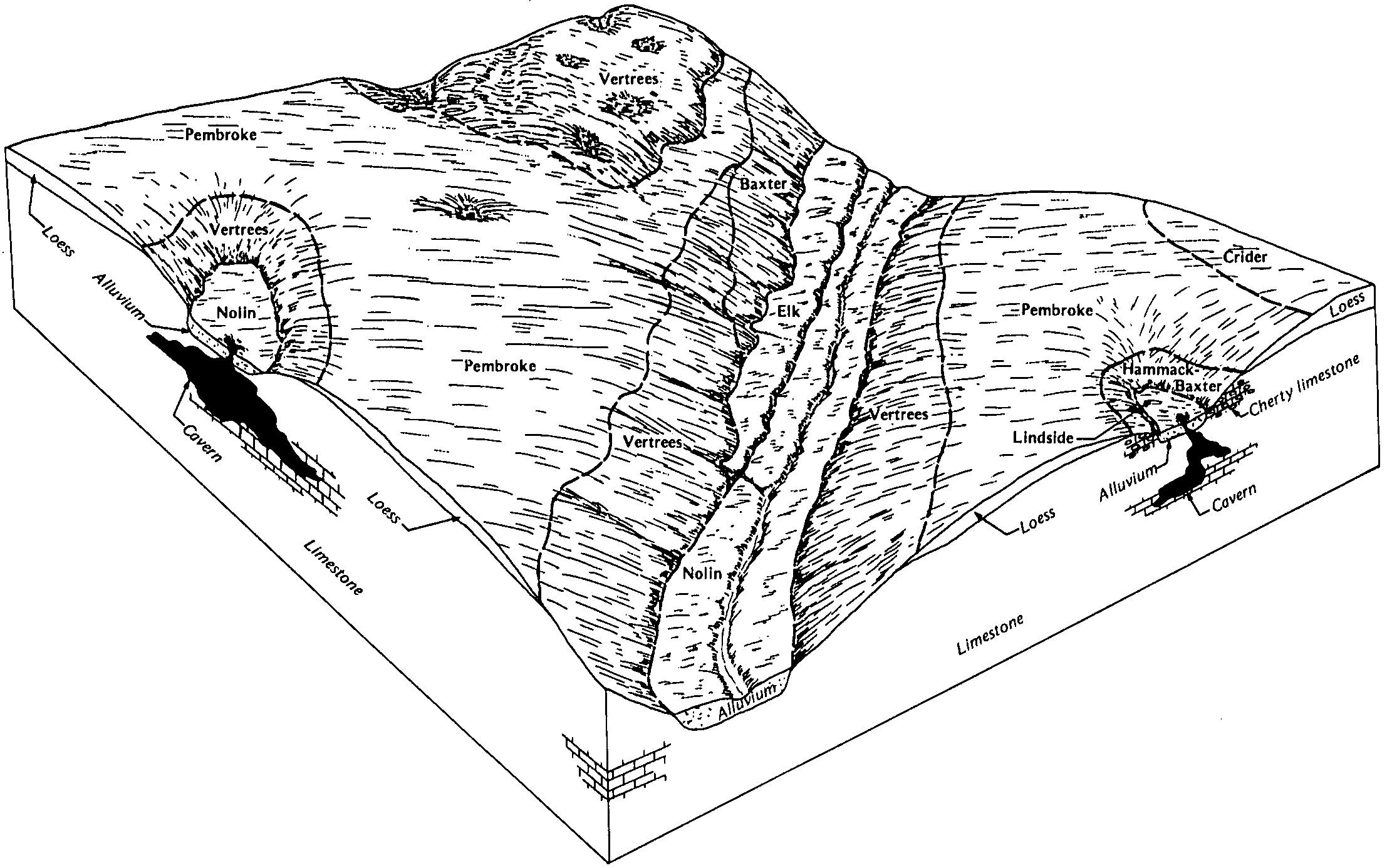
    Relationship of soils to topography and underlying material in the Huntington-Otwell-Lindside-Wheeling general soil map unit (Soil Survey of Livingston County, Kentucky; September 1993).

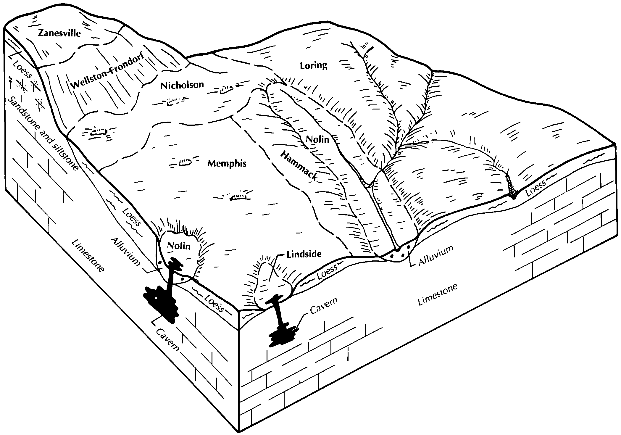
  52. KY-2012-02-01-03 | Livingston County - September 1993

    Relationship of soils to topography and underlying material in the Loring-Memphis-Nicholson general soil map unit (Soil Survey of Livingston County, Kentucky; September 1993).

  53. KY-2012-02-01-04 | Livingston County - September 1993

    Relationship of soils to topography and underlying material in the Baxter-Hammack-Loring general soil map unit (Soil Survey of Livingston County, Kentucky; September 1993).

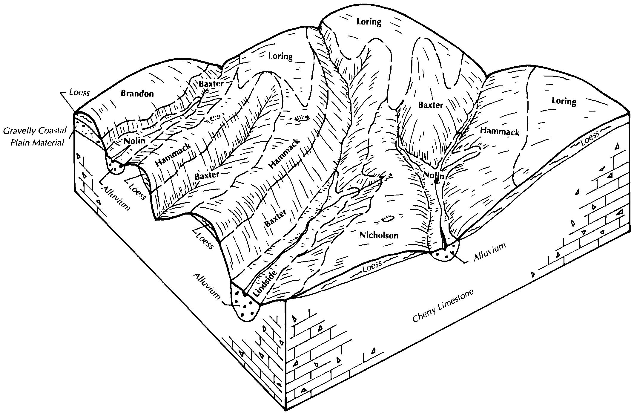
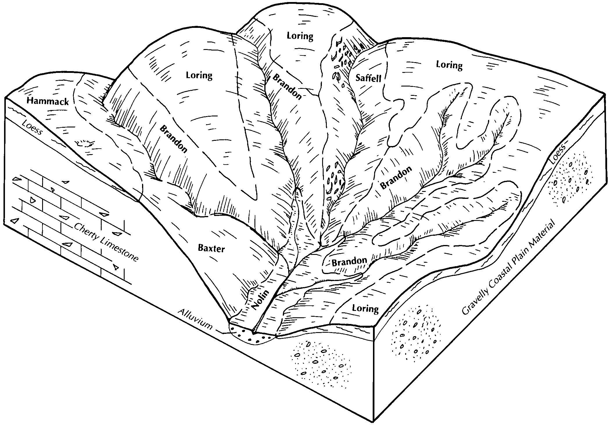
  54. KY-2012-02-01-05 | Livingston County - September 1993

    Relationship of soils to topography and underlying material in the Loring-Brandon-Saffell general soil map unit (Soil Survey of Livingston County, Kentucky; September 1993).

  55. KY-2012-02-01-12 | Marion County - August 1991

    Typical pattern of soils and parent material in the Lowell-Sandview-Faywood general soil map unit (Soil Survey of Marion County, Kentucky; August 1991).

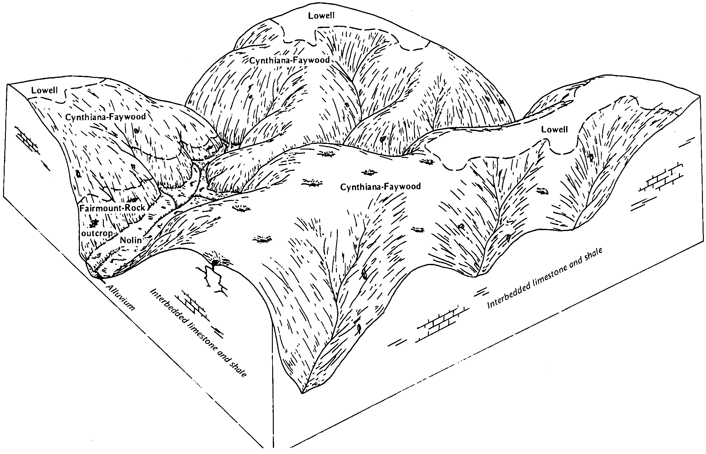
  56. KY-2012-02-01-14 | Mason County - September 1986

    Typical pattern of soils and parent material in the Eden-Lowell general soil map unit (Soil Survey of Mason County, Kentucky; September 1986).

  57. KY-2012-02-01-15 | Mason County - September 1986

    Typical pattern of soils and parent material in the Cynthiana-Faywood-Lowell general soil map unit (Soil Survey of Mason County, Kentucky; September 1986).

  58. KY-2012-02-01-46 | Pulaski County - December 1974

    Pattern of soils and underlying material in association 1 (Soil Survey of Pulaski County, Kentucky; December 1974).

  59. KY-2012-02-01-47 | Pulaski County - December 1974

    Pattern of soils and underlying material in association 2 (Soil Survey of Pulaski County, Kentucky; December 1974).

  60. KY-2012-02-01-49 | Pulaski County - December 1974

    Pattern of soils and underlying material in association 4 (Soil Survey of Pulaski County, Kentucky; December 1974).

  61. KY-2012-02-01-52 | Simpson County - May 1985

    Relationship of soils to topography and underlying material in the Pembroke-Bewleyville general soil map unit (Soil Survey of Simpson County, Kentucky; May 1985).

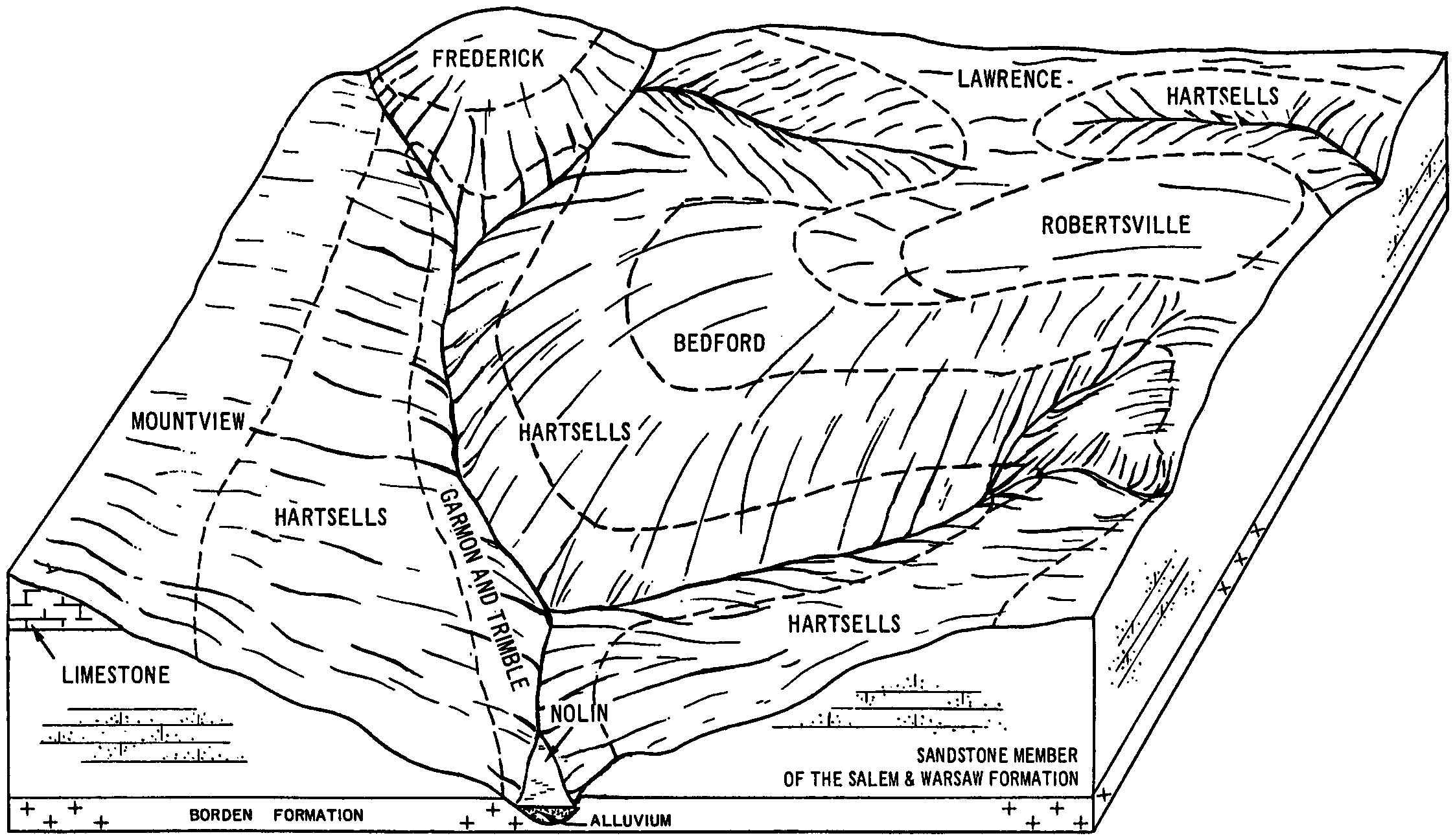
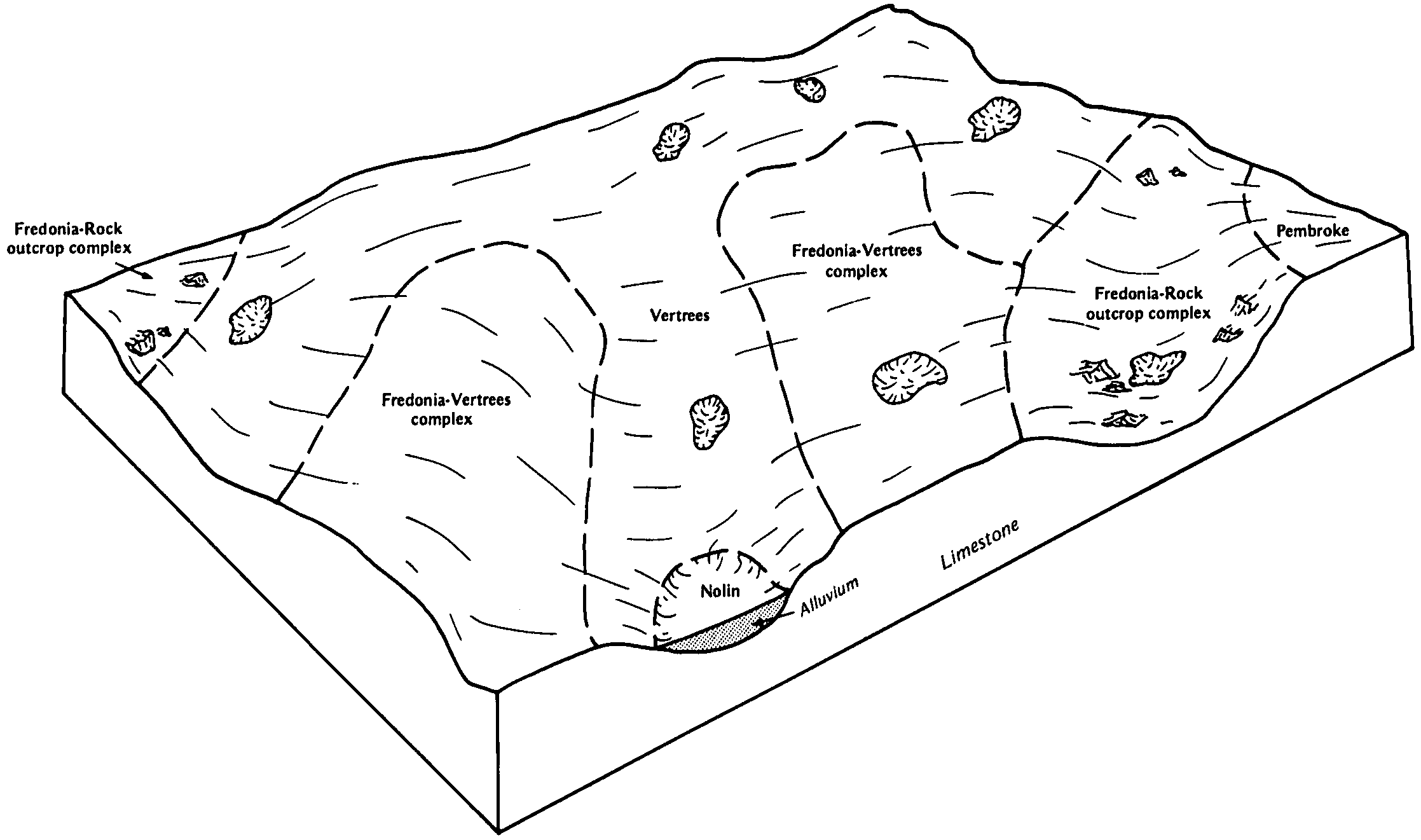
  62. KY-2012-02-01-53 | Simpson County - May 1985

    Relationship of soils to topography and underlying material in the Vertrees-Fredonia general soil map unit (Soil Survey of Simpson County, Kentucky; May 1985).

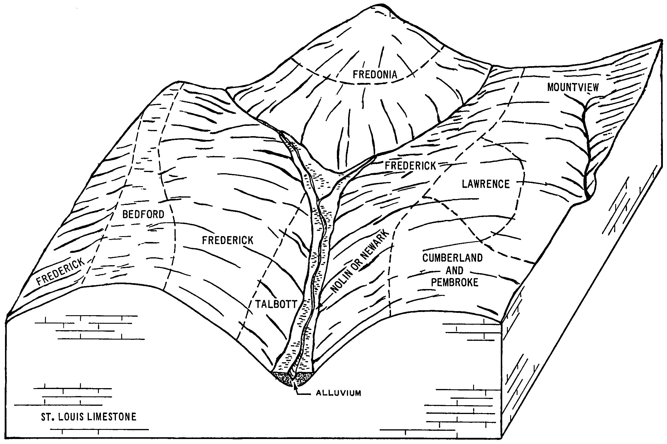
  63. KY-2012-02-01-55 | Simpson County - May 1985

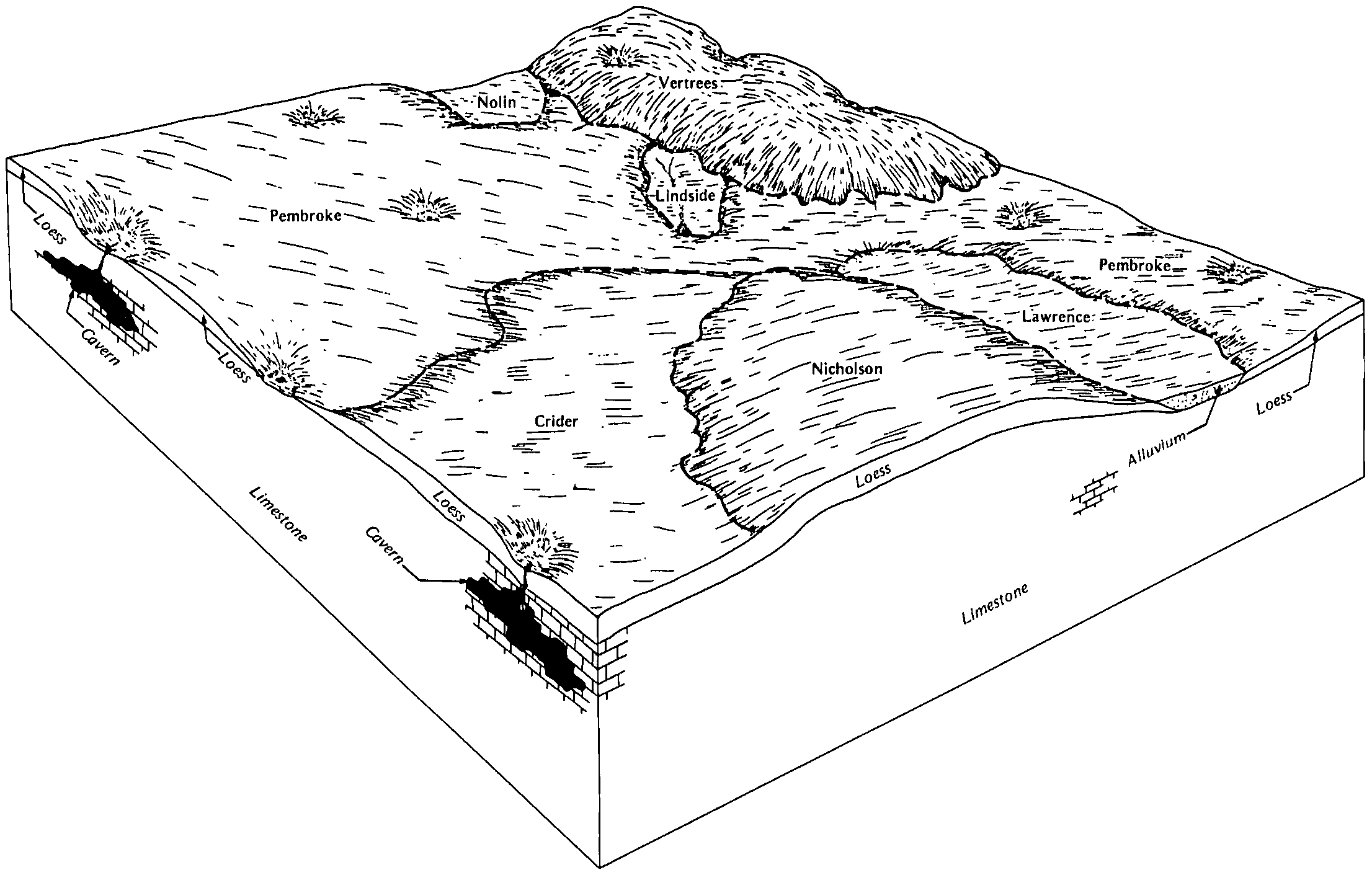
    Relationship of soils to topography and underlying material in the Nicholson-Lawrence-Robertsville general soil map unit (Soil Survey of asdSimpson County, Kentucky; May 1985).f

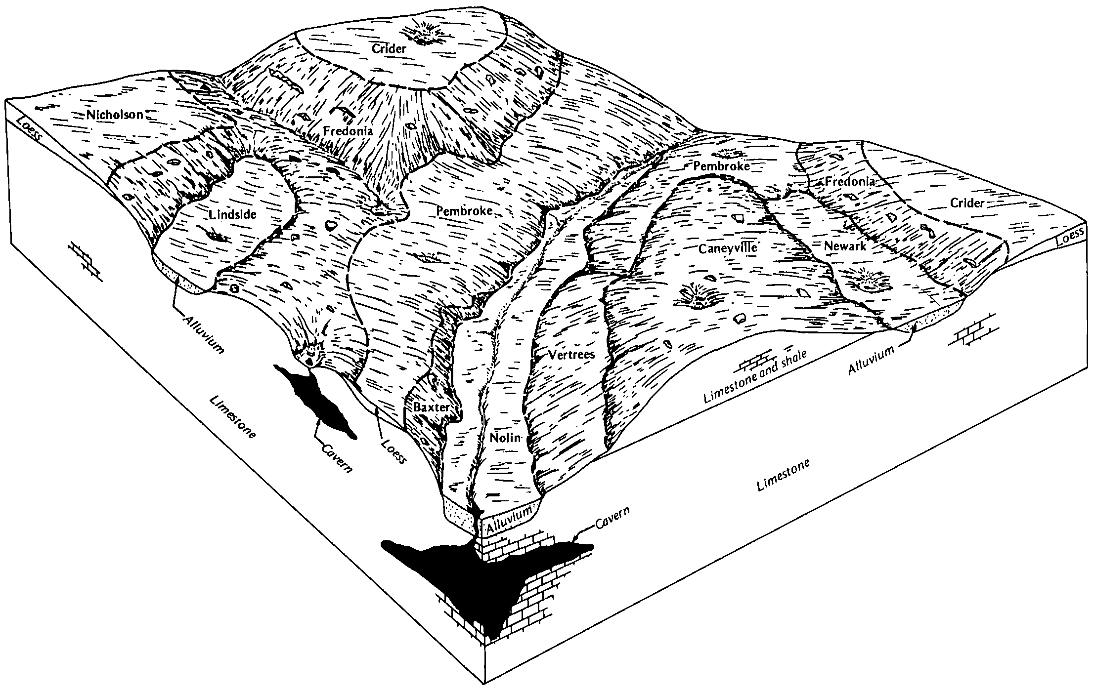
  64. KY-2012-02-01-59 | Todd County - September 1987

    Relationship of soils to topography and underlying material in the Fredonia-Pembroke-Caneyville map unit (Soil Survey of Todd County, Kentucky; September 1987).

  65. KY-2012-02-01-60 | Todd County - September 1987

    Relationship of soils to topography and underlying material in the Pembroke-Nicholson-Crider map unit (Soil Survey of Todd County, Kentucky; September 1987).

  66. KY-2012-02-01-61 | Todd County - September 1987

    Relationship of soils to topography and underlying material in the Hammack-Baxter-Crider map unit (Soil Survey of Todd County, Kentucky; September 1987).

  67. KY-2012-02-01-62 | Todd County - September 1987

    Relationship of soils to topography and underlying material in the Pembroke-Vertrees map unit (Soil Survey of Todd County, Kentucky; September 1987).

  68. KY-2012-02-01-65 | Washington County - August 1986

    Typical pattern of soils and underlying material in the Eden-Lowell map unit (Soil Survey of Washington County, Kentucky; August 1986).

  69. KY-2012-02-01-69 | Wayne County - March 1990

    The relationship of soils to topography and underlying material in the Decatur-Bewleyville-Clarksville general soil map unit (Soil Survey of Wayne County, Kentucky; March 1990).

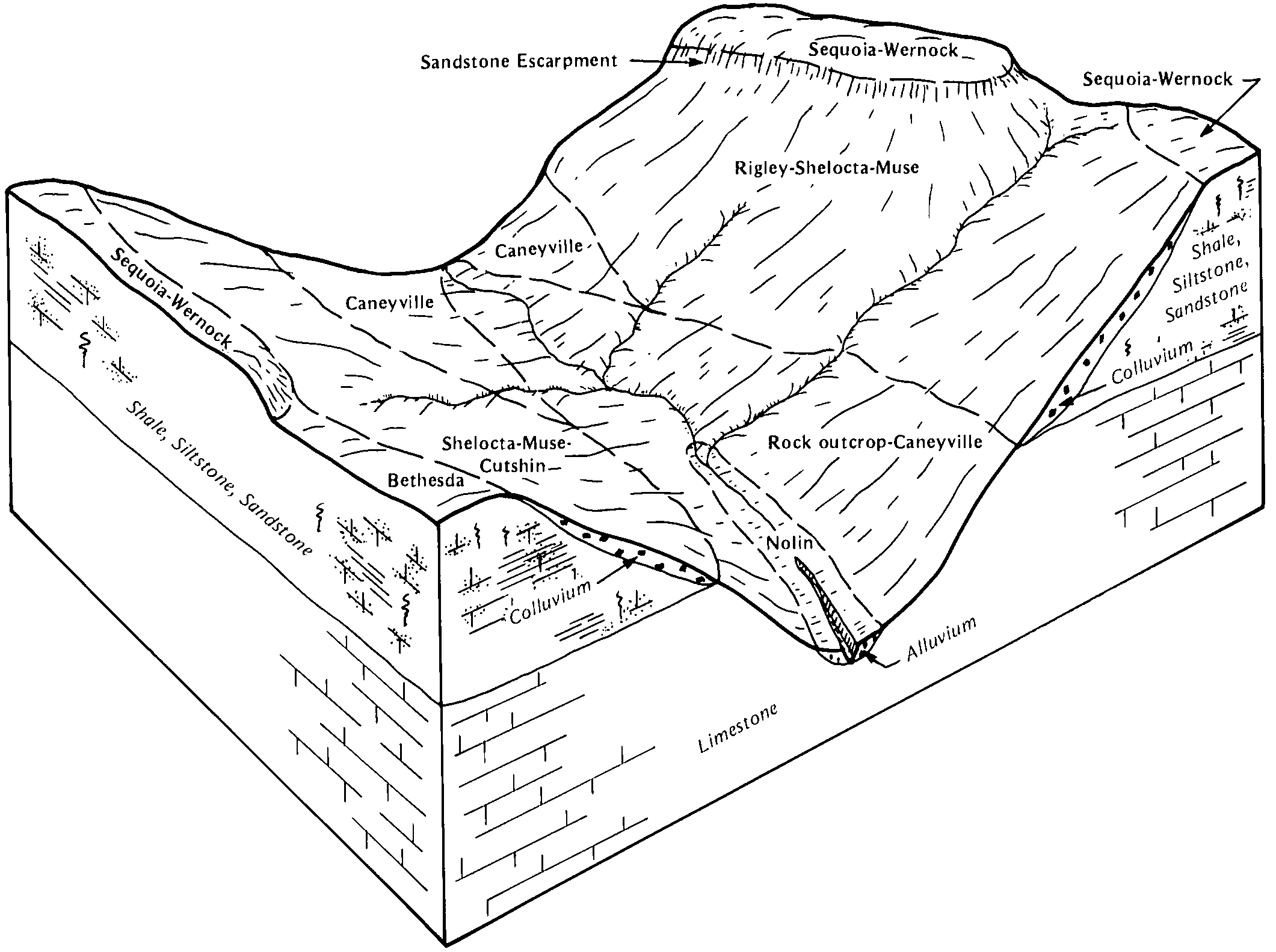
  70. KY-2012-02-01-70 | Wayne County - March 1990

    The relationship of soils to topography and underlying material in the Caneyville-Rock outcrop-Rigley-Shelocta general soil map unit (Soil Survey of Wayne County, Kentucky; March 1990).

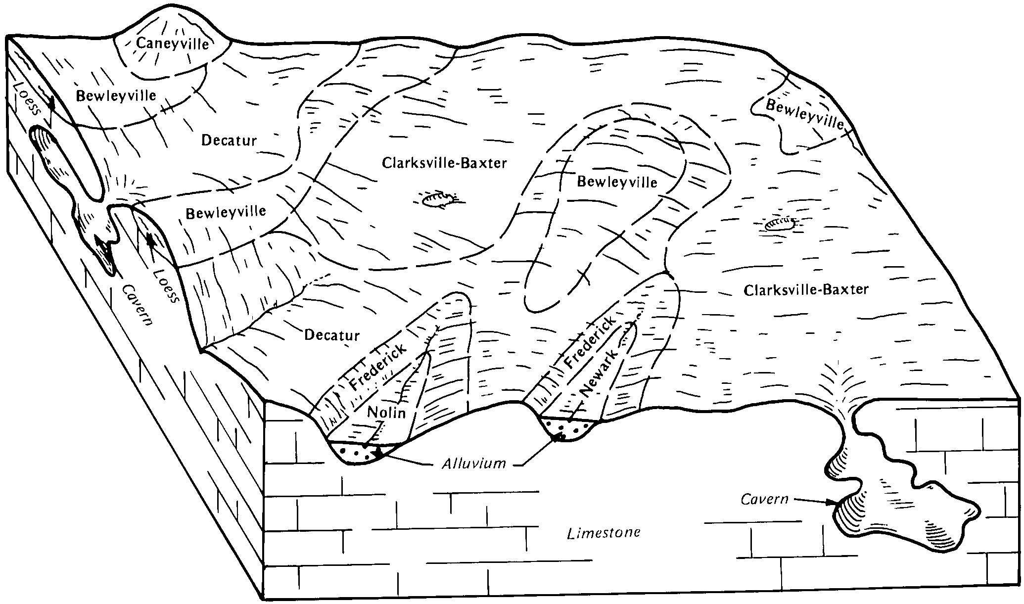
  71. KY-2012-05-09-02 | Mammoth Cave National Park - 2010

    Typical pattern of soils and underlying material in the Hagerstown-Fredonia general soil map unit (Soil Survey of Mammoth Cave National Park, Kentucky; 2010).

  72. KY-2012-05-09-03 | Mammoth Cave National Park - 2010

    Typical pattern of soils and underlying material in the Wellston-Clarkrange general soil map unit (Soil Survey of Mammoth Cave National Park, Kentucky; 2010).

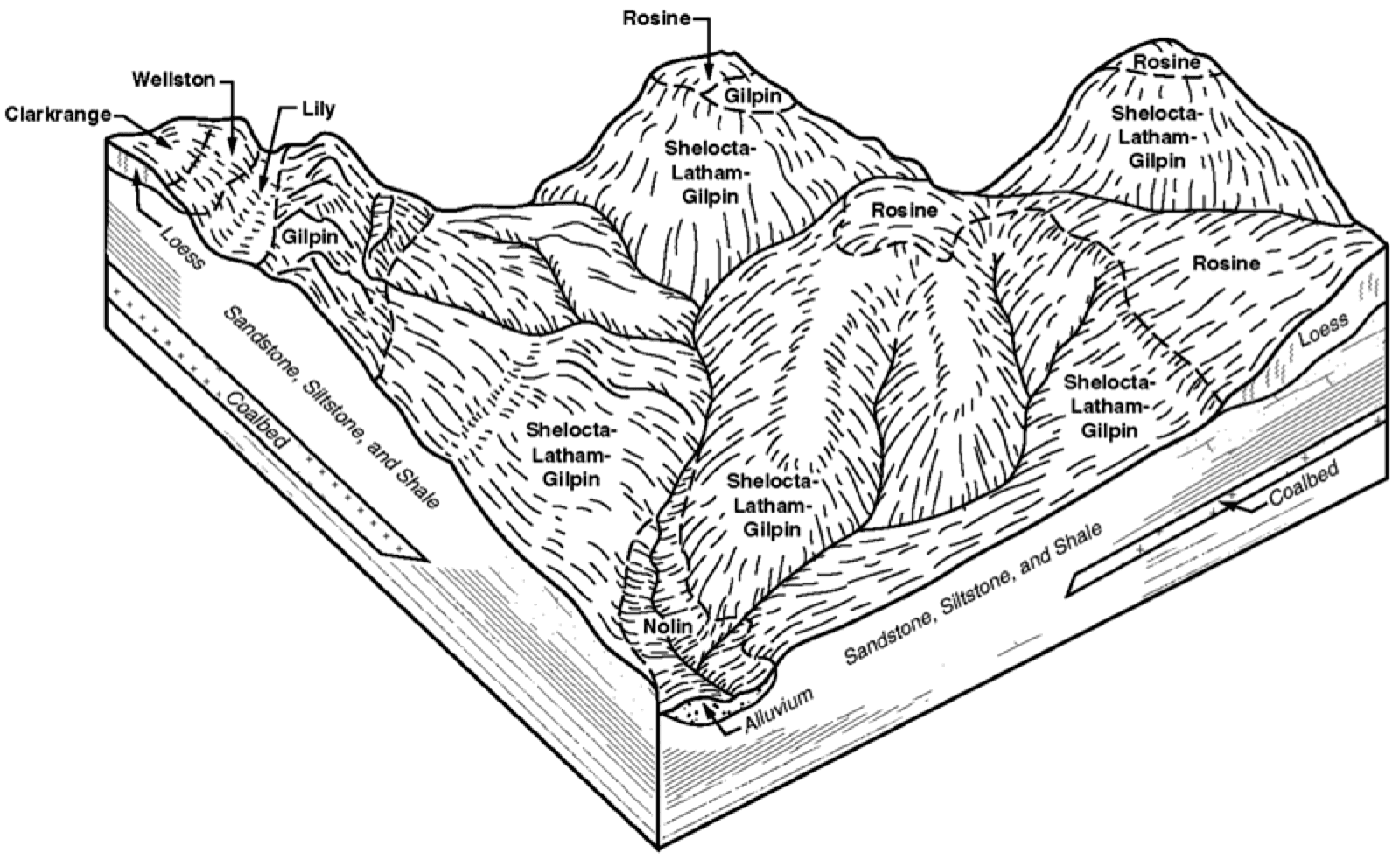
  73. KY-2012-05-09-05 | Mammoth Cave National Park - 2010

    Typical pattern of soils and underlying material in the Gilpin-Rosine-Shelocta general soil map unit (Soil Survey of Mammoth Cave National Park, Kentucky; 2010).

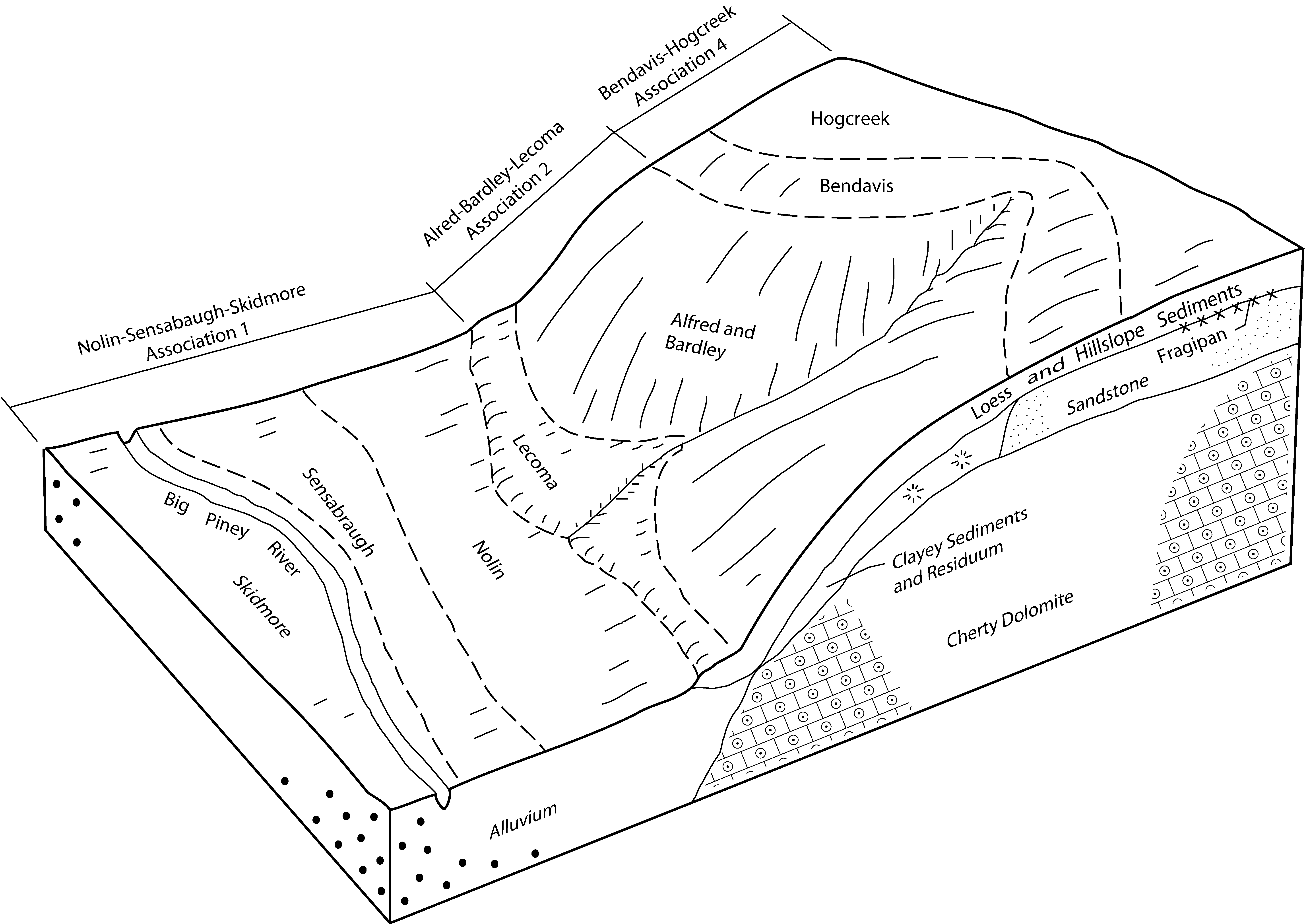
  74. MO-2010-09-27-05 | Texas County -

    Typical pattern of soils and parent material in the Bendavis-Hogcreek, Alred-Bardley-Lecoma, and Nolin-Sensabaugh-Skidmore associations (Soil Survey of Texas County, Missouri).

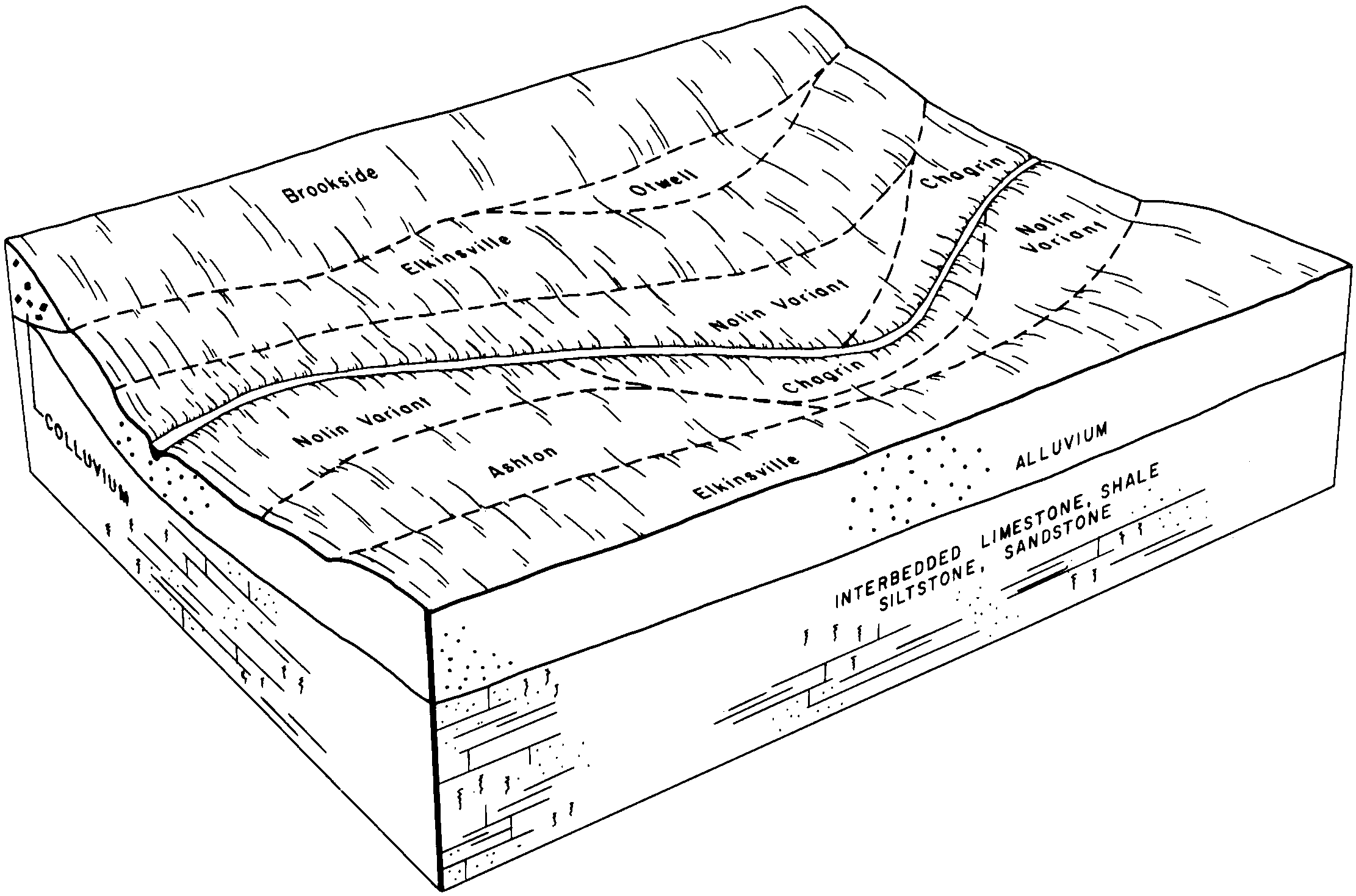
  75. OH-2012-02-16-15 | Belmont County - July 1981

    Typical pattern of soils in the Elkinsville-Nolin Variant-Brookside association (Soil Survey of Belmont County, Ohio; July 1981).

  76. PA-2012-03-13-10 | Centre County - August 1981

    Typical pattern of soils and underlying material in association 5 (Soil Survey of Centre County, PA; 1981).

  77. PA-2012-03-13-27 | Franklin County - August 1975

    Relationship of underlying material and topography in association 2 (Soil Survey of Franklin County, PA; 1975).

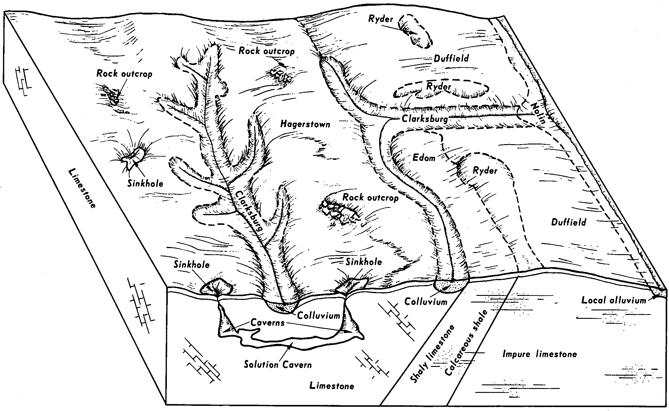
  78. PA-2012-03-13-52 | Lebanon County - August 1981

    Pattern of soils in the Hagerstown-Duffield-Clarksburg general soil map unit (Soil Survey of Lebanon County, PA; 1981).

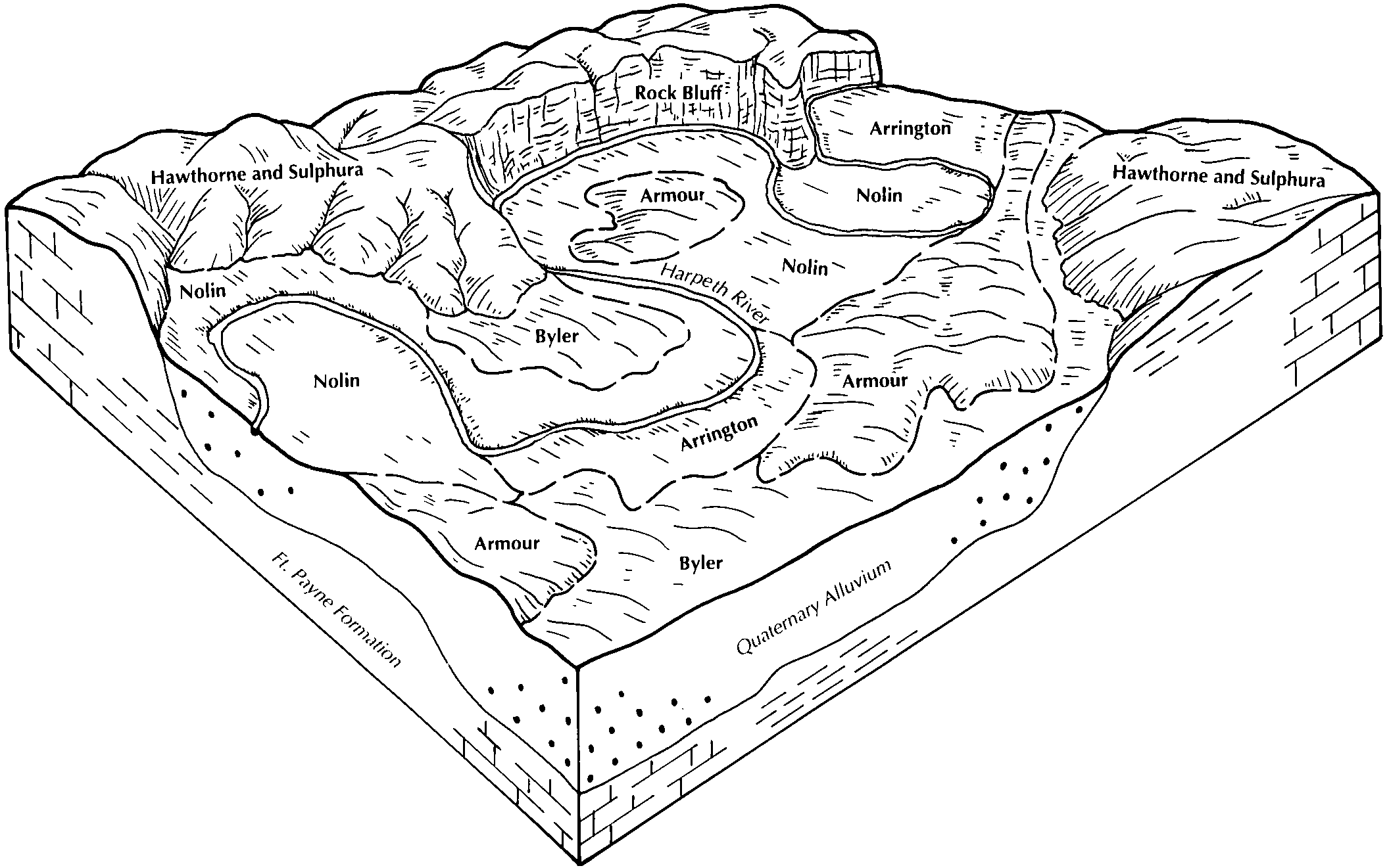
  79. TN-2012-03-16-03 | Cheatham County - 2002

    Relationship of soils to topography and the underlying material in the Byler-Nolin-Armour-Arrington general soil map unit. The Hawthorne and Suphura soils are adjacen to the map unit (Soil Survey of Cheatham County, TN; 2002).

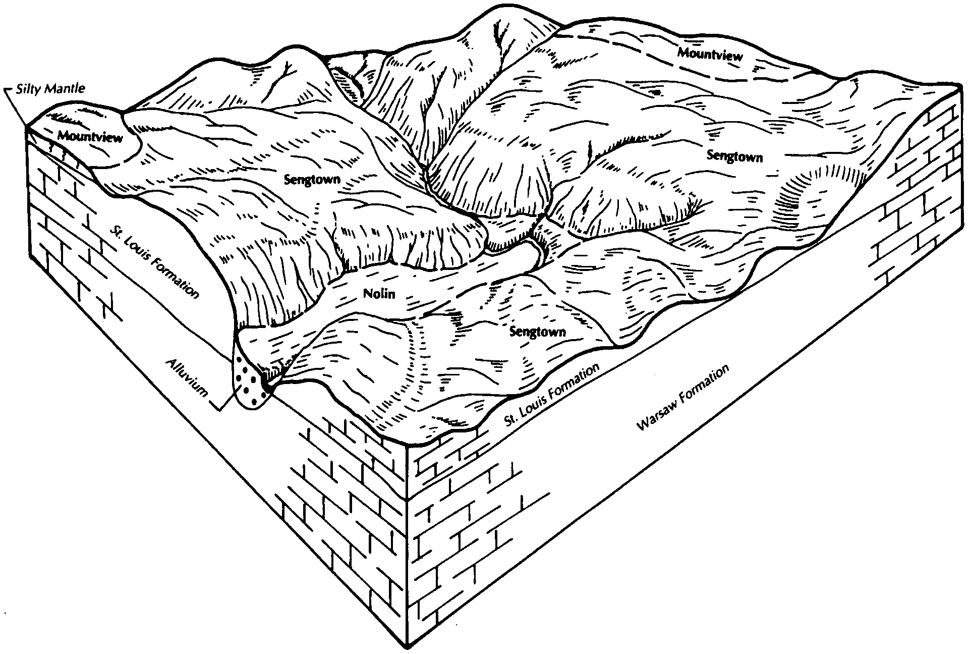
  80. TN-2012-03-16-04 | Dickson County - 2002

    The relationship of soils, landscape, and parent material in the Sengtown general soil map unit (Soil Survey of Dickson County, TN; 2002).

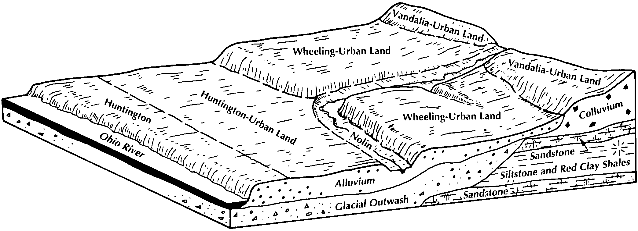
  81. WV-2012-03-23-07 | Wetzel County - September 1995

    Pattern of soils and parent material in the Huntington-Urban land-Wheeling general soil map unit (Soil Survey of Wetzel County, WV; 1995).

Map Units

Map units containing NOLIN as a major component. Limited to 250 records.

Map Unit Name Symbol Map Unit Area (ac) Map Unit Key National Map Unit Symbol Soil Survey Area Publication Date Map Scale
Nolin silty clay loam, 0 to 2 percent slopes, frequently flooded3601A525015439481ntlsil19320061:12000
Nolin silt loam, rarely floodedNo18741596195c30in02119801:15840
Nolin silty clay loam, rarely floodedNr7991596205c31in02119801:15840
Nolin silty clay loam, frequently floodedNo34961629645gkxin02719691:20000
Nolin silt loam, frequently floodedNo1278535637kzcmin03719781:15840
Nolin silt loam, frequently floodedNo77691601455cmzin05119861:15840
Nolin silt loam, protectedNn18461601445cmyin05119861:15840
Nolin silt loam, occasionally floodedNo17461615605f3min05519841:15840
Nolin silt loam, rarely floodedNr10221615615f3nin05519841:15840
Nolin silt loam, 0 to 2 percent slopes, rarely floodedNprAQ722185912120dknin06120071:12000
Nolin silty clay loam, rarely floodedNo103561644955j59in08319791:15840
Nolin silt loam, 0 to 2 percent slopes, frequently floodedNprAH476316515442s2c2in09319821:15840
Nolin silt loam, 0 to 2 percent slopes, frequently floodedNprAH254917081522s2c2in10119841:15840
Nolin silty clay loam, frequently floodedNo28321619245fhcin12519831:15840
Nolin silt loam, frequently floodedNo46614796421lnpdin13719821:15840
Nolin silt loam, 0 to 2 percent slopes, frequently floodedNo18225354962s2c2in17519841:15840
Nolin silt loam, occasionally floodedNo687515923981qg0pky00120061:12000
Nolin silt loam, occasionally floodedNo8175548767lf15ky00319861:20000
Skidmore-Nolin complex, frequently floodedSn4420548768lf16ky00319861:20000
Nolin silt loam, 0 to 4 percent slopes, frequently floodedNoA251317274522tggyky01120061:12000
Nolin silt loam, occasionally floodedNo315914047861j4spky03320051:12000
Nolin silt loam, pondedNp99214047881j4srky03320051:12000
Nolin silt loam, 0 to 3 percent slopes, occasionally floodedNo1625502542tggxky04319801:20000
Nolin silt loam, 0 to 2 percent slopes, occasionally floodedNo82205489052tm1sky04519891:20000
Nolin silt loamNo16245549069lfbxky04719771:20000
Nolin silt loam, frequently floodedNo3852551425lhsxky05319901:20000
Nolin silt loam, 0 to 2 percent slopes, occasionally floodedNn47065491382qyknky05519851:20000
Nolin silty clay loam, frequently floodedNo1392549139lff5ky05519851:20000
Nolin silt loam, 0 to 3 percent slopes, occasionally floodedNo65425527312tggxky06919891:20000
Nolin silt loam, 0 to 2 percent slopes, occasionally floodedNo28855496752qyknky08519671:20000
Nolin silt loam, 0 to 2 percent slopes, occasionally floodedNo417015327382tm1sky11120051:12000
Wheeling-Nolin complex, 2 to 30 percent slopesWnD2052550333lgnpky13519981:20000
Nolin silt loam, 0 to 3 percent slopes, occasionally floodedNo8545503142tggxky13519981:20000
Nolin silt loam, 0 to 2 percent slopes, frequently floodedNo52125493502s2c2ky13919891:20000
Nolin silt loamNo13662548726ldzvky14119721:20000
Nolin silt loam, 0 to 2 percent slopes, frequently floodedNo74705523602s2cxky15519861:20000
Nolin silt loam, 0 to 2 percent slopes, occasionally floodedNo45505489372tm1sky16119831:20000
Wheeling-Nolin silt loamsWn980548943lf6vky16119831:20000
Nolin silt loamNo4635549912lg73ky17119771:20000
Nolin silt loam, 0 to 2 percent slopes, occasionally floodedNo44325512652qyknky18319831:20000
Nolin silt loam, 0 to 2 percent slopes, frequently floodedNo27105515982s2cwky18519751:20000
Nolin silt loam, occasionally floodedNo243550046lgcfky19519861:24000
Nolin silt loamNo2424552446ljvvky19919691:12000
Nolin silt loamNo1630552499ljxkky20719791:20000
Nolin variant, fine sandy loamNv930552500ljxlky20719791:20000
Lowell-Nolin silt loams, 2 to 10 percent slopesLwB6564548868lf4fky20919741:15840
Nolin silt loam, 0 to 2 percent slopes, occasionally floodedNo51335488752tm1sky20919741:15840
Nolin silt loam, 0 to 2 percent slopes, occasionally floodedNo81305516662tm1sky21119781:20000
Nolin silt loamNo3760549807lg3qky21319821:20000
Nolin silt loam, occasionally floodedNo9530551172lhjrky21919841:20000
Nolin silt loam, frequently floodedNo13685553869llbrky22720041:12000
Nolin silt loam, pondedNp1675553828ll9fky22720041:12000
Nolin silt loam, 0 to 2 percent slopes, occasionally floodedNo66055515092tm1sky22919831:20000
Nolin silt loam, occasionally floodedNo5952550080lgdjky23119851:20000
Nolin silt loam, 0 to 2 percent slopes, occasionally floodedNo45845516402tm1sky60119821:20000
Huntington and Nolin silty clay loams, 0 to 2 percent slopes, frequently floodedHn640315927541qgd5ky60219721:12000
Nolin silt loam, 0 to 2 percent slopes, occasionally floodedNo53805520602tm1sky60319681:15840
Nolin silt loam, 0 to 2 percent slopes, frequently floodedNo147585521032s2cwky60419781:20000
Nolin silt loam, 0 to 4 percent slopes, frequently floodedNo7885504142tggyky60519751:20000
Nolin silt loam, 0 to 2 percent slopes, frequently floodedNo123185515592s2cwky60619791:20000
Nolin silt loam, 0 to 2 percent slopes, occasionally floodedNo97375496072qyknky60719921:20000
Nolin silt loam, depressional, frequently floodedNv2926549608lfx9ky60719921:20000
Nolin silt loam, 0 to 2 percent slopes, frequently floodedNo143705510082s2cwky60819831:20000
Huntington and Nolin soils, 0 to 2 percent slopes, frequently floodedHN75122322222dxt5ky61019681:12000
Nolin silt loamNo10021552004ljdlky61219721:15840
Boonesboro-Alluvial land complex (boonesboro-nolin)Bo2523551981ljcvky61219721:15840
Nolin silt loam, 0 to 2 percent slopes, frequently floodedNo114535529832s2cwky61819931:12000
Nolin silt loam, 0 to 2 percent slopes, occasionally floodedNo100605519692tm1sky61919781:15840
Nolin silt loam, 0 to 2 percent slopes, frequently floodedNw28355519702s2cwky61919781:15840
Nolin silt loamNo14668552571ljzwky62019791:20000
Nolin silt loam, 0 to 2 percent slopes, frequently floodedNo213905510562s2cxky62119751:20000
Nolin silt loam, 0 to 2 percent slopes, occasionally floodedNo47565519312tm1sky62219891:20000
Elk and Nolin silt loams, frequently floodedEn718551916lj9rky62219891:20000
Nolin silt loamNo1502552285ljpnky62819731:20000
Nolin silt loamNo26290549485lfsbky62919791:20000
Nolin-Elk complex, 0 to 6 percent slopes, occasionally flooded101373612215nk1wky63019661:15840
Nolin silt loam, 0 to 2 percent slopes, occasionally floodedNh31115511192qyknky63119761:20000
Nolin-Melvin complexNm787551120lhh2ky63119761:20000
Nolin silty clay loamNo8670549525lftmky63519781:20000
Nolin silt loam, 0 to 2 percent slopes, frequently floodedNo30615518512s2cwky63719891:12000
Nolin silt loam, occasionally floodedNo338924530932nbn1ky64719891:20000
Nolin silt loam, depressional, frequently floodedNp194124530942nbn2ky64719891:20000
Nolin silt loam, frequently floodedNo170423792052kvrkky64820091:12000
Nolin silt loam, pondedNp2323794102kvz5ky64820091:12000
Nolin silt loam, 0 to 2 percent slopes, frequently floodedNo948524528882s2c2ky70919951:20000
Nolin silt loam, 0 to 3 percent slopes, occasionally floodedNo151231701042tggxoh00119871:15840
Nolin silt loam, 0 to 3 percent slopes, frequently floodedNo7735373772tggwoh00919811:15840
Nolin silt loam, 0 to 3 percent slopes, occasionally floodedNo19905371142tggxoh01319781:15840
Nolin variant-Urban land complexNu345537115l0x9oh01319781:15840
Nolin silt loam, occasionally floodedNo24031697285pm3oh01519871:15840
Nolin silt loam, occasionally floodedNo524403442mxcsoh02519721:20000
Nolin silt loam, 0 to 3 percent slopes, occasionally floodedNo23325366762tggxoh03119961:15840
Nolin silt loam, rarely floodedNn765536675l0g3oh03119961:15840
Nolin silt loam, 0 to 3 percent slopes, frequently floodedNp1521089772tggwoh03119961:15840
Nolin silt loam, 0 to 2 percent slopes, occasionally floodedNoA5761721655s4qoh04319981:12000
Nolin silt loam, 0 to 3 percent slopes, occasionally floodedNo13975368262tggxoh05319881:15840
Nolin silt loam, 0 to 3 percent slopes, frequently floodedNo32225369402tggwoh05919981:15840
Nolin silt loam, occasionally floodedNo7641689555nt5oh06519871:15840
Nolin silt loam, 0 to 3 percent slopes, occasionally floodedNo18435367632tggxoh06719931:15840
Nolin silt loam, 0 to 3 percent slopes, frequently floodedNp1205367642tggwoh06719931:15840
Nolin silt loam, 0 to 3 percent slopes, occasionally floodedNo12414206722tggxoh07119731:15840
Nolin silt loam, 0 to 3 percent slopes, occasionally floodedNo16065361032tggxoh08119871:15840
Nolin silt loam, 0 to 3 percent slopes, occasionally floodedNo18285361622tggxoh08719891:15840
Nolin silt loam, occasionally floodedNo37731712095r4woh10119841:15840
Nolin silt loam, 0 to 3 percent slopes, frequently floodedNo8385371822tggwoh10519911:15840
Nolin silt loam, 0 to 3 percent slopes, frequently floodedNp33225374592tggwoh11519921:15840
Nolin silt loam, 0 to 3 percent slopes, occasionally floodedNo915374582tggxoh11519921:15840
Nolin silt loam, 0 to 3 percent slopes, occasionally floodedNo51375379272tggxoh11919891:15840
Urban land-Nolin complex, rarely floodedUtA552537944l1s1oh11919891:15840
Nolin silt loam, rarely floodedNn314256571jvhyoh11919891:15840
Nolin silt loam, 0 to 3 percent slopes, frequently floodedNo49445370282tggwoh12119861:15840
Nolin silt loam, 0 to 3 percent slopes, occasionally floodedNo19125375662tggxoh12719841:15840
Nolin silt loam, 0 to 3 percent slopes, occasionally floodedNo120865372702tggxoh14519841:15840
Nolin silt loam, 0 to 3 percent slopes, occasionally floodedNo41115363272tggxoh15719811:15840
Nolin silt loam, 0 to 2 percent slopes, occasionally floodedNo3514061401j66coh15919701:15840
Nolin silt loam, 0 to 3 percent slopes, occasionally floodedNo8635365362tggxoh16719731:15840
Nolin silt loamNd722541843l5ttpa00919891:24000
Nolin silt loam, local alluvium, 0 to 5 percent slopesNo4943538334l25mpa02719751:20000
Nolin silt loamNe2504542785l6t6pa07119821:15840
Nolin variant silt loamNo1489541322l590pa07519761:20000
Nolin silt loamNo2451545526l9nmpa60519751:20000
Nolin silt loam, occasionally floodedNo3680527025kpdttn02119911:24000
Nolin silt loam, occasionally floodedNo556636863pcpztn02720021:24000
Nolin silt loam, occasionally floodedNo1743527120kphwtn04319931:24000
Nolin silt loam, occasionally floodedNo1511525496kmthtn08919911:24000
Nolin silt loam, occasionally floodedHh323123969192lg5ztn16119531:20000
Nolin silt loam, 0 to 2 percent slopes, occasionally floodedNo250631604491kyz7tn16119531:20000
Nolin silt loam, occasionally pondedAa28023968712lg4ftn16119531:20000
Nolin silt loam, occasionally floodedNo4010528377kqtftn16519931:20000
Ennis silt loam, local alluviumEn166124274342mgybtn61019601:15840
Lindside-Nolin silt loams172288521251khdkva15519811:15840
Nolin silt loamNo713553006lkfxwv02520021:24000
Nolin loamNo3773513715k7kgwv10319881:24000
Nolin silt loam, 0 to 3 percent slopes, occasionally floodedNo6615158222tggxwv61019731:20000

Map of Series Extent

Approximate geographic distribution of the NOLIN soil series. To learn more about how this distribution was mapped, or to compare this soil series extent to others, use the Series Extent Explorer (SEE) application. Source: generalization of SSURGO geometry .