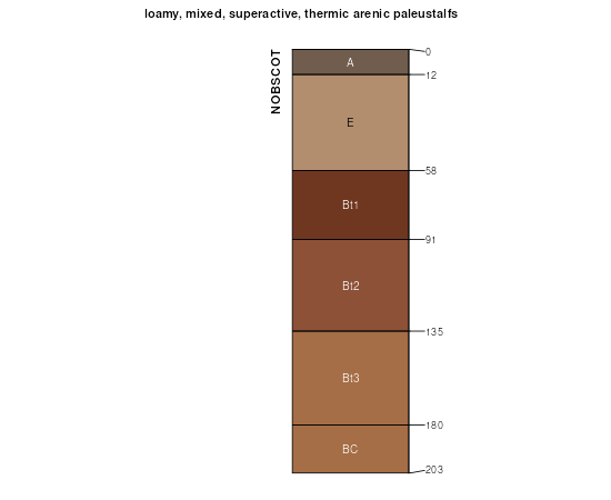
| Nobscot sand, 0 to 5 percent slopes | 36 | 50289 | 381673 | 2t6p9 | ok009 | 1978 | 1:24000 |
Delwin-Nobscot complex, 0 to 3 percent slopes | 15 | 41739 | 381650 | dt49 | ok009 | 1978 | 1:24000 |
Nobscot sand, 5 to 20 percent slopes | 37 | 3975 | 381674 | 2t6pn | ok009 | 1978 | 1:24000 |
Nobscot and Delwin soils, 2 to 5 percent slopes, gullied | 38 | 3011 | 381675 | dt53 | ok009 | 1978 | 1:24000 |
Nobscot sand, 0 to 5 percent slopes | NstC | 36577 | 381750 | 2t6p9 | ok011 | 1965 | 1:24000 |
Nobscot sand, 5 to 20 percent slopes | NcD | 1882 | 381752 | 2t6pn | ok011 | 1965 | 1:24000 |
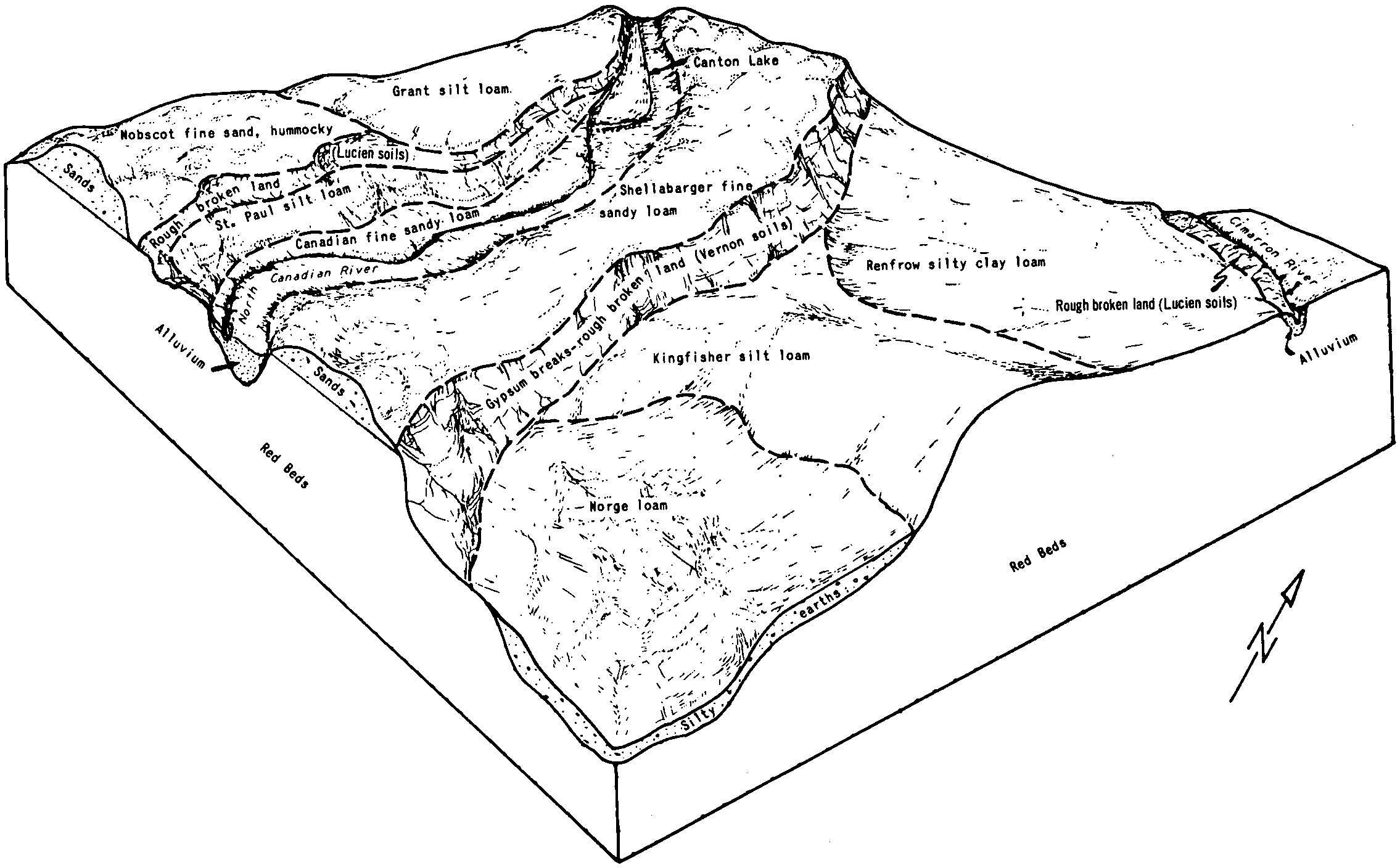
Nobscot sand, 5 to 20 percent slopes | NoE | 36711 | 382383 | 2t6pn | ok043 | 1961 | 1:24000 |
Nobscot-Grandfield complex, 0 to 5 percent slopes | NpC | 19964 | 382384 | dtwz | ok043 | 1961 | 1:24000 |
Nobscot and Grandfield soils, 3 to 12 percent slopes, severely eroded | Er | 2966 | 382370 | dtwj | ok043 | 1961 | 1:24000 |
Nobscot-Delwin complex, 1 to 5 percent slopes | NbC | 63737 | 382449 | dtz2 | ok045 | 1963 | 1:24000 |
Nobscot sand, 5 to 20 percent slopes | NoE | 42726 | 382451 | 2t6pn | ok045 | 1963 | 1:24000 |
Nobscot-Delwin complex, 3 to 8 percent slopes, severely eroded MLRA 78C | Nc3 | 2592 | 382450 | 2t6pr | ok045 | 1963 | 1:24000 |
Nobscot fine sand, 2 to 5 percent slopes, severely eroded | Bg | 638 | 382420 | dty4 | ok045 | 1963 | 1:24000 |
Nobscot sand, 0 to 5 percent slopes | NstC | 4155 | 653901 | 2t6p9 | ok055 | 2005 | 1:24000 |
Nobscot sand, 5 to 20 percent slopes | 46 | 2441 | 975480 | 2t6pn | ok057 | 1982 | 1:24000 |
Nobscot sand, 0 to 5 percent slopes | 45 | 1910 | 975479 | 2t6p9 | ok057 | 1982 | 1:24000 |
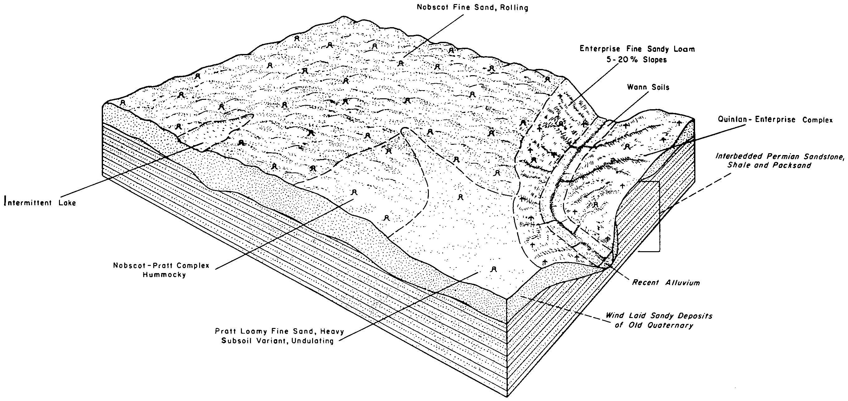
Nobscot sand, 5 to 20 percent slopes | NcD | 72766 | 383841 | 2t6pn | ok093 | 1965 | 1:24000 |
Nobscot sand, 0 to 5 percent slopes | NcC | 20045 | 383840 | 2t6p9 | ok093 | 1965 | 1:24000 |
Nobscot-Eda complex, 5 to 20 percent slopes | NpD | 11064 | 383843 | 2t6pp | ok093 | 1965 | 1:24000 |
Nobscot-Eda complex, 3 to 5 percent slopes | NpC | 3246 | 383842 | 2t6pq | ok093 | 1965 | 1:24000 |
Nobscot and Delwin soils, 3 to 8 percent slopes | NbC | 43337 | 384756 | dxch | ok129 | 1961 | 1:24000 |
Nobscot and Delwin soils, 0 to 3 percent slopes | NbB | 42739 | 384755 | dxcg | ok129 | 1961 | 1:24000 |
Nobscot sand, 0 to 5 percent slopes | NaB | 26828 | 384754 | 2t6p9 | ok129 | 1961 | 1:24000 |
Nobscot, Delwin, and Grandfield soils, 3 to 8 percent slopes, severely eroded | Er | 22776 | 384738 | dxbx | ok129 | 1961 | 1:24000 |
Grandfield-Nobscot complex, 8 to 15 percent slopes | MnE | 19273 | 384752 | 30l0f | ok129 | 1961 | 1:24000 |
Grandfield-Nobscot complex, 5 to 8 percent slopes | MnD | 8550 | 384751 | 30l0d | ok129 | 1961 | 1:24000 |
Nobscot and Delwin soils, 3 to 8 percent slopes, eroded | Nc2 | 2662 | 384757 | dxcj | ok129 | 1961 | 1:24000 |
Nobscot-Eufaula complex, 5 to 12 percent slopes | NeD | 23685 | 385285 | dxxk | ok153 | 1961 | 1:24000 |
Nobscot-Eda complex, 5 to 20 percent slopes | NpE | 18057 | 385287 | 2t6pp | ok153 | 1961 | 1:24000 |
Nobscot-Delwin complex, 3 to 5 percent slopes | NbC | 15534 | 385283 | dxxh | ok153 | 1961 | 1:24000 |
Nobscot-Eda complex, 3 to 5 percent slopes | NpC | 5148 | 385286 | 2t6pq | ok153 | 1961 | 1:24000 |
Nobscot-Delwin complex, 3 to 8 percent slopes, severely eroded MLRA 78C | Nc3 | 1378 | 385284 | 2t6pr | ok153 | 1961 | 1:24000 |
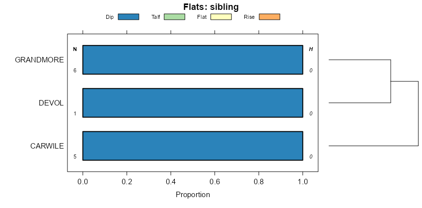
Devol and Nobscot soils, severely eroded | Sn3 | 8394 | 363841 | d6lt | tx075 | 1961 | 1:20000 |
Devol and Nobscot soils, hummocky | SnD | 5769 | 363842 | d6lv | tx075 | 1961 | 1:20000 |
Heatly-Nobscot complex, 0 to 5 percent slopes | Bn | 10752 | 364094 | 2vt8d | tx087 | 1965 | 1:20000 |
Nobscot fine sand | No | 15880 | 364606 | d7dh | tx101 | 1969 | 1:20000 |
Heatly-Nobscot complex, 0 to 5 percent slopes | BW | 53226 | 365109 | 2vt8d | tx125 | 1965 | 1:20000 |
Nobscot fine sand, 1 to 8 percent slopes | Nb | 2764 | 365191 | d80c | tx129 | 1975 | 1:24000 |
Nobscot fine sand, 0 to 5 percent slopes | NoC | 5250 | 378345 | dppp | tx169 | 1965 | 1:24000 |
Nobscot fine sand | Nb | 2530 | 366953 | d9v6 | tx191 | 1965 | 1:20000 |
Nobscot fine sand, undulating | No | 2100 | 367152 | db1m | tx197 | 1965 | 1:20000 |
Devol-Nobscot complex, 1 to 3 percent slopes | DeNB | 16688 | 2713435 | 2r5rx | tx207 | 1960 | 1:20000 |
Nobscot-Devol complex, 3 to 8 percent slopes | NoDC | 5055 | 2713443 | 2r5ry | tx207 | 1960 | 1:20000 |
Tivoli-Nobscot complex, 5 to 15 percent slopes | TvND | 694 | 2713444 | 2r5rz | tx207 | 1960 | 1:20000 |
Nobscot fine sand | No | 12702 | 368243 | dc5t | tx253 | 1966 | 1:20000 |
Nobscot soils and blown-out land | Ns | 959 | 368244 | dc5v | tx253 | 1966 | 1:20000 |
Heatly-Nobscot complex, 0 to 5 percent slopes | Nb | 101131 | 368491 | 2vt8d | tx263 | 1968 | 1:31680 |
Nobscot and Tivoli soils, undulating | NtB | 418 | 368492 | dcfv | tx263 | 1968 | 1:31680 |
Nobscot sand, 1 to 5 percent slopes | NoC | 2692 | 368600 | dckb | tx269 | 1999 | 1:31680 |
Devol-Nobscot complex, 1 to 3 percent slopes | DeNB | 5500 | 2713436 | 2r5rx | tx275 | 1975 | 1:24000 |
Nobscot soils, 3 to 12 percent slopes | NoE | 10276 | 370882 | dfxy | tx345 | 1972 | 1:24000 |
Nobscot association | NS | 49086 | 372290 | dhdc | tx433 | 1970 | 1:24000 |
Devol-Nobscot complex, 1 to 3 percent slopes | DeNB | 69 | 2713437 | 2r5rx | tx433 | 1970 | 1:24000 |
Nobscot sand, 0 to 5 percent slopes | PtB | 50577 | 373323 | 2t6p9 | tx483 | 1970 | 1:24000 |