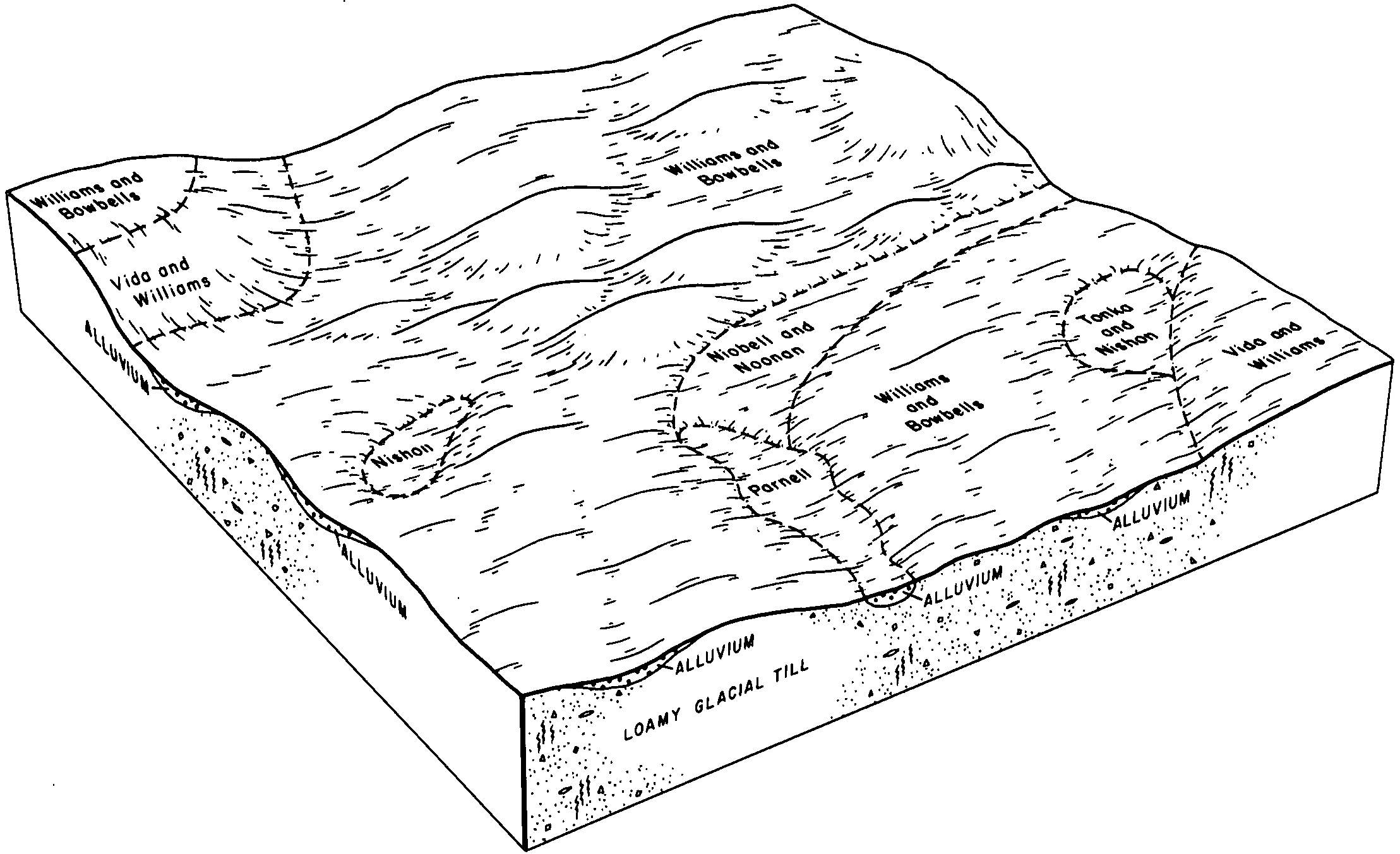
| Williams-Niobell loams, 0 to 3 percent slopes | 2023 | 61198 | 341101 | cfy8 | nd013 | 1991 | 1:24000 |
Noonan-Niobell loams, 0 to 6 percent slopes | 2179 | 58448 | 341120 | cfyw | nd013 | 1991 | 1:24000 |
Williams-Niobell loams, 3 to 6 percent slopes | 2024 | 30564 | 341102 | cfy9 | nd013 | 1991 | 1:24000 |
Niobell-Noonan-Tonka complex, 0 to 3 percent slopes | 2180 | 27705 | 341121 | cfyx | nd013 | 1991 | 1:24000 |
Williams-Niobell loams, 3 to 6 percent slopes | C667B | 391 | 2564066 | 2q2jm | nd013 | 1991 | 1:24000 |
Williams-Niobell loams, 0 to 3 percent slopes | C667A | 209 | 2564087 | 2q2jn | nd013 | 1991 | 1:24000 |
Noonan-Niobell-Williams loams, 0 to 6 percent slopes | C665B | 77 | 2564060 | 2q2k9 | nd013 | 1991 | 1:24000 |
Niobell-Noonan loams, 0 to 3 percent slopes | C661A | 6093 | 2564189 | 2q77l | nd015 | 1967 | 1:20000 |
Niobell-Noonan loams, 3 to 6 percent slopes | C661B | 4804 | 2564146 | 2q52b | nd015 | 1967 | 1:20000 |
Williams-Niobell loams, 3 to 6 percent slopes | C667B | 94 | 2596908 | 2q2jm | nd021 | 1989 | 1:20000 |
Williams-Niobell loams, 0 to 3 percent slopes | C667A | 1 | 2595688 | 2q2jn | nd021 | 1989 | 1:20000 |
Noonan-Niobell loams, 0 to 6 percent slopes | 2179 | 38896 | 341320 | cg5b | nd023 | 1992 | 1:24000 |
Williams-Niobell loams, 0 to 3 percent slopes | 2023 | 23903 | 341301 | cg4q | nd023 | 1992 | 1:24000 |
Noonan-Niobell-Tonka complex, 0 to 3 percent slopes | 2282 | 23775 | 341336 | cg5v | nd023 | 1992 | 1:24000 |
Williams-Niobell loams, 3 to 6 percent slopes | 2024 | 13643 | 341302 | cg4r | nd023 | 1992 | 1:24000 |
Williams-Niobell loams, 0 to 3 percent slopes | C667A | 8916 | 2564244 | 2q2jn | nd023 | 1992 | 1:24000 |
Williams-Niobell loams, 3 to 6 percent slopes | C667B | 6846 | 2564243 | 2q2jm | nd023 | 1992 | 1:24000 |
Niobell-Noonan-Tonka complex, 0 to 6 percent slopes | 2283 | 4412 | 341337 | cg5w | nd023 | 1992 | 1:24000 |
Noonan-Niobell-Williams loams, 0 to 6 percent slopes | C665B | 4208 | 2564250 | 2q2k9 | nd023 | 1992 | 1:24000 |
Niobell-Noonan-Tonka complex, 0 to 6 percent slopes | C669B | 2126 | 2564251 | 2q2kc | nd023 | 1992 | 1:24000 |
Noonan-Niobell-Tonka complex, 0 to 3 percent slopes | C669A | 773 | 2564246 | 2q2k8 | nd023 | 1992 | 1:24000 |
Noonan-Williams-Niobell loams, 6 to 9 percent slopes | E3521C | 708 | 2707228 | d32w | nd025 | 1981 | 1:20000 |
Noonan-Niobell-Williams loams, 3 to 6 percent slopes | E3517B | 24 | 2758487 | d32v | nd025 | 1981 | 1:20000 |
Noonan-Niobell-Williams loams, 0 to 6 percent slopes | C665B | 10754 | 2596921 | 2q2k9 | nd029 | 1979 | 1:20000 |
Williams-Niobell loams, 3 to 6 percent slopes | C667B | 4955 | 2595796 | 2q2jm | nd029 | 1979 | 1:20000 |
Williams-Niobell loams, 0 to 3 percent slopes | C667A | 3474 | 2596927 | 2q2jn | nd029 | 1979 | 1:20000 |
Niobell-Noonan loams, 3 to 6 percent slopes | C661B | 8 | 2595450 | 2q52b | nd029 | 1979 | 1:20000 |
Williams-Niobell loams, 0 to 3 percent slopes | C667A | 1074 | 2595484 | 2q2jn | nd043 | 1985 | 1:20000 |
Williams-Niobell loams, 3 to 6 percent slopes | C667B | 341 | 2595485 | 2q2jm | nd043 | 1985 | 1:20000 |
Niobell-Noonan loams, 0 to 3 percent slopes | C661A | 334 | 2596681 | 2q77l | nd043 | 1985 | 1:20000 |
Niobell-Noonan loams, 3 to 6 percent slopes | C661B | 192 | 2596668 | 2q52b | nd043 | 1985 | 1:20000 |
Williams-Niobell loams, 0 to 3 percent slopes | C667A | 1974 | 2595492 | 2q2jn | nd045 | 1966 | 1:20000 |
Williams-Niobell loams, 3 to 6 percent slopes | C667B | 1121 | 2595493 | 2q2jm | nd045 | 1966 | 1:20000 |
Noonan-Niobell-Williams loams, 0 to 6 percent slopes | C665B | 64 | 2596955 | 2q2k9 | nd045 | 1966 | 1:20000 |
Noonan-Niobell-Williams loams, 0 to 6 percent slopes | C665B | 5256 | 2596966 | 2q2k9 | nd047 | 1992 | 1:20000 |
Williams-Niobell loams, 3 to 6 percent slopes | C667B | 10 | 2596708 | 2q2jm | nd047 | 1992 | 1:20000 |
Williams-Niobell loams, 3 to 6 percent slopes | C667B | 27 | 2566547 | 2q2jm | nd049 | 1987 | 1:20000 |
Noonan-Niobell-Williams loams, 0 to 6 percent slopes | C665B | 4166 | 2596978 | 2q2k9 | nd051 | 1992 | 1:24000 |
Williams-Niobell loams, 3 to 6 percent slopes | C667B | 1013 | 2566567 | 2q2jm | nd051 | 1992 | 1:24000 |
Niobell-Noonan loams, 3 to 6 percent slopes | C661B | 57 | 2596741 | 2q52b | nd051 | 1992 | 1:24000 |
Niobell-Noonan loams, 0 to 3 percent slopes | C661A | 16 | 2596757 | 2q77l | nd051 | 1992 | 1:24000 |
Noonan-Niobell-Williams loams, 3 to 6 percent slopes | E3517B | 5885 | 2715106 | d32v | nd053 | 2003 | 1:24000 |
Niobell-Williams loams, 3 to 6 percent slopes | E3513B | 5378 | 2715104 | d32t | nd053 | 2003 | 1:24000 |
Noonan-Williams-Niobell loams, 6 to 9 percent slopes | E3521C | 1610 | 2715107 | d32w | nd053 | 2003 | 1:24000 |
Noonan-Niobell-Williams loams, 0 to 3 percent slopes | E3517A | 843 | 2715105 | 2qz93 | nd053 | 2003 | 1:24000 |
Niobell-Williams loams, 0 to 3 percent slopes | E3513A | 718 | 2715103 | 2qz92 | nd053 | 2003 | 1:24000 |
Williams-Niobell loams, 0 to 3 percent slopes | C667A | 1165 | 2566697 | 2q2jn | nd055 | 1974 | 1:20000 |
Williams-Niobell loams, 3 to 6 percent slopes | C667B | 605 | 2566698 | 2q2jm | nd055 | 1974 | 1:20000 |
Niobell-Williams loams, 3 to 6 percent slopes | E3513B | 12 | 2662447 | d32t | nd055 | 1974 | 1:20000 |
Noonan-Niobell-Williams loams, 3 to 6 percent slopes | E3517B | 2253 | 2699297 | d32v | nd057 | 1976 | 1:20000 |
Noonan-Niobell-Williams loams, 0 to 3 percent slopes | E3517A | 64 | 2699296 | 2qz93 | nd057 | 1976 | 1:20000 |
Noonan-Niobell-Williams loams, 0 to 6 percent slopes | C665B | 5434 | 2597007 | 2q2k9 | nd061 | 1988 | 1:24000 |
Williams-Niobell loams, 3 to 6 percent slopes | C667B | 60 | 2567083 | 2q2jm | nd061 | 1988 | 1:24000 |
Williams-Niobell loams, 0 to 3 percent slopes | C667A | 10 | 2567101 | 2q2jn | nd061 | 1988 | 1:24000 |
Noonan-Niobell-Williams loams, 3 to 6 percent slopes | E3517B | 9 | 2662504 | d32v | nd061 | 1988 | 1:24000 |
Williams-Niobell loams, 3 to 6 percent slopes | C667B | 9489 | 2566783 | 2q2jm | nd083 | 1990 | 1:20000 |
Niobell-Noonan loams, 3 to 6 percent slopes | C661B | 6234 | 2566801 | 2q52b | nd083 | 1990 | 1:20000 |
Noonan-Niobell-Williams loams, 0 to 6 percent slopes | C665B | 781 | 2597019 | 2q2k9 | nd083 | 1990 | 1:20000 |
Williams-Niobell loams, 3 to 6 percent slopes | C667B | 12878 | 2566830 | 2q2jm | nd093 | 1990 | 1:24000 |
Williams-Niobell loams, 0 to 3 percent slopes | C667A | 4647 | 2597025 | 2q2jn | nd093 | 1990 | 1:24000 |
Hamerly-Niobell loams, 0 to 3 percent slopes | C551A | 3088 | 2566856 | 2q4w5 | nd093 | 1990 | 1:24000 |
Niobell-Noonan loams, 0 to 3 percent slopes | C661A | 1896 | 2566881 | 2q77l | nd093 | 1990 | 1:24000 |
Williams-Niobell loams, level | WsA | 6024 | 352573 | ctwb | nd101 | 1967 | 1:20000 |
Noonan-Niobell loams | Nn | 1147 | 352533 | ctv1 | nd101 | 1967 | 1:20000 |
Noonan-Niobell-Williams loams, 0 to 6 percent slopes | C665B | 1056 | 2566893 | 2q2k9 | nd101 | 1967 | 1:20000 |
Williams-Niobell loams, 0 to 3 percent slopes | C667A | 230 | 2566887 | 2q2jn | nd101 | 1967 | 1:20000 |
Noonan-Niobell-Williams loams, 0 to 6 percent slopes | C665B | 60 | 2661650 | 2q2k9 | nd103 | 1966 | 1:12000 |
Niobell-Williams loams, 0 to 6 percent slopes | 2356 | 599 | 339067 | cctn | nd105 | 1993 | 1:24000 |
Williams-Niobell loams, 0 to 3 percent slopes | C667A | 379 | 2596775 | 2q2jn | nd105 | 1993 | 1:24000 |
Williams-Niobell loams, 3 to 6 percent slopes | C667B | 375 | 2596774 | 2q2jm | nd105 | 1993 | 1:24000 |
Niobell-Williams loams, 3 to 6 percent slopes | E3513B | 13 | 2662549 | d32t | nd105 | 1993 | 1:24000 |
Noonan-Niobell-Williams loams, 0 to 6 percent slopes | C665B | 2 | 2596781 | 2q2k9 | nd105 | 1993 | 1:24000 |
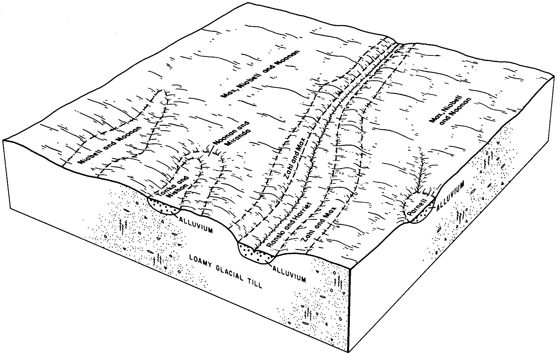
Niobell-Noonan loams, 3 to 6 percent slopes | C661B | 40631 | 2765572 | 2q52b | sd013 | 1987 | 1:20000 |
Williams-Niobell loams, 3 to 6 percent slopes | C667B | 9472 | 2765559 | 2q2jm | sd013 | 1987 | 1:20000 |
Williams-Niobell-Tonka complex, 0 to 6 percent slopes | C147B | 4630 | 2765591 | 2rrpx | sd013 | 1987 | 1:20000 |
Niobell-Noonan loams, 0 to 3 percent slopes | C661A | 662 | 2765580 | 2q77l | sd013 | 1987 | 1:20000 |
Noonan-Niobell-Williams loams, 0 to 6 percent slopes | C665B | 319 | 2797870 | 2q2k9 | sd021 | 1978 | 1:20000 |
Williams-Niobell loams, 0 to 3 percent slopes | C667A | 15 | 2797896 | 2q2jn | sd021 | 1978 | 1:20000 |
Niobell-Noonan loams, 3 to 6 percent slopes | C661B | 8 | 2797893 | 2q52b | sd021 | 1978 | 1:20000 |
Niobell-Noonan loams, 3 to 6 percent slopes | C661B | 66478 | 2798568 | 2q52b | sd045 | 1973 | 1:20000 |
Bowbells-Niobell loams, 0 to 3 percent slopes | C670A | 16625 | 2798602 | 2rrr9 | sd045 | 1973 | 1:20000 |
Max-Niobell-Noonan loams, 3 to 6 percent slopes | C672B | 11313 | 2798672 | 2rrr7 | sd049 | 1981 | 1:20000 |
Niobell-Noonan-Max loams, 0 to 3 percent slopes | C650A | 6817 | 2798669 | 2rrr2 | sd049 | 1981 | 1:20000 |
Niobell-Noonan loams, 0 to 3 percent slopes | C661A | 3386 | 2798646 | 2q77l | sd049 | 1981 | 1:20000 |
Williams-Niobell loams, 3 to 6 percent slopes | C667B | 2896 | 2798622 | 2q2jm | sd049 | 1981 | 1:20000 |
Niobell-Noonan-Max loams, 0 to 3 percent slopes | NbA | 2844 | 355185 | cxll | sd049 | 1981 | 1:20000 |
Niobell-Noonan loams, 3 to 6 percent slopes | C661B | 56 | 2798638 | 2q52b | sd049 | 1981 | 1:20000 |
Bowbells-Niobell loams, 0 to 3 percent slopes | C670A | 13 | 2798673 | 2rrr9 | sd049 | 1981 | 1:20000 |
Niobell-Noonan loams, 3 to 6 percent slopes | C661B | 41399 | 2798724 | 2q52b | sd089 | 1980 | 1:20000 |
Williams-Niobell loams, 0 to 3 percent slopes | C667A | 16563 | 2798693 | 2q2jn | sd089 | 1980 | 1:20000 |
Niobell-Noonan loams, 0 to 3 percent slopes | C661A | 471 | 2798744 | 2q77l | sd089 | 1980 | 1:20000 |
Williams-Niobell loams, 3 to 6 percent slopes | C667B | 131 | 2798692 | 2q2jm | sd089 | 1980 | 1:20000 |
Noonan-Niobell-Williams loams, 0 to 6 percent slopes | C665B | 90 | 2798699 | 2q2k9 | sd089 | 1980 | 1:20000 |
Bowbells-Niobell loams, 0 to 3 percent slopes | C670A | 33 | 2798771 | 2rrr9 | sd089 | 1980 | 1:20000 |
Niobell-Noonan loams, 0 to 3 percent slopes | C661A | 436 | 2799468 | 2q77l | sd107 | 1983 | 1:20000 |
Williams-Niobell loams, 0 to 3 percent slopes | C667A | 10892 | 2799490 | 2q2jn | sd115 | 1997 | 1:24000 |
Williams-Niobell-Tonka complex, 0 to 6 percent slopes | C147B | 7671 | 2799511 | 2rrpx | sd115 | 1997 | 1:24000 |
Niobell-Noonan loams, 0 to 3 percent slopes | C661A | 1975 | 2799505 | 2q77l | sd115 | 1997 | 1:24000 |
Niobell-Noonan-Heil complex, 0 to 3 percent slopes | C668A | 1570 | 2799520 | 2rrr6 | sd115 | 1997 | 1:24000 |
Williams-Niobell loams, 3 to 6 percent slopes | C667B | 881 | 2799489 | 2q2jm | sd115 | 1997 | 1:24000 |
Max-Niobell-Noonan loams, 3 to 6 percent slopes | C672B | 347 | 2799521 | 2rrr7 | sd115 | 1997 | 1:24000 |
Niobell-Noonan-Max loams, 0 to 3 percent slopes | C650A | 273 | 2799519 | 2rrr2 | sd115 | 1997 | 1:24000 |
Niobell-Noonan loams, 0 to 3 percent slopes | C661A | 3765 | 2800111 | 2q77l | sd129 | 1975 | 1:20000 |
Niobell-Noonan loams, 3 to 6 percent slopes | C661B | 1231 | 2800101 | 2q52b | sd129 | 1975 | 1:20000 |
Bowbells-Niobell loams, 0 to 3 percent slopes | C670A | 8 | 2800126 | 2rrr9 | sd129 | 1975 | 1:20000 |