| Nipton-Rock outcrop-Nickel family complex, 10 to 50 percent slopes | 57 | 15461 | 52390 | 1rj0 | az623 | 1994 | 1:24000 |
Nickel-Topawa-Eba families complex, 10 to 50 percent slopes | 84 | 33175 | 1507947 | 1mm4g | az627 | 2005 | 1:24000 |
Tumarion-Nickel family complex, 8 to 35 percent slopes | 136 | 60 | 1507999 | 1mm64 | az627 | 2005 | 1:24000 |
Greyeagle-Continental-Nickel association, 1 to 40 percent slopes | 65 | 34180 | 53115 | 1s8d | az645 | 1982 | 1:24000 |
Eba-Nickel-Cave association, 3 to 25 percent slopes | 39 | 7880 | 53068 | 1s6w | az645 | 1982 | 1:24000 |
Nickel-Cave complex, 8 to 30 percent slopes | 93 | 6340 | 53175 | 1sbb | az645 | 1982 | 1:24000 |
Nickel-Cave complex, low precipitation, 8 to 30 percent slopes | 94 | 4120 | 53182 | 1sbk | az645 | 1982 | 1:24000 |
Tres Hermanos-Continental-Nickel complex, 2 to 45 percent slopes | 43 | 57220 | 54468 | 1tp1 | az663 | 1979 | 1:24000 |
Detrital-Nickel family complex, 1 to 4 percent slopes | 29 | 66538 | 798373 | vsrz | az697 | 2005 | 1:24000 |
Nickel family-Bluebird complex, 15 to 45 percent slopes | 94 | 41877 | 798444 | vsv8 | az697 | 2005 | 1:24000 |
Tumarion-Nickel family complex, 8 to 35 percent slopes | 150 | 30197 | 798491 | vsws | az697 | 2005 | 1:24000 |
Detrital-Nickel complex, dry, 1 to 6 percent slopes | 28 | 26449 | 798374 | vss0 | az697 | 2005 | 1:24000 |
Arizo-Detrital-Nickel complex, 2 to 6 percent slopes | 5 | 21124 | 798356 | vsrf | az697 | 2005 | 1:24000 |
Nickel-Skelon family-Detrital complex, 3 to 10 percent slopes | 95 | 19270 | 798443 | vsv7 | az697 | 2005 | 1:24000 |
Tumarion-Nickel family complex, moist, 5 to 40 percent slopes | 151 | 17356 | 798490 | vswr | az697 | 2005 | 1:24000 |
Nickel-Topawa-Eba families complex, 10 to 50 percent slopes | 96 | 91 | 1398220 | 1hxyw | az697 | 2005 | 1:24000 |
Nickel family extremely gravelly sandy loam, 2 to 35 percent slopes | 28 | 8550 | 54492 | 1tpt | az699 | 1993 | 1:24000 |
Vace-Nickel complex, 4 to 30 percent slope | 705 | 3969 | 2967276 | 2ww2v | ca795 | 2023 | 1:24000 |
Filaree-Lanip-Nickel association | 190 | 102 | 3394056 | hqvq | ca795 | 2023 | 1:24000 |
Nickel gravelly sandy loam, 3 to 9 percent slopes | NC | 128508 | 57040 | 1xc0 | nm023 | 1967 | 1:31680 |
Lehmans-Nickel association, 1 to 9 percent slopes | LN | 42694 | 57030 | 1xbp | nm023 | 1967 | 1:31680 |
Eba-Nickel complex, 10 to 60 percent slopes | EN | 31403 | 57003 | 1x9t | nm023 | 1967 | 1:31680 |
Nickel-Turney association, 0 to 5 percent slopes | NT | 7853 | 57041 | 1xc1 | nm023 | 1967 | 1:31680 |
Nickel gravelly loam, 1 to 5 percent slopes | Ng | 2964 | 57042 | 1xc2 | nm023 | 1967 | 1:31680 |
Nickel very gravelly sandy loam, 3 to 9 percent slopes | NK | 68243 | 56056 | 1wb8 | nm029 | 1967 | 1:24000 |
Nickel-Tres Hermanos complex | NT | 42052 | 56057 | 1wb9 | nm029 | 1967 | 1:24000 |
Nickel-Latene association | NL | 905 | 55670 | 1vxt | nm600 | 1973 | 1:24000 |
Nickel-Latene associatin, rolling | NL | 11050 | 55818 | 1w2l | nm612 | 1970 | 1:24000 |
Nickel-Tencee association, strongly sloping | NTD | 38680 | 635678 | pbgr | nm646 | 1976 | 1:24000 |
Nickel-Aztec gravelly sandy loams, 2 to 8 percent slopes | NaC | 4939 | 635677 | pbgq | nm646 | 1976 | 1:24000 |
Nickel very gravelly fine sandy loam, very steep | 62 | 227215 | 56546 | 1wv2 | nm660 | 1981 | 1:48000 |
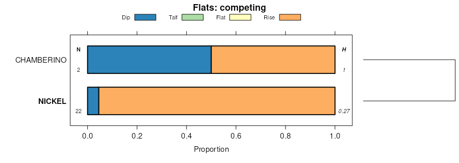
Nickel-Chamberino association, gently sloping | 63 | 76032 | 56547 | 1wv3 | nm660 | 1981 | 1:48000 |
Nickel-Tencee-Delnorte complex, moderately sloping | 64 | 48904 | 56548 | 1wv4 | nm660 | 1981 | 1:48000 |
Badland-Nickel complex, extremely steep | 16 | 18583 | 56491 | 1ws9 | nm660 | 1981 | 1:48000 |
Nickel-Upton association, 2 to 15 percent slopes MLRA 42 | 38 | 58321 | 59306 | 2spss | nm662 | 1979 | 1:48000 |
Continental-Nickel association, 0 to 15 percent slopes | 10 | 10003 | 59276 | 2spsp | nm662 | 1979 | 1:48000 |
Nickel-Caliza very gravelly sandy loams, 1 to 30 percent slopes | 649 | 202540 | 57162 | 1xgy | nm664 | 1984 | 1:24000 |
Nickel variant very gravelly sandy loam, 2 to 15 percent slopes | 638 | 2616 | 57157 | 1xgs | nm664 | 1984 | 1:24000 |
Nickel-Upton association | NU | 78539 | 634578 | p9b8 | nm690 | | 1:24000 |
Nickel-Badland complex | NB | 49554 | 634577 | p9b7 | nm690 | | 1:24000 |
Masonfort-Nickel association | MN | 48893 | 634573 | p9b3 | nm690 | | 1:24000 |
Nickel-Bitter Spring association | NIC | 2469 | 1897517 | 21pj7 | nv608 | 1967 | 1:24000 |
Crosgrain-Irongold-Nickel association | 240 | 21447 | 468844 | hqw0 | nv755 | 2006 | 1:24000 |
Filaree-Lanip-Nickel association | 190 | 16709 | 468835 | hqvq | nv755 | 2006 | 1:24000 |
Nickel-Arizo association | 210 | 9088 | 468839 | hqvv | nv755 | 2006 | 1:24000 |
Bard-Nickel-Limewash association | 270 | 7745 | 468849 | hqw5 | nv755 | 2006 | 1:24000 |
Crosgrain-Typic Torriorthents-Nickel association | 241 | 4853 | 468845 | hqw1 | nv755 | 2006 | 1:24000 |
Nickel-Crosgrain association | 211 | 2961 | 468840 | hqvw | nv755 | 2006 | 1:24000 |
Heleweiser-Upperline-Nickel association | 289 | 1276 | 469037 | hr27 | nv755 | 2006 | 1:24000 |
Canoto-Nickel association | 2058 | 1243 | 469079 | hr3l | nv785 | 1995 | 1:24000 |
Weiser-Nickel association | 2021 | 834 | 469068 | hr37 | nv785 | 1995 | 1:24000 |
Nickel very gravelly fine sandy loam, bedrock substratum, 2 to 8 percent slopes | 440 | 899 | 469316 | hrc7 | nv788 | 1982 | 1:24000 |
Aztec-Nickel-Knob Hill complex, 2 to 15 percent slopes | 418 | 895 | 469313 | hrc4 | nv788 | 1982 | 1:24000 |
Nickel-Crosgrain association | 211 | 432 | 1680992 | 1tf6k | nv788 | 1982 | 1:24000 |
Nickel-Chispa association, undulating | NcC | 26614 | 58481 | 1yvh | tx243 | 1971 | 1:31680 |
Chispa-Nickel association, undulating | CnC | 13683 | 58466 | 1yv0 | tx243 | 1971 | 1:31680 |
Vieja-Nickel association, hilly | VnE | 13358 | 58496 | 1yvz | tx243 | 1971 | 1:31680 |
Canutio-Nickel association, rolling | ClD | 9897 | 58465 | 1ytz | tx243 | 1971 | 1:31680 |