| NewGlarus silt loam, 14 to 18 percent slopes, moderately eroded | 938E2 | 550 | 407575 | fp3l | ia097 | 1988 | 1:15840 |
NewGlarus silt loam, 9 to 14 percent slopes, moderately eroded | 938D2 | 406 | 407573 | fp3j | ia097 | 1988 | 1:15840 |
NewGlarus silt loam, 14 to 18 percent slopes | 938E | 269 | 407574 | fp3k | ia097 | 1988 | 1:15840 |
Whalan and NewGlarus silt loams, 5 to 10 percent slopes, eroded | 561C2 | 66 | 1483212 | 1lsdk | il007 | 2006 | 1:12000 |
Whalan and NewGlarus silt loams, 10 to 15 percent slopes, eroded | 561D2 | 62 | 1483213 | 1lsdl | il007 | 2006 | 1:12000 |
Whalan and NewGlarus silt loams, 2 to 5 percent slopes | 561B | 26 | 199860 | 6pz3 | il007 | 2006 | 1:12000 |
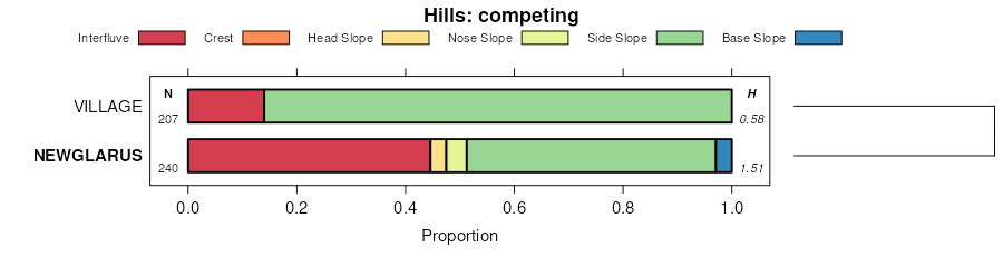
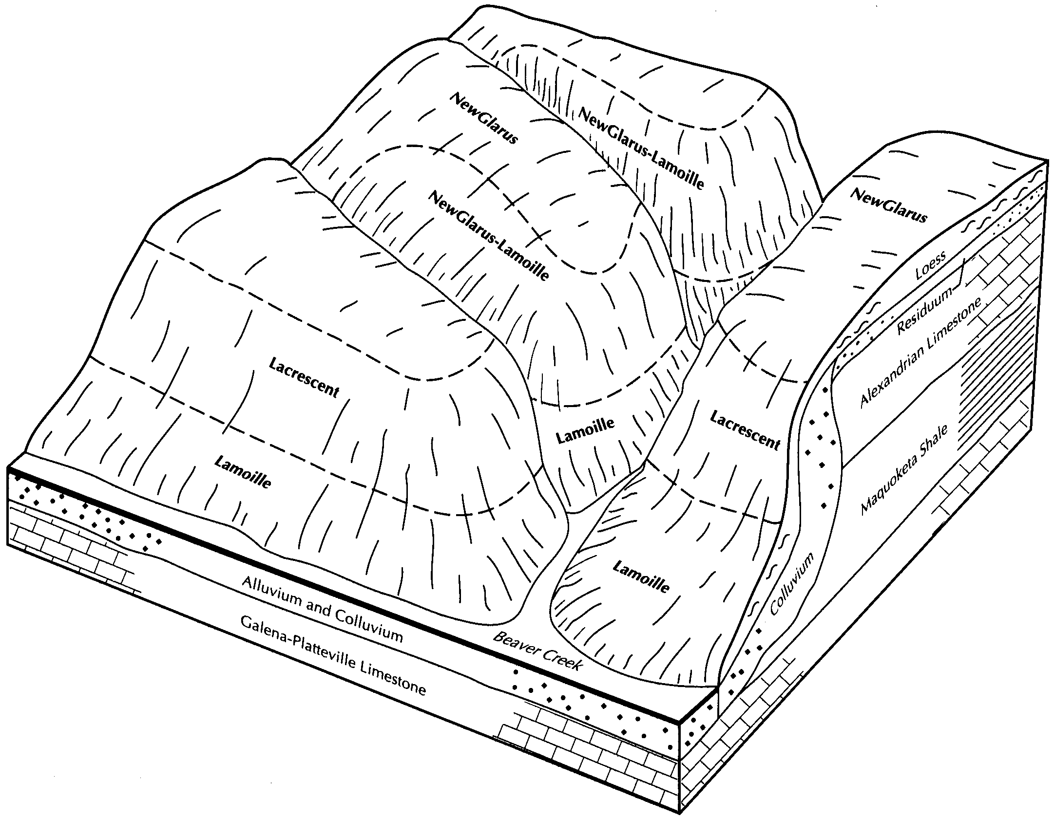
Newglarus-Lamoille silt loams, silurian landscape, 18 to 35 percent slopes | 905F | 5708 | 850720 | 2t7z6 | il015 | 2005 | 1:12000 |
Newglarus-Lamoille silt loams, silurian landscape, 35 to 60 percent slopes | 905G | 2988 | 850714 | 2t7z7 | il015 | 2005 | 1:12000 |
Newglarus-Palsgrove silt loams, silurian landscape, 10 to 18 percent slopes, moderately eroded | 928D2 | 2435 | 1014916 | 2t7z4 | il015 | 2005 | 1:12000 |
Newglarus-Palsgrove silt loams, silurian landscape, 5 to 10 percent slopes, moderately eroded | 928C2 | 608 | 1014917 | 2t7z5 | il015 | 2005 | 1:12000 |
Newglarus-Lamoille silt loams, silurian landscape, 18 to 35 percent slopes | 905F | 14699 | 1949691 | 2t7z6 | il085 | 1990 | 1:12000 |
Newglarus-Palsgrove silt loams, silurian landscape, 10 to 18 percent slopes, moderately eroded | 928D2 | 10877 | 1949693 | 2t7z4 | il085 | 1990 | 1:12000 |
Newglarus-Palsgrove silt loams, silurian landscape, 10 to 18 percent slopes, moderately eroded | 928D2 | 554 | 1675998 | 2t7z4 | il177 | 2006 | 1:12000 |
Newglarus-Lamoille silt loams, silurian landscape, 18 to 35 percent slopes | 905F | 281 | 1675997 | 2t7z6 | il177 | 2006 | 1:12000 |
Whalan and NewGlarus silt loams, 5 to 10 percent slopes, eroded | 561C2 | 2922 | 174127 | 5v60 | il201 | 1997 | 1:12000 |
Whalan and NewGlarus silt loams, 10 to 15 percent slopes, eroded | 561D2 | 2022 | 174128 | 5v61 | il201 | 1997 | 1:12000 |
Whalan and NewGlarus silt loams, 2 to 5 percent slopes | 561B | 485 | 174126 | 5v5z | il201 | 1997 | 1:12000 |
NewGlarus silt loam, 2 to 6 percent slopes | NeB | 4401 | 162442 | 5g12 | in017 | 1979 | 1:15840 |
NewGlarus silt loam, 6 to 12 percent slopes | NeC | 860 | 162443 | 5g13 | in017 | 1979 | 1:15840 |
NewGlarus silt loam, 12 to 20 percent slopes | 501D | 4551 | 429067 | gdgw | mn169 | 1987 | 1:20000 |
NewGlarus silt loam, 6 to 12 percent slopes | 501C | 3426 | 429066 | gdgv | mn169 | 1987 | 1:20000 |
NewGlarus silt loam, rocky, 12 to 30 percent slopes | 501E | 2139 | 429068 | gdgx | mn169 | 1987 | 1:20000 |
NewGlarus silt loam, 3 to 6 percent slopes | 501B | 691 | 429065 | gdgt | mn169 | 1987 | 1:20000 |
Newglarus silt loam, deep, 12 to 20 percent slopes, moderately eroded | 144D2 | 6901 | 2561713 | 2t7zl | wi011 | 1960 | 1:12000 |
Newglarus silt loam, deep, 6 to 12 percent slopes, moderately eroded | 144C2 | 4329 | 2561712 | 2t7zk | wi011 | 1960 | 1:12000 |
Newglarus silt loam, deep, 20 to 30 percent slopes, moderately eroded | 144E2 | 4303 | 2561714 | 2t7zm | wi011 | 1960 | 1:12000 |
Newglarus silt loam, deep, 2 to 6 percent slopes, moderately eroded | 144B2 | 1733 | 2561711 | 2t7zj | wi011 | 1960 | 1:12000 |
Newglarus silt loam, deep, 12 to 20 percent slopes, moderately eroded | 144D2 | 12836 | 2503843 | 2t7zl | wi023 | 1960 | 1:12000 |
Newglarus silt loam, deep, 6 to 12 percent slopes, moderately eroded | 144C2 | 894 | 2503838 | 2t7zk | wi023 | 1960 | 1:12000 |
Newglarus silt loam, deep, 2 to 6 percent slopes, moderately eroded | 144B2 | 46 | 2503833 | 2t7zj | wi023 | 1960 | 1:12000 |
Newglarus-Dunbarton silt loams, 12 to 20 percent slopes, moderately eroded | 1180D2 | 10537 | 2629035 | 2t7yz | wi025 | 1972 | 1:15840 |
Newglarus-Dunbarton silt loams, 6 to 12 percent slopes, moderately eroded | 1180C2 | 8977 | 2629037 | 2t7yy | wi025 | 1972 | 1:15840 |
Newglarus silt loam, moderately deep, 6 to 12 percent slopes, moderately eroded | 194C2 | 5849 | 753546 | 2t7xm | wi025 | 1972 | 1:15840 |
Newglarus silt loam, moderately deep, 12 to 20 percent slopes, moderately eroded | 194D2 | 2491 | 753547 | 2t7xq | wi025 | 1972 | 1:15840 |
Newglarus silt loam, moderately deep, 2 to 6 percent slopes, moderately eroded | 194B2 | 2198 | 753545 | 2t7xw | wi025 | 1972 | 1:15840 |
Newglarus-Dunbarton, very stony, silt loams, 20 to 30 percent slopes, very rocky | 1180E | 1499 | 2629039 | 2t7z0 | wi025 | 1972 | 1:15840 |
Newglarus-Dunbarton silt loams, 2 to 6 percent slopes, moderately eroded | 1180B2 | 880 | 2629036 | 2t7yx | wi025 | 1972 | 1:15840 |
Newglarus silt loam, moderately deep, 20 to 30 percent slopes, moderately eroded | 194E2 | 537 | 753548 | 2t7xv | wi025 | 1972 | 1:15840 |
Newglarus-Dunbarton, very stony, silt loams, 30 to 60 percent slopes, very rocky | 1180F | 91 | 2629038 | 2t7z1 | wi025 | 1972 | 1:15840 |
Newglarus silt loam, deep, 6 to 12 percent slopes, moderately eroded | 144C2 | 2458 | 2503839 | 2t7zk | wi033 | 2003 | 1:12000 |
Newglarus silt loam, deep, 12 to 20 percent slopes, moderately eroded | 144D2 | 2289 | 2503844 | 2t7zl | wi033 | 2003 | 1:12000 |
Newglarus silt loam, deep, 2 to 6 percent slopes, moderately eroded | 144B2 | 897 | 2503834 | 2t7zj | wi033 | 2003 | 1:12000 |
Newglarus silt loam, deep, 20 to 30 percent slopes, moderately eroded | 144E2 | 535 | 2503849 | 2t7zm | wi033 | 2003 | 1:12000 |
Newglarus silt loam, moderately deep, 20 to 30 percent slopes, moderately eroded | 194E2 | 36027 | 424183 | 2t7xv | wi043 | 1959 | 1:20000 |
Newglarus silt loam, moderately deep, 12 to 20 percent slopes, moderately eroded | 194D2 | 33374 | 424181 | 2t7xq | wi043 | 1959 | 1:20000 |
Newglarus complex, 12 to 20 percent slopes, moderately eroded | 1194D2 | 17250 | 1454353 | 2t7z3 | wi043 | 1959 | 1:20000 |
Newglarus silt loam, moderately deep, 6 to 12 percent slopes, moderately eroded | 194C2 | 9641 | 424177 | 2t7xm | wi043 | 1959 | 1:20000 |
Newglarus-Dunbarton, very stony, silt loams, 20 to 30 percent slopes, very rocky | 1180E | 4962 | 424210 | 2t7z0 | wi043 | 1959 | 1:20000 |
Newglarus-Dunbarton silt loams, 12 to 20 percent slopes, moderately eroded | 1180D2 | 2749 | 424208 | 2t7yz | wi043 | 1959 | 1:20000 |
Newglarus complex, 6 to 12 percent slopes, moderately eroded | 1194C2 | 1976 | 1454345 | 2t7z2 | wi043 | 1959 | 1:20000 |
Newglarus-Dunbarton, very stony, silt loams, 30 to 60 percent slopes, very rocky | 1180F | 173 | 424211 | 2t7z1 | wi043 | 1959 | 1:20000 |
Newglarus-Dunbarton silt loams, 6 to 12 percent slopes, moderately eroded | 1180C2 | 108 | 424207 | 2t7yy | wi043 | 1959 | 1:20000 |
Newglarus silt loam, moderately deep, 2 to 6 percent slopes, moderately eroded | 194B2 | 105 | 424175 | 2t7xw | wi043 | 1959 | 1:20000 |
Newglarus silt loam, moderately deep, 12 to 20 percent slopes, moderately eroded | 194D2 | 27522 | 425321 | 2t7xq | wi045 | 1969 | 1:12000 |
Newglarus silt loam, moderately deep, 6 to 12 percent slopes, moderately eroded | 194C2 | 23376 | 425320 | 2t7xm | wi045 | 1969 | 1:12000 |
Newglarus-Dunbarton silt loams, 12 to 20 percent slopes, moderately eroded | 1180D2 | 9576 | 2629032 | 2t7yz | wi045 | 1969 | 1:12000 |
Newglarus-Dunbarton silt loams, 6 to 12 percent slopes, moderately eroded | 1180C2 | 8910 | 2629031 | 2t7yy | wi045 | 1969 | 1:12000 |
Newglarus silt loam, moderately deep, 2 to 6 percent slopes, moderately eroded | 194B2 | 3184 | 425319 | 2t7xw | wi045 | 1969 | 1:12000 |
Newglarus complex, 12 to 20 percent slopes, moderately eroded | 1194D2 | 2738 | 1591198 | 2t7z3 | wi045 | 1969 | 1:12000 |
Newglarus silt loam, moderately deep, 20 to 30 percent slopes, moderately eroded | 194E2 | 1920 | 425322 | 2t7xv | wi045 | 1969 | 1:12000 |
Newglarus-Dunbarton, very stony, silt loams, 20 to 30 percent slopes, very rocky | 1180E | 1115 | 2629033 | 2t7z0 | wi045 | 1969 | 1:12000 |
Newglarus-Dunbarton silt loams, 2 to 6 percent slopes, moderately eroded | 1180B2 | 844 | 2629030 | 2t7yx | wi045 | 1969 | 1:12000 |
Newglarus complex, 6 to 12 percent slopes, moderately eroded | 1194C2 | 606 | 1591197 | 2t7z2 | wi045 | 1969 | 1:12000 |
Newglarus-Dunbarton, very stony, silt loams, 30 to 60 percent slopes, very rocky | 1180F | 109 | 2629034 | 2t7z1 | wi045 | 1969 | 1:12000 |
Newglarus silt loam, moderately deep, 12 to 20 percent slopes, moderately eroded | 194D2 | 41091 | 424563 | 2t7xq | wi049 | 1960 | 1:20000 |
Newglarus silt loam, moderately deep, 6 to 12 percent slopes, moderately eroded | 194C2 | 21830 | 424561 | 2t7xm | wi049 | 1960 | 1:20000 |
Newglarus silt loam, deep, 12 to 20 percent slopes, moderately eroded | 144D2 | 18159 | 2774777 | 2t7zl | wi049 | 1960 | 1:20000 |
Newglarus silt loam, moderately deep, 20 to 30 percent slopes, moderately eroded | 194E2 | 4869 | 424565 | 2t7xv | wi049 | 1960 | 1:20000 |
Newglarus silt loam, deep, 6 to 12 percent slopes, moderately eroded | 144C2 | 3800 | 2774776 | 2t7zk | wi049 | 1960 | 1:20000 |
Newglarus silt loam, moderately deep, 2 to 6 percent slopes, moderately eroded | 194B2 | 3585 | 424559 | 2t7xw | wi049 | 1960 | 1:20000 |
Newglarus-Dunbarton, very stony, silt loams, 20 to 30 percent slopes, very rocky | 1180E | 2260 | 424587 | 2t7z0 | wi049 | 1960 | 1:20000 |
Newglarus-Dunbarton silt loams, 12 to 20 percent slopes, moderately eroded | 1180D2 | 2002 | 424585 | 2t7yz | wi049 | 1960 | 1:20000 |
Newglarus complex, 6 to 12 percent slopes, moderately eroded | 1194C2 | 743 | 1454911 | 2t7z2 | wi049 | 1960 | 1:20000 |
Newglarus-Dunbarton, very stony, silt loams, 30 to 60 percent slopes, very rocky | 1180F | 335 | 2806662 | 2t7z1 | wi049 | 1960 | 1:20000 |
Newglarus-Dunbarton silt loams, 6 to 12 percent slopes, moderately eroded | 1180C2 | 277 | 424583 | 2t7yy | wi049 | 1960 | 1:20000 |
Newglarus complex, 12 to 20 percent slopes, moderately eroded | 1194D2 | 201 | 1454925 | 2t7z3 | wi049 | 1960 | 1:20000 |
Newglarus silt loam, deep, 2 to 6 percent slopes, moderately eroded | 144B2 | 134 | 2774775 | 2t7zj | wi049 | 1960 | 1:20000 |
Newglarus silt loam, deep, 2 to 6 percent slopes, moderately eroded | 144B2 | 748 | 2561441 | 2t7zj | wi057 | 1987 | 1:12000 |
Newglarus silt loam, deep, 6 to 12 percent slopes, moderately eroded | 144C2 | 309 | 2561442 | 2t7zk | wi057 | 1987 | 1:12000 |
Newglarus silt loam, moderately deep, 12 to 20 percent slopes, moderately eroded | 194D2 | 46884 | 424777 | 2t7xq | wi065 | 1964 | 1:15840 |
Newglarus silt loam, moderately deep, 6 to 12 percent slopes, moderately eroded | 194C2 | 28001 | 424775 | 2t7xm | wi065 | 1964 | 1:15840 |
Newglarus silt loam, moderately deep, 20 to 30 percent slopes, moderately eroded | 194E2 | 5697 | 424779 | 2t7xv | wi065 | 1964 | 1:15840 |
Newglarus complex, 12 to 20 percent slopes, moderately eroded | 1194D2 | 3154 | 1454721 | 2t7z3 | wi065 | 1964 | 1:15840 |
Newglarus-Dunbarton silt loams, 12 to 20 percent slopes, moderately eroded | 1180D2 | 2346 | 2561802 | 2t7yz | wi065 | 1964 | 1:15840 |
Newglarus-Dunbarton, very stony, silt loams, 30 to 60 percent slopes, very rocky | 1180F | 2283 | 2561805 | 2t7z1 | wi065 | 1964 | 1:15840 |
Newglarus silt loam, moderately deep, 2 to 6 percent slopes, moderately eroded | 194B2 | 2001 | 424773 | 2t7xw | wi065 | 1964 | 1:15840 |
Newglarus-Dunbarton, very stony, silt loams, 20 to 30 percent slopes, very rocky | 1180E | 1945 | 2561806 | 2t7z0 | wi065 | 1964 | 1:15840 |
Newglarus complex, 6 to 12 percent slopes, moderately eroded | 1194C2 | 1587 | 1454720 | 2t7z2 | wi065 | 1964 | 1:15840 |
Newglarus-Dunbarton silt loams, 6 to 12 percent slopes, moderately eroded | 1180C2 | 812 | 2561804 | 2t7yy | wi065 | 1964 | 1:15840 |
Newglarus-Dunbarton silt loams, 2 to 6 percent slopes, moderately eroded | 1180B2 | 59 | 2561803 | 2t7yx | wi065 | 1964 | 1:15840 |
Newglarus silt loam, deep, 12 to 20 percent slopes, moderately eroded | 144D2 | 122 | 2685191 | 2t7zl | wi081 | 1981 | 1:12000 |
Newglarus silt loam, deep, 6 to 12 percent slopes, moderately eroded | 144C2 | 41 | 2685190 | 2t7zk | wi081 | 1981 | 1:12000 |
Newglarus silt loam, deep, 2 to 6 percent slopes, moderately eroded | 144B2 | 1 | 2685203 | 2t7zj | wi081 | 1981 | 1:12000 |
Newglarus silt loam, deep, 12 to 20 percent slopes, moderately eroded | 144D2 | 1839 | 2503845 | 2t7zl | wi091 | 1998 | 1:12000 |
Newglarus silt loam, deep, 6 to 12 percent slopes, moderately eroded | 144C2 | 1182 | 2503840 | 2t7zk | wi091 | 1998 | 1:12000 |
Newglarus silt loam, deep, 20 to 30 percent slopes, moderately eroded | 144E2 | 585 | 2503850 | 2t7zm | wi091 | 1998 | 1:12000 |
Newglarus silt loam, deep, 2 to 6 percent slopes, moderately eroded | 144B2 | 156 | 2503835 | 2t7zj | wi091 | 1998 | 1:12000 |
Newglarus silt loam, deep, 20 to 30 percent slopes, moderately eroded | 144E2 | 4776 | 1690937 | 2t7zm | wi093 | 2006 | 1:12000 |
Newglarus silt loam, deep, 12 to 20 percent slopes, moderately eroded | 144D2 | 4398 | 1690935 | 2t7zl | wi093 | 2006 | 1:12000 |
Newglarus silt loam, deep, 6 to 12 percent slopes, moderately eroded | 144C2 | 389 | 1690934 | 2t7zk | wi093 | 2006 | 1:12000 |
Newglarus silt loam, deep, 2 to 6 percent slopes, moderately eroded | 144B2 | 113 | 1690933 | 2t7zj | wi093 | 2006 | 1:12000 |
Newglarus silt loam, deep, 6 to 12 percent slopes, moderately eroded | 144C2 | 8481 | 2503841 | 2t7zk | wi103 | 2002 | 1:12000 |
Newglarus silt loam, deep, 12 to 20 percent slopes, moderately eroded | 144D2 | 4037 | 2503846 | 2t7zl | wi103 | 2002 | 1:12000 |
Newglarus silt loam, deep, 2 to 6 percent slopes, moderately eroded | 144B2 | 407 | 2503836 | 2t7zj | wi103 | 2002 | 1:12000 |
Newglarus silt loam, deep, 12 to 20 percent slopes, moderately eroded | 144D2 | 2140 | 2683439 | 2t7zl | wi121 | 1969 | 1:12000 |
Newglarus silt loam, deep, 6 to 12 percent slopes, moderately eroded | 144C2 | 1708 | 2683438 | 2t7zk | wi121 | 1969 | 1:12000 |
Newglarus silt loam, deep, 20 to 30 percent slopes, moderately eroded | 144E2 | 808 | 2683440 | 2t7zm | wi121 | 1969 | 1:12000 |
Newglarus silt loam, deep, 2 to 6 percent slopes, moderately eroded | 144B2 | 259 | 2683437 | 2t7zj | wi121 | 1969 | 1:12000 |
Newglarus silt loam, deep, 12 to 20 percent slopes, moderately eroded | 144D2 | 24505 | 2503847 | 2t7zl | wi123 | 1965 | 1:12000 |
Newglarus silt loam, deep, 6 to 12 percent slopes, moderately eroded | 144C2 | 11396 | 2503842 | 2t7zk | wi123 | 1965 | 1:12000 |
Newglarus silt loam, deep, 2 to 6 percent slopes, moderately eroded | 144B2 | 1602 | 2503837 | 2t7zj | wi123 | 1965 | 1:12000 |