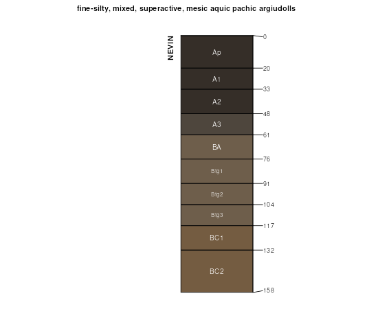
| Nevin silty clay loam, 0 to 2 percent slopes, rarely flooded | 88 | 1078 | 1404887 | 2xbmm | ia003 | 2008 | 1:12000 |
Nevin silty clay loam, sandy substratum, 0 to 2 percent slopes | 1088 | 3726 | 402807 | fj4s | ia011 | 1977 | 1:15840 |
Nevin silty clay loam, 0 to 2 percent slopes | 88 | 3970 | 413201 | fvz2 | ia013 | 2001 | 1:12000 |
Nevin-Urban land complex, 0 to 2 percent slopes | 4088 | 304 | 449419 | h2nd | ia013 | 2001 | 1:12000 |
Nevin silty clay loam, 0 to 2 percent slopes | 88 | 1092 | 403447 | fjtf | ia023 | 1978 | 1:15840 |
Nevin silty clay loam, 0 to 2 percent slopes, rarely flooded | 88 | 2788 | 1868003 | 2xbmm | ia029 | 2010 | 1:12000 |
Nevin silty clay loam, 0 to 2 percent slopes, rarely flooded | 88 | 546 | 1397141 | 1hwv2 | ia031 | 2008 | 1:12000 |
Nevin silty clay loam, 0 to 2 percent slopes | 88 | 2668 | 404467 | fkwb | ia045 | 1978 | 1:15840 |
Nevin silty clay loam, 0 to 2 percent slopes, rarely flooded | 88 | 1209 | 404633 | 2xbmm | ia049 | 1980 | 1:15840 |
Nevin silty clay loam, heavy till, 0 to 2 percent slopes, rarely flooded | 88 | 533 | 404851 | 2wbdl | ia053 | 1986 | 1:15840 |
Nevin slilt clay loam, 0 to 2 percent slopes | 88 | 52 | 2479284 | 2p6wx | ia067 | 1989 | 1:15840 |
Nevin silty clay loam, 0 to 2 percent slopes, rarely flooded | 88 | 2557 | 406169 | 2xbmm | ia071 | 1968 | 1:20000 |
Nevin silty clay loam, 0 to 2 percent slopes | 88 | 1941 | 406325 | fmt8 | ia075 | 1973 | 1:15840 |
Nevin silty clay loam, 0 to 2 percent slopes, rarely flooded | 88 | 1629 | 406432 | 2xbmm | ia077 | 1968 | 1:15840 |
Nevin silty clay loam, 0 to 2 percent slopes | 88 | 277 | 406910 | fnf4 | ia087 | 1982 | 1:15840 |
Nevin silty clay loam, heavy till, 0 to 2 percent slopes, rarely flooded | S88 | 121 | 3004654 | 2wbdl | ia087 | 1982 | 1:15840 |
Nevin silty clay loam, 0 to 2 percent slopes, rarely flooded | 88 | 4976 | 452982 | h6cb | ia095 | 2005 | 1:12000 |
Nevin silty clay loam, 0 to 2 percent slopes | 88 | 6046 | 407700 | fp7m | ia099 | 1975 | 1:15840 |
Nevin silty clay loam, 0 to 2 percent slopes | 88 | 1647 | 408065 | fpmd | ia103 | 1979 | 1:15840 |
Nevin silty clay loam | 88 | 795 | 408689 | fq8j | ia113 | 1970 | 1:15840 |
Nevin silty clay loam, 0 to 2 percent slopes, rarely flooded | 88 | 1337 | 409231 | 2xbmm | ia121 | 1968 | 1:15840 |
Nevin silty clay loam, 2 to 5 percent slopes, rarely flooded | 88B | 373 | 409232 | 2xbmn | ia121 | 1968 | 1:15840 |
Nevin silty clay loam, 0 to 2 percent slopes | 88 | 568 | 409384 | fqzy | ia123 | 1971 | 1:15840 |
Nevin silty clay loam, 0 to 2 percent slopes | 88 | 1647 | 412810 | fvkg | ia125 | 1976 | 1:15840 |
Nevin silty clay loam, 0 to 2 percent slopes, rarely flooded | Y88 | 806 | 3046430 | 2xbmm | ia125 | 1976 | 1:15840 |
Nevin silty clay loam, heavy till, 0 to 2 percent slopes, rarely flooded | S88 | 244 | 3004655 | 2wbdl | ia125 | 1976 | 1:15840 |
Nevin silty clay loam, 1 to 3 percent slopes | 88 | 1460 | 409510 | fr40 | ia127 | 1978 | 1:15840 |
Nevin silty clay loam, 0 to 2 percent slopes, rarely flooded | 88 | 1740 | 409595 | 2xbmm | ia129 | 1979 | 1:15840 |
Nevin silty clay loam, 0 to 2 percent slopes, rarely flooded | 88 | 695 | 409890 | 2xbmm | ia137 | 1987 | 1:15840 |
Nevin silty clay loam, 0 to 2 percent slopes, rarely flooded | 88 | 2734 | 410232 | 2xbmm | ia145 | 1975 | 1:20000 |
Nevin silty clay loam, 0 to 2 percent slopes, rarely flooded | Y88 | 772 | 3046432 | 2xbmm | ia153 | 1993 | 1:12000 |
Nevin silty clay loam, 0 to 2 percent slopes | 88 | 607 | 412985 | fvr3 | ia153 | 1993 | 1:12000 |
Nevin silty clay loam, 0 to 2 percent slopes, rarely flooded | 88 | 1196 | 410516 | 2xbmm | ia155 | 1986 | 1:15840 |
Nevin silty clay loam, 0 to 2 percent slopes | 88 | 1206 | 410636 | fs9b | ia157 | 1978 | 1:15840 |
Nevin silty clay loam, heavy till, 0 to 2 percent slopes, rarely flooded | S88 | 226 | 3004656 | 2wbdl | ia159 | 1987 | 1:15840 |
Nevin silty clay loam, 0 to 2 percent slopes, rarely flooded | 88 | 220 | 410746 | 2xbmm | ia159 | 1987 | 1:15840 |
Nevin silty clay loam, 0 to 2 percent slopes | 88 | 13058 | 411565 | ft89 | ia171 | 1989 | 1:15840 |
Nevin silty clay loam, 0 to 2 percent slopes, rarely flooded | 88 | 569 | 411660 | 2xbmm | ia173 | 1989 | 1:15840 |
Nevin silty clay loam, heavy till, 0 to 2 percent slopes, rarely flooded | S88 | 1617 | 3004657 | 2wbdl | ia179 | 1978 | 1:15840 |
Nevin silty clay loam, 0 to 2 percent slopes | 88 | 471 | 411862 | ftkw | ia179 | 1978 | 1:15840 |
Nevin silty clay loam, 0 to 2 percent slopes, rarely flooded | 88 | 3057 | 411975 | 2xbmm | ia181 | 1975 | 1:15840 |
Nevin silty clay loam, 2 to 5 percent slopes, rarely flooded | 88B | 467 | 411976 | 2xbmn | ia181 | 1975 | 1:15840 |
Nevin silty clay loam, 0 to 2 percent slopes | 88 | 2038 | 412115 | ftv1 | ia183 | 1983 | 1:15840 |
Nevin silt loam, 0 to 2 percent slopes, rarely flooded | 36028 | 656 | 2532146 | 2qnvv | mo025 | 1967 | 1:24000 |
Nevin silt loam, 1 to 3 percent slopes, rarely flooded | 36086 | 125 | 2544565 | 2qs29 | mo025 | 1967 | 1:24000 |
Nevin silt loam, 0 to 2 percent slopes, rarely flooded | 36028 | 2685 | 2532147 | 2qnvv | mo049 | 1981 | 1:24000 |
Nevin silt loam, 1 to 3 percent slopes, rarely flooded | 36086 | 13 | 2544566 | 2qs29 | mo049 | 1981 | 1:24000 |
Nevin silt loam, 0 to 2 percent slopes, rarely flooded | 36028 | 4644 | 2532145 | 2qnvv | mo075 | 1982 | 1:24000 |
Nevin silt loam, 1 to 3 percent slopes, rarely flooded | 36086 | 66 | 2544567 | 2qs29 | mo075 | 1982 | 1:24000 |
Nevin silty clay loam, 0 to 2 percent slopes | 12504 | 5944 | 887662 | ysp8 | mo147 | 1983 | 1:24000 |
Nevin-Urban land complex, 0 to 2 percent slopes | 66047 | 6870 | 991523 | 128rm | mo189 | 1979 | 1:24000 |
Nevin silt loam, 0 to 2 percent slopes | 66046 | 344 | 991501 | 128qx | mo189 | 1979 | 1:24000 |
Nevin silty clay loam, 0 to 2 percent slopes, rarely flooded | 36027 | 186 | 984569 | 2xbmm | mo227 | 1965 | 1:24000 |
