| Farmington-Nellis complex, 3 to 15 percent slopes, very rocky | 94C | 4607 | 3395857 | 9ls1 | ct601 | 2003 | 1:12000 |
Farmington-Nellis complex, 15 to 35 percent slopes, very rocky | 94E | 2236 | 3395858 | 9ls2 | ct601 | 2003 | 1:12000 |
Nellis fine sandy loam, 3 to 8 percent slopes | 92B | 1522 | 3395854 | 9lry | ct601 | 2003 | 1:12000 |
Nellis fine sandy loam, 8 to 15 percent slopes | 92C | 568 | 3395855 | 9lrz | ct601 | 2003 | 1:12000 |
Nellis fine sandy loam, 3 to 15 percent slopes, very stony | 93C | 478 | 3395856 | 9ls0 | ct601 | 2003 | 1:12000 |
Nellis fine sandy loam, 15 to 25 percent slopes | 92D | 66 | 3395894 | 9lt8 | ct601 | 2003 | 1:12000 |
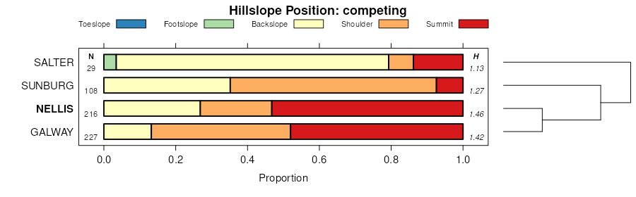
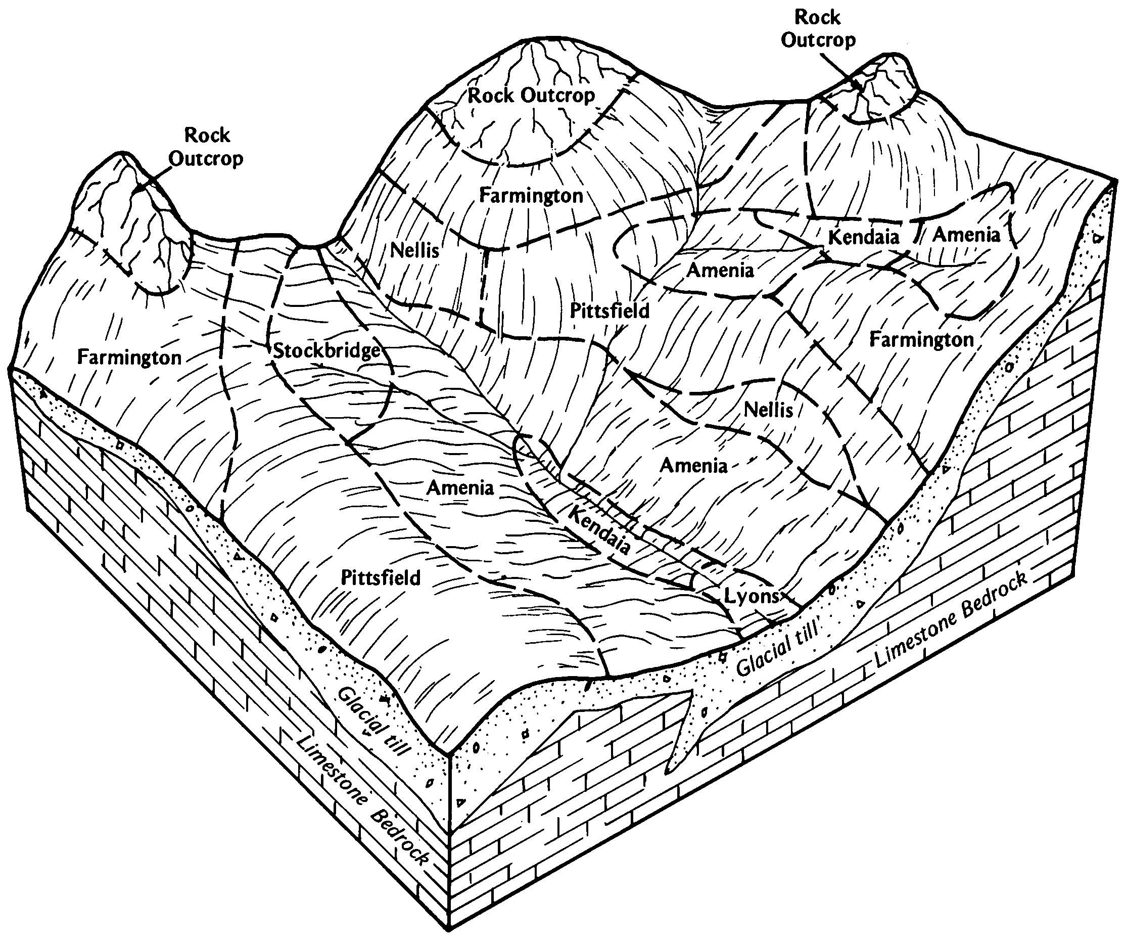
Pittsfield and Nellis loams, 25 to 35 percent slopes, extremely stony | 514E | 3823 | 276644 | 98w0 | ma003 | 1984 | 1:25000 |
Nellis loam, 8 to 15 percent slopes | 505C | 2237 | 276619 | 98v6 | ma003 | 1984 | 1:25000 |
Nellis loam, 3 to 8 percent slopes | 505B | 1354 | 276618 | 98v5 | ma003 | 1984 | 1:25000 |
Nellis loam, 15 to 25 percent slopes, very stony | 506D | 1079 | 276623 | 98vb | ma003 | 1984 | 1:25000 |
Nellis loam, 15 to 25 percent slopes | 505D | 787 | 276620 | 98v7 | ma003 | 1984 | 1:25000 |
Nellis loam, 8 to 15 percent slopes, very stony | 506C | 786 | 276622 | 98v9 | ma003 | 1984 | 1:25000 |
Nellis loam, 3 to 8 percent slopes, very stony | 506B | 781 | 276621 | 98v8 | ma003 | 1984 | 1:25000 |
Nellis loam, 15 to 25 percent slopes, extremely stony | 507D | 542 | 276625 | 98vd | ma003 | 1984 | 1:25000 |
Nellis loam, 8 to 15 percent slopes, extremely stony | 507C | 360 | 276624 | 98vc | ma003 | 1984 | 1:25000 |
Wassaic-Nellis silt loam, rolling, very rocky | WnC | 13 | 288815 | 9pjm | ny001 | 1985 | 1:15840 |
Nellis loam, 8 to 15 percent slopes | NeC | 1083 | 319237 | 2wrdy | ny031 | 2007 | 1:24000 |
Nellis loam, 3 to 8 percent slopes | NeB | 765 | 319238 | 2wrdv | ny031 | 2007 | 1:24000 |
Nellis loam, 15 to 25 percent slopes | NeD | 679 | 319239 | 2wrf1 | ny031 | 2007 | 1:24000 |
Nellis loam, 3 to 8 percent slopes | NlB | 4810 | 291888 | 2wrdv | ny045 | 1981 | 1:15840 |
Nellis loam, 8 to 15 percent slopes | NlC | 3313 | 291889 | 2wrdy | ny045 | 1981 | 1:15840 |
Nellis and Madrid soils, 25 to 50 percent slopes | NmE | 2896 | 291891 | 2wrf4 | ny045 | 1981 | 1:15840 |
Nellis loam, 15 to 25 percent slopes | NlD | 1030 | 291890 | 2wrf1 | ny045 | 1981 | 1:15840 |
Nellis loam, 0 to 3 percent slopes | NlA | 456 | 291887 | 2wrdt | ny045 | 1981 | 1:15840 |
Nellis loam, 2 to 8 percent slopes | NeB | 10143 | 2677752 | bmmm | ny049 | 2018 | 1:24000 |
Nellis loam, 8 to 15 percent slopes | NeC | 3578 | 2677753 | bmmn | ny049 | 2018 | 1:24000 |
Nellis loam, 25 to 35 percent slopes | NaE | 320 | 2677745 | bmmd | ny049 | 2018 | 1:24000 |
Nellis loam, 3 to 15 percent slopes, very stony | NgC | 154 | 2677756 | bmmr | ny049 | 2018 | 1:24000 |
Nellis loam, 15 to 35 percent slopes, very stony | NgD | 57 | 2677757 | bmms | ny049 | 2018 | 1:24000 |
Nellis loam, 3 to 8 percent slopes | NeB | 1214 | 292863 | 2wrdv | ny057 | 1973 | 1:24000 |
Nellis loam, 8 to 15 percent slopes | NeC | 773 | 292864 | 2wrdy | ny057 | 1973 | 1:24000 |
Nellis loam, 15 to 25 percent slopes | NeD | 301 | 292865 | 2wrf1 | ny057 | 1973 | 1:24000 |
Nellis loam, 3 to 8 percent slopes | 176B | 4246 | 293361 | 2wrdv | ny065 | 1993 | 1:24000 |
Nellis loam, 8 to 15 percent slopes | 176C | 1993 | 293362 | 2wrdy | ny065 | 1993 | 1:24000 |
Nellis loam, 15 to 25 percent slopes | 176D | 1280 | 293363 | 2wrf1 | ny065 | 1993 | 1:24000 |
Nellis loam, 3 to 8 percent slopes | NeB | 3803 | 281292 | 2wrdv | vt001 | 1967 | 1:15840 |
Nellis loam, 3 to 15 percent slopes, extremely stony | NsC | 3553 | 281295 | 2wrf5 | vt001 | 1967 | 1:15840 |
Nellis loam, 8 to 15 percent slopes | NeC | 2272 | 281293 | 2wrdy | vt001 | 1967 | 1:15840 |
Nellis loam, 15 to 50 percent slopes, extremely stony | NsD | 1704 | 281296 | 2wrf7 | vt001 | 1967 | 1:15840 |
Nellis loam, 15 to 25 percent slopes | NeD | 832 | 281294 | 2wrf1 | vt001 | 1967 | 1:15840 |
Farmington-Nellis complex, 5 to 12 percent slopes, rocky | FnB | 812 | 281264 | 2wrdx | vt001 | 1967 | 1:15840 |
Farmington-Nellis complex, 12 to 20 percent slopes, rocky | FnC | 425 | 281265 | 2wrf0 | vt001 | 1967 | 1:15840 |
Farmington-Nellis complex, 20 to 30 percent slopes, rocky | FnD | 242 | 281266 | 2wrf3 | vt001 | 1967 | 1:15840 |
Galway-Nellis-Farmington complex, 15 to 25 percent slopes, rocky | 40D | 3470 | 281482 | 2wrfn | vt003 | 1992 | 1:20000 |
Nellis silt loam, 15 to 25 percent slopes, very stony | 85D | 2943 | 281593 | 2wrfj | vt003 | 1992 | 1:20000 |
Nellis silt loam, 8 to 15 percent slopes | 84C | 2288 | 281588 | 2wrfc | vt003 | 1992 | 1:20000 |
Galway-Nellis-Farmington complex, 8 to 15 percent slopes, rocky | 40C | 1918 | 281481 | 2wrfm | vt003 | 1992 | 1:20000 |
Nellis silt loam, 3 to 8 percent slopes | 84B | 1649 | 281587 | 2wrfb | vt003 | 1992 | 1:20000 |
Nellis silt loam, 25 to 50 percent slopes, very stony | 85E | 1512 | 281594 | 2wrfk | vt003 | 1992 | 1:20000 |
Nellis silt loam, 8 to 15 percent slopes, very stony | 85C | 1248 | 281592 | 2wrfh | vt003 | 1992 | 1:20000 |
Nellis silt loam, 15 to 25 percent slopes | 84D | 1072 | 281589 | 2wrfd | vt003 | 1992 | 1:20000 |
Nellis silt loam, 3 to 8 percent slopes, very stony | 85B | 326 | 281591 | 2wrfg | vt003 | 1992 | 1:20000 |
Galway-Nellis-Farmington complex, 3 to 8 percent slopes, rocky | 40B | 316 | 281480 | 2wrfl | vt003 | 1992 | 1:20000 |
Stockbridge and Nellis soils, 3 to 8 percent slopes, stony | SuB | 2325 | 281755 | 2wrdw | vt007 | 1969 | 1:15840 |
Stockbridge and Nellis soils, 8 to 15 percent slopes, stony | SuC | 1255 | 281756 | 2wrdz | vt007 | 1969 | 1:15840 |
Stockbridge and Nellis soils, 3 to 15 percent slopes, extremely stony | SxC | 1013 | 281758 | 2wrf6 | vt007 | 1969 | 1:15840 |
Stockbridge and Nellis soils, 15 to 60 percent slopes, extremely stony | SxE | 843 | 281759 | 2wrf8 | vt007 | 1969 | 1:15840 |
Stockbridge and Nellis soils, 15 to 25 percent slopes, stony | SuD | 458 | 281757 | 2wrf2 | vt007 | 1969 | 1:15840 |
Nellis silt loam, 3 to 8 percent slopes | NaB | 1145 | 279266 | 2wrfb | vt013 | 1956 | 1:20000 |
Nellis silt loam, 8 to 15 percent slopes | NaC | 262 | 279267 | 2wrfc | vt013 | 1956 | 1:20000 |
Nellis silt loam, 3 to 8 percent slopes, very stony | NbB | 187 | 279270 | 2wrfg | vt013 | 1956 | 1:20000 |
Nellis silt loam, 0 to 3 percent slopes | NaA | 99 | 279265 | 2wrf9 | vt013 | 1956 | 1:20000 |
Nellis silt loam, 8 to 15 percent slopes, very stony | NbC | 79 | 279271 | 2wrfh | vt013 | 1956 | 1:20000 |
Nellis silt loam, 15 to 25 percent slopes | NaD | 66 | 279268 | 2wrfd | vt013 | 1956 | 1:20000 |
Nellis silt loam, 15 to 25 percent slopes, very stony | NbD | 30 | 279272 | 2wrfj | vt013 | 1956 | 1:20000 |
Nellis silt loam, 0 to 3 percent slopes, very stony | NbA | 11 | 279269 | 2wrff | vt013 | 1956 | 1:20000 |
Galway-Nellis-Farmington complex, 8 to 15 percent slopes, rocky | 40C | 3675 | 282324 | 2wrfm | vt021 | 1985 | 1:20000 |
Galway-Nellis-Farmington complex, 15 to 25 percent slopes, rocky, very stony | 40D | 2496 | 282325 | 2xj4k | vt021 | 1985 | 1:20000 |
Galway-Nellis-Farmington complex, 3 to 8 percent slopes, rocky | 39B | 1598 | 282304 | 2wrfl | vt021 | 1985 | 1:20000 |


