| Needleton-Ashcroft families complex, 5 to 40 percent slopes | 107 | 705 | 496566 | jnq8 | co627 | 1980 | 1:24000 |
Needleton-Rogert families-Rock outcrop complex, 40 to 80 percent slopes, south aspect | 108 | 99 | 496567 | jnq9 | co627 | 1980 | 1:24000 |
Ashcroft-Needleton families complex, dry, 5 to 40 percent slopes | 104 | 65 | 496568 | jnqb | co627 | 1980 | 1:24000 |
Needleton family, 40 to 65 percent slopes | 512SB | 12823 | 509845 | k3jm | co636 | 2011 | 1:24000 |
Needleton family, dry, 40 to 65 percent slopes | 511SB | 11536 | 509843 | k3jk | co636 | 2011 | 1:24000 |
Needleton-Ashcroft families complex, 5 to 40 percent slopes | 510M | 11037 | 509841 | k3jh | co636 | 2011 | 1:24000 |
Needleton-Rogert families-Rock outcrop complex, 40 to 80 percent slopes, south aspect | 515SB | 10235 | 509849 | k3jr | co636 | 2011 | 1:24000 |
Ashcroft, dry-Needleton, dry families complex, 5 to 40 percent slopes | 516M | 3578 | 509851 | k3jt | co636 | 2011 | 1:24000 |
Needleton-Scout families complex, 5 to 40 percent slopes | 170 | 55193 | 509532 | k36j | co660 | 1994 | 1:24000 |
Clayburn, warm-Booneville-Needleton family complex, 25 to 65 percent slopes | 121 | 24164 | 509468 | k34g | co660 | 1994 | 1:24000 |
Scout-Needleton families complex, 40 to 65 percent slopes | 183 | 21343 | 509548 | k371 | co660 | 1994 | 1:24000 |
Haviland-Needleton families complex, 10 to 65 percent slopes | 154 | 17442 | 509513 | k35x | co660 | 1994 | 1:24000 |
Booneville-Needleton family-Doughspon complex, 5 to 25 percent slopes, very stony | 106 | 15375 | 509446 | k33r | co660 | 1994 | 1:24000 |
Needleton family-Cryaquolls complex, 0 to 40 percent slopes | 169 | 9571 | 509531 | k36h | co660 | 1994 | 1:24000 |
Needleton-Snowdon-Rock outcrop complex, 30 to 80 percent slopes | 381 | 68842 | 507157 | k0qx | co672 | 2003 | 1:24000 |
Needleton-Haviland complex, 30 to 60 percent slopes | 378 | 34799 | 507154 | k0qt | co672 | 2003 | 1:24000 |
Needleton stony loam, 30 to 65 percent slopes | 331 | 21944 | 507132 | 2w4zp | co672 | 2003 | 1:24000 |
Needleton-Snowdon complex, 15 to 30 percent slopes | 382 | 13033 | 507158 | k0qy | co672 | 2003 | 1:24000 |
Horsethief-Needleton complex, 30 to 60 percent slopes | 332 | 10643 | 507133 | k0q4 | co672 | 2003 | 1:24000 |
Snowdon-Needleton complex, 45 to 90 percent slopes | 606 | 8563 | 507209 | k0sl | co672 | 2003 | 1:24000 |
Needleton stony loam, 15 to 30 percent slopes | 330 | 7834 | 507131 | k0q2 | co672 | 2003 | 1:24000 |
Haviland-Needleton complex, 10 to 30 percent slopes | 383 | 7376 | 507159 | k0qz | co672 | 2003 | 1:24000 |
Runlett-Needleton-Sessions complex, 15 to 45 percent slopes | 392 | 3675 | 507168 | k0r8 | co672 | 2003 | 1:24000 |
Needleton-Snowdon complex, 5 to 15 percent slopes | 375 | 2515 | 507151 | k0qq | co672 | 2003 | 1:24000 |
Needleton stony loam, 5 to 15 percent slopes | 161 | 2409 | 507102 | k0p4 | co672 | 2003 | 1:24000 |
Needleton loam, 15 to 30 percent slopes | 376 | 1904 | 507152 | k0qr | co672 | 2003 | 1:24000 |
Needleton stony loam, 60 to 90 percent slopes | 386 | 291 | 507162 | k0r2 | co672 | 2003 | 1:24000 |
Needleton-Snowdon complex, 25 to 65 percent slopes, extremely stony | 137 | 40888 | 505191 | jyph | co674 | 1998 | 1:24000 |
Needleton very stony silt loam, 20 to 65 percent slopes, very stony | 134 | 17232 | 505188 | jypd | co674 | 1998 | 1:24000 |
Needleton-Scout family-Owlcreek complex, 5 to 40 percent slopes | 135 | 16945 | 505189 | jypf | co674 | 1998 | 1:24000 |
Seitz-Needleton complex, 25 to 65 percent slopes | 158 | 10452 | 505215 | jyq8 | co674 | 1998 | 1:24000 |
Needleton-Scout family complex, 40 to 65 percent slopes | 136 | 10305 | 505190 | jypg | co674 | 1998 | 1:24000 |
Needleton very stony silt loam, 5 to 20 percent slopes | 133 | 3018 | 505187 | jypc | co674 | 1998 | 1:24000 |
Horsethief-Needleton complex, 30 to 60 percent slopes, very stony | 123 | 82 | 505175 | jynz | co674 | 1998 | 1:24000 |
Needleton stony loam, 30 to 65 percent slopes | 132 | 19 | 505186 | 2w4zp | co674 | 1998 | 1:24000 |
Lamphier, stony-Needleton, very stony-Yellowmule, very stony families, complex, 15 to 60 percent slopes, landslides | 6201F | 1239 | 2980430 | 2wqqc | mt632 | | 1:24000 |
Lamphier, stony-Needleton, very stony-Yellowmule, very stony families, complex, 15 to 60 percent slopes, landslides | 6201F | 347 | 3094149 | 2wqqc | mt657 | 1990 | 1:24000 |
Telay-Needleton-Sapphire families, complex, 15 to 55 percent slopes | 112 | 54 | 3302920 | 5972 | wy629 | | 1:24000 |
Telay-Storm-Needleton families, complex, 25 to 75 percent slopes | 116 | 86389 | 157827 | 5976 | wy656 | 2008 | 1:24000 |
Storm-Cuberant-Needleton families, complex, 15 to 60 percent slopes | 177 | 25197 | 157843 | 597q | wy656 | 2008 | 1:24000 |
Telay-Needleton-Sapphire families, complex, 15 to 55 percent slopes | 112 | 14132 | 157823 | 5972 | wy656 | 2008 | 1:24000 |
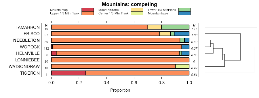
Tigeron-Needleton-Washboard families, complex, 25 to 60 percent slopes | 159 | 12557 | 157838 | 597k | wy656 | 2008 | 1:24000 |
Needleton-Worock-Cowood families, complex, 25 to 60 percent slopes | 143 | 10561 | 157829 | 5978 | wy656 | 2008 | 1:24000 |
Needleton-Worock-Storm families, complex, 15 to 40 percent slopes | 180 | 10545 | 157845 | 597s | wy656 | 2008 | 1:24000 |
Washboard-Worock-Needleton families, complex, 15 to 30 percent slopes | 131 | 7367 | 157855 | 5983 | wy656 | 2008 | 1:24000 |
Garlet-Needleton, families, complex, 10 to 20 percent slopes | 128 | 4150 | 157853 | 5981 | wy656 | 2008 | 1:24000 |
Storm-Cowood-Needleton families, complex, 10 to 60 percent slopes | 148 | 3682 | 157833 | 597d | wy656 | 2008 | 1:24000 |
Needleton-Washboard families, complex, 25 to 50 percent slopes | 157 | 3101 | 157837 | 597j | wy656 | 2008 | 1:24000 |
Needleton family-Inceptic Haplocryalfs-Owlcreek familiy, complex, 5 to 35 percent slopes -- draft | 322 | 20832 | 152002 | 5359 | wy663 | 2012 | 1:24000 |
Coldfeet-Needleton families, complex, 0 to 30 percent slopes | 353 | 12404 | 152016 | 535r | wy663 | 2012 | 1:24000 |
Needleton-Coldfeet families, complex, 5 to 40 percent slopes | 343 | 2867 | 152013 | 535n | wy663 | 2012 | 1:24000 |
Needleton-Kingmine-Cluff families, complex, 10 to 40 percent slopes | 323 | 2429 | 152003 | 535b | wy663 | 2012 | 1:24000 |
Vertic Haplocryalfs-Needleton family, complex, 0 to 30 percent slopes | 363 | 487 | 152019 | 535v | wy663 | 2012 | 1:24000 |
Needleton family-Inceptic Haplocryalfs-Owlcreek familiy, complex, 5 to 35 percent slopes -- draft | 322 | 30 | 2771632 | 5359 | wy723 | | 1:24000 |
