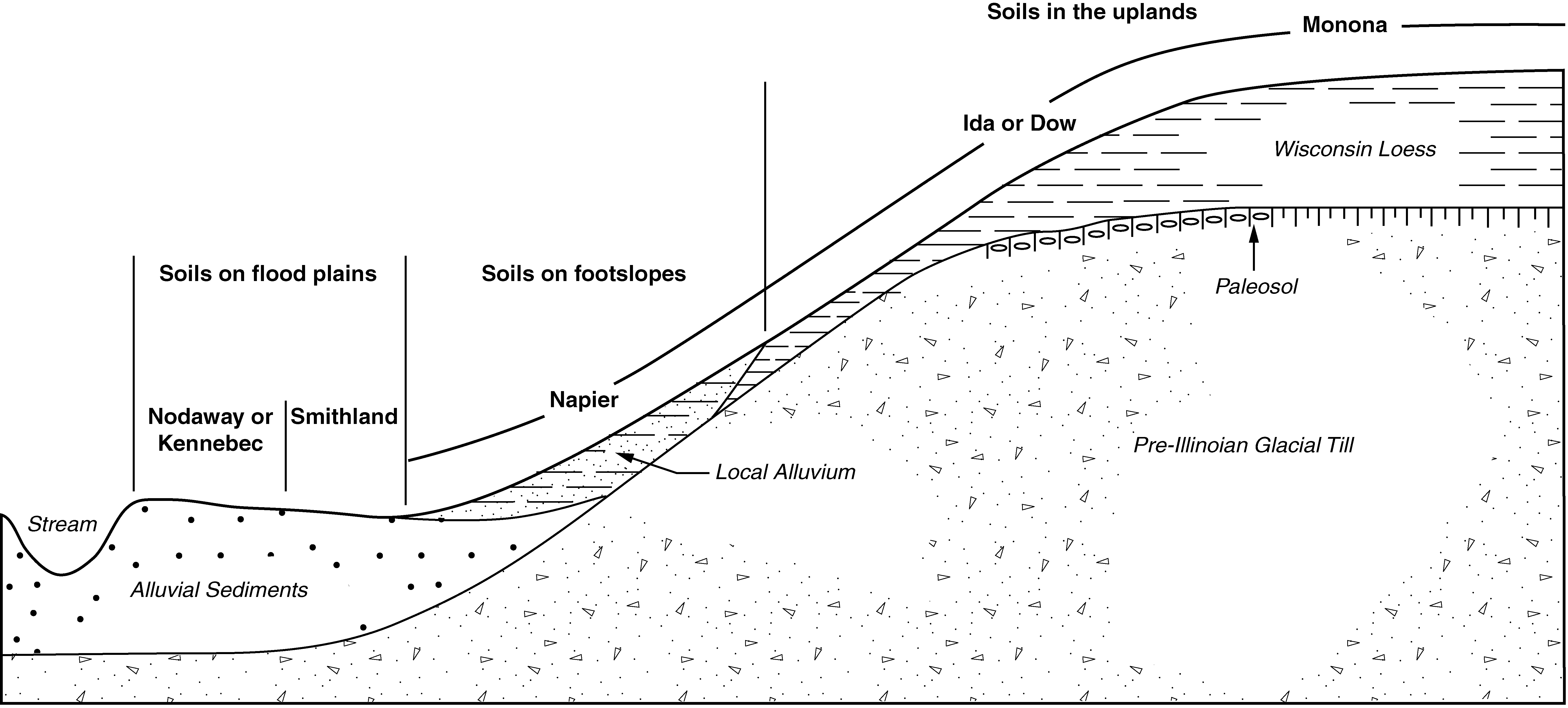
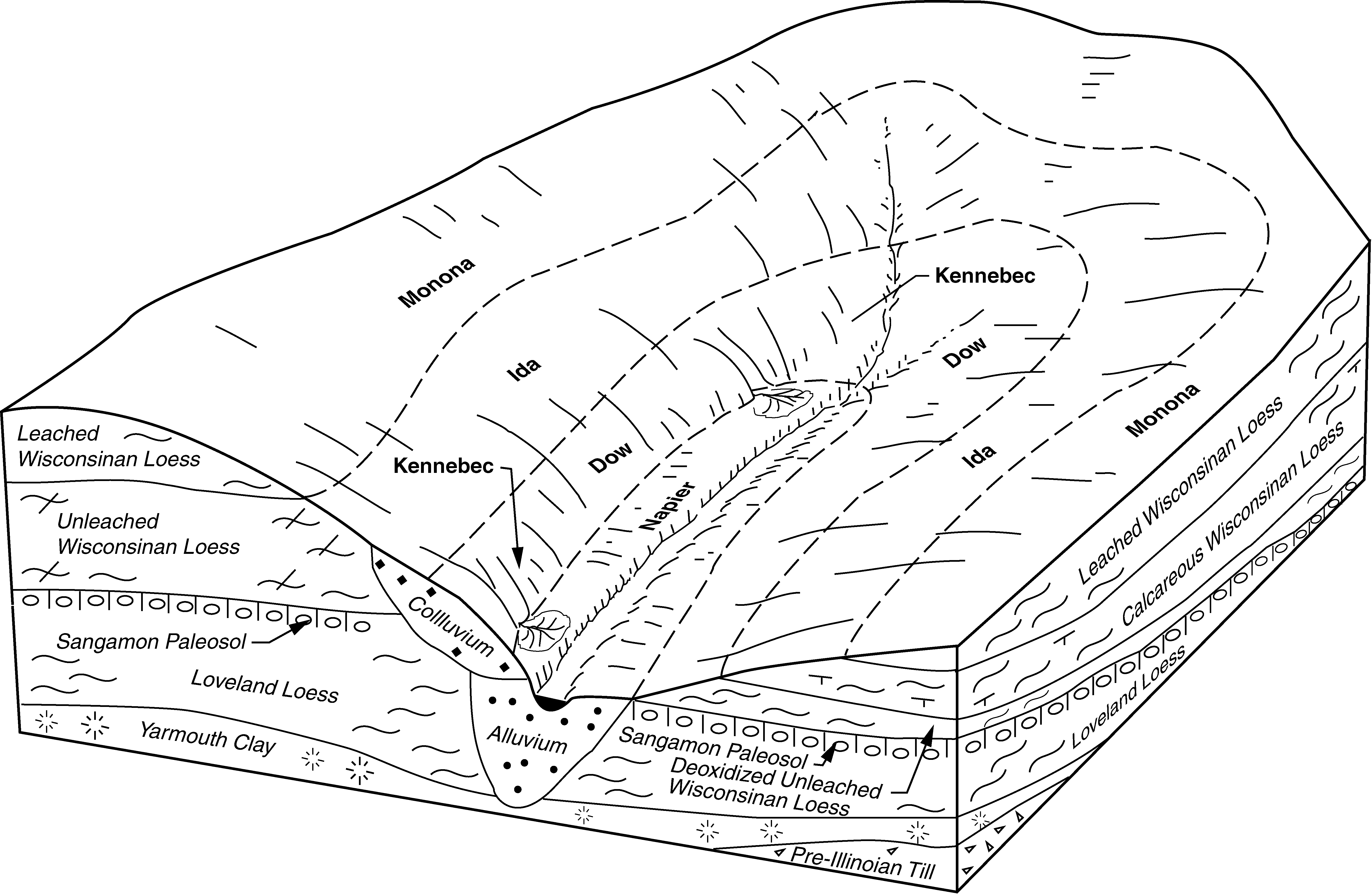
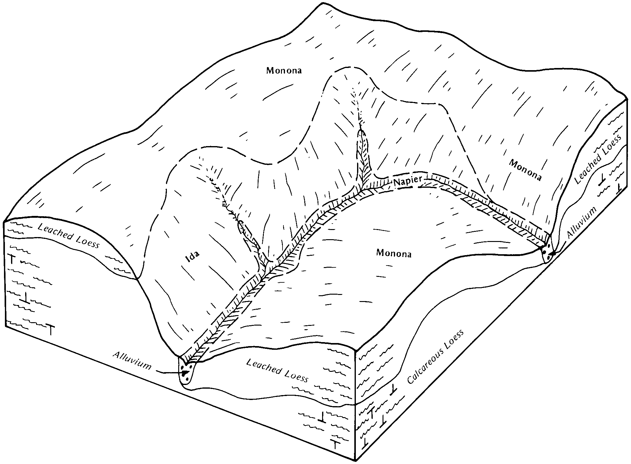
| Napier-Kennebec-Colo complex, 0 to 5 percent slopes | 17B | 7745 | 399796 | 2wnyl | ia047 | 2004 | 1:12000 |
Napier silt loam, 2 to 5 percent slopes | 12B | 7490 | 399791 | 2sy76 | ia047 | 2004 | 1:12000 |
Napier silt loam, 5 to 9 percent slopes | 12C | 7299 | 399792 | 2sy78 | ia047 | 2004 | 1:12000 |
Napier-Gullied land complex, 5 to 14 percent slopes | 717D | 956 | 399849 | 2sy7d | ia047 | 2004 | 1:12000 |
Napier silt loam, 2 to 5 percent slopes | 12B | 15139 | 406091 | 2sy76 | ia071 | 1968 | 1:20000 |
Napier-Gullied land complex, 2 to 10 percent slopes | 717C | 4513 | 406165 | 2sy7c | ia071 | 1968 | 1:20000 |
Napier silt loam, 5 to 9 percent slopes | 12C | 972 | 406092 | 2sy78 | ia071 | 1968 | 1:20000 |
Napier silt loam, 5 to 9 percent slopes | 12C | 35546 | 406728 | 2sy78 | ia085 | 1971 | 1:15840 |
Napier silt loam, 2 to 5 percent slopes | 12B | 32867 | 406726 | 2sy76 | ia085 | 1971 | 1:15840 |
Napier silt loam, 9 to 14 percent slopes | 12D | 7343 | 406729 | 2sy79 | ia085 | 1971 | 1:15840 |
Napier-Nodaway-Colo complex, 2 to 5 percent slopes | 17B | 2702 | 406739 | 2y6b1 | ia085 | 1971 | 1:15840 |
Napier silt loam, 2 to 5 percent slopes, overwash | 12B+ | 1764 | 406727 | 2sy77 | ia085 | 1971 | 1:15840 |
Napier-Gullied land complex, 2 to 10 percent slopes | 717C | 778 | 406785 | 2sy7c | ia085 | 1971 | 1:15840 |
Napier silt loam, 2 to 5 percent slopes | 12B | 22629 | 409532 | 2sy76 | ia129 | 1979 | 1:15840 |
Napier-Gullied land complex, 2 to 10 percent slopes | 717 | 3621 | 409592 | 2sy7c | ia129 | 1979 | 1:15840 |
Napier silt loam, 5 to 9 percent slopes | 12C | 1576 | 409533 | 2sy78 | ia129 | 1979 | 1:15840 |
Napier silt loam, 5 to 9 percent slopes | 12C | 34956 | 447312 | 2sy78 | ia133 | 1994 | 1:12000 |
Napier silt loam, 9 to 14 percent slopes | 12D | 16938 | 447313 | 2sy79 | ia133 | 1994 | 1:12000 |
Napier silt loam, 2 to 5 percent slopes | 12B | 8997 | 447311 | 2sy76 | ia133 | 1994 | 1:12000 |
Napier-Kennebec-Colo complex, 0 to 5 percent slopes | 17B | 2480 | 447314 | 2wnyl | ia133 | 1994 | 1:12000 |
Napier-Gullied land complex, 5 to 14 percent slopes | 717D | 1867 | 447389 | 2sy7d | ia133 | 1994 | 1:12000 |
Napier silt loam, 5 to 9 percent slopes | 12C | 6444 | 410319 | 2sy78 | ia149 | 1972 | 1:20000 |
Napier-Castana silt loams, 9 to 14 percent slopes | 170D | 4991 | 410325 | 2xbln | ia149 | 1972 | 1:20000 |
Napier-Gullied land complex, 2 to 10 percent slopes | 717C | 817 | 410357 | 2sy7c | ia149 | 1972 | 1:20000 |
Napier silt loam, 2 to 5 percent slopes | 12B | 43356 | 410438 | 2sy76 | ia155 | 1986 | 1:15840 |
Napier silt loam, 5 to 9 percent slopes | 12C | 13542 | 410439 | 2sy78 | ia155 | 1986 | 1:15840 |
Napier silt loam, 9 to 14 percent slopes | 12D | 1311 | 410440 | 2sy79 | ia155 | 1986 | 1:15840 |
Napier-Gullied land complex, 2 to 10 percent slopes | 717C | 543 | 410512 | 2sy7c | ia155 | 1986 | 1:15840 |
Napier-Urban land complex, 2 to 5 percent slopes | 4012B | 530 | 410483 | 2sy7g | ia155 | 1986 | 1:15840 |
Napier silt loam, 2 to 5 percent slopes | 12B | 620 | 626719 | 2sy76 | ia165 | 2005 | 1:12000 |
Napier silt loam, 5 to 9 percent slopes | 12C | 295 | 626721 | 2sy78 | ia165 | 2005 | 1:12000 |
Napier silt loam, 5 to 9 percent slopes | 12C | 29846 | 401837 | 2sy78 | ia193 | 2003 | 1:12000 |
Napier silt loam, 2 to 5 percent slopes | 12B | 10375 | 401836 | 2sy76 | ia193 | 2003 | 1:12000 |
Napier-Rawles complex, 2 to 5 percent slopes | 47B | 9602 | 401924 | fh79 | ia193 | 2003 | 1:12000 |
Napier-Castana silt loams, 9 to 20 percent slopes | 170E | 7046 | 741625 | 2xblp | ia193 | 2003 | 1:12000 |
Napier-Gullied land complex, 5 to 14 percent slopes | 717D | 2919 | 401959 | 2sy7d | ia193 | 2003 | 1:12000 |
Napier-Urban land complex, 5 to 9 percent slopes | 4012C | 2115 | 402133 | 2sy7h | ia193 | 2003 | 1:12000 |
Napier-Urban land complex, 2 to 5 percent slopes | 4012B | 984 | 401917 | 2sy7g | ia193 | 2003 | 1:12000 |
Napier-Castana-Urban land complex, 9 to 14 percent slopes | 4170D | 228 | 402135 | 2xblq | ia193 | 2003 | 1:12000 |
Napier-Kennebec-Colo complex, 0 to 5 percent slopes | 17B | 91 | 402131 | 2wnyl | ia193 | 2003 | 1:12000 |
Napier silt loam, 2 to 5 percent slopes | 13560 | 7310 | 2528427 | 2sy76 | mo005 | 1988 | 1:24000 |
Napier-Gullied land complex, 5 to 14 percent slopes | 13628 | 3208 | 2671844 | 2qhz6 | mo005 | 1988 | 1:24000 |
Gullied land-Napier complex, 1 to 5 percent slopes | 10168 | 1511 | 902692 | 2y6b0 | mo005 | 1988 | 1:24000 |
Napier-Gullied land complex, 5 to 14 percent slopes | 13628 | 7643 | 2671845 | 2qhz6 | mo087 | 1992 | 1:24000 |
Napier silt loam, 2 to 5 percent slopes | 13560 | 2658 | 2528426 | 2sy76 | mo087 | 1992 | 1:24000 |
Motark-Napier silt loams, 1 to 7 percent slopes | 13555 | 1492 | 902767 | z9dj | mo087 | 1992 | 1:24000 |
Napier-Gullied land complex, 1 to 7 percent slopes | 13562 | 687 | 902771 | 2sy7b | mo087 | 1992 | 1:24000 |
Napier silt loam, 2 to 5 percent slopes | 13561 | 914 | 887144 | 2sy76 | mo089 | 1975 | 1:24000 |
Napier silt loam, 0 to 3 percent slopes | 12503 | 1923 | 886672 | yrnb | mo095 | 1982 | 1:24000 |
Napier-Nodaway-Gullied land complex, 0 to 60 percent slopes | 8108 | 12 | 2216688 | 2wnyh | ne021 | 1978 | 1:20000 |
Napier silt loam, 11 to 17 percent slopes | 8106 | 4454 | 426755 | gb29 | ne043 | 1972 | 1:20000 |
Napier-Gullied land complex, 2 to 10 percent slopes | 8107 | 1084 | 426756 | 2sy7c | ne043 | 1972 | 1:20000 |
Napier-Nodaway-Gullied land complex, 0 to 60 percent slopes | 8108 | 1918 | 395534 | 2wnyh | ne177 | 2000 | 1:12000 |
Gullied land-Napier complex, 5 to 60 percent slopes | 9932 | 942 | 395519 | 2sy7f | ne177 | 2000 | 1:12000 |


