Official Series Description


Lab Data Summary

Aggregate lab data for the NAFF soil series. This aggregation is based on all pedons with a current taxon name of NAFF, and applied along 1-cm thick depth slices. Solid lines are the slice-wise median, bounded on either side by the interval defined by the slice-wise 5th and 95th percentiles. The median is the value that splits the data in half. Five percent of the data are less than the 5th percentile, and five percent of the data are greater than the 95th percentile. Values along the right hand side y-axis describe the proportion of pedon data that contribute to aggregate values at this depth. For example, a value of "90%" at 25cm means that 90% of the pedons correlated to NAFF were used in the calculation. Source: KSSL snapshot . Methods used to assemble the KSSL snapshot used by SoilWeb / SDE

Click the image to view it full size.

Pedons used in the lab summary:

MLRALab IDPedon IDTaxonnameCINSSL / NASIS ReportsLink To SoilWeb GMap
977-ID-297677ID057009Naff5Primary | Supplementary | Taxonomy | Pedon | Water Retention | Correlation | Andic Soil Properties46.532,-116.9255
977-ID-297777ID057010Naff5Primary | Supplementary | Taxonomy | Pedon | Water Retention | Correlation | Andic Soil Properties46.7477,-116.9907
985P024584ID069014NAFF6Primary | Supplementary | Taxonomy | Pedon | Water Retention | Correlation | Andic Soil Properties46.4041672,-116.6861115
986P006885WA075006Naff7Primary | Supplementary | Taxonomy | Pedon | Water Retention | Correlation | Andic Soil Properties46.9874992,-117.4772186
999P0330REPORT TESTING PEDONNaff6Primary | Supplementary | Taxonomy | Pedon | Water Retention | Correlation | Andic Soil Properties47.2939224,-117.2277985

Water Balance

Monthly water balance estimated using a leaky-bucket style model for the NAFF soil series. Monthly precipitation (PPT) and potential evapotranspiration (PET) have been estimated from the 50th percentile of gridded values (PRISM 1981-2010) overlapping with the extent of SSURGO map units containing each series as a major component. Monthly PET values were estimated using the method of Thornthwaite (1948). These (and other) climatic parameters are calculated with each SSURGO refresh and provided by the fetchOSD function of the soilDB package. Representative water storage values (“AWC” in the figures) were derived from SSURGO by taking the 50th percentile of profile-total water storage (sum[awc_r * horizon thickness]) for each soil series. Note that this representation of “water storage” is based on the average ability of most plants to extract soil water between 15 bar (“permanent wilting point”) and 1/3 bar (“field capacity”) matric potential. Soil moisture state can be roughly interpreted as “dry” when storage is depleted, “moist” when storage is between 0mm and AWC, and “wet” when there is a surplus. Clearly there are a lot of assumptions baked into this kind of monthly water balance. This is still a work in progress.

Click the image to view it full size.


Click the image to view it full size.

Sibling Summary

Siblings are those soil series that occur together in map units, in this case with the NAFF series. Sketches are arranged according to their subgroup-level taxonomic structure. Source: SSURGO snapshot , parsed OSD records and snapshot of SC database .

Click the image to view it full size.

Select annual climate data summaries for the NAFF series and siblings. Series are sorted according to hierarchical clustering of median values. Source: SSURGO map unit geometry and 1981-2010, 800m PRISM data .

Click the image to view it full size.

Geomorphic description summaries for the NAFF series and siblings. Series are sorted according to hierarchical clustering of proportions and relative hydrologic position within an idealized landform (e.g. top to bottom). Most soil series (SSURGO components) are associated with a hillslope position and one or more landform-specific positions: hills, mountain slopes, terraces, and/or flats. Proportions can be interpreted as an aggregate representation of geomorphic membership. The values printed to the left (number of component records) and right (Shannon entropy) of stacked bars can be used to judge the reliability of trends. Small Shannon entropy values suggest relatively consistent geomorphic association, while larger values suggest lack thereof. Source: SSURGO component records .

Click the image to view it full size.

Click the image to view it full size.

There are insufficient data to create the 3D mountains figure.

Click the image to view it full size.

Click the image to view it full size.

Competing Series

Soil series competing with NAFF share the same family level classification in Soil Taxonomy. Source: parsed OSD records and snapshot of the SC database .

Click the image to view it full size.

Select annual climate data summaries for the NAFF series and competing. Series are sorted according to hierarchical clustering of median values. Source: SSURGO map unit geometry and 1981-2010, 800m PRISM data .

Click the image to view it full size.

Geomorphic description summaries for the NAFF series and competing. Series are sorted according to hierarchical clustering of proportions and relative hydrologic position within an idealized landform (e.g. top to bottom). Proportions can be interpreted as an aggregate representation of geomorphic membership. Most soil series (SSURGO components) are associated with a hillslope position and one or more landform-specific positions: hills, mountain slopes, terraces, and/or flats. The values printed to the left (number of component records) and right (Shannon entropy) of stacked bars can be used to judge the reliability of trends. Shannon entropy values close to 0 represent soil series with relatively consistent geomorphic association, while values close to 1 suggest lack thereof. Source: SSURGO component records .

Click the image to view it full size.

There are insufficient data to create the 3D hills figure.

There are insufficient data to create the 3D mountains figure.

There are insufficient data to create the 3D terrace figure.

There are insufficient data to create the 3D flats position figure.

Soil series sharing subgroup-level classification with NAFF, arranged according to family differentiae. Hovering over a series name will print full classification and a small sketch from the OSD. Source: snapshot of SC database .

Block Diagrams

Click a link below to display the diagram. Note that these diagrams may be from multiple survey areas.

  1. ID-2010-08-30-15 | Lewis and Nez Perce Counties - 2004

    Typical pattern of soils in Naff-Palouse complex, 8 to 20 percent slopes (Soil Survey of Lewis and Nez Perce Counties, Idaho; 2004).

  2. WA-2012-05-11-05 | Whitman County - April 1980

    Typical landscape in the Palouse association (Soil Survey of Whitman County, Washington; April 1980).

  3. WA-2012-05-11-08 | Whitman County - April 1980

    Typical landscape in the Palouse-Thatuna-Naff association (Soil Survey of Whitman County, Washington; April 1980).

Map Units

Map units containing NAFF as a major component. Limited to 250 records.

Map Unit Name Symbol Map Unit Area (ac) Map Unit Key National Map Unit Symbol Soil Survey Area Publication Date Map Scale
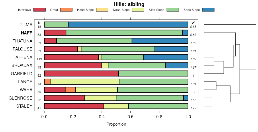
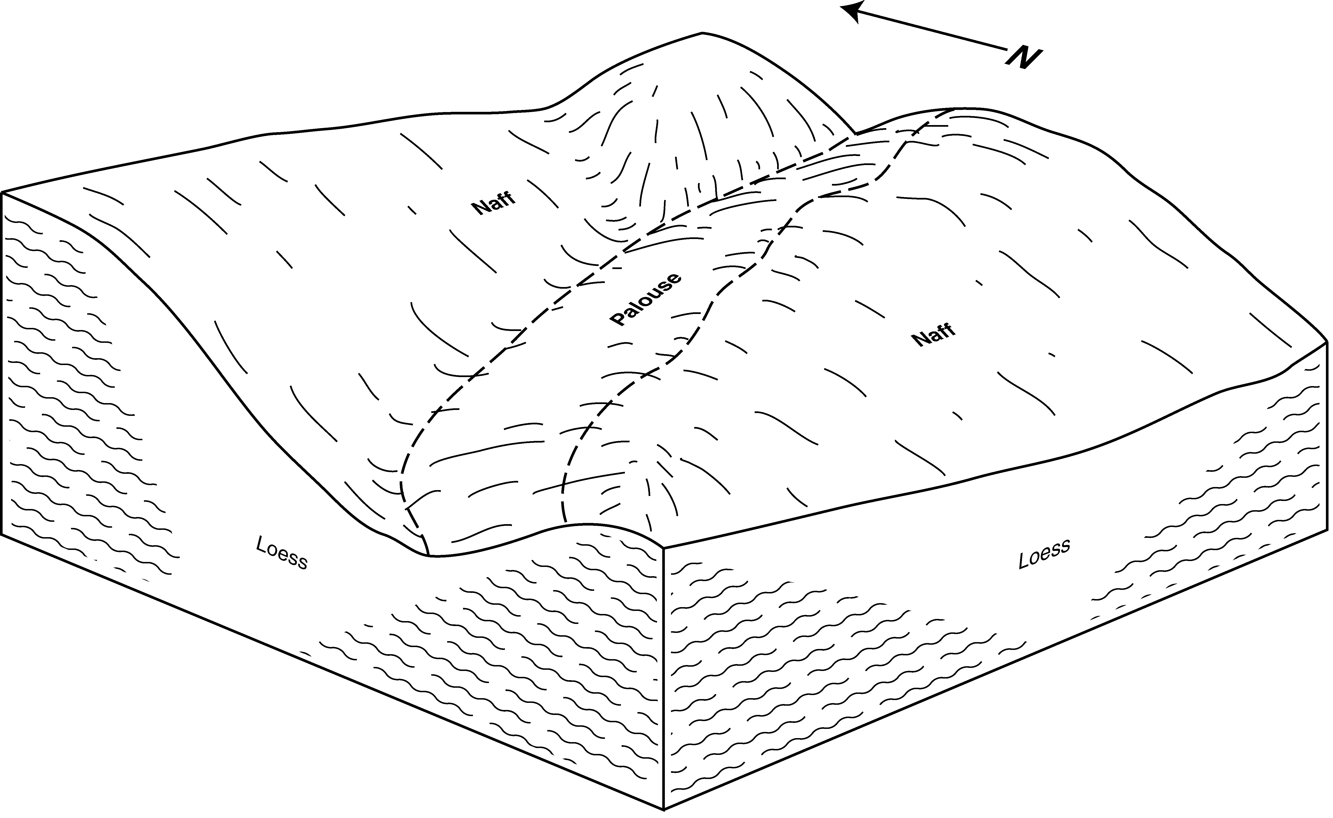
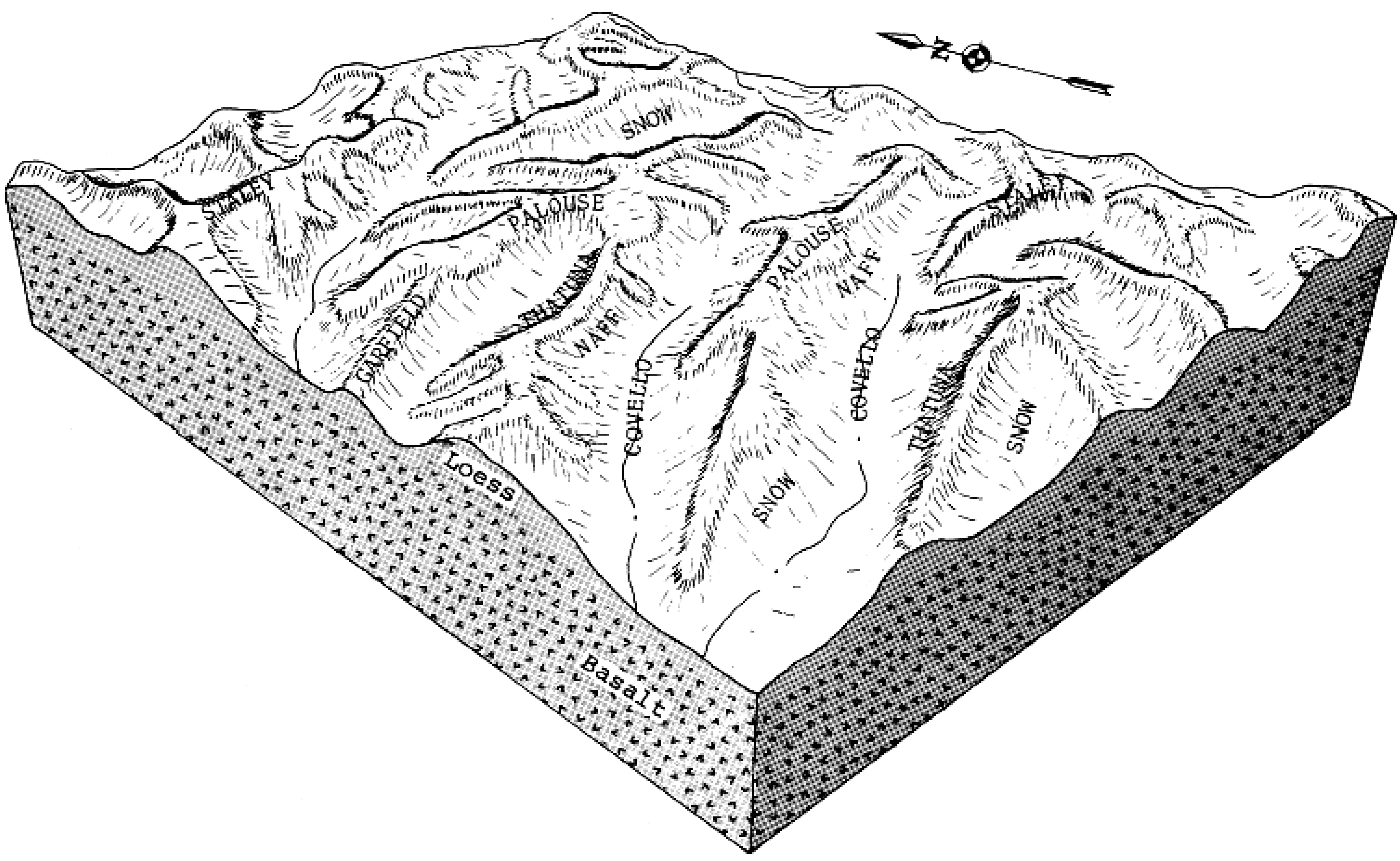
Naff-Palouse complex, 7 to 25 percent slopes332170624872782ph6sid05720131:24000
Naff-Thatuna complex, 7 to 25 percent slopes341322524872792ph6tid05720131:24000
Tilma-Naff complex, 7 to 25 percent slopes56766524873012ph7jid05720131:24000
Thatuna-Naff complex, 25 to 40 percent slopes54337524872992ph7gid05720131:24000
Naff-Palouse complex, 8 to 20 percent slopes9017970797072ny6id61119941:24000
Naff-Palouse complex, 2 to 8 percent slopes896177797052ny4id61119941:24000
Thatuna-Naff-Tilma complex, 10 to 25 percent slopes1365045796032ntvid61119941:24000
Thatuna-Naff, eroded complex, 10 to 25 percent slopes1345040796012ntsid61119941:24000
Naff-Waha complex, 12 to 25 percent slopes954682797122nycid61119941:24000
Thatuna-Naff complex, 10 to 25 percent slopes1334152796002ntrid61119941:24000
Naff, eroded-Palouse-Garfield complex, 8 to 20 percent slopes923132797092ny8id61119941:24000
Naff, eroded-Palouse complex, 8 to 20 percent slopes912851797082ny7id61119941:24000
Naff-Waha complex, 25 to 40 percent slopes962837797132nydid61119941:24000
Thatuna-Naff complex, 25 to 40 percent slopes1352258796022nttid61119941:24000
Naff-Waha complex, 3 to 12 percent slopes942047797112nybid61119941:24000
Naff-Thatuna complex, 2 to 10 percent slopes931998797102ny9id61119941:24000
Naff silt loam, 20 to 30 percent slopes88739797042ny3id61119941:24000
Palouse-Naff complex, 3 to 8 percent slopes410188013898541hn80id62020131:24000
Thatuna-Naff complex, 8 to 25 percent slopes405172613898521hn7yid62020131:24000
Naff-Tilma complex, 3 to 20 percent slopes415141113898571hn83id62020131:24000
Naff-Thatuna complex, 8 to 25 percent slopes416139113898581hn84id62020131:24000
Naff-Palouse complex, 8 to 25 percent slopes417136113898591hn85id62020131:24000
Naff-Thatuna complex, 3 to 8 percent slopes414135713898561hn82id62020131:24000
Naff-Garfield complex, 5 to 25 percent slopes42152023739152kp7xid62020131:24000
Thatuna-Naff complex, 25 to 40 percent slopes40641013898531hn7zid62020131:24000
Naff-Garfield complex, 3 to 15 percent slopes606740431859462wfgwa06320121:24000
Naff-Thatuna complex, 8 to 25 percent slopes606227401859452wffwa06320121:24000
Naff-Garfield complex, 15 to 25 percent slopes606817253859472wfhwa06320121:24000
Thatuna-Naff complex, 15 to 30 percent slopes61318185621223nvfgwa06320121:24000
Naff silt loam, 0 to 8 percent slopes60616990859422wfbwa06320121:24000
Naff silt loam, 8 to 15 percent slopes606469161856530209w2wa06320121:24000
Thatuna-Naff complex, 8 to 15 percent slopes61305263859532wfpwa06320121:24000
Staley-Naff complex, 8 to 25 percent slopes60312801859412wf9wa06320121:24000
Garfield-Naff complex, 8 to 35 percent slopes60211832859482wfjwa06320121:24000
Naff silt loam, 7 to 25 percent slopes59275816855629bhwa07519751:20000
Naff-Garfield complex, 3 to 25 percent slopes61116456855929blwa07519751:20000
Naff-Thatuna complex, 8 to 25 percent slopes6062256126513682wffwa07519751:20000
Naff silt loam, 25 to 40 percent slopes6021386855829bkwa07519751:20000
Thatuna-Naff silt loams, 7 to 25 percent slopes1091739684882989wa07519751:20000
Naff-Garfield complex, 3 to 15 percent slopes6067123526513702wfgwa07519751:20000
Naff-Garfield complex, 15 to 25 percent slopes606878926513712wfhwa07519751:20000
Thatuna-Naff complex, 8 to 25 percent slopes40521327430961hn7ywa07519751:20000
Naff-Thatuna complex, 8 to 25 percent slopes41614127430881hn84wa07519751:20000
Naff-Thatuna complex, 3 to 8 percent slopes4147927430891hn82wa07519751:20000
Naff-Tilma complex, 3 to 20 percent slopes4157827430931hn83wa07519751:20000
Naff-Palouse complex, 8 to 25 percent slopes4176927430901hn85wa07519751:20000
Thatuna-Naff complex, 15 to 30 percent slopes6131552651376nvfgwa07519751:20000
Thatuna-Naff complex, 8 to 15 percent slopes61304926513752wfpwa07519751:20000
Naff-Garfield complex, 5 to 25 percent slopes4214227430872kp7xwa07519751:20000
Palouse-Naff complex, 3 to 8 percent slopes4103927430921hn80wa07519751:20000
Naff silt loam, 8 to 15 percent slopes6064312651369209w2wa07519751:20000
Naff silt loam, 0 to 8 percent slopes60612526513672wfbwa07519751:20000
Staley-Naff complex, 8 to 25 percent slopes60312026513632wf9wa07519751:20000
Thatuna-Naff complex, 25 to 40 percent slopes4061327430911hn7zwa07519751:20000

Map of Series Extent

Approximate geographic distribution of the NAFF soil series. To learn more about how this distribution was mapped, or to compare this soil series extent to others, use the Series Extent Explorer (SEE) application. Source: generalization of SSURGO geometry .