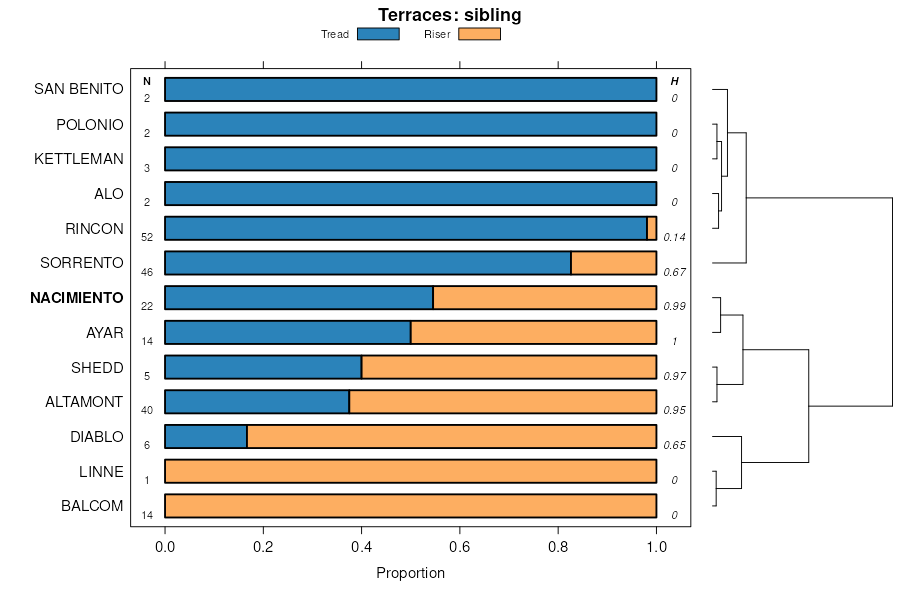
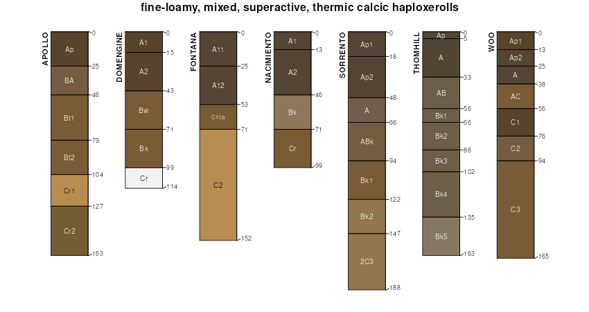
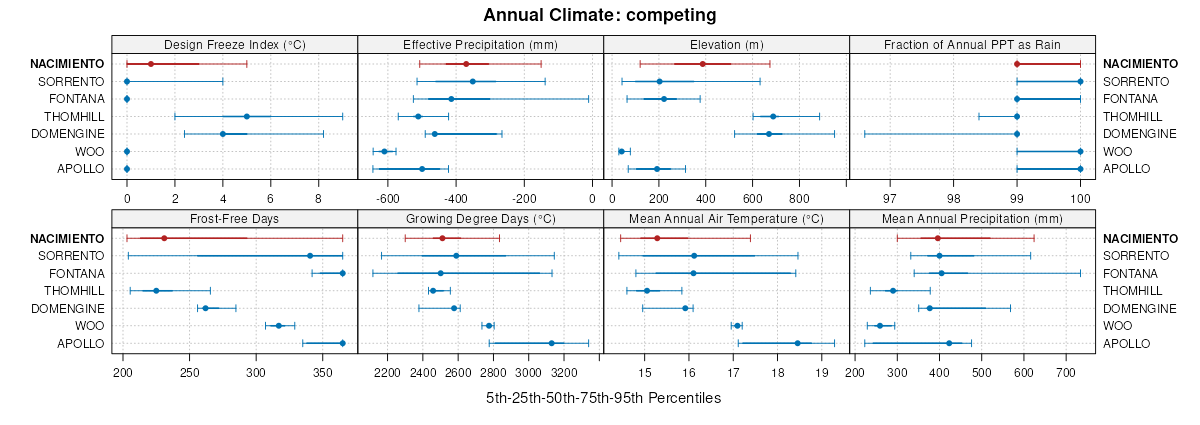
| Nacimiento clay, 15 to 30 percent slopes | NaD | 8953 | 458753 | hdch | ca021 | 1961 | 1:20000 |
Nacimiento-Contra Costa association, 15 to 30 percent slopes | NhD | 3298 | 458762 | hdcs | ca021 | 1961 | 1:20000 |
Nacimiento-Altamont association, 10 to 30 percent slopes | NfD | 2756 | 458759 | hdcp | ca021 | 1961 | 1:20000 |
Nacimiento-Contra Costa association, 30 to 50 percent slopes | NhE | 1814 | 458763 | hdct | ca021 | 1961 | 1:20000 |
Nacimiento-Contra Costa-Gullied land complex, 30 to 50 percent slopes | NkE | 1721 | 458765 | hdcw | ca021 | 1961 | 1:20000 |
Nacimiento-Gullied land complex, 30 to 50 percent slopes | NdE | 1486 | 458758 | hdcn | ca021 | 1961 | 1:20000 |
Nacimiento soils, 10 to 30 percent slopes | NcD | 1424 | 458755 | hdck | ca021 | 1961 | 1:20000 |
Altamont-Nacimiento association, 3 to 15 percent slopes | AmC | 1185 | 458576 | hd5s | ca021 | 1961 | 1:20000 |
Nacimiento soils, 30 to 50 percent slopes | NcE | 884 | 458756 | hdcl | ca021 | 1961 | 1:20000 |
Nacimiento-Contra Costa-Gullied land complex, 15 to 30 percent slopes | NkD | 836 | 458764 | hdcv | ca021 | 1961 | 1:20000 |
Nacimiento clay, 3 to 15 percent slopes | NaC | 592 | 458752 | hdcg | ca021 | 1961 | 1:20000 |
Ayar-Nacimiento clays, 10 to 30 percent slopes | AyD | 558 | 458589 | hd66 | ca021 | 1961 | 1:20000 |
Nacimiento-Altamont-Gullied land complex, 15 to 30 percent slopes | NgD | 456 | 458760 | hdcq | ca021 | 1961 | 1:20000 |
Nacimiento clay, 30 to 50 percent slopes | NaE | 344 | 458754 | hdcj | ca021 | 1961 | 1:20000 |
Naciminto-Gullied land complex, 15 to 30 percent slopes | NdD | 304 | 458757 | hdcm | ca021 | 1961 | 1:20000 |
Nacimiento-Contra Costa association, 3 to 15 percent slopes | NhC | 81 | 458761 | hdcr | ca021 | 1961 | 1:20000 |
Nacimiento-Los Osos complex, 30 to 50 percent slopes, MLRA 15 | NbF | 34765 | 2747740 | 2s0pg | ca053 | 1972 | 1:24000 |
Nacimiento silty clay loam, 30 to 50 percent slopes, MLRA 15 | NaF | 27380 | 2747735 | 2tb72 | ca053 | 1972 | 1:24000 |
Nacimiento-Los Osos complex, 50 to 75 percent slopes, MLRA 15 | NbG | 23600 | 2747741 | 2tb75 | ca053 | 1972 | 1:24000 |
Nacimiento silty clay loam, 15 to 30 percent slopes, MLRA 15 | NaE | 16550 | 2747734 | 2tb70 | ca053 | 1972 | 1:24000 |
Nacimiento silty clay loam, 9 to 15 percent slopes | NaD | 4290 | 455671 | h952 | ca053 | 1972 | 1:24000 |
Nacimiento silty clay loam, 15 to 75 percent slopes, MLRA 15 | NaG | 3200 | 455674 | 2tb98 | ca053 | 1972 | 1:24000 |
Nacimiento loam, 30 to 75 percent slopes, severely erod ed | NcG3 | 12009 | 456246 | h9rm | ca069 | 1965 | 1:20000 |
Nacimiento clay loam, 30 to 50 percent slopes, eroded | NaF2 | 7551 | 456244 | h9rk | ca069 | 1965 | 1:20000 |
Nacimiento clay loam, 50 to 75 percent slopes, eroded | NaG2 | 2392 | 456245 | h9rl | ca069 | 1965 | 1:20000 |
Nacimiento clay loam, 15 to 30 percent slopes, MLRA 15 | NaE | 1795 | 456243 | 2tb93 | ca069 | 1965 | 1:20000 |
Nacimiento clay loam, 50 to 75 percent slopes | 225 | 338 | 2562633 | 2q3fc | ca069 | 1965 | 1:20000 |
Nacimiento clay loam, 30 to 50 percent slopes, MLRA 15 | 224 | 330 | 2562630 | 2tb95 | ca069 | 1965 | 1:20000 |
Nacimiento clay loam, 9 to 15 percent slopes | NaD | 198 | 456242 | h9rh | ca069 | 1965 | 1:20000 |
Nacimiento clay loam, 9 to 30 percent slopes, MLRA 20, warm MAAT | 223 | 151 | 2562638 | 2tb97 | ca069 | 1965 | 1:20000 |
Nacimiento-Newville complex, 10 to 30 percent slopes | NhD | 11260 | 460869 | hgkr | ca645 | 1961 | 1:20000 |
Nacimiento-Altamont complex, 10 to 30 percent slopes, eroded | NcD2 | 6488 | 460866 | hgkn | ca645 | 1961 | 1:20000 |
Nacimiento-Newville complex, 30 to 50 percent slopes | NhE | 6453 | 460871 | hgkt | ca645 | 1961 | 1:20000 |
Nacimiento-Newville complex, 30 to 50 percent slopes, eroded | NhE2 | 6408 | 460872 | hgkv | ca645 | 1961 | 1:20000 |
Nacimiento-Altamont complex, 30 to 50 percent slopes, eroded | NcE2 | 4155 | 460867 | hgkp | ca645 | 1961 | 1:20000 |
Nacimiento-Newville complex, 3 to 10 percent slopes | NhB | 3504 | 460868 | hgkq | ca645 | 1961 | 1:20000 |
Nacimiento-Newville complex, 10 to 30 percent slopes, eroded | NhD2 | 2425 | 460870 | hgks | ca645 | 1961 | 1:20000 |
Nacimiento-Altamont complex, 3 to 10 percent slopes | NcB | 2329 | 460864 | hgkl | ca645 | 1961 | 1:20000 |
Nacimiento silty clay loam, 10 to 30 percent slopes | NaD | 1695 | 460860 | hgkg | ca645 | 1961 | 1:20000 |
Nacimiento silty clay loam, 30 to 50 percent slopes, warm MAAT, MLRA 15 | NaE | 1479 | 2747736 | 2tb73 | ca645 | 1961 | 1:20000 |
Nacimiento-Altamont complex, 10 to 30 percent slopes | NcD | 1474 | 460865 | hgkm | ca645 | 1961 | 1:20000 |
Nacimiento silty clay loam, 10 to 30 percent slopes, eroded | NaD2 | 439 | 460861 | hgkh | ca645 | 1961 | 1:20000 |
Nacimiento silty clay loam, 30 to 50 percent slopes, eroded, warm MAAT, MLRA 15 | NaE2 | 410 | 460863 | 2w61f | ca645 | 1961 | 1:20000 |
Nacimiento-Calodo complex, 30 to 50 percent slopes | 181 | 5255 | 457153 | hbpw | ca664 | 1977 | 1:24000 |
Nacimiento silty clay loam, 30 to 50 percent slopes, MLRA 15 | 178 | 4070 | 2747737 | 2tb72 | ca664 | 1977 | 1:24000 |
Nacimiento-Calodo complex, 50 to 75 percent slopes | 182 | 1625 | 457154 | hbpx | ca664 | 1977 | 1:24000 |
Nacimiento-Calodo complex, 15 to 30 percent slopes | 180 | 1280 | 457152 | hbpv | ca664 | 1977 | 1:24000 |
Nacimiento silty clay loam, 15 to 75 percent slopes, MLRA 15 | 179 | 1120 | 457151 | 2tb98 | ca664 | 1977 | 1:24000 |
Nacimiento silty clay loam, 15 to 30 percent slopes | 177 | 560 | 457149 | hbpr | ca664 | 1977 | 1:24000 |
Nacimiento-Los Osos complex, 9 to 30 percent slopes | 179 | 53095 | 457282 | hbv1 | ca665 | 1977 | 1:24000 |
Nacimiento-Los Osos complex, 30 to 50 percent slopes | 180 | 38070 | 457283 | hbv2 | ca665 | 1977 | 1:24000 |
Balcom-Nacimiento association, moderately steep | 114 | 24500 | 457217 | hbry | ca665 | 1977 | 1:24000 |
Nacimiento-Ayar complex, 9 to 30 percent slopes | 177 | 15695 | 457280 | hbtz | ca665 | 1977 | 1:24000 |
Balcom-Nacimiento association,steep | 115 | 13720 | 457218 | hbrz | ca665 | 1977 | 1:24000 |
Nacimiento-Los Osos complex, 50 to 75 percent slopes | 181 | 9130 | 457284 | hbv3 | ca665 | 1977 | 1:24000 |
Nacimiento silty clay loam, 9 to 30 percent slopes | 175 | 6800 | 457278 | hbtx | ca665 | 1977 | 1:24000 |
Nacimiento-Ayar complex, 30 to 50 percent slopes | 178 | 6260 | 457281 | hbv0 | ca665 | 1977 | 1:24000 |
Nacimiento silty clay loam, 30 to 50 percent slopes, MLRA 15 | 176 | 5550 | 2747738 | 2tb72 | ca665 | 1977 | 1:24000 |
Nacimiento-Kilmer complex, 9 to 30 percent slopes | 205 | 5160 | 463750 | hkkp | ca666 | 1983 | 1:24000 |
Nacimiento-Kilmer complex, 30 to 50 percent slopes | 206 | 3370 | 463751 | hkkq | ca666 | 1983 | 1:24000 |
Balcom-Nacimiento complex, 30 to 50 percent slopes | 102 | 30065 | 458427 | hd0z | ca667 | 2003 | 1:24000 |
Balcom-Nacimiento complex, 15 to 30 percent slopes | 101 | 20785 | 458426 | hd0y | ca667 | 2003 | 1:24000 |
Kilmer-Nacimiento-Aido complex, 30 to 60 percent slopes | 134 | 9010 | 458438 | hd1b | ca667 | 2003 | 1:24000 |
Nacimiento clay loam, 15 to 30 percent slopes, MLRA 15 | 251 | 1915 | 458470 | 2tb93 | ca667 | 2003 | 1:24000 |
Calleguas-Nacimiento complex, 9 to 30 percent slopes | 114 | 1795 | 458432 | hd14 | ca667 | 2003 | 1:24000 |
Nacimiento clay loam, 30 to 50 percent slopes, MLRA 15 | 252 | 855 | 458471 | 2tb95 | ca667 | 2003 | 1:24000 |
Balcom-Nacimiento complex, 9 to 15 percent slopes | 103 | 600 | 458428 | hd10 | ca667 | 2003 | 1:24000 |
Nacimiento loam, 30 to 50 percent slopes, eroded | 152 | 1320 | 463856 | hkp3 | ca670 | 1977 | 1:24000 |
Nacimiento loam, 50 to 75 percent slopes, eroded | 153 | 1147 | 463857 | hkp4 | ca670 | 1977 | 1:24000 |
Nacimiento-Landslide , 30 to 75 percent slopes | NbG | 2262 | 457657 | hc74 | ca673 | 1974 | 1:24000 |
Nacimiento silty clay loam, 30 to 50 percent slopes, eroded | NaF2 | 740 | 3356359 | 2zwtx | ca673 | 1974 | 1:24000 |
Nacimiento silty clay loam, 30 to 50 percent slopes, warm MAAT, MLRA 20 | NaF | 8697 | 2747739 | 2tb74 | ca674 | 1968 | 1:24000 |
Nacimiento silty clay loam, 15 to 75 percent slopes, MLRA 20, warm MAAT | NaG | 6237 | 457745 | 2tb99 | ca674 | 1968 | 1:24000 |
Nacimiento silty clay loam, 15 to 30 percent slopes, eroded | NaE2 | 1769 | 457743 | hc9x | ca674 | 1968 | 1:24000 |
Nacimiento silty clay loam, 9 to 15 percent slopes, eroded | NaD2 | 509 | 457742 | hc9w | ca674 | 1968 | 1:24000 |
Counterfeit-Nacimiento, warm-Urban land association, 20 to 55 percent slopes | 1241LA | | 2911747 | 2pt4h | ca677 | 1972 | 1:24000 |
Nacimiento clay loam, 30 to 50 percent slopes, MLRA 20, warm MAAT | NaF | 3030 | 457974 | 2tb96 | ca677 | 1972 | 1:24000 |
Nacimiento clay loam, 9 to 30 percent slopes, MLRA 20, warm MAAT | NaE | 1270 | 457973 | 2tb97 | ca677 | 1972 | 1:24000 |
Nacimiento clay loam, 30 to 50 percent slopes, MLRA 20, warm MAAT | 181 | 670 | 458082 | 2tb96 | ca678 | 1974 | 1:24000 |
Nacimiento clay loam, 15 to 30 percent slopes, MLRA 20, warm MAAT | 180 | 630 | 458081 | 2tb94 | ca678 | 1974 | 1:24000 |
Counterfeit-Nacimiento, warm-Urban land association, 20 to 55 percent slopes | 1241 | 4547 | 2513729 | 2pt4h | ca696 | 2016 | 1:24000 |
Balcom-Nacimiento, warm complex, 30 to 75 percent slopes | 1149 | 746 | 2670254 | 2rshs | ca696 | 2016 | 1:24000 |
Nacimiento clay loam, 15 to 30 percent slopes, MLRA 20, warm MAAT | 180oc | 287 | 2562691 | 2tb94 | ca696 | 2016 | 1:24000 |
Nacimiento clay loam, 30 to 50 percent slopes, MLRA 20, warm MAAT | 181oc | 100 | 2562692 | 2tb96 | ca696 | 2016 | 1:24000 |
Nacimiento clay loam, 9 to 30 percent slopes, MLRA 20, warm MAAT | NaEsb | 19 | 2562684 | 2tb97 | ca696 | 2016 | 1:24000 |
Los Osos-Nacimiento families association, 15 to 45 percent slopes | 23 | 4369 | 465289 | hm5b | ca772 | 1981 | 1:24000 |
Kilmer-Nacimiento families association, 10 to 60 percent slopes | 12 | 3508 | 465277 | hm4y | ca772 | 1981 | 1:24000 |
Balcom-Nacimiento complex, 30 to 50 percent slopes | 102cp | 37 | 1412860 | 1jf64 | ca772 | 1981 | 1:24000 |