Official Series Description


Lab Data Summary

Aggregate lab data for the MUSKINGUM soil series. This aggregation is based on all pedons with a current taxon name of MUSKINGUM, and applied along 1-cm thick depth slices. Solid lines are the slice-wise median, bounded on either side by the interval defined by the slice-wise 5th and 95th percentiles. The median is the value that splits the data in half. Five percent of the data are less than the 5th percentile, and five percent of the data are greater than the 95th percentile. Values along the right hand side y-axis describe the proportion of pedon data that contribute to aggregate values at this depth. For example, a value of "90%" at 25cm means that 90% of the pedons correlated to MUSKINGUM were used in the calculation. Source: KSSL snapshot . Methods used to assemble the KSSL snapshot used by SoilWeb / SDE

Click the image to view it full size.

Pedons used in the lab summary:

MLRALab IDPedon IDTaxonnameCINSSL / NASIS ReportsLink To SoilWeb GMap
120A95P018493IL151026EMuskingum6Primary | Supplementary | Taxonomy | Pedon | Water Retention | Correlation | Andic Soil Properties37.5314561,-88.6686595
12540A50091959TN141028Muskingum6Primary | Supplementary | Taxonomy | Pedon | Water Retention | Correlation | Andic Soil Properties36.1355553,-85.2408371
12540A50101959TN141029Muskingum6Primary | Supplementary | Taxonomy | Pedon | Water Retention | Correlation | Andic Soil Properties36.1319427,-85.214447
12579P024779WV067009Muskingum6Primary | Supplementary | Taxonomy | Pedon | Water Retention | Correlation | Andic Soil Properties38.4347229,-80.7844467
147VPI0186V1992-VA091-186Muskingum2Primary | Supplementary | Taxonomy | Pedon | Water Retention | Correlation | Andic Soil Properties38.5584167,-79.6657222
n/aFA-s031951-OH045-S03Muskingum4Primary | Supplementary | Taxonomy | Pedon | Water Retention | Correlation | Andic Soil Propertiesn/a
n/aMG-S021954-OH105-S02Muskingum3Primary | Supplementary | Taxonomy | Pedon | Water Retention | Correlation | Andic Soil Propertiesn/a
n/aNB-s011957-OH121-S01Muskingum3Primary | Supplementary | Taxonomy | Pedon | Water Retention | Correlation | Andic Soil Propertiesn/a
n/aCO-0411958-OH029-041Muskingum2Primary | Supplementary | Taxonomy | Pedon | Water Retention | Correlation | Andic Soil Propertiesn/a
n/aCO-0681958-OH029-068Muskingum3Primary | Supplementary | Taxonomy | Pedon | Water Retention | Correlation | Andic Soil Propertiesn/a
n/aCO-0741958-OH029-074Muskingum3Primary | Supplementary | Taxonomy | Pedon | Water Retention | Correlation | Andic Soil Propertiesn/a
n/aCO-0751958-OH029-075Muskingum3Primary | Supplementary | Taxonomy | Pedon | Water Retention | Correlation | Andic Soil Propertiesn/a
n/aCO-0761958-OH029-076Muskingum2Primary | Supplementary | Taxonomy | Pedon | Water Retention | Correlation | Andic Soil Propertiesn/a
n/aCO-0781958-OH029-078Muskingum3Primary | Supplementary | Taxonomy | Pedon | Water Retention | Correlation | Andic Soil Propertiesn/a
n/aCO-0841958-OH029-084Muskingum3Primary | Supplementary | Taxonomy | Pedon | Water Retention | Correlation | Andic Soil Propertiesn/a
n/aCO-0851958-OH029-085Muskingum4Primary | Supplementary | Taxonomy | Pedon | Water Retention | Correlation | Andic Soil Propertiesn/a
n/aCS-0011958-OH031-001Muskingum3Primary | Supplementary | Taxonomy | Pedon | Water Retention | Correlation | Andic Soil Propertiesn/a
n/aRO-0451958-OH141-045Muskingum4Primary | Supplementary | Taxonomy | Pedon | Water Retention | Correlation | Andic Soil Propertiesn/a
n/aRO-0461958-OH141-046Muskingum4Primary | Supplementary | Taxonomy | Pedon | Water Retention | Correlation | Andic Soil Propertiesn/a
n/aRO-0471958-OH141-047Muskingum3Primary | Supplementary | Taxonomy | Pedon | Water Retention | Correlation | Andic Soil Propertiesn/a
n/aRO-0481958-OH141-048Muskingum4Primary | Supplementary | Taxonomy | Pedon | Water Retention | Correlation | Andic Soil Propertiesn/a
n/aRO-0521958-OH141-052Muskingum4Primary | Supplementary | Taxonomy | Pedon | Water Retention | Correlation | Andic Soil Propertiesn/a
n/aCO-0881959-OH029-088Muskingum3Primary | Supplementary | Taxonomy | Pedon | Water Retention | Correlation | Andic Soil Propertiesn/a
n/aCO-1061959-OH029-106Muskingum3Primary | Supplementary | Taxonomy | Pedon | Water Retention | Correlation | Andic Soil Propertiesn/a
n/aRO-0491959-OH141-049Muskingum4Primary | Supplementary | Taxonomy | Pedon | Water Retention | Correlation | Andic Soil Propertiesn/a
n/aTU-s011959-OH157-S01Muskingum2Primary | Supplementary | Taxonomy | Pedon | Water Retention | Correlation | Andic Soil Propertiesn/a
n/aAT-0021960-OH009-002Muskingum3Primary | Supplementary | Taxonomy | Pedon | Water Retention | Correlation | Andic Soil Propertiesn/a
n/aCA-0101960-OH019-010Muskingum3Primary | Supplementary | Taxonomy | Pedon | Water Retention | Correlation | Andic Soil Propertiesn/a
n/aCA-0111960-OH019-011Muskingum3Primary | Supplementary | Taxonomy | Pedon | Water Retention | Correlation | Andic Soil Propertiesn/a
n/aHR-0011960-OH067-001Muskingum3Primary | Supplementary | Taxonomy | Pedon | Water Retention | Correlation | Andic Soil Propertiesn/a
n/aMN-0011960-OH111-001Muskingum3Primary | Supplementary | Taxonomy | Pedon | Water Retention | Correlation | Andic Soil Propertiesn/a
n/aMN-0071960-OH111-007Muskingum2Primary | Supplementary | Taxonomy | Pedon | Water Retention | Correlation | Andic Soil Propertiesn/a
n/aMN-0081960-OH111-008Muskingum4Primary | Supplementary | Taxonomy | Pedon | Water Retention | Correlation | Andic Soil Propertiesn/a
n/aMN-0091960-OH111-009Muskingum3Primary | Supplementary | Taxonomy | Pedon | Water Retention | Correlation | Andic Soil Propertiesn/a
n/aMN-0111960-OH111-011Muskingum4Primary | Supplementary | Taxonomy | Pedon | Water Retention | Correlation | Andic Soil Propertiesn/a
n/aCA-w121961-OH019-W12Muskingum3Primary | Supplementary | Taxonomy | Pedon | Water Retention | Correlation | Andic Soil Propertiesn/a
n/aCA-w131961-OH019-W13Muskingum3Primary | Supplementary | Taxonomy | Pedon | Water Retention | Correlation | Andic Soil Propertiesn/a
n/aCS-W011961-OH031-W01Muskingum3Primary | Supplementary | Taxonomy | Pedon | Water Retention | Correlation | Andic Soil Propertiesn/a
n/aCS-W021961-OH031-W02Muskingum3Primary | Supplementary | Taxonomy | Pedon | Water Retention | Correlation | Andic Soil Propertiesn/a
n/aCS-w031961-OH031-W03Muskingum3Primary | Supplementary | Taxonomy | Pedon | Water Retention | Correlation | Andic Soil Propertiesn/a
n/aCS-w041961-OH031-W04Muskingum3Primary | Supplementary | Taxonomy | Pedon | Water Retention | Correlation | Andic Soil Propertiesn/a
n/aCS-w051961-OH031-W05Muskingum3Primary | Supplementary | Taxonomy | Pedon | Water Retention | Correlation | Andic Soil Propertiesn/a
n/aCS-w061961-OH031-W06Muskingum3Primary | Supplementary | Taxonomy | Pedon | Water Retention | Correlation | Andic Soil Propertiesn/a
n/aGR-w011961-OH059-W01Muskingum3Primary | Supplementary | Taxonomy | Pedon | Water Retention | Correlation | Andic Soil Propertiesn/a
n/aGR-w021961-OH059-W02Muskingum2Primary | Supplementary | Taxonomy | Pedon | Water Retention | Correlation | Andic Soil Propertiesn/a
n/aJF-001.11961-OH081-001.1Muskingum3Primary | Supplementary | Taxonomy | Pedon | Water Retention | Correlation | Andic Soil Propertiesn/a
n/aJF-0021961-OH081-002Muskingum3Primary | Supplementary | Taxonomy | Pedon | Water Retention | Correlation | Andic Soil Propertiesn/a
n/aMN-0191961-OH111-019Muskingum4Primary | Supplementary | Taxonomy | Pedon | Water Retention | Correlation | Andic Soil Propertiesn/a
n/aMN-0211961-OH111-021Muskingum4Primary | Supplementary | Taxonomy | Pedon | Water Retention | Correlation | Andic Soil Propertiesn/a
n/aMN-w011961-OH111-W01Muskingum4Primary | Supplementary | Taxonomy | Pedon | Water Retention | Correlation | Andic Soil Propertiesn/a
n/aMN-w021961-OH111-W02Muskingum3Primary | Supplementary | Taxonomy | Pedon | Water Retention | Correlation | Andic Soil Propertiesn/a
n/aMN-w061961-OH111-W06Muskingum3Primary | Supplementary | Taxonomy | Pedon | Water Retention | Correlation | Andic Soil Propertiesn/a
n/aMN-w071961-OH111-W07Muskingum4Primary | Supplementary | Taxonomy | Pedon | Water Retention | Correlation | Andic Soil Propertiesn/a
n/aMN-w091961-OH111-W09Muskingum4Primary | Supplementary | Taxonomy | Pedon | Water Retention | Correlation | Andic Soil Propertiesn/a
n/aMN-w111961-OH111-W11Muskingum3Primary | Supplementary | Taxonomy | Pedon | Water Retention | Correlation | Andic Soil Propertiesn/a
n/aMS-w021961-OH119-W02Muskingum3Primary | Supplementary | Taxonomy | Pedon | Water Retention | Correlation | Andic Soil Propertiesn/a
n/aMS-w041961-OH119-W04Muskingum3Primary | Supplementary | Taxonomy | Pedon | Water Retention | Correlation | Andic Soil Propertiesn/a
n/aTU-W031961-OH157-W03Muskingum3Primary | Supplementary | Taxonomy | Pedon | Water Retention | Correlation | Andic Soil Propertiesn/a
n/aTU-w071961-OH157-W07Muskingum3Primary | Supplementary | Taxonomy | Pedon | Water Retention | Correlation | Andic Soil Propertiesn/a
n/aTU-w091961-OH157-W09Muskingum2Primary | Supplementary | Taxonomy | Pedon | Water Retention | Correlation | Andic Soil Propertiesn/a
n/aTU-w101961-OH157-W10Muskingum3Primary | Supplementary | Taxonomy | Pedon | Water Retention | Correlation | Andic Soil Propertiesn/a
n/aCA-w221962-OH019-W22Muskingum3Primary | Supplementary | Taxonomy | Pedon | Water Retention | Correlation | Andic Soil Propertiesn/a
n/aCA-w231962-OH019-W23Muskingum3Primary | Supplementary | Taxonomy | Pedon | Water Retention | Correlation | Andic Soil Propertiesn/a
n/aCA-w241962-OH019-W24Muskingum3Primary | Supplementary | Taxonomy | Pedon | Water Retention | Correlation | Andic Soil Propertiesn/a
n/aHR-W041962-OH067-W04Muskingum3Primary | Supplementary | Taxonomy | Pedon | Water Retention | Correlation | Andic Soil Propertiesn/a
n/aHR-W051962-OH067-W05Muskingum3Primary | Supplementary | Taxonomy | Pedon | Water Retention | Correlation | Andic Soil Propertiesn/a
n/aHR-w071962-OH067-W07Muskingum3Primary | Supplementary | Taxonomy | Pedon | Water Retention | Correlation | Andic Soil Propertiesn/a
n/aHR-w081962-OH067-W08Muskingum3Primary | Supplementary | Taxonomy | Pedon | Water Retention | Correlation | Andic Soil Propertiesn/a
n/aHL-w051962-OH075-W05Muskingum3Primary | Supplementary | Taxonomy | Pedon | Water Retention | Correlation | Andic Soil Propertiesn/a
n/aHL-w061962-OH075-W06Muskingum3Primary | Supplementary | Taxonomy | Pedon | Water Retention | Correlation | Andic Soil Propertiesn/a
n/aHL-w081962-OH075-W08Muskingum3Primary | Supplementary | Taxonomy | Pedon | Water Retention | Correlation | Andic Soil Propertiesn/a
n/aHL-w101962-OH075-W10Muskingum3Primary | Supplementary | Taxonomy | Pedon | Water Retention | Correlation | Andic Soil Propertiesn/a
n/aHL-w121962-OH075-W12Muskingum3Primary | Supplementary | Taxonomy | Pedon | Water Retention | Correlation | Andic Soil Propertiesn/a
n/aJF-w021962-OH081-W02Muskingum2Primary | Supplementary | Taxonomy | Pedon | Water Retention | Correlation | Andic Soil Propertiesn/a
n/aJF-w031962-OH081-W03Muskingum3Primary | Supplementary | Taxonomy | Pedon | Water Retention | Correlation | Andic Soil Propertiesn/a
n/aMG-w011962-OH105-W01Muskingum3Primary | Supplementary | Taxonomy | Pedon | Water Retention | Correlation | Andic Soil Propertiesn/a
n/aMN-w231962-OH111-W23Muskingum3Primary | Supplementary | Taxonomy | Pedon | Water Retention | Correlation | Andic Soil Propertiesn/a
n/aMN-w251962-OH111-W25Muskingum3Primary | Supplementary | Taxonomy | Pedon | Water Retention | Correlation | Andic Soil Propertiesn/a
n/aSK-0261965-OH151-026Muskingum4Primary | Supplementary | Taxonomy | Pedon | Water Retention | Correlation | Andic Soil Propertiesn/a
n/a65KY-125-06965KY-125-069Muskingum4Primary | Supplementary | Taxonomy | Pedon | Water Retention | Correlation | Andic Soil Propertiesn/a
n/a65KY-199-01465KY-199-014Muskingum4Primary | Supplementary | Taxonomy | Pedon | Water Retention | Correlation | Andic Soil Propertiesn/a
n/a71KY-025-00971KY-025-009Muskingum3Primary | Supplementary | Taxonomy | Pedon | Water Retention | Correlation | Andic Soil Propertiesn/a
n/a40A4031S1957WV005001Muskingum5Primary | Supplementary | Taxonomy | Pedon | Water Retention | Correlation | Andic Soil Propertiesn/a
n/a40A4030S1957WV035008Muskingum5Primary | Supplementary | Taxonomy | Pedon | Water Retention | Correlation | Andic Soil Propertiesn/a
n/a40A4072S1973WV039002Muskingum2Primary | Supplementary | Taxonomy | Pedon | Water Retention | Correlation | Andic Soil Propertiesn/a
n/a40A4073S1973WV081001Muskingum2Primary | Supplementary | Taxonomy | Pedon | Water Retention | Correlation | Andic Soil Propertiesn/a

Water Balance

Monthly water balance estimated using a leaky-bucket style model for the MUSKINGUM soil series. Monthly precipitation (PPT) and potential evapotranspiration (PET) have been estimated from the 50th percentile of gridded values (PRISM 1981-2010) overlapping with the extent of SSURGO map units containing each series as a major component. Monthly PET values were estimated using the method of Thornthwaite (1948). These (and other) climatic parameters are calculated with each SSURGO refresh and provided by the fetchOSD function of the soilDB package. Representative water storage values (“AWC” in the figures) were derived from SSURGO by taking the 50th percentile of profile-total water storage (sum[awc_r * horizon thickness]) for each soil series. Note that this representation of “water storage” is based on the average ability of most plants to extract soil water between 15 bar (“permanent wilting point”) and 1/3 bar (“field capacity”) matric potential. Soil moisture state can be roughly interpreted as “dry” when storage is depleted, “moist” when storage is between 0mm and AWC, and “wet” when there is a surplus. Clearly there are a lot of assumptions baked into this kind of monthly water balance. This is still a work in progress.

Click the image to view it full size.


Click the image to view it full size.

Sibling Summary

Siblings are those soil series that occur together in map units, in this case with the MUSKINGUM series. Sketches are arranged according to their subgroup-level taxonomic structure. Source: SSURGO snapshot , parsed OSD records and snapshot of SC database .

Click the image to view it full size.

Select annual climate data summaries for the MUSKINGUM series and siblings. Series are sorted according to hierarchical clustering of median values. Source: SSURGO map unit geometry and 1981-2010, 800m PRISM data .

Click the image to view it full size.

Geomorphic description summaries for the MUSKINGUM series and siblings. Series are sorted according to hierarchical clustering of proportions and relative hydrologic position within an idealized landform (e.g. top to bottom). Most soil series (SSURGO components) are associated with a hillslope position and one or more landform-specific positions: hills, mountain slopes, terraces, and/or flats. Proportions can be interpreted as an aggregate representation of geomorphic membership. The values printed to the left (number of component records) and right (Shannon entropy) of stacked bars can be used to judge the reliability of trends. Small Shannon entropy values suggest relatively consistent geomorphic association, while larger values suggest lack thereof. Source: SSURGO component records .

Click the image to view it full size.

Click the image to view it full size.

Click the image to view it full size.

Click the image to view it full size.

Click the image to view it full size.

Competing Series

Soil series competing with MUSKINGUM share the same family level classification in Soil Taxonomy. Source: parsed OSD records and snapshot of the SC database .

Click the image to view it full size.

Select annual climate data summaries for the MUSKINGUM series and competing. Series are sorted according to hierarchical clustering of median values. Source: SSURGO map unit geometry and 1981-2010, 800m PRISM data .

Click the image to view it full size.

Geomorphic description summaries for the MUSKINGUM series and competing. Series are sorted according to hierarchical clustering of proportions and relative hydrologic position within an idealized landform (e.g. top to bottom). Proportions can be interpreted as an aggregate representation of geomorphic membership. Most soil series (SSURGO components) are associated with a hillslope position and one or more landform-specific positions: hills, mountain slopes, terraces, and/or flats. The values printed to the left (number of component records) and right (Shannon entropy) of stacked bars can be used to judge the reliability of trends. Shannon entropy values close to 0 represent soil series with relatively consistent geomorphic association, while values close to 1 suggest lack thereof. Source: SSURGO component records .

Click the image to view it full size.

Click the image to view it full size.

There are insufficient data to create the 3D mountains figure.

There are insufficient data to create the 3D terrace figure.

There are insufficient data to create the 3D flats position figure.

Soil series sharing subgroup-level classification with MUSKINGUM, arranged according to family differentiae. Hovering over a series name will print full classification and a small sketch from the OSD. Source: snapshot of SC database .

Block Diagrams

Click a link below to display the diagram. Note that these diagrams may be from multiple survey areas.

  1. IN-2012-01-19-40 | Perry County - September 1969

    Relationship of relief and geologic strata to certain of the soil series represented in Perry County. The vertical scale is greatly exaggerated (Soil Survey of Perry County, Indiana; 1969).

  2. KY-2012-01-26-03 | Adair County - April 1964

    Pattern of soils in the Frankstown-Bodine-Westmoreland association (Soil Survey of Adair County (Soil Survey of Adair County, Kentucky; April 1964).

  3. KY-2012-01-26-06 | Adair County - April 1964

    Geological cross section of Adair County showing the relationship of the soils to the underlying rocks (Soil Survey of Adair County (Soil Survey of Adair County, Kentucky; April 1964).

  4. KY-2012-01-26-16 | Bath County - September 1963

    Typical landscape in the mountainous southeastern part of the county showing the topography and the relative position of the Muskingum soils in association 1 (Soil Survey of Bath County, Kentucky; September 1963).

  5. KY-2012-01-26-19 | Bath County - September 1963

    Typical landscape in a river valley and the relative position of the principal soils (Soil Survey of Bath County, Kentucky; September 1963).

  6. KY-2012-01-26-25 | Bath County - September 1963

    Cross section of Bath County showing the major soils and their relationship to the rock formations and to relief (Soil Survey of Bath County, Kentucky; September 1963).

  7. KY-2012-01-27-07 | Caldwell County - September 1966

    Typical pattern of soils and underlying materials in association 1 (Soil Survey of Caldwell County, Kentucky; September 1966).

  8. KY-2012-01-27-08 | Caldwell County - September 1966

    Typical pattern of soils and underlying materials in association 2 (Soil Survey of Caldwell County, Kentucky; September 1966).

  9. KY-2012-01-27-09 | Caldwell County - September 1966

    Typical pattern of soils and underlying materials in association 3 (Soil Survey of Caldwell County, Kentucky; September 1966).

  10. KY-2012-01-27-56 | Elliott County - 1965

    Diagram of Muskingum-Ramsey-Wellston soil association, showing relationship of soil series to topography and parent material (Soil Survey of Elliott County, Kentucky; 1965).

  11. KY-2012-01-27-58 | Elliott County - 1965

    Diagram of Muskingum-Montevallo-Ramsey association, showing relationship of soil series to topography and parent material (Soil Survey of Elliott County, Kentucky; 1965).

  12. KY-2012-01-31-05 | Henderson County - February 1967

    Parent material, position, and pattern of soils in the Loring-Zanesville-Wellston association (Soil Survey of Henderson County, Kentucky; February 1967).

  13. KY-2012-01-31-17 | Jefferson County - June 1966

    Diagram showing general parent material, position, and pattern of dominant soils in the Westmoreland-Litz-Muskingum association (Soil Survey of Jefferson County, Kentucky; June 1966).

  14. KY-2012-02-01-37 | Pike County - June 1990

    Along the Levisa and Russell Forks of the Big Sandy River, the soils in the valleys are in the Nelse-Shelbiana-Udorthents general soil map unit and those on the mountains are in the Marrowbone-Fedscreek-Kimper-Dekalb map unit (Soil Survey of Pike County, Kentucky; June 1990).

  15. KY-2012-02-01-38 | Pike County - June 1990

    Along the major tributaries in Pike County, the soils on the mountains are in the Marrowbone-Fedscreek-Kimper-Dekalb general soil map unit and those in the valleys are in the Yeager-Grigsby-Potomac-Hayter map unit (Soil Survey of Pike County, Kentucky; June 1990).

  16. KY-2012-02-01-39 | Pike County - June 1990

    Along Elkhorn Creek and Pine Mountain, the upper faulted mountains are in the Kimper-Sharondale-Berks-Shelocta general soil map unit, the lower mountains are in the Marrowbone-Fedscreek-Kimper-Dekalb map unit, and the valley is in the Yeager-Grigsby-Potomac-Hayter map unit (Soil Survey of Pike County, Kentucky; June 1990).

Map Units

Map units containing MUSKINGUM as a major component. Limited to 250 records.

Map Unit Name Symbol Map Unit Area (ac) Map Unit Key National Map Unit Symbol Soil Survey Area Publication Date Map Scale
Muskingum stony fine sandy loam, 15 to 25 percent slopesMuE2908523366kklsal01519591:20000
Muskingum stony fine sandy loam, 10 to 15 percent slopesMuD1081523365kklral01519591:20000
Muskingum stony fine sandy loam, 15 to 45 percent slopesMuE79019328935c18tal04319601:20000
Muskingum stony fine sandy loam, 10 to 15 percent slopesMuD1039328934c18sal04319601:20000
Muskingum fine sandy loam, eroded, moderately steepMhE21110330736c34xal09519561:20000
Muskingum fine sandy loam, eroded, strongly slopingMhD2805330735c34wal09519561:20000
Muskingum stony fine sandy loam, strongly slopingMkD555330737c34yal09519561:20000
Muskingum fine sandy loam, eroded, slopingMhC2500330734c34val09519561:20000
Muskingum stony fine sandy loam, eroded, hillyMe1079331125c3kgal10319491:15840
Muskingum and Berks soils, 35 to 70 percent slopes955G2313713958ryxxil06920031:12000
Muskingum and Berks soils, 18 to 35 percent slopes955F2209713957ryxwil06920031:12000
Muskingum and Berks soils, 10 to 18 percent slopes955D104713955ryxtil06920031:12000
Berks, Muskingum, and Weikert soils, 35 to 70 percent slopes793G375714021141j20hil08720051:12000
Berks, Muskingum, and Weikert soils, 18 to 35 percent slopes793F125114021131j20gil08720051:12000
Muskingum and Berks soils, 18 to 35 percent slopes955F29416057901qwypil08720051:12000
Muskingum and Berks soils, 35 to 70 percent slopes955G216087681r01ril08720051:12000
Muskingum and Berks soils, 18 to 35 percent slopes955F188808053w3v7il12720041:12000
Muskingum and Berks soils, 35 to 70 percent slopes955G71808054w3v8il12720041:12000
Muskingum and Berks soils, 10 to 18 percent slopes, eroded955D230808052w3v6il12720041:12000
Muskingum and Berks soils, 10 to 18 percent slopes955D20808051w3v5il12720041:12000
Muskingum and Berks soils, 18 to 35 percent slopes955F7267606800ncf6il15120031:12000
Muskingum and Berks soils, 10 to 18 percent slopes955D1288639880pgv9il15120031:12000
Muskingum and Berks soils, 35 to 70 percent slopes955G1189606801ncf7il15120031:12000
Muskingum and Berks soils, 10 to 18 percent slopes, eroded955D232639881pgvbil15120031:12000
Berks, Muskingum, and Weikert soils, 18 to 35 percent slopes793F279014780431lm0til19920071:12000
Berks, Muskingum, and Weikert soils, 35 to 70 percent slopes793G49214780441lm0vil19920071:12000
Muskingum silt loam, 25 to 50 percent slopesMxG11211616775f7din08119751:15840
Litz-Muskingum silt loams, 30 to 50 percent slopesLmF184549194lfgyky10119641:15840
Frondorf stony complex, 12 to 50 percent slopes (muskingum, stony)FsF20425548712ldzdky14119721:20000
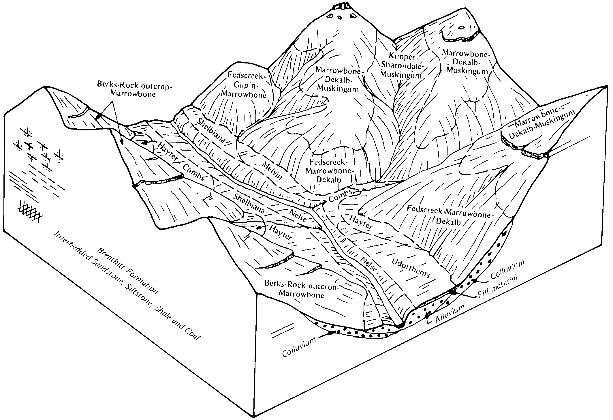
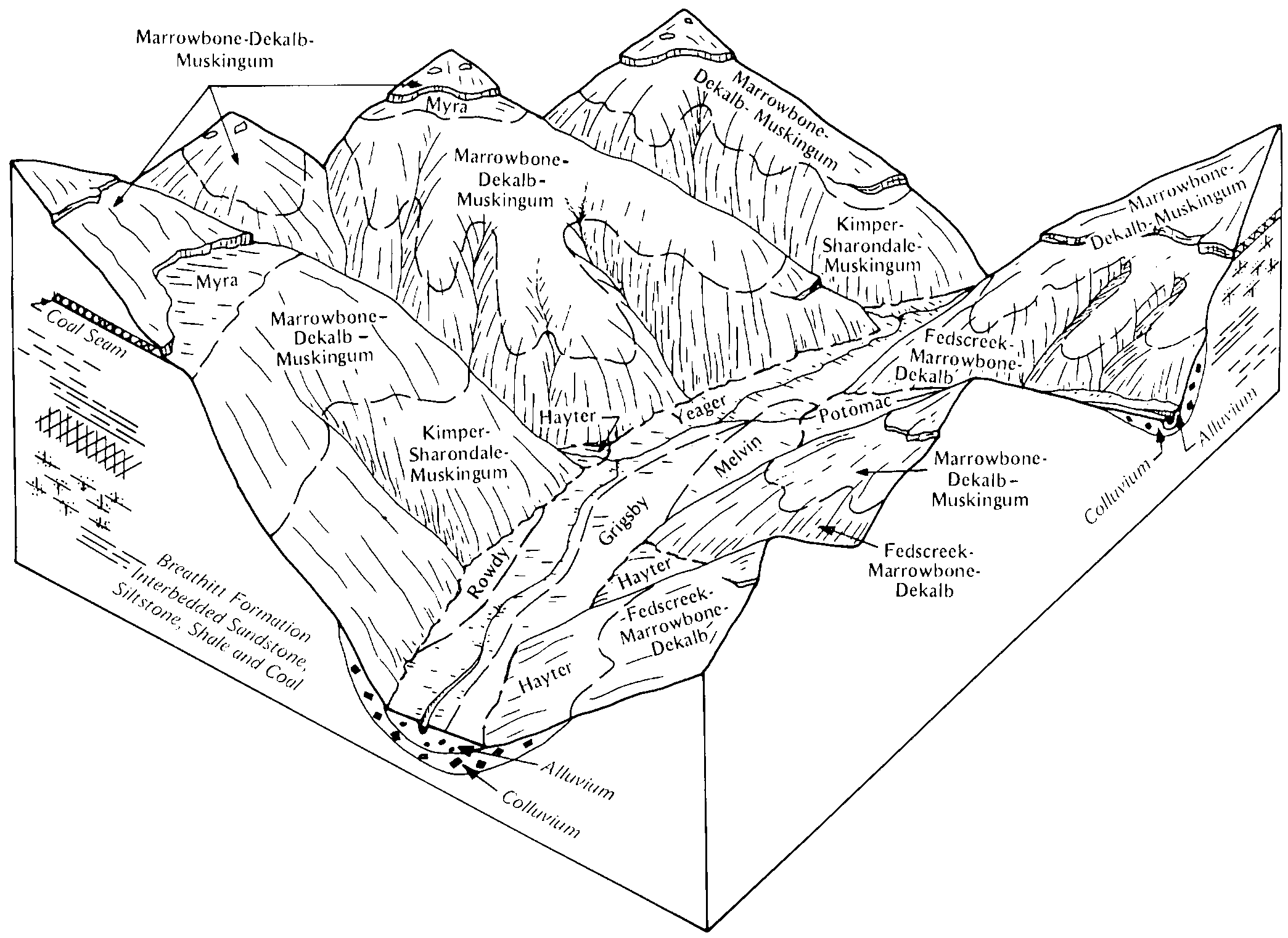
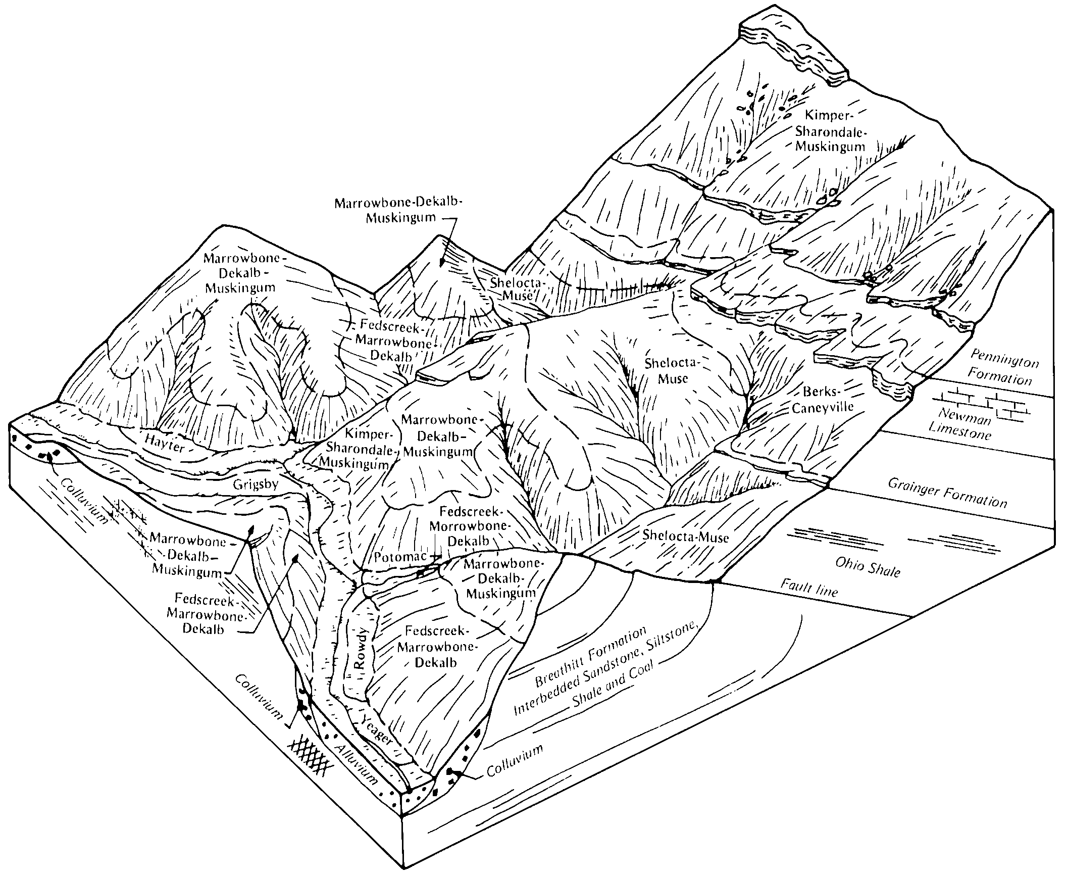
Kimper-Sharondale-Muskingum complex, 30 to 80 percent slopes, very stonyKsF49640550038lgc5ky19519861:24000
Kimper-Sharondale-Muskingum complex, 35 to 80 percent slopes, extremely stonyKmF4993550037lgc4ky19519861:24000
Berks-Muskingum-Neotoma channery silt loams, 35 to 50 percent slopesBhG32314203611jp03oh07119731:15840
Berks-Muskingum channery silt loams, 35 to 50 percent slopesBgG30014203581jp00oh07119731:15840
Berks-Muskingum-Neotoma channery silt loams, 18 to 35 percent slopesBhF27814203601jp02oh07119731:15840
Berks-Muskingum-Neotoma channery silt loams, 6 to 18 percent slopesBhD27014203591jp01oh07119731:15840
Berks-Muskingum channery silt loams, 18 to 35 percent slopesBgF19214203571jnzzoh07119731:15840
Muskingum channery silt loam, 25 to 50 percent slopes, moderately erodedMsF2552816800wdydoh09919661:15840
Muskingum channery silt loam, 2 to 6 percent slopesMsB421816796wdy8oh09919661:15840
Muskingum channery silt loam, 18 to 25 percent slopes, moderately erodedMsE2363816799wdycoh09919661:15840
Muskingum channery silt loam, 12 to 18 percent slopes, moderately erodedMsD2282816798wdyboh09919661:15840
Muskingum channery silt loam, 6 to 12 percent slopes, moderately erodedMsC2257816797wdy9oh09919661:15840
Muskingum and Gilpin silt loams, 18 to 25 percent slopesMvE47652880499nqxoh15119671:15840
Muskingum and Gilpin silt loams, 25 to 35 percent slopesMvF25222880519nqzoh15119671:15840
Muskingum silt loam, 12 to 18 percent slopesMsD23212880489nqwoh15119671:15840
Muskingum silt loam, 6 to 12 percent slopesMsC17382880479nqvoh15119671:15840
Muskingum and Gilpin silt loams, 35 to 50 percent slopesMvG6482880529nr0oh15119671:15840
Muskingum silt loam, 2 to 6 percent slopesMsB3202880469nqtoh15119671:15840
Muskingum and Gilpin-Urban land complex, steepMwF2902880539nr1oh15119671:15840
Muskingum and Gilpin silt loams, 18 to 25 percent slopes, severely erodedMvE31952880509nqyoh15119671:15840
Montevallo and Muskingum soils, steep phasesMm4691526951kpbftn01119511:20000
Montevallo and Muskingum soils, hilly phasesMk815526949kpbctn01119511:20000
Montevallo and Muskingum soils, rolling phasesMl788526950kpbdtn01119511:20000
Muskingum-Sequoia-Petros complex, 30 to 60 percent slopesMkF93306524269kljxtn01319931:24000
Muskingum-Petros complex, 30 to 60 percent slopesMpF8679524271kljztn01319931:24000
Muskingum stony fine sandy loam (st-l)Mf47578524533kltftn02519481:24000
Rough stony land: muskingum soil materialRsM12765524548kltxtn02519481:24000
Muskingum stony fine sandy loam, deep phase (st-l)Mfd3576524534kltgtn02519481:24000
Hartsells (Muskingum) stony fine sandy loam (st-l)Ha524524521klt1tn02519481:24000
Stony colluvium: muskingum soil materialScM504524550kltztn02519481:24000
Muskingum silt loam, 25 to 50 percent slopesMwE984525490kmt9tn08919911:24000
Muskingum-Chiswell complex, 25 to 60 percent slopesMwE1223529699ks62tn60820011:24000
Muskingum silt loam, 20 to 30 percent slopesMuE384024274912mh05tn61019601:15840
Muskingum silt loam, 12 to 20 percent slopesMuD148124274902mh04tn61019601:15840
Muskingum silt loam, 5 to 12 percent slopesMuC62524274892mh03tn61019601:15840

Map of Series Extent

Approximate geographic distribution of the MUSKINGUM soil series. To learn more about how this distribution was mapped, or to compare this soil series extent to others, use the Series Extent Explorer (SEE) application. Source: generalization of SSURGO geometry .