| Muse shaly silt loam, 6 to 10 percent slopes, eroded | MsC2 | 2782 | 328932 | c18q | al043 | 1960 | 1:20000 |
Muse shaly silt loam, 10 to 15 percent slopes | MsD2 | 1589 | 328933 | c18r | al043 | 1960 | 1:20000 |
Muse shaly silt loam, 2 to 6 percent slopes, eroded | MsB2 | 946 | 328931 | c18p | al043 | 1960 | 1:20000 |
Enders and Muse soils, 6 to 15 percent slopes, severely eroded | EsC3 | 597 | 328897 | c17l | al043 | 1960 | 1:20000 |
Muse silt loam, eroded, undulating | Mh | 1500 | 329192 | c1k3 | al049 | 1953 | 1:20000 |
Muse silt loam, eroded, rolling | Mg | 1500 | 329191 | c1k2 | al049 | 1953 | 1:20000 |
Muse silty clay loam, severely eroded, rolling | Mk | 500 | 329193 | c1k4 | al049 | 1953 | 1:20000 |
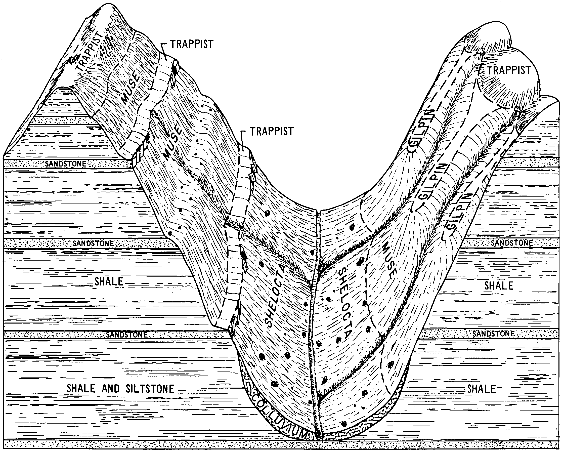
Trappist-Muse silt loams, 20 to 60 percent slopes, eroded | TsF2 | 7111 | 1727522 | 1vzmj | ky011 | 2006 | 1:12000 |
Muse silt loam, 6 to 12 percent slopes, eroded | MuC2 | 539 | 550205 | lgjk | ky049 | 1962 | 1:15840 |
Muse silt loam, 12 to 20 percent slopes, eroded | MuD2 | 317 | 550206 | lgjl | ky049 | 1962 | 1:15840 |
Muse silt loam, 20 to 30 percent slopes, eroded | MuE2 | 161 | 550207 | lgjm | ky049 | 1962 | 1:15840 |
Beetree-Muse complex, 15 to 40 percent slopes, stony | uBemF | 4435 | 2517060 | 2q97j | ky053 | 1990 | 1:20000 |
Beetree-Muse-Zenith complex, 15 to 40 percent slopes, stony | uBenF | 1565 | 2517184 | 2phb4 | ky053 | 1990 | 1:20000 |
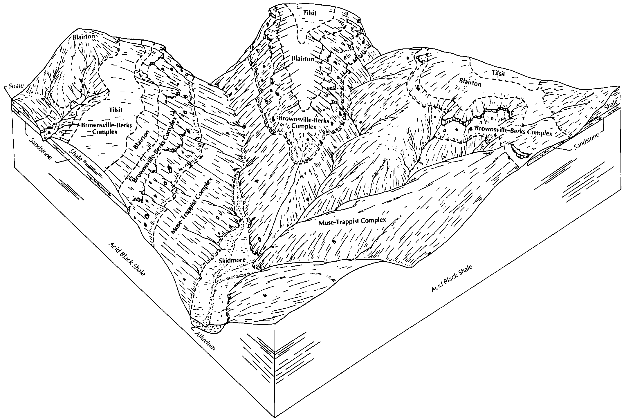
Muse-Trappist complex, 20 to 55 percent slopes, eroded | MuF2 | 18179 | 552727 | lk4x | ky069 | 1989 | 1:20000 |
Muse-Shrouts complex, 6 to 20 percent slopes, severely eroded | MtD3 | 4084 | 552726 | lk4w | ky069 | 1989 | 1:20000 |
Muse channery silt loam, 12 to 20 percent slopes, eroded | MsD2 | 2768 | 552725 | lk4v | ky069 | 1989 | 1:20000 |
Muse channery silt loam, 6 to 12 percent slopes, eroded | MsC2 | 1571 | 552724 | lk4t | ky069 | 1989 | 1:20000 |
Muse channery silt loam, 2 to 6 percent slopes, eroded | MsB2 | 497 | 552723 | lk4s | ky069 | 1989 | 1:20000 |
Muse silt loam, 6 to 12 percent slopes | MuC | 217 | 549776 | lg2q | ky169 | 1965 | 1:15840 |
Shelocta-Muse complex, 15 to 50 percent slopes, very stony | SmE | 1856 | 550050 | lgck | ky195 | 1986 | 1:24000 |
Muse-Shelocta complex, 30 to 50 percent slopes | MuF | 16317 | 552439 | ljvm | ky199 | 1969 | 1:12000 |
Muse-Shelocta complex, 20 to 30 percent slopes | MuE | 4690 | 552437 | ljvk | ky199 | 1969 | 1:12000 |
Muse silt loam, 12 to 20 percent slopes | MoD | 4659 | 552432 | ljvd | ky199 | 1969 | 1:12000 |
Muse-Hartsells complex, 12 to 20 percent slopes | MtD | 3930 | 552435 | ljvh | ky199 | 1969 | 1:12000 |
Muse silt loam, 6 to 12 percent slopes | MoC | 2029 | 552431 | ljvc | ky199 | 1969 | 1:12000 |
Muse-Shelocta complex, 20 to 30 percent slopes, severely eroded | MuE3 | 1046 | 552438 | ljvl | ky199 | 1969 | 1:12000 |
Muse-Shelocta complex, 12 to 20 percent slopes | MuD | 706 | 552436 | ljvj | ky199 | 1969 | 1:12000 |
Muse silty clay loam, 12 to 20 percent slopes, severely eroded | MsD3 | 540 | 552434 | ljvg | ky199 | 1969 | 1:12000 |
Muse silty clay loam, 6 to 12 percent slopes, severely eroded | MsC3 | 119 | 552433 | ljvf | ky199 | 1969 | 1:12000 |
Rigley-Shelocta-Muse complex, steep | RMF | 47145 | 550083 | lgdm | ky231 | 1985 | 1:20000 |
Beetree-Muse-Zenith complex, 15 to 40 percent slopes, stony | uBenF | 27328 | 2517182 | 2phb4 | ky231 | 1985 | 1:20000 |
Beetree-Muse complex, 15 to 40 percent slopes, stony | uBemF | 12488 | 2517058 | 2q97j | ky231 | 1985 | 1:20000 |
Varilla-Beetree-Muse complex, 20 to 45 percent slopes, very stony | uVbmF | 2668 | 2517269 | 2q97l | ky231 | 1985 | 1:20000 |
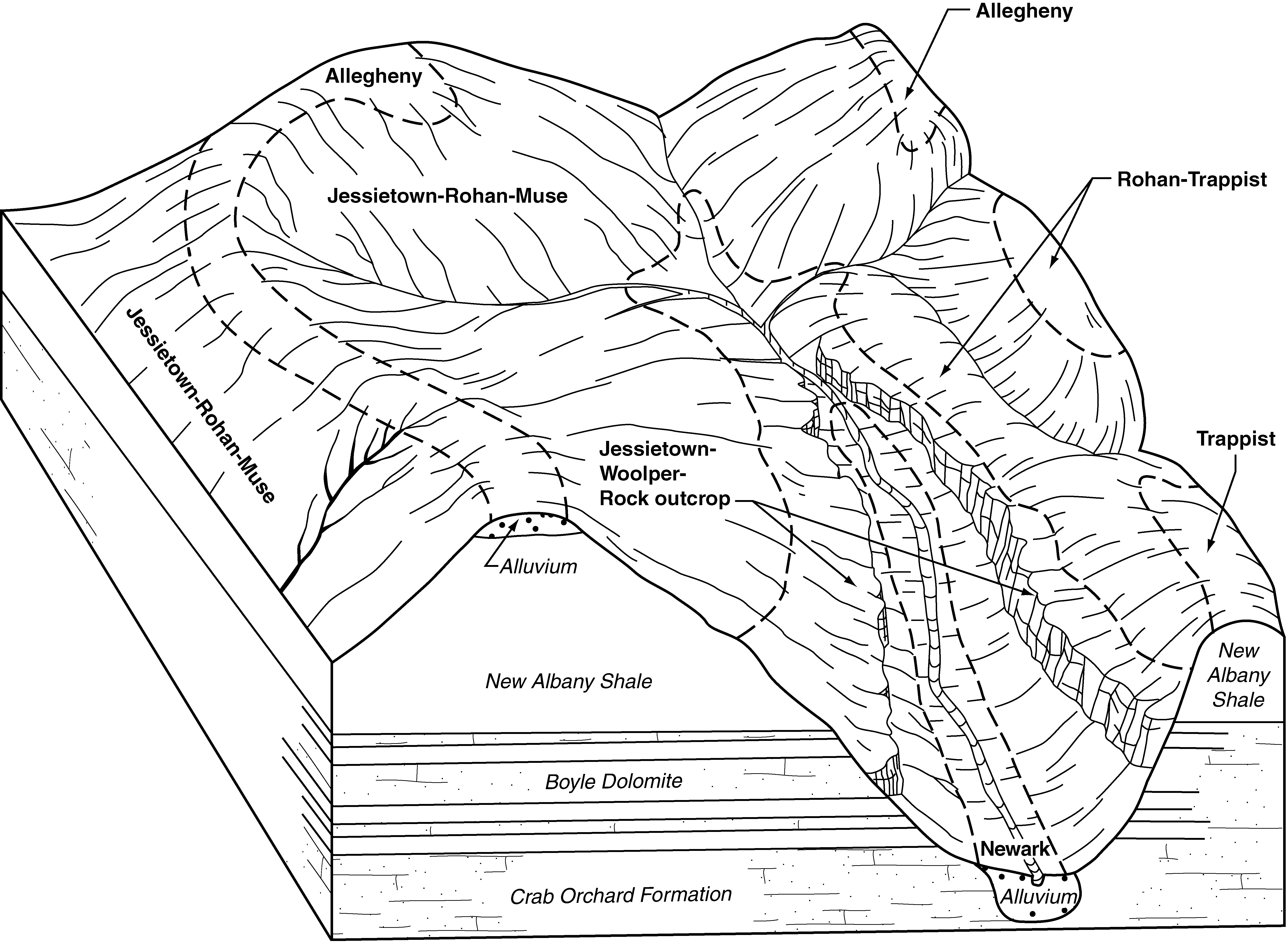
Jessietown-Muse-Rohan complex, 20 to 45 percent slopes | JoF | 10761 | 634703 | p9g9 | ky616 | 2004 | 1:24000 |
Highsplint-Shelocta-Muse complex, 30 to 80 percent slopes, extremely stony | HtF | 1989 | 550739 | lh2s | ky626 | 1997 | 1:24000 |
Shelocta-Muse complex, 15 to 50 percent slopes, very stony | SmF | 231 | 550747 | lh31 | ky626 | 1997 | 1:24000 |
Jessietown-Muse-Rohan complex, 20 to 45 percent slopes | JoF | 10843 | 550838 | lh5z | ky634 | 1989 | 1:20000 |
Muse-Trappist stony silt loams, 30 to 60 percent slopes | MtF | 3720 | 1478809 | 1lmtj | ky645 | 1971 | 1:20000 |
Muse silt loam, 12 to 20 percent slopes | MsD | 470 | 1478807 | 1lmtg | ky645 | 1971 | 1:20000 |
Muse silt loam, 6 to 12 percent slopes | MsC | 360 | 1478806 | 1lmtf | ky645 | 1971 | 1:20000 |
Muse silt loam, 20 to 30 percent slopes | MsE | 250 | 1478808 | 1lmth | ky645 | 1971 | 1:20000 |
Muse silt loam, 2 to 6 percent slopes | MsB | 210 | 1478805 | 1lmtd | ky645 | 1971 | 1:20000 |
Shelocta-Muse-Colyer association, steep | SoE | 33590 | 170122 | 5q0t | oh001 | 1987 | 1:15840 |
Shelocta-Muse association, hilly | SmD | 10867 | 170121 | 5q0s | oh001 | 1987 | 1:15840 |
Trappist-Muse silt loams, 6 to 12 percent slopes, moderately eroded | TsC2 | 443 | 1420531 | 1jp5l | oh071 | 1973 | 1:15840 |
Trappist-Muse silt loams, 12 to 18 percent slopes, moderately eroded | TsD2 | 391 | 1420532 | 1jp5m | oh071 | 1973 | 1:15840 |
Trappist-Muse silt loams, 2 to 6 percent slopes | TsB | 180 | 1420530 | 1jp5k | oh071 | 1973 | 1:15840 |
Shelocta-Muse-Colyer association, steep | SfE | 23 | 1420680 | 1jpbd | oh071 | 1973 | 1:15840 |
Trappist-Muse silt loams, 6 to 12 percent slopes, moderately eroded | TtC2 | 4 | 1689029 | 1tpkt | oh131 | 1984 | 1:15840 |
Shelocta-Muse-Colyer association, steep | SmE | 939 | 1460824 | 1l13c | oh145 | 1984 | 1:15840 |
Muse silt loam, eroded rolling phase | Mv | 2178 | 526959 | kpbp | tn011 | 1951 | 1:20000 |
Muse silt loam, eroded undulating phase | Mw | 810 | 526960 | kpbq | tn011 | 1951 | 1:20000 |
Muse silt loam, rolling phase | Mx | 277 | 526961 | kpbr | tn011 | 1951 | 1:20000 |
Muse silt loam, undulating phase | My | 211 | 526962 | kpbs | tn011 | 1951 | 1:20000 |
Muse silt loam, eroded hilly phase | Mu | 200 | 526958 | kpbn | tn011 | 1951 | 1:20000 |
Beetree-Muse complex, 15 to 40 percent slopes, stony | uBemF | 93 | 2517055 | 2q97j | tn015 | 1999 | 1:24000 |
Muse silt loam, 10 to 20 percent slopes | MuD | 593 | 523889 | kl4n | tn035 | 1998 | 1:24000 |
Muse silt loam, 2 to 5 percent slopes | MuB | 1065 | 525488 | kmt7 | tn089 | 1991 | 1:24000 |
Muse silt loam, 5 to 12 percent slopes | MuC | 1032 | 525489 | kmt8 | tn089 | 1991 | 1:24000 |
Beetree-Muse complex, 15 to 40 percent slopes, stony | uBemF | 6973 | 2517181 | 2q97j | tn133 | 2003 | 1:24000 |
Varilla-Beetree-Muse complex, 20 to 45 percent slopes, very stony | uVbmF | 5817 | 2517271 | 2q97l | tn133 | 2003 | 1:24000 |
Beetree-Muse-Zenith complex, 15 to 40 percent slopes, stony | uBenF | 552 | 2517185 | 2phb4 | tn133 | 2003 | 1:24000 |
Varilla-Beetree-Muse complex, 20 to 45 percent slopes, very stony | uVbmF | 22338 | 2517268 | 2q97l | tn604 | 1974 | 1:20000 |
Beetree-Muse complex, 15 to 40 percent slopes, stony | uBemF | 1753 | 2517057 | 2q97j | tn604 | 1974 | 1:20000 |
Muse silt loam, 5 to 12 percent slopes, eroded | MuC2 | 246 | 524809 | km3b | tn606 | 2001 | 1:24000 |
Muse cobbly loam, 5 to 12 percent slopes, eroded | MxC2 | 78 | 524810 | km3c | tn606 | 2001 | 1:24000 |
Muse silt loam, 5 to 12 percent slopes, eroded | MuC2 | 286 | 529698 | ks61 | tn608 | 2001 | 1:24000 |
Muse silt loam, eroded sloping phase | Mk | 1104 | 1899539 | 21rmg | tn609 | 1955 | 1:20000 |
Muse silt loam, eroded gently sloping phase | Mh | 535 | 1899538 | 21rmf | tn609 | 1955 | 1:20000 |
Muse silt loam, eroded moderately steep phase | Ml | 140 | 1899540 | 21rmh | tn609 | 1955 | 1:20000 |
Varilla-Beetree-Muse complex, 20 to 45 percent slopes, very stony | uVbmF | 9638 | 2517267 | 2q97l | tn610 | 1960 | 1:15840 |
Beetree-Muse complex, 15 to 40 percent slopes, stony | uBemF | 2559 | 2517056 | 2q97j | tn610 | 1960 | 1:15840 |
Varilla-Beetree-Muse complex, 20 to 45 percent slopes, very stony | uVbmF | 19023 | 2517270 | 2q97l | tn701 | 1985 | 1:24000 |
Beetree-Muse complex, 15 to 40 percent slopes, stony | uBemF | 1243 | 2517059 | 2q97j | tn701 | 1985 | 1:24000 |
Beetree-Muse-Zenith complex, 15 to 40 percent slopes, stony | uBenF | 1044 | 2517183 | 2phb4 | tn701 | 1985 | 1:24000 |