| Munising-Yalmer-Frohling complex, calcareous substratum, 1 to 6 percent slopes | 35B | 8749 | 1455263 | 1kv9z | mi003 | 2007 | 1:24000 |
Munising, calcareous substratum-Cookson fine sandy loams, 1 to 6 percent slopes | 275B | 6207 | 1455413 | 1kvgt | mi003 | 2007 | 1:24000 |
Munising-Abbaye fine sandy loams, 1 to 12 percent slopes, dissected, stony | 158C | 6017 | 1455326 | 1kvd0 | mi003 | 2007 | 1:24000 |
Munising-Abbaye fine sandy loams, 1 to 6 percent slopes | 211B | 5353 | 1455359 | 1kvf2 | mi003 | 2007 | 1:24000 |
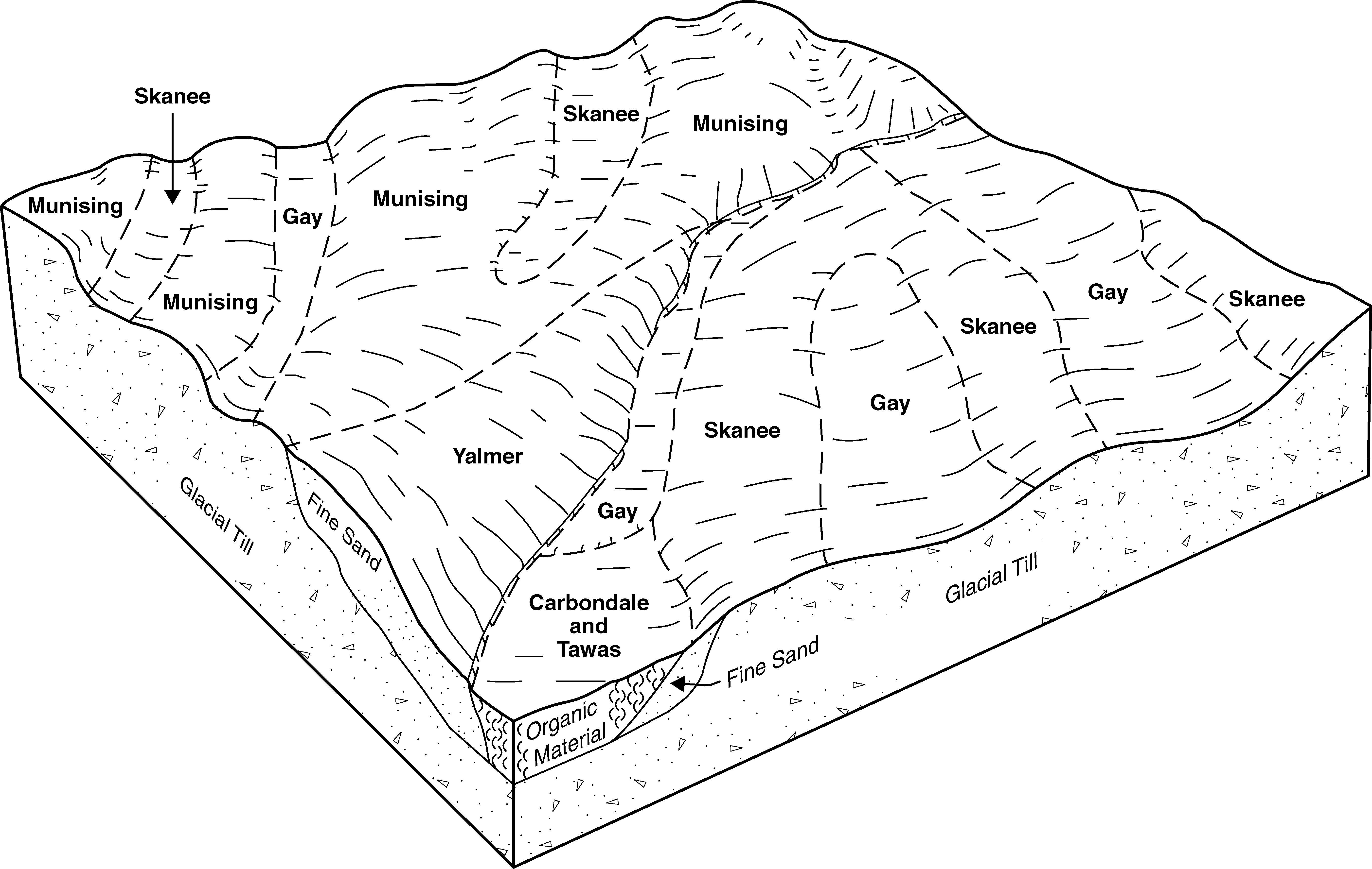
Munising-Skanee complex, 0 to 6 percent slopes, stony | 146B | 3550 | 1455320 | 1kvct | mi003 | 2007 | 1:24000 |
Munising-Yalmer complex, 1 to 12 percent slopes, dissected, very stony | 145C | 3250 | 1455319 | 1kvcs | mi003 | 2007 | 1:24000 |
Munising, calcareous substratum-Frohling, calcareous substratum-Cookson fine sandy loams, 1 to 12 percent slopes, dissected | 268C | 2537 | 1455410 | 1kvgq | mi003 | 2007 | 1:24000 |
Munising-Yalmer-Frohling complex, calcareous substratum, 1 to 12 percent slopes, dissected | 272C | 1367 | 1455412 | 1kvgs | mi003 | 2007 | 1:24000 |
Munising-Yalmer complex, 1 to 6 percent slopes | 25B | 1358 | 1455257 | 1kv9s | mi003 | 2007 | 1:24000 |
Munising, calcareous substratum-Ensley complex, 0 to 6 percent slopes | 135B | 932 | 1455318 | 1kvcr | mi003 | 2007 | 1:24000 |
Munising fine sandy loam, 1 to 6 percent slopes | 24B | 817 | 1455256 | 1kv9r | mi003 | 2007 | 1:24000 |
Munising-Yalmer complex, 6 to 18 percent slopes | 25D | 386 | 1455258 | 1kv9t | mi003 | 2007 | 1:24000 |
Munising-Yalmer loamy sands, 1 to 8 percent slopes | 23B | 22492 | 414958 | fxsr | mi013 | 1984 | 1:20000 |
Munising-Skanee loamy sands, 0 to 6 percent slopes | 39B | 19763 | 414979 | fxtf | mi013 | 1984 | 1:20000 |
Munising loamy sand, 1 to 8 percent slopes | 27B | 19220 | 414964 | fxsy | mi013 | 1984 | 1:20000 |
Munising-Yalmer loamy sands, dissected, 1 to 8 percent slopes | 88B | 7960 | 415033 | fxw5 | mi013 | 1984 | 1:20000 |
Munising-Yalmer loamy sands, 8 to 15 percent slopes | 23D | 4923 | 414959 | fxss | mi013 | 1984 | 1:20000 |
Munising-Yalmer loamy sands, dissected, 8 to 35 percent slopes | 88D | 4777 | 415034 | fxw6 | mi013 | 1984 | 1:20000 |
Munising loamy sand, dissected, 1 to 8 percent slopes | 24B | 1901 | 414960 | fxst | mi013 | 1984 | 1:20000 |
Munising loamy sand, dissected, 8 to 35 percent slopes | 24D | 1828 | 414961 | fxsv | mi013 | 1984 | 1:20000 |
Yalmer-Munising loamy sands, 15 to 35 percent slopes | 69E | 1568 | 415011 | fxvg | mi013 | 1984 | 1:20000 |
Munising-Michigamme complex, rocky, 15 to 35 percent slopes | 115E | 1030 | 414939 | fxs4 | mi013 | 1984 | 1:20000 |
Munising-Michigamme complex, rocky, 8 to 15 percent slopes | 115D | 548 | 414938 | fxs3 | mi013 | 1984 | 1:20000 |
Abbaye-Munising complex, 1 to 15 percent slopes | 8105C | 264 | 2450712 | 2n857 | mi013 | 1984 | 1:20000 |
Munising-Skanee complex, 0 to 8 percent slopes | 30B | 25232 | 416116 | fz03 | mi061 | 1989 | 1:20000 |
Munising loamy fine sand, dissected, 1 to 12 percent slopes | 34B | 18902 | 416121 | fz08 | mi061 | 1989 | 1:20000 |
Munising loamy fine sand, 1 to 8 percent slopes | 10B | 17857 | 416045 | fyxt | mi061 | 1989 | 1:20000 |
Munising-Yalmer complex, dissected, 1 to 12 percent slopes | 98B | 15027 | 416182 | fz27 | mi061 | 1989 | 1:20000 |
Munising-Yalmer complex, 1 to 8 percent slopes | 33B | 13954 | 416119 | fz06 | mi061 | 1989 | 1:20000 |
Munising-Alcona-Liminga complex, dissected, 15 to 70 percent slopes | 130F | 11302 | 416065 | fyyg | mi061 | 1989 | 1:20000 |
Munising-Yalmer complex, dissected, 8 to 35 percent slopes | 98D | 7676 | 416183 | fz28 | mi061 | 1989 | 1:20000 |
Munising-Abbaye-Kalkaska complex, dissected, 1 to 12 percent slopes, rocky | 66B | 5698 | 416148 | fz14 | mi061 | 1989 | 1:20000 |
Munising-Abbaye-Kalkaska complex, dissected, 15 to 70 percent slopes, rocky | 66F | 4779 | 416150 | fz16 | mi061 | 1989 | 1:20000 |
Abbaye-Munising loamy fine sands, 1 to 8 percent slopes | 22B | 4398 | 416109 | fyzw | mi061 | 1989 | 1:20000 |
Munising-Liminga-Alcona complex, 1 to 8 percent slopes | 147B | 3849 | 416088 | fyz6 | mi061 | 1989 | 1:20000 |
Munising loamy fine sand, dissected, 8 to 35 percent slopes | 34D | 2212 | 416122 | fz09 | mi061 | 1989 | 1:20000 |
Munising-Abbaye-Kalkaska complex, dissected, 8 to 35 percent slopes, rocky | 66D | 1945 | 416149 | fz15 | mi061 | 1989 | 1:20000 |
Munising-Alcona-Liminga complex, dissected, 8 to 35 percent slopes | 130D | 1839 | 416064 | fyyf | mi061 | 1989 | 1:20000 |
Abbaye-Munising complex, 1 to 15 percent slopes | 8105C | 1820 | 2483891 | 2pcpj | mi061 | 1989 | 1:20000 |
Munising-Alcona-Liminga complex, dissected, 1 to 12 percent slopes | 130B | 1630 | 416063 | fyyd | mi061 | 1989 | 1:20000 |
Munising loamy fine sand, 8 to 15 percent slopes | 10D | 1361 | 416046 | fyxv | mi061 | 1989 | 1:20000 |
Munising-Yalmer complex, 8 to 15 percent slopes | 33D | 768 | 416120 | fz07 | mi061 | 1989 | 1:20000 |
Munising loamy fine sand, 15 to 35 percent slopes | 10E | 616 | 416047 | fyxw | mi061 | 1989 | 1:20000 |
Munising-Skanee complex, 0 to 6 percent slopes, stony | 146B | 7960 | 395081 | f83k | mi103 | 1999 | 1:24000 |
Munising-Yalmer complex, 1 to 12 percent slopes, dissected, very stony | 145C | 5954 | 395078 | f83g | mi103 | 1999 | 1:24000 |
Munising fine sandy loam, 1 to 6 percent slopes | 24B | 5170 | 395172 | f86h | mi103 | 1999 | 1:24000 |
Munising fine sandy loam, 1 to 12 percent slopes, dissected | 105C | 4863 | 394956 | f7zj | mi103 | 1999 | 1:24000 |
Munising-Onota-Yalmer complex, 1 to 12 percent slopes, dissected, stony | 158C | 2452 | 395102 | f847 | mi103 | 1999 | 1:24000 |
Munising-Yalmer complex, 1 to 6 percent slopes | 25B | 2109 | 395175 | f86l | mi103 | 1999 | 1:24000 |
Munising fine sandy loam, 6 to 18 percent slopes | 24D | 1634 | 395173 | f86j | mi103 | 1999 | 1:24000 |
Keweenaw-Munising complex, 1 to 6 percent slopes | 79B | 1053 | 395279 | f89y | mi103 | 1999 | 1:24000 |
Munising-Yalmer complex, 6 to 18 percent slopes | 25D | 918 | 395176 | f86m | mi103 | 1999 | 1:24000 |
Kalkaska-Munising complex, 1 to 12 percent slopes, dissected | 129C | 851 | 395028 | f81v | mi103 | 1999 | 1:24000 |
Abbaye-Munising complex, 1 to 15 percent slopes | 8105C | 606 | 1674822 | 1t6sj | mi131 | 2007 | 1:24000 |
Munising-Yalmer-Frohling complex, calcareous substratum, 1 to 6 percent slopes | 294B | 161 | 1457039 | 1kx58 | mi153 | 2007 | 1:24000 |
Munising-Skanee complex, dissected, 4 to 18 percent slopes | 185C | 10567 | 801059 | vwkm | mi605 | 2004 | 1:24000 |
Munising-Skanee complex, dissected, 1 to 8 percent slopes | 185B | 6571 | 817769 | wfyn | mi605 | 2004 | 1:24000 |
Munising-Yalmer complex, dissected, 1 to 12 percent slopes | 184C | 5241 | 801604 | vx46 | mi605 | 2004 | 1:24000 |
Munising-Abbaye-Yalmer complex, dissected, 8 to 35 percent slopes, stony | 183E | 2901 | 801605 | vx47 | mi605 | 2004 | 1:24000 |
Munising-Abbaye-Yalmer complex, dissected, 1 to 12 percent slopes, stony | 183C | 2535 | 801606 | vx48 | mi605 | 2004 | 1:24000 |
Munising-Yalmer complex, dissected, 8 to 35 percent slopes | 184E | 2336 | 801603 | vx45 | mi605 | 2004 | 1:24000 |


