Official Series Description


Lab Data Summary

Aggregate lab data for the MORTON soil series. This aggregation is based on all pedons with a current taxon name of MORTON, and applied along 1-cm thick depth slices. Solid lines are the slice-wise median, bounded on either side by the interval defined by the slice-wise 5th and 95th percentiles. The median is the value that splits the data in half. Five percent of the data are less than the 5th percentile, and five percent of the data are greater than the 95th percentile. Values along the right hand side y-axis describe the proportion of pedon data that contribute to aggregate values at this depth. For example, a value of "90%" at 25cm means that 90% of the pedons correlated to MORTON were used in the calculation. Source: KSSL snapshot . Methods used to assemble the KSSL snapshot used by SoilWeb / SDE

Click the image to view it full size.

Pedons used in the lab summary:

MLRALab IDPedon IDTaxonnameCINSSL / NASIS ReportsLink To SoilWeb GMap
5475ND025001B1975ND025101Morton3Primary | Supplementary | Taxonomy | Pedon | Water Retention | Correlation | Andic Soil Properties47.2955556,-102.58
5440A008454ND041003Morton6Primary | Supplementary | Taxonomy | Pedon | Water Retention | Correlation | Andic Soil Properties46.6010704040527,-102.652778625488
5440A008558ND089016Morton7Primary | Supplementary | Taxonomy | Pedon | Water Retention | Correlation | Andic Soil Properties46.8763465881348,-102.727233886719
5440A008658ND089017Morton7Primary | Supplementary | Taxonomy | Pedon | Water Retention | Correlation | Andic Soil Properties46.9630165100098,-102.617782592773
5440A2426S1954SD105004Morton6Primary | Supplementary | Taxonomy | Pedon | Water Retention | Correlation | Andic Soil Properties45.5305557,-102.5952759

Water Balance

Monthly water balance estimated using a leaky-bucket style model for the MORTON soil series. Monthly precipitation (PPT) and potential evapotranspiration (PET) have been estimated from the 50th percentile of gridded values (PRISM 1981-2010) overlapping with the extent of SSURGO map units containing each series as a major component. Monthly PET values were estimated using the method of Thornthwaite (1948). These (and other) climatic parameters are calculated with each SSURGO refresh and provided by the fetchOSD function of the soilDB package. Representative water storage values (“AWC” in the figures) were derived from SSURGO by taking the 50th percentile of profile-total water storage (sum[awc_r * horizon thickness]) for each soil series. Note that this representation of “water storage” is based on the average ability of most plants to extract soil water between 15 bar (“permanent wilting point”) and 1/3 bar (“field capacity”) matric potential. Soil moisture state can be roughly interpreted as “dry” when storage is depleted, “moist” when storage is between 0mm and AWC, and “wet” when there is a surplus. Clearly there are a lot of assumptions baked into this kind of monthly water balance. This is still a work in progress.

Click the image to view it full size.


Click the image to view it full size.

Sibling Summary

Siblings are those soil series that occur together in map units, in this case with the MORTON series. Sketches are arranged according to their subgroup-level taxonomic structure. Source: SSURGO snapshot , parsed OSD records and snapshot of SC database .

Click the image to view it full size.

Select annual climate data summaries for the MORTON series and siblings. Series are sorted according to hierarchical clustering of median values. Source: SSURGO map unit geometry and 1981-2010, 800m PRISM data .

Click the image to view it full size.

Geomorphic description summaries for the MORTON series and siblings. Series are sorted according to hierarchical clustering of proportions and relative hydrologic position within an idealized landform (e.g. top to bottom). Most soil series (SSURGO components) are associated with a hillslope position and one or more landform-specific positions: hills, mountain slopes, terraces, and/or flats. Proportions can be interpreted as an aggregate representation of geomorphic membership. The values printed to the left (number of component records) and right (Shannon entropy) of stacked bars can be used to judge the reliability of trends. Small Shannon entropy values suggest relatively consistent geomorphic association, while larger values suggest lack thereof. Source: SSURGO component records .

Click the image to view it full size.

Click the image to view it full size.

There are insufficient data to create the 3D mountains figure.

Click the image to view it full size.

Click the image to view it full size.

Competing Series

Soil series competing with MORTON share the same family level classification in Soil Taxonomy. Source: parsed OSD records and snapshot of the SC database .

Click the image to view it full size.

Select annual climate data summaries for the MORTON series and competing. Series are sorted according to hierarchical clustering of median values. Source: SSURGO map unit geometry and 1981-2010, 800m PRISM data .

Click the image to view it full size.

Geomorphic description summaries for the MORTON series and competing. Series are sorted according to hierarchical clustering of proportions and relative hydrologic position within an idealized landform (e.g. top to bottom). Proportions can be interpreted as an aggregate representation of geomorphic membership. Most soil series (SSURGO components) are associated with a hillslope position and one or more landform-specific positions: hills, mountain slopes, terraces, and/or flats. The values printed to the left (number of component records) and right (Shannon entropy) of stacked bars can be used to judge the reliability of trends. Shannon entropy values close to 0 represent soil series with relatively consistent geomorphic association, while values close to 1 suggest lack thereof. Source: SSURGO component records .

Click the image to view it full size.

Click the image to view it full size.

There are insufficient data to create the 3D mountains figure.

Click the image to view it full size.

There are insufficient data to create the 3D flats position figure.

Soil series sharing subgroup-level classification with MORTON, arranged according to family differentiae. Hovering over a series name will print full classification and a small sketch from the OSD. Source: snapshot of SC database .

Block Diagrams

Click a link below to display the diagram. Note that these diagrams may be from multiple survey areas.

  1. ND-2010-09-27-17 | Morton County - 2002

    Typical pattern of soils and underlying materials in the Farland-Savage-Amor-Belfield association (Soil Survey of Morton County, North Dakota; 2002).

  2. ND-2010-09-27-19 | Morton County - 2002

    Typical pattern of soils and underlying materials in the Regent-Daglum-Morton association (Soil Survey of Morton County, North Dakota; 2002).

  3. ND-2012-02-07-30 | Dunn County - April 1982

    Typical pattern of soils and underlying material in the Cabba-Cohagen-Rhoades association (Soil Survey of Dunn County, North Dakota; April 1982).

  4. ND-2012-02-07-31 | Dunn County - April 1982

    Typical pattern of soils and underlying material in the Morton-Rhoades-Savage association (Soil Survey of Dunn County, North Dakota; April 1982).

  5. ND-2012-02-07-32 | Dunn County - April 1982

    Typical pattern of soils and underlying material in the Vebar-Parshall association (Soil Survey of Dunn County, North Dakota; April 1982).

  6. ND-2012-02-08-53 | Stark County - February 1968

    Diagram showinig the relationship of some of the major soils in Stark County (Soil Survey of Stark County, North Dakota; February 1968).

Map Units

Map units containing MORTON as a major component. Limited to 250 records.

Map Unit Name Symbol Map Unit Area (ac) Map Unit Key National Map Unit Symbol Soil Survey Area Publication Date Map Scale
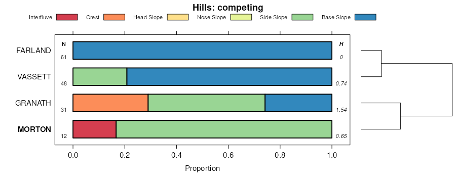
Morton-Farland silt loams, 2 to 8 percent slopes871C2228343725cjnxmt01719951:24000
Morton silt loam, undulatingMw4597346081cm3xmt60719701:24000
Chama, Morton, and Cabba silty clay loams, 6 to 15 percent slopesCnC2099280812b32nd01119691:20000
Chama and Morton silty clay loams, 3 to 6 percent slopesCmB899280712b31nd01119691:20000
Morton-Farland silt loams, 3 to 6 percent slopesE2927B19926616981vzv5nd01519671:20000
Morton-Farland silt loams, 3 to 6 percent slopesE2927B1768627072101vzv5nd02519811:20000
Belfield-Morton silt loams, 3 to 6 percent slopesE2401B693927072062r4gwnd02519811:20000
Morton-Cabba silt loams, 6 to 9 percent slopesE2931C693327072112r8l6nd02519811:20000
Belfield-Morton silt loams, 0 to 3 percent slopesE2401A256427072052r4gvnd02519811:20000
Morton-Farland silt loams, 0 to 3 percent slopesE2927A126427072091vzv4nd02519811:20000
Morton-Farland silt loams, 3 to 6 percent slopesE2927B1017155001vzv5nd03719851:20000
Morton-Farland silt loams, 3 to 6 percent slopesE2927B2527556861vzv5nd04119861:20000
Morton-Farland silt loams, 0 to 3 percent slopesE2927A1927556851vzv4nd04119861:20000
Morton silty clay loam, 0 to 3 percent slopesE2919A1327556832r8l3nd04119861:20000
Morton silty clay loam, 3 to 6 percent slopesE2919B527556842r8l4nd04119861:20000
Morton-Cabba silt loams, 6 to 9 percent slopesE2931C1249226991942r8l6nd05919981:20000
Morton-Farland silt loams, 3 to 6 percent slopesE2927B1155217183581vzv5nd05919981:20000
Morton-Farland silt loams, 3 to 6 percent slopesE2927B937425259541vzv5nd06519711:20000
Morton-Werner silt loams, 6 to 9 percent slopesE2933C568825259552r6v2nd06519711:20000
Belfield-Morton silt loams, 3 to 6 percent slopesE2401B157225259412r4gwnd06519711:20000
Morton-Farland silt loams, 0 to 3 percent slopesE2927A71725259531vzv4nd06519711:20000
Belfield-Morton silt loams, 0 to 3 percent slopesE2401A56225259402r4gvnd06519711:20000
Morton-Werner silt loams, 9 to 15 percent slopesE2933D26925259562r6v3nd06519711:20000
Morton-Cabba silt loams, 6 to 9 percent slopesE2931C17827557112r8l6nd06519711:20000
Morton-Farland silt loams, 3 to 6 percent slopesE2927B617427158351vzv5nd08719741:20000
Morton silty clay loam, 3 to 6 percent slopesE2919B488227158322r8l4nd08719741:20000
Morton-Farland silt loams, 0 to 3 percent slopesE2927A216127158341vzv4nd08719741:20000
Morton silty clay loam, 0 to 3 percent slopesE2919A149527158312r8l3nd08719741:20000
Morton-Cabba silt loams, 6 to 9 percent slopesE2931C68327158362r8l6nd08719741:20000
Morton silty clay loam, 6 to 9 percent slopesE2919C55527158332r8l5nd08719741:20000
Morton-Farland silt loams, 3 to 6 percent slopesE2927B135817135411vzv5nd08919651:20000
Morton-Farland silt loams, 0 to 3 percent slopesE2927A30517135401vzv4nd08919651:20000
Morton silt loam, 2 to 6 percent slopesMcB44029354208cwl2sd04119721:24000
Morton-Lantry silt loams, 2 to 9 percent slopesMgB24737354212cwl6sd04119721:24000
Lantry-Morton silt loams, 6 to 15 percent slopesLmD13061354201cwkvsd04119721:24000
Morton-Belfield complex, 2 to 6 percent slopesMdB7673354210cwl4sd04119721:24000
Morton-Belfield complex, 0 to 2 percent slopesMdA4612354209cwl3sd04119721:24000
Morton-Farland silt loams, 0 to 2 percent slopesMfA4534354211cwl5sd04119721:24000
Morton-Lantry loams, 2 to 9 percent slopesMdC79865354641cx11sd10519771:24000
Morton-Lantry loams, 6 to 15 percent slopesMdD73866354642cx12sd10519771:24000
Morton loam, 2 to 6 percent slopesMcB47436354639cx0zsd10519771:24000
Belfield-Morton complex, 2 to 9 percent slopesBeC12302354616cx07sd10519771:24000
Morton loam, 0 to 2 percent slopesMcA6275354638cx0ysd10519771:24000
Morton-Rhoades loams, 6 to 15 percent slopesMeD6150354643cx13sd10519771:24000
Morton loam, 6 to 9 percent slopesMcC2407354640cx10sd10519771:24000

Map of Series Extent

Approximate geographic distribution of the MORTON soil series. To learn more about how this distribution was mapped, or to compare this soil series extent to others, use the Series Extent Explorer (SEE) application. Source: generalization of SSURGO geometry .