| Morris channery silt loam, 3 to 8 percent slopes | MoB | 2390 | 288760 | 2vclt | ny001 | 1985 | 1:15840 |
Morris channery silt loam, 8 to 15 percent slopes | MoC | 629 | 288761 | 2vclv | ny001 | 1985 | 1:15840 |
Morris channery silt loam, 3 to 8 percent slopes, extremely stony | MrB | 409 | 288762 | 2vxcw | ny001 | 1985 | 1:15840 |
Morris silt loam, 8 to 15 percent slopes | 216C | 808 | 318158 | 2vcm4 | ny003 | 2013 | 1:24000 |
Morris silt loam, 3 to 8 percent slopes | 216B | 54 | 318159 | 2vcm3 | ny003 | 2013 | 1:24000 |
Morris channery silt loam, 8 to 15 percent slopes | MtC | 5586 | 289202 | 2vclv | ny007 | 1966 | 1:15840 |
Morris channery silt loam, 2 to 8 percent slopes | MtB | 2330 | 289201 | 2vcls | ny007 | 1966 | 1:15840 |
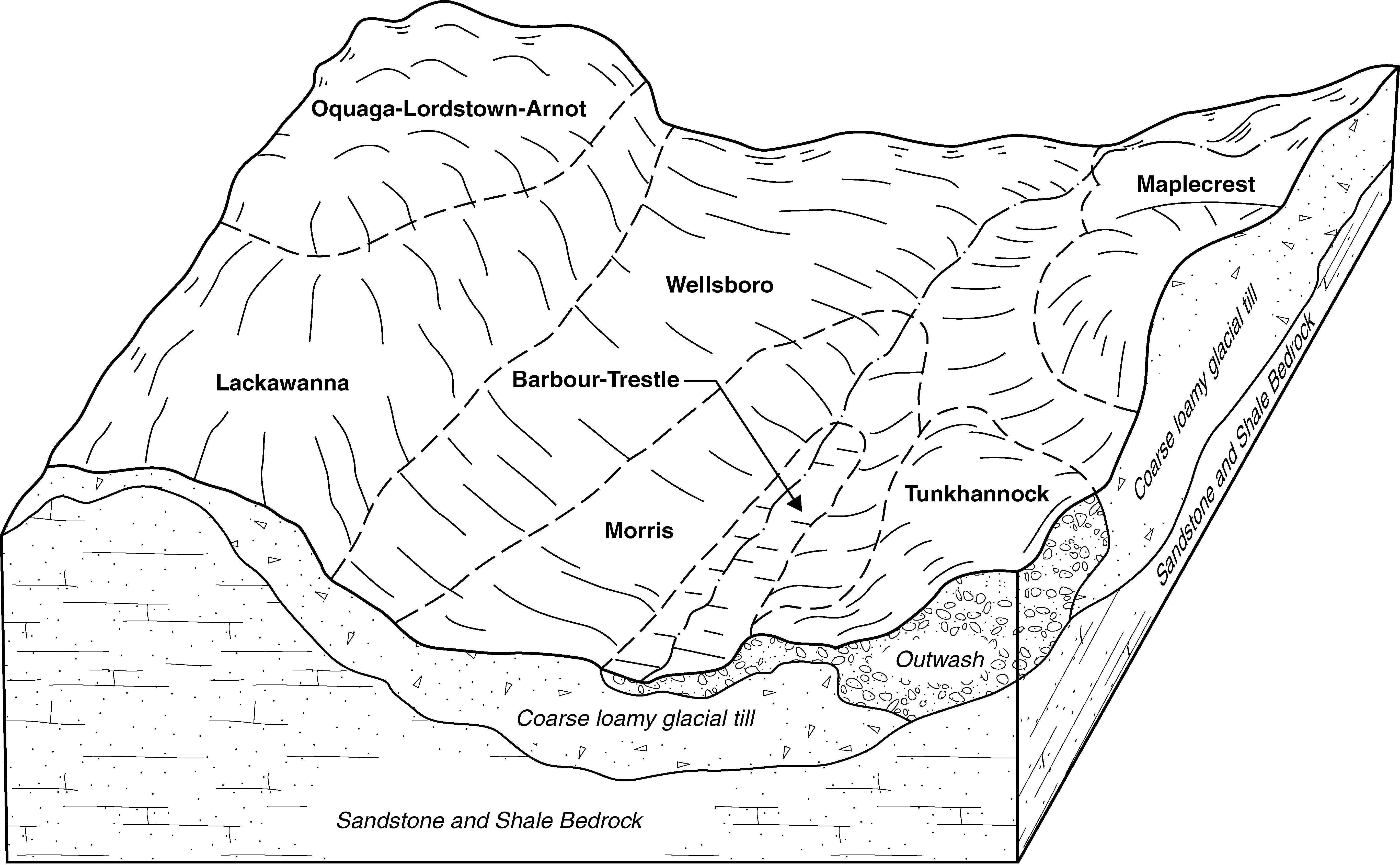
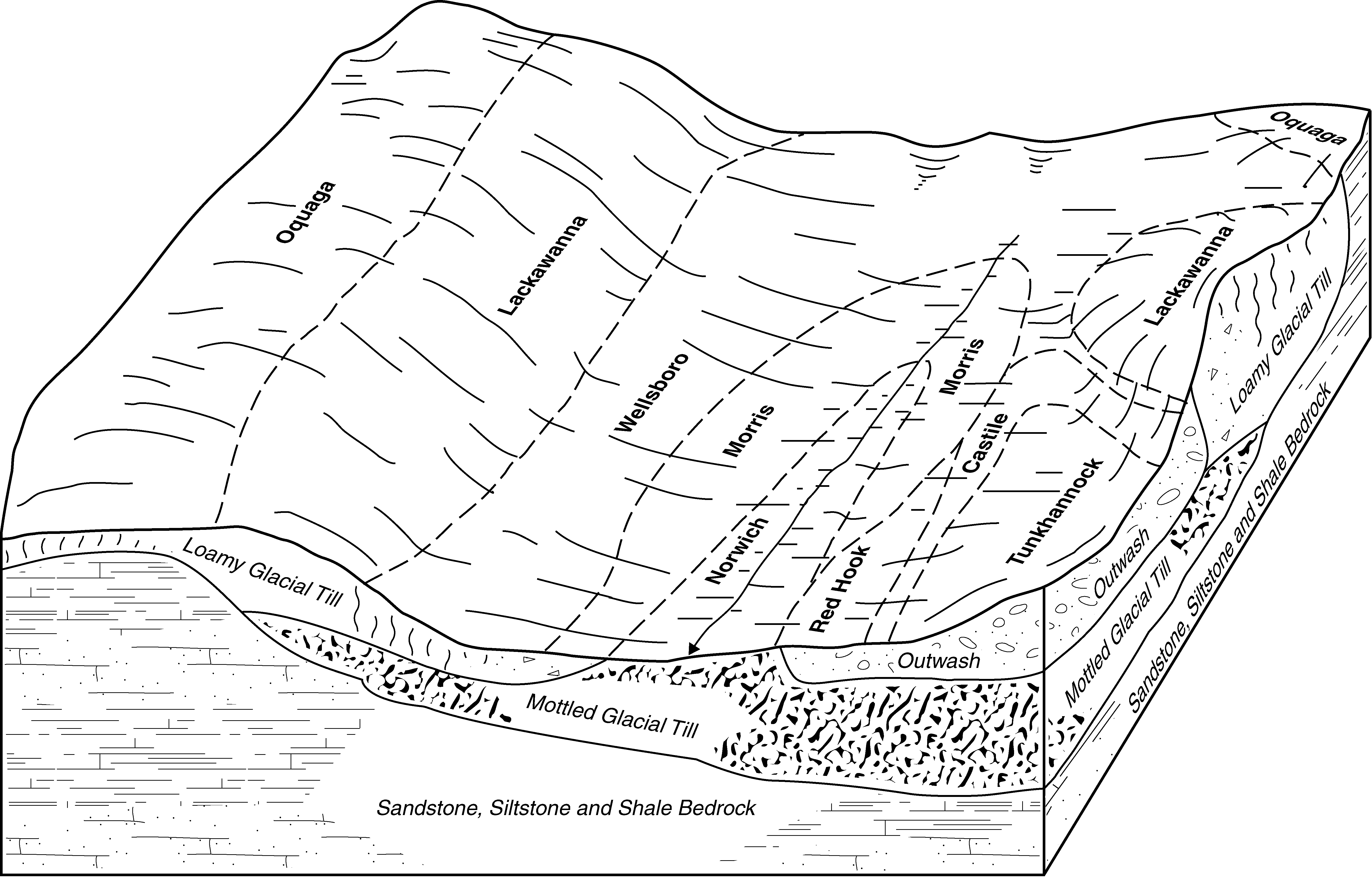
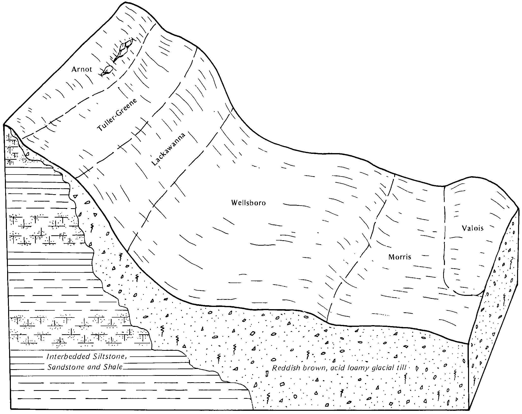
Morris and Tuller soils, 3 to 25 percent slopes, very stony | MuD | 962 | 289203 | 2vxcs | ny007 | 1966 | 1:15840 |
Volusia and Morris channery silt loams, 3 to 10 percent slopes, very stony | VpB | 24220 | 290054 | 2srfp | ny017 | 1982 | 1:15840 |
Morris channery silt loam, 3 to 8 percent slopes | MoB | 6420 | 290020 | 2vclt | ny017 | 1982 | 1:15840 |
Morris channery silt loam, 8 to 15 percent slopes | MoC | 2240 | 290021 | 2vclv | ny017 | 1982 | 1:15840 |
Morris channery silt loam, 0 to 3 percent slopes | MoA | 513 | 290019 | 2vclp | ny017 | 1982 | 1:15840 |
Morris and Volusia soils, 2 to 10 percent slopes, very stony | MsB | 5222 | 290525 | 2srfq | ny025 | 1999 | 1:24000 |
Morris flaggy silt loam, 3 to 8 percent slopes | MrB | 4519 | 290523 | 2vcm6 | ny025 | 1999 | 1:24000 |
Morris flaggy silt loam, 8 to 15 percent slopes | MrC | 4174 | 290524 | 2vcm7 | ny025 | 1999 | 1:24000 |
Lackawanna-Morris complex, 15 to 35 percent slopes, very stony | LcD | 1892 | 290494 | 2vxcr | ny025 | 1999 | 1:24000 |
Morris flaggy silt loam, 0 to 3 percent slopes | MrA | 561 | 290522 | 2vcm5 | ny025 | 1999 | 1:24000 |
Morris channery silt loam, 3 to 8 percent slopes | MoB | 1003 | 291681 | 2vclt | ny039 | 1985 | 1:24000 |
Morris channery silt loam, 3 to 15 percent slopes, very stony | MpC | 468 | 291683 | 2vcmc | ny039 | 1985 | 1:24000 |
Morris channery silt loam, 8 to 15 percent slopes | MoC | 227 | 291682 | 2vclv | ny039 | 1985 | 1:24000 |
Morris channery silt loam, 0 to 3 percent slopes | MoA | 217 | 291680 | 2vclp | ny039 | 1985 | 1:24000 |
Morris channery silt loam, 2 to 8 percent slopes | MoB | 3400 | 294257 | 2vcls | ny077 | 1993 | 1:24000 |
Morris and Volusia soils, 3 to 15 percent slopes, extremely stony | MpC | 2989 | 294259 | 2srfv | ny077 | 1993 | 1:24000 |
Morris channery silt loam, 8 to 15 percent slopes | MoC | 1625 | 294258 | 2vclv | ny077 | 1993 | 1:24000 |
Volusia, Morris, and Erie soils, 0 to 15 percent slopes, very stony | VmC | 14682 | 294566 | 2srfs | ny095 | 1965 | 1:15840 |
Morris stony silt loam, 2 to 8 percent slopes | MoB | 2563 | 294518 | 2vcm9 | ny095 | 1965 | 1:15840 |
Morris stony silt loam, 8 to 15 percent slopes | MoC | 980 | 294519 | 2vcmb | ny095 | 1965 | 1:15840 |
Morris channery silt loam, gently sloping, extremely stony | MSB | 4555 | 294842 | 2vxd1 | ny101 | 1972 | 1:15840 |
Morris channery silt loam, 2 to 8 percent slopes | MrB | 4401 | 294840 | 2vcls | ny101 | 1972 | 1:15840 |
Morris channery silt loam, 8 to 15 percent slopes | MrC | 2343 | 294841 | 2vclv | ny101 | 1972 | 1:15840 |
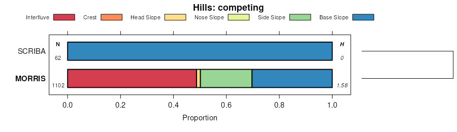
Scriba and Morris loams, gently sloping, rubbly | SeB | 9719 | 295125 | 2vxdt | ny105 | 1984 | 1:15840 |
Morris loam, 3 to 8 percent slopes | MrB | 7098 | 295093 | 2vxdj | ny105 | 1984 | 1:15840 |
Morris loam, 0 to 3 percent slopes | MrA | 3060 | 295092 | 2vxdh | ny105 | 1984 | 1:15840 |
Morris loam, 8 to 15 percent slopes | MrC | 1274 | 295094 | 2vxdk | ny105 | 1984 | 1:15840 |
Scriba and Morris soils, gently sloping, very bouldery | SEB | 9407 | 295540 | 2vxd3 | ny111 | 1974 | 1:15840 |
Morris-Tuller complex, gently sloping, very bouldery | MTB | 3862 | 295506 | 2vxd2 | ny111 | 1974 | 1:15840 |
Scriba and Morris soils, gently sloping, extremely bouldery | SGB | 2865 | 295541 | 2vxd4 | ny111 | 1974 | 1:15840 |
Scriba and Morris soils, 0 to 8 percent slopes | SdB | 494 | 295539 | 2vcm8 | ny111 | 1974 | 1:15840 |
Morris channery silt loam, 0 to 8 percent slopes, extremely stony | MrB | 1499 | 539392 | 2vxct | pa025 | 1960 | 1:20000 |
Morris channery silt loam, 3 to 8 percent slopes | MrB | 234 | 539538 | l3fg | pa037 | 1965 | 1:20000 |
Morris very stony silt loam, 0 to 8 percent slopes | MsB | 226 | 539539 | l3fh | pa037 | 1965 | 1:20000 |
Morris channery loam, 3 to 8 percent slopes | MrB | 11592 | 299314 | 2vxdf | pa069 | 1976 | 1:20000 |
Morris channery loam, 0 to 8 percent slopes, rubbly | MxB | 9375 | 299318 | 2vxdq | pa069 | 1976 | 1:20000 |
Morris channery loam, 8 to 15 percent slopes | MrC | 4889 | 299315 | 2vxdg | pa069 | 1976 | 1:20000 |
Morris flaggy loam, 3 to 8 percent slopes | MsB | 3208 | 299316 | 2vxdl | pa069 | 1976 | 1:20000 |
Morris channery loam, 8 to 25 percent slopes, rubbly | MxD | 2228 | 299319 | 2vxds | pa069 | 1976 | 1:20000 |
Morris flaggy loam, 8 to 15 percent slopes | MsC | 1552 | 299317 | 2vxdm | pa069 | 1976 | 1:20000 |
Morris channery loam, 0 to 3 percent slopes | MrA | 1425 | 299313 | 2vxdd | pa069 | 1976 | 1:20000 |
Morris channery silt loam, 0 to 8 percent slopes, extremely stony | MsB | 16427 | 296464 | 2vxct | pa079 | 1974 | 1:20000 |
Morris channery silt loam, 0 to 8 percent slopes | MoB | 7332 | 296462 | 2vclq | pa079 | 1974 | 1:20000 |
Morris channery silt loam, 8 to 15 percent slopes | MoC | 1410 | 296463 | 2vclv | pa079 | 1974 | 1:20000 |
Morris channery silt loam, 8 to 15 percent slopes, extremely stony | MsC | 1198 | 296465 | 2vxcx | pa079 | 1974 | 1:20000 |
Morris channery silt loam, 0 to 8 percent slopes, extremely stony | MrB | 5376 | 539102 | 2vxct | pa081 | 1981 | 1:20000 |
Morris channery silt loam, 3 to 8 percent slopes | MoB | 2570 | 539100 | 2vclt | pa081 | 1981 | 1:20000 |
Morris channery silt loam, 8 to 15 percent slopes | MoC | 650 | 539101 | 2vclv | pa081 | 1981 | 1:20000 |
Morris channery silt loam, 0 to 8 percent slopes, extremely stony | MoB | 14030 | 296339 | 2vxct | pa089 | 1975 | 1:20000 |
Morris channery silt loam, 2 to 10 percent slopes | MgB | 1359 | 296338 | 2vclr | pa089 | 1975 | 1:20000 |
Morris channery silt loam, 8 to 25 percent slopes, extremely stony | MoC | 864 | 296340 | 2vxcy | pa089 | 1975 | 1:20000 |
Morris very channery loam, 0 to 8 percent slopes, very stony | 19B | 7784 | 297194 | 2vxdn | pa103 | 1995 | 1:24000 |
Morris very channery loam, 8 to 15 percent slopes, very stony | 19C | 733 | 297195 | 2vxdp | pa103 | 1995 | 1:24000 |
Morris and Volusia soils, 8 to 25 percent slopes, very stony | MrsD | 1116 | 2944239 | 2wbnv | pa105 | 2007 | 1:24000 |
Morris silt loam, 8 to 15 percent slopes | MrC | 1014 | 2433168 | 2vcm4 | pa105 | 2007 | 1:24000 |
Morris silt loam, 3 to 8 percent slopes | MrB | 622 | 2433167 | 2vcm3 | pa105 | 2007 | 1:24000 |
Morris silt loam, 15 to 25 percent slopes | MrD | 262 | 1883573 | 2vxd0 | pa105 | 2007 | 1:24000 |
Morris and Volusia soils, 0 to 8 percent slopes, very stony | MrsB | 150 | 2944238 | 2wbnt | pa105 | 2007 | 1:24000 |
Morris channery silt loam, 3 to 8 percent slopes, eroded | MoB2 | 21534 | 297065 | 2vxd5 | pa115 | 1968 | 1:20000 |
Morris flaggy silt loam, 3 to 8 percent slopes, eroded | MrB2 | 13452 | 297067 | 2vxd7 | pa115 | 1968 | 1:20000 |
Morris channery silt loam, 8 to 15 percent slopes, eroded | MoC2 | 12944 | 297066 | 2vxd6 | pa115 | 1968 | 1:20000 |
Morris channery silt loam, 0 to 8 percent slopes, extremely stony | MsB | 8325 | 297070 | 2vxct | pa115 | 1968 | 1:20000 |
Morris flaggy silt loam, 8 to 15 percent slopes, eroded | MrC2 | 7943 | 297068 | 2vxdb | pa115 | 1968 | 1:20000 |
Morris channery silt loam, 8 to 25 percent slopes, extremely stony | MsD | 5085 | 297071 | 2vxcy | pa115 | 1968 | 1:20000 |
Morris channery silt loam, 0 to 3 percent slopes | MoA | 2112 | 297064 | 2vclp | pa115 | 1968 | 1:20000 |
Morris flaggy silt loam, 15 to 25 percent slopes, eroded | MrD2 | 767 | 297069 | 2vxdc | pa115 | 1968 | 1:20000 |
Morris gravelly silt loam, 8 to 15 percent slopes | MoC | 16527 | 297138 | 2vcly | pa117 | 1973 | 1:20000 |
Morris gravelly silt loam, 3 to 8 percent slopes | MoB | 14842 | 297137 | 2vclx | pa117 | 1973 | 1:20000 |
Morris gravelly silt loam, 8 to 25 percent slopes, extremely stony | MsD | 3661 | 297141 | 2vcm1 | pa117 | 1973 | 1:20000 |
Morris gravelly silt loam, 0 to 8 percent slopes, extremely stony | MsB | 3418 | 297140 | 2vcm0 | pa117 | 1973 | 1:20000 |
Morris gravelly silt loam, 15 to 25 percent slopes | MoD | 2577 | 297139 | 2vclz | pa117 | 1973 | 1:20000 |
Morris gravelly silt loam, 0 to 3 percent slopes | MoA | 2235 | 297136 | 2vclw | pa117 | 1973 | 1:20000 |
Morris channery loam, 0 to 8 percent slopes, rubbly | MxB | 39992 | 296610 | 2vxdq | pa127 | 1977 | 1:20000 |
Morris channery loam, 3 to 8 percent slopes | MoB | 19976 | 296608 | 2vxdf | pa127 | 1977 | 1:20000 |
Morris channery loam, 8 to 15 percent slopes, rubbly | MxC | 11150 | 296611 | 2vxdr | pa127 | 1977 | 1:20000 |
Morris channery loam, 8 to 15 percent slopes | MoC | 5875 | 296609 | 2vxdg | pa127 | 1977 | 1:20000 |
Morris channery loam, 0 to 3 percent slopes | MoA | 1030 | 296607 | 2vxdd | pa127 | 1977 | 1:20000 |
Morris channery loam, 0 to 8 percent slopes, rubbly | MxB | 7394 | 301947 | 2vxdq | pa131 | 1976 | 1:20000 |
Morris channery loam, 3 to 8 percent slopes | MrB | 5243 | 301943 | 2vxdf | pa131 | 1976 | 1:20000 |
Morris channery loam, 8 to 15 percent slopes | MrC | 4647 | 301944 | 2vxdg | pa131 | 1976 | 1:20000 |
Morris flaggy loam, 3 to 8 percent slopes | MsB | 2762 | 301945 | 2vxdl | pa131 | 1976 | 1:20000 |
Morris channery loam, 8 to 25 percent slopes, rubbly | MxD | 1063 | 301948 | 2vxds | pa131 | 1976 | 1:20000 |
Morris flaggy loam, 8 to 15 percent slopes | MsC | 1035 | 301946 | 2vxdm | pa131 | 1976 | 1:20000 |
Morris channery loam, 0 to 3 percent slopes | MrA | 463 | 301942 | 2vxdd | pa131 | 1976 | 1:20000 |
Morris channery silt loam, 3 to 8 percent slopes, extremely stony | MsB | 41771 | 296770 | 2vxcw | pa610 | 1978 | 1:20000 |
Morris channery silt loam, 3 to 8 percent slopes | MoB | 41719 | 296768 | 2vclt | pa610 | 1978 | 1:20000 |
Morris channery silt loam, 8 to 15 percent slopes | MoC | 41679 | 296769 | 2vclv | pa610 | 1978 | 1:20000 |
Morris channery silt loam, 8 to 25 percent slopes, extremely stony | MsD | 23026 | 296771 | 2vxcy | pa610 | 1978 | 1:20000 |