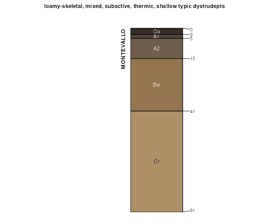
| Montevallo-Townley complex, 15 to 35 percent slopes | MwF | 235 | 2233027 | 2dyn4 | al007 | 2007 | 1:24000 |
Montevallo-Townley complex, 15 to 45 percent slopes | MtF | 48409 | 328387 | 2s8ml | al009 | 1974 | 1:24000 |
Montevallo-Townley complex, 6 to 15 percent slopes | MtD | 1891 | 328386 | 2s8mq | al009 | 1974 | 1:24000 |
Montevallo shaly silt loam, 10 to 15 percent slopes | MsD | 9595 | 523361 | kklm | al015 | 1959 | 1:20000 |
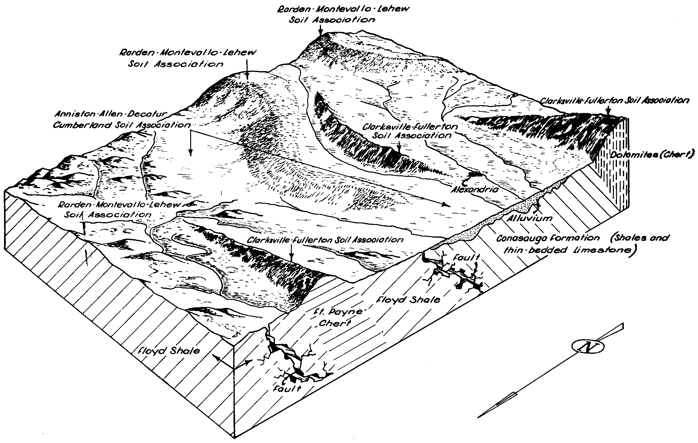
Rarden-Montevallo complex, 2 to 10 percent slopes, eroded | RmC2 | 5114 | 523381 | kkm8 | al015 | 1959 | 1:20000 |
Montevallo shaly silty clay loam, 10 to 40 percent slopes, severely eroded | MtD3 | 5028 | 523364 | kklq | al015 | 1959 | 1:20000 |
Montevallo shaly silt loam, 15 to 40 percent slopes | MsE | 4795 | 523362 | kkln | al015 | 1959 | 1:20000 |
Lehew-montevallo soils, 15 to 30 percent slopes | LhE | 4074 | 523347 | kkl5 | al015 | 1959 | 1:20000 |
Montevallo shaly silty clay loam, 6 to 10 percent slopes, severely eroded | MtC3 | 2072 | 523363 | kklp | al015 | 1959 | 1:20000 |
Lehew-montevallo soils, 10 to 15 percent slopes, eroded | LhD2 | 1965 | 523346 | kkl4 | al015 | 1959 | 1:20000 |
Lehew-montevallo soils, 2 to 10 percent slopes, eroded | LhC2 | 1281 | 523345 | kkl3 | al015 | 1959 | 1:20000 |
Firestone-Montevallo association, steep | FD | 12946 | 523002 | kk71 | al019 | 1973 | 1:20000 |
Firestone-Montevallo-Leesburg association, steep | FE | 10384 | 523003 | kk72 | al019 | 1973 | 1:20000 |
Montevallo-Herndon association, steep | MF | 3538 | 523020 | kk7m | al019 | 1973 | 1:20000 |
Townley-Montevallo complex, 15 to 40 percent slopes | TxE | 1710 | 1895743 | 21mp0 | al037 | 2006 | 1:24000 |
Montevallo channery silt loam, 15 to 50 percent slopes | MoE | 71210 | 329476 | 2sr72 | al057 | 1963 | 1:15840 |
Montevallo channery silt loam, 10 to 15 percent slopes | MoD | 1734 | 329474 | 2sr70 | al057 | 1963 | 1:15840 |
Montevallo channery silt loam, 10 to 15 percent slopes, severely eroded | MoD3 | 1305 | 329475 | 2sr71 | al057 | 1963 | 1:15840 |
Montevallo channery silt loam, 15 to 50 percent slopes, severely eroded | MoE3 | 1250 | 329477 | 2sr73 | al057 | 1963 | 1:15840 |
Montevallo channery silt loam, 6 to 10 percent slopes, severely eroded | MoC3 | 1141 | 329473 | 2sr75 | al057 | 1963 | 1:15840 |
Montevallo channery silt loam, 6 to 10 percent slopes | MoC | 1028 | 329472 | 2sr74 | al057 | 1963 | 1:15840 |
Montevallo-Nauvoo association, 6 to 45 percent slopes | 29 | 264300 | 329927 | 2s8mt | al073 | 1980 | 1:24000 |
Nauvoo-Montevallo association, 10 to 40 percent slopes | 34 | 47380 | 329933 | 2s8mn | al073 | 1980 | 1:24000 |
Montevallo-Nauvoo-Urban land complex, 10 to 40 percent slopes | 28 | 6820 | 329926 | 2s8mv | al073 | 1980 | 1:24000 |
Montevallo shaly silt loam, severely eroded, steep | MgF3 | 466 | 330733 | c34t | al095 | 1956 | 1:20000 |
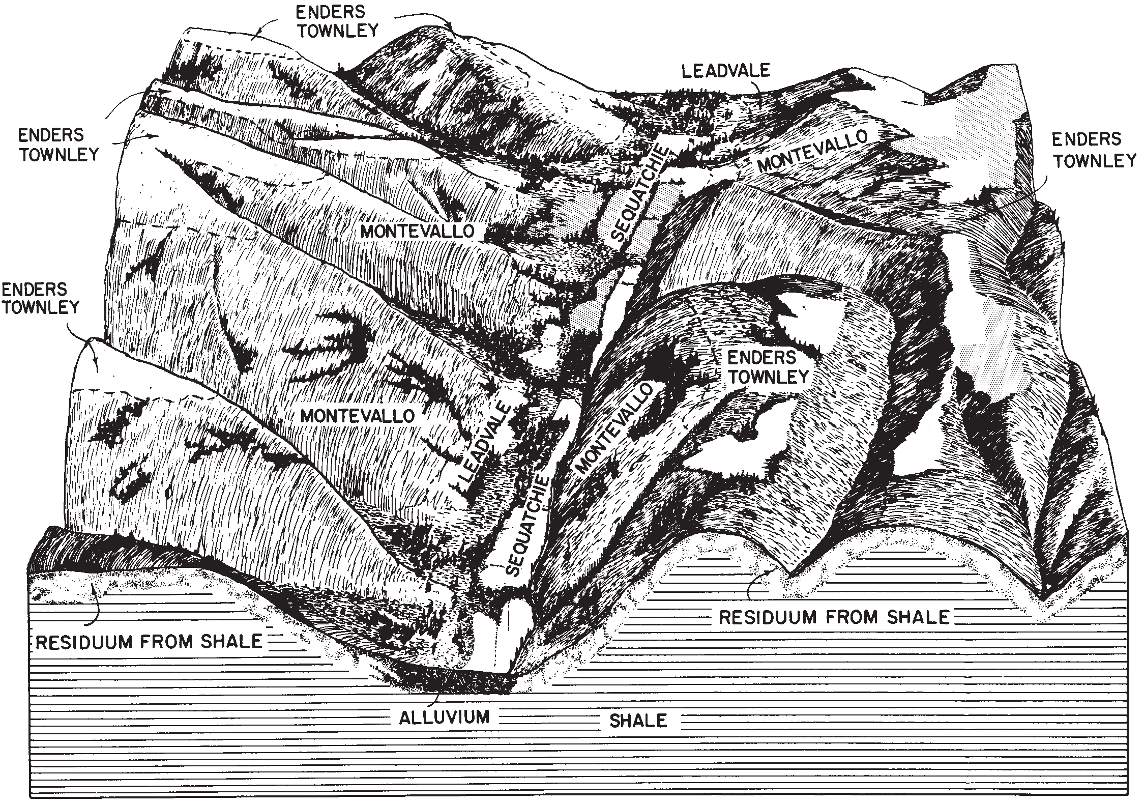
Enders-Montevallo association, steep | EmE | 3356 | 523234 | kkgj | al121 | 1969 | 1:20000 |
Enders-Townley-Montevallo complex, 6 to 15 percent slopes | EtD | 1432 | 523235 | kkgk | al121 | 1969 | 1:20000 |
Montevallo-Nauvoo association, 10 to 45 percent slopes | 22 | 167711 | 331515 | 2s8mm | al125 | 1980 | 1:20000 |
Montevallo-Nauvoo complex, 15 to 45 percent slopes | 21 | 30997 | 331514 | 2s8mp | al125 | 1980 | 1:20000 |
Montevallo channery silt loam, 30 to 60 percent slopes | McE | 54339 | 331547 | 2s8mk | al127 | 1986 | 1:24000 |
Montevallo-Mountainburg complex, 12 to 40 percent slopes | MmE | 9646 | 565572 | lzj8 | ar047 | 1967 | 1:20000 |
Montevallo-Mountainburg complex, 1 to 12 percent slopes | MmD | 4408 | 565571 | lzj7 | ar047 | 1967 | 1:20000 |
Montevallo gravelly silt loam, 3 to 8 percent slopes | MlC | 1714 | 565570 | lzj6 | ar047 | 1967 | 1:20000 |
Montevallo gravelly loam, 3 to 12 percent slopes | MlD | 2716 | 566384 | m0cg | ar131 | 1971 | 1:20000 |
Montevallo soils, 3 to 12 percent slopes | MoD | 1862 | 566602 | m0lh | ar143 | 1966 | 1:20000 |
Montevallo soils, 12 to 25 percent slopes | MoE | 271 | 566603 | m0lj | ar143 | 1966 | 1:20000 |
Montevallo channery silt loam, 30 to 45 percent slopes | MvF | 6648 | 1611805 | 1r36q | ga015 | 2013 | 1:12000 |
Montevallo channery silt loam, 15 to 30 percent slopes | MvE | 4482 | 1611803 | 1r36n | ga015 | 2013 | 1:12000 |
Townley-Montevallo complex, 15 to 30 percent slopes | TvE | 4326 | 1611879 | 1r393 | ga015 | 2013 | 1:12000 |
Montevallo channery silt loam, 10 to 15 percent slopes | MvD | 3519 | 884434 | ypb4 | ga015 | 2013 | 1:12000 |
Townley-Montevallo complex, 10 to 15 percent slopes | TvD | 3397 | 884415 | yp9j | ga015 | 2013 | 1:12000 |
Montevallo channery silt loam, 6 to 10 percent slopes | MvC | 1024 | 884432 | ypb2 | ga015 | 2013 | 1:12000 |
Townley-Montevallo complex, 30 to 45 percent slopes | TvF | 413 | 1611880 | 1r394 | ga015 | 2013 | 1:12000 |
Townley-Urban land-Montevallo complex, 0 to 15 percent slopes | TxD | 310 | 2554245 | 2qvq1 | ga015 | 2013 | 1:12000 |
Montevallo-Townley-Urban land complex, 15 to 30 percent slopes | MxE | 67 | 2554241 | 2qvpx | ga015 | 2013 | 1:12000 |
Montevallo-Townley complex, 15 to 30 percent slopes | MtE | 19485 | 2023822 | 25xyl | ga129 | 2007 | 1:12000 |
Montevallo very channery loam, 30 to 70 percent slopes | MoF | 16400 | 2023823 | 25xym | ga129 | 2007 | 1:12000 |
Townley-Montevallo complex, 6 to 15 percent slopes | TmD | 13765 | 2023821 | 25xyk | ga129 | 2007 | 1:12000 |
Montevallo-Urban land complex, 10 to 25 percent slopes | MuE | 10 | 2023853 | 25xzl | ga129 | 2007 | 1:12000 |
Montevallo channery silt loam, 15 to 55 percent slopes | MoE | 18639 | 2480319 | 2p7z9 | ga619 | 2012 | 1:24000 |
Townley-Montevallo complex, 15 to 45 percent slopes | TnF | 8339 | 2480329 | 2p7zm | ga619 | 2012 | 1:24000 |
Townley-Montevallo complex, 10 to 15 percent slopes | TnD | 5024 | 2480328 | 2p7zl | ga619 | 2012 | 1:24000 |
Townley-Montevallo complex, 2 to 10 percent slopes | TnC | 4503 | 2480327 | 2p7zk | ga619 | 2012 | 1:24000 |
Montevallo channery silt loam, 6 to 15 percent slopes | MoD | 1711 | 2480318 | 2p7z8 | ga619 | 2012 | 1:24000 |
Montevallo very shaly silt loam, 15 to 45 percent slopes | MsF | 28920 | 531287 | ktv9 | ga621 | 1975 | 1:20000 |
Montevallo very shaly silt loam, 6 to 15 percent slopes | MsD | 7360 | 531286 | ktv8 | ga621 | 1975 | 1:20000 |
Montevallo-Townley complex, 6 to 15 percent slopes | MtD | 35905 | 562861 | lwpt | ga648 | 2001 | 1:12000 |
Montevallo-Townley complex, 15 to 30 percent slopes | MtE | 25200 | 562863 | 2wml0 | ga648 | 2001 | 1:12000 |
Montevallo very channery loam, 30 to 60 percent slopes | MoF | 11680 | 562864 | lwpx | ga648 | 2001 | 1:12000 |
Montevallo-Urban land complex, 10 to 25 percent slopes | MuE | 460 | 562943 | lwsg | ga648 | 2001 | 1:12000 |
Armuchee-Montevallo complex, 25 to 60 percent slopes | ApE | 12671 | 1887433 | 21c0y | tn001 | 1978 | 1:15840 |
Montevallo channery silt loam, 20 to 35 percent slopes | MvE | 10556 | 1887411 | 301hk | tn001 | 1978 | 1:15840 |
Montevallo channery silt loam, 12 to 20 percent slopes | MvD | 3132 | 1887410 | 301hj | tn001 | 1978 | 1:15840 |
Montevallo channery silt loam, 5 to 12 percent slopes | MvC | 348 | 1887409 | 2t3gr | tn001 | 1978 | 1:15840 |
Montevallo shaly silt loam, eroded rolling phase | Mo | 11893 | 526953 | kpbh | tn011 | 1951 | 1:20000 |
Lehew-Montevallo loams, steep phases | Lk | 7199 | 526934 | kp9w | tn011 | 1951 | 1:20000 |
Montevallo shaly silt loam, eroded hilly phase | Mn | 6010 | 526952 | kpbg | tn011 | 1951 | 1:20000 |
Montevallo shaly silt loam, hilly phase | Mr | 5563 | 526955 | kpbk | tn011 | 1951 | 1:20000 |
Montevallo channery silt loam, 5 to 12 percent slopes | Ms | 4928 | 526956 | 2t3gr | tn011 | 1951 | 1:20000 |
Montevallo and Muskingum soils, steep phases | Mm | 4691 | 526951 | kpbf | tn011 | 1951 | 1:20000 |
Lehew-Montevallo loams, rolling phases | Lh | 1890 | 526933 | kp9v | tn011 | 1951 | 1:20000 |
Lehew-Montevallo loams, hilly phases | Lg | 1755 | 526932 | kp9t | tn011 | 1951 | 1:20000 |
Lehew-Montevallo loams, eroded hilly phases | Ld | 1491 | 526929 | kp9q | tn011 | 1951 | 1:20000 |
Lehew-Montevallo loams, eroded steep phases | Lf | 1006 | 526931 | kp9s | tn011 | 1951 | 1:20000 |
Lehew-Montevallo loams, eroded rolling phases | Le | 894 | 526930 | kp9r | tn011 | 1951 | 1:20000 |
Montevallo and Muskingum soils, hilly phases | Mk | 815 | 526949 | kpbc | tn011 | 1951 | 1:20000 |
Montevallo shaly silt loam, eroded undulating phase | Mp | 813 | 526954 | kpbj | tn011 | 1951 | 1:20000 |
Montevallo and Muskingum soils, rolling phases | Ml | 788 | 526950 | kpbd | tn011 | 1951 | 1:20000 |
Montevallo channery silt loam, 50 to 80 percent slopes | MoG | 2633 | 526473 | 2t3gx | tn019 | 2000 | 1:24000 |
Montevallo channery silt loam, 35 to 50 percent slopes | MoF | 1752 | 526472 | 2t3gw | tn019 | 2000 | 1:24000 |
Montevallo channery silt loam, 20 to 35 percent slopes | MoE | 911 | 526471 | 301hk | tn019 | 2000 | 1:24000 |
Montevallo channery silt loam, 12 to 20 percent slopes | MoD | 585 | 526470 | 301hj | tn019 | 2000 | 1:24000 |
Montevallo shaly silt loam | Mv | 1682 | 524537 | kltk | tn025 | 1948 | 1:24000 |
Montevallo shaly silt loam, hilly phase | Mvl | 1216 | 524538 | kltl | tn025 | 1948 | 1:24000 |
Rough gullied land, Montevallo soil material | RgM | 372 | 524544 | klts | tn025 | 1948 | 1:24000 |
Townley-Montevallo complex, 35 to 60 percent slopes | TmF | 12627 | 525042 | kmbv | tn057 | 1996 | 1:24000 |
Townley-Montevallo complex, 20 to 35 percent slopes | TmE | 6784 | 525041 | kmbt | tn057 | 1996 | 1:24000 |
Townley-Montevallo complex, 12 to 20 percent slopes | TmD | 3979 | 525040 | kmbs | tn057 | 1996 | 1:24000 |
Montevallo channery silt loam, 35 to 65 percent slopes | MoF | 1688 | 525033 | kmbk | tn057 | 1996 | 1:24000 |
Montevallo channery silt loam, 20 to 35 percent slopes | MoE | 969 | 525032 | 301hk | tn057 | 1996 | 1:24000 |
Montevallo channery silt loam, 5 to 12 percent slopes | MoC | 904 | 525030 | 2t3gr | tn057 | 1996 | 1:24000 |
Montevallo channery silt loam, 12 to 20 percent slopes | MoD | 790 | 525031 | 301hj | tn057 | 1996 | 1:24000 |
Montevallo shaly silt loam, 20 to 45 percent slopes | MoE | 4276 | 1017873 | 1355m | tn065 | 1980 | 1:15840 |
Montevallo channery silt loam, 2 to 10 percent slopes | MoC | 955 | 525485 | kmt4 | tn089 | 1991 | 1:24000 |
Montevallo-Armuchee complex, 15 to 50 percent slopes, gullied | MpE | 769 | 525487 | kmt6 | tn089 | 1991 | 1:24000 |
Montevallo channery silt loam, 10 to 20 percent slopes | MoD | 449 | 525486 | kmt5 | tn089 | 1991 | 1:24000 |
Apison-Montevallo complex, 35 to 75 percent slopes, rocky | AmF | 11882 | 632889 | p7ks | tn093 | 2005 | 1:12000 |
Apison-Montevallo complex, 25 to 35 percent slopes, rocky | AmE | 5383 | 632888 | p7kr | tn093 | 2005 | 1:12000 |
Apison-Montevallo complex, 12 to 25 percent slopes | AmD | 4425 | 632887 | p7kq | tn093 | 2005 | 1:12000 |
Apison-Montevallo complex, 5 to 12 percent slopes | AmC | 2359 | 632886 | p7kp | tn093 | 2005 | 1:12000 |
Townley-Montevallo complex, 35 to 60 percent slopes | TvF | 526 | 632885 | p7kn | tn093 | 2005 | 1:12000 |
Townley-Montevallo complex, 12 to 20 percent slopes | TvD | 205 | 632883 | p7kl | tn093 | 2005 | 1:12000 |
Townley-Montevallo complex, 20 to 35 percent slopes | TvE | 181 | 632884 | p7km | tn093 | 2005 | 1:12000 |
Montevallo channery silt loam, 5 to 20 percent slopes | MtD | 1760 | 1539922 | 1npdx | tn121 | 1968 | 1:15840 |
Montevallo channery silt loam, 20 to 35 percent slopes | MtE | 406 | 1539923 | 301hk | tn121 | 1968 | 1:15840 |
Montevallo shaly silt loam, 12 to 30 percent slopes | MtE | 1309 | 527917 | kqbl | tn123 | 1974 | 1:20000 |
Montevallo channery silt loam, 20 to 35 percent slopes | MoE | 27598 | 818240 | 301hk | tn145 | 2005 | 1:24000 |
Montevallo channery silt loam, 12 to 20 percent slopes | MoD | 9085 | 818239 | 301hj | tn145 | 2005 | 1:24000 |
Montevallo channery silt loam, 5 to 12 percent slopes | MoC | 5610 | 818238 | 2t3gr | tn145 | 2005 | 1:24000 |
Montevallo channery silt loam, 50 to 80 percent slopes | MoG | 28862 | 530085 | 2t3gx | tn163 | 1991 | 1:20000 |
Montevallo channery silt loam, 35 to 50 percent slopes | MoF | 13440 | 530084 | 2t3gw | tn163 | 1991 | 1:20000 |
Montevallo channery silt loam, 20 to 35 percent slopes | MoE | 7307 | 530083 | 301hk | tn163 | 1991 | 1:20000 |
Montevallo channery silt loam, 12 to 20 percent slopes | MoD | 7005 | 530082 | 301hj | tn163 | 1991 | 1:20000 |
Montevallo shaly silt loam, steep phase | Mvz | 5065 | 529987 | kshc | tn173 | 1945 | 1:24000 |
Rough gullied land, Montevallo soil material | RgM | 1467 | 529992 | kshj | tn173 | 1945 | 1:24000 |
Montevallo shaly silt loam, rolling phase | Mvo | 894 | 529986 | kshb | tn173 | 1945 | 1:24000 |
Montevallo channery silt loam, 35 to 50 percent slopes | MoF | 4485 | 1689690 | 2t3gw | tn179 | 1955 | 1:15840 |
Montevallo channery silt loam, 50 to 80 percent slopes | MoG | 4329 | 1689689 | 2t3gx | tn179 | 1955 | 1:15840 |
Montevallo channery silt loam, 12 to 20 percent slopes | MoD | 3705 | 1689692 | 301hj | tn179 | 1955 | 1:15840 |
Montevallo channery silt loam, 20 to 35 percent slopes | MoE | 1684 | 1689691 | 301hk | tn179 | 1955 | 1:15840 |
Montevallo channery silt loam, 5 to 12 percent slopes | MoC | 1036 | 1718639 | 2t3gr | tn179 | 1955 | 1:15840 |
Montevallo shaly silt loam, 25 to 50 percent slopes | MnE | 22078 | 528594 | kr1f | tn602 | 1973 | 1:15840 |
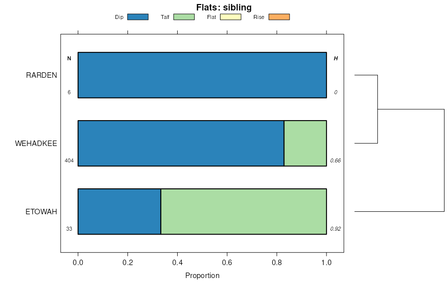
Montevallo-Talbott complex, 20 to 45 percent slopes | MoE | 6367 | 528595 | kr1g | tn602 | 1973 | 1:15840 |
Montevallo shaly silt loam, 8 to 25 percent slopes | MnD | 4551 | 528593 | kr1d | tn602 | 1973 | 1:15840 |
Montevallo channery silt loam, 12 to 25 percent slopes, eroded | MtD2 | 803 | 529697 | ks60 | tn608 | 2001 | 1:24000 |
Montevallo channery silt loam, 5 to 12 percent slopes, eroded | MtC2 | 451 | 529696 | ks5z | tn608 | 2001 | 1:24000 |
Montevallo shaly silt loam, steep phase | Me | 2479 | 1899536 | 21rmc | tn609 | 1955 | 1:20000 |
Montevallo shaly silt loam, moderately steep phase | Md | 905 | 1899535 | 21rmb | tn609 | 1955 | 1:20000 |