| Mongaup channery silt loam, 3 to 8 percent slopes | 79B | 9847 | 299985 | b24y | ny003 | 2013 | 1:24000 |
Mongaup channery silt loam, 15 to 25 percent slopes | 79D | 7762 | 299987 | b250 | ny003 | 2013 | 1:24000 |
Mongaup channery silt loam, 25 to 35 percent slopes | 79E | 7662 | 299988 | b251 | ny003 | 2013 | 1:24000 |
Mongaup channery silt loam, 8 to 15 percent slopes | 79C | 7613 | 299986 | b24z | ny003 | 2013 | 1:24000 |
Mongaup channery silt loam, 35 to 70 percent slopes | 79F | 4114 | 299989 | b252 | ny003 | 2013 | 1:24000 |
Mongaup and Ischua channery silt loams, 35 to 65 percent slopes, extremely stony | 71F | 3939 | 299965 | b249 | ny003 | 2013 | 1:24000 |
Mongaup and Ischua channery silt loams, 25 to 35 percent slopes, extremely stony | 71E | 2131 | 299964 | b248 | ny003 | 2013 | 1:24000 |
Mongaup and Ischua channery silt loams, 15 to 25 percent slopes, extremely stony | 71D | 770 | 299963 | b247 | ny003 | 2013 | 1:24000 |
Mongaup channery silt loam, 3 to 8 percent slopes, very stony | 71B | 62 | 299961 | b245 | ny003 | 2013 | 1:24000 |
Mongaup channery silt loam, 8 to 15 percent slopes, very stony | 71C | 61 | 299962 | b246 | ny003 | 2013 | 1:24000 |
Mongaup channery silt loam, 8 to 15 percent slopes | 79C | 2276 | 289709 | 9qgg | ny009 | 2002 | 1:24000 |
Mongaup channery silt loam, 15 to 25 percent slopes | 79D | 1843 | 289710 | 9qgh | ny009 | 2002 | 1:24000 |
Mongaup channery silt loam, 3 to 8 percent slopes | 79B | 1602 | 289708 | 9qgf | ny009 | 2002 | 1:24000 |
Mongaup channery silt loam, 35 to 70 percent slopes, very stony | 71F | 1360 | 289688 | 9qfs | ny009 | 2002 | 1:24000 |
Mongaup channery silt loam, 35 to 70 percent slopes | 79F | 1052 | 289712 | 9qgk | ny009 | 2002 | 1:24000 |
Mongaup channery silt loam, 25 to 35 percent slopes | 79E | 1004 | 289711 | 9qgj | ny009 | 2002 | 1:24000 |
Mongaup channery silt loam, 25 to 35 percent slopes, very stony | 71E | 883 | 289687 | 9qfr | ny009 | 2002 | 1:24000 |
Mongaup-Hawksnest complex, 3 to 8 percent slopes | 79B | 15091 | 2723057 | 2rwb7 | ny023 | 2014 | 1:12000 |
Mongaup channery silt loam, 15 to 25 percent slopes, very stony | 71D | 14493 | 2723058 | 2rwb8 | ny023 | 2014 | 1:12000 |
Mongaup channery silt loam, 8 to 15 percent slopes | 79C | 12053 | 2723059 | 2rwb9 | ny023 | 2014 | 1:12000 |
Rockrift-Mongaup complex, 25 to 70 percent slopes, very stony | 71F | 11488 | 2760841 | 2srh4 | ny023 | 2014 | 1:12000 |
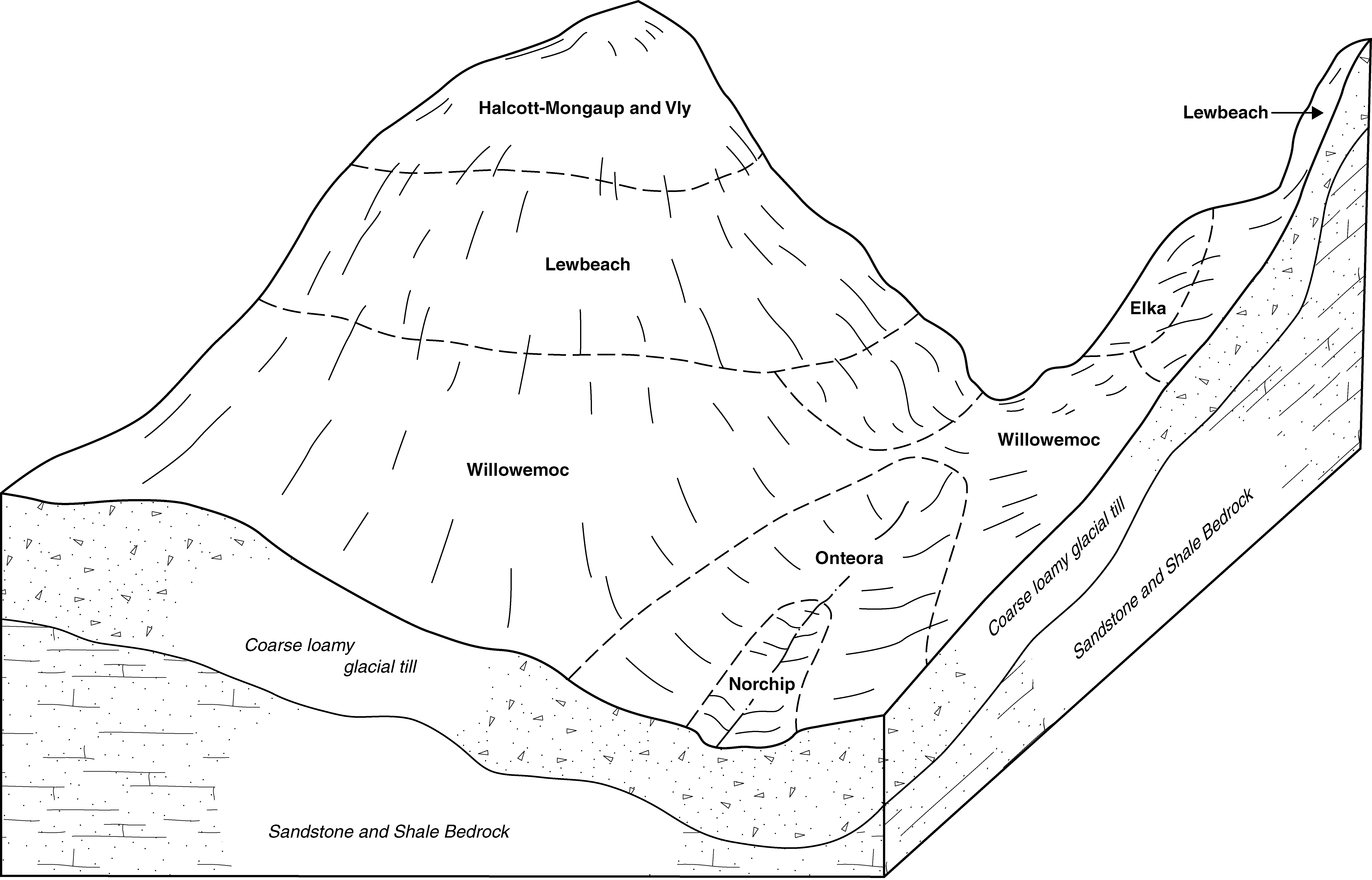
Halcott, Mongaup, and Vly soils, 15 to 35 percent slopes, very rocky | HcE | 86849 | 290485 | 9r8h | ny025 | 1999 | 1:24000 |
Halcott, Mongaup, and Vly soils, 35 to 70 percent slopes, very rocky | HcF | 63977 | 290486 | 9r8j | ny025 | 1999 | 1:24000 |
Halcott, Mongaup, and Vly soils, 2 to 15 percent slopes, very rocky | HcC | 47441 | 290484 | 9r8g | ny025 | 1999 | 1:24000 |
Mongaup channery loam, 8 to 15 percent slopes | MnC | 6796 | 290520 | 9r9m | ny025 | 1999 | 1:24000 |
Mongaup channery loam, 2 to 8 percent slopes | MnB | 3773 | 290519 | 9r9l | ny025 | 1999 | 1:24000 |
Mongaup channery loam, 15 to 25 percent slopes | MnD | 3657 | 290521 | 9r9n | ny025 | 1999 | 1:24000 |
Middlebrook-Mongaup complex, 2 to 8 percent slopes | MkB | 2602 | 290517 | 9r9j | ny025 | 1999 | 1:24000 |
Middlebrook-Mongaup complex, 8 to 15 percent slopes | MkC | 1622 | 290518 | 9r9k | ny025 | 1999 | 1:24000 |
Mongaup-Ischua complex, 15 to 25 percent slopes, very stony | 181D | 3091 | 3105766 | 2y9xy | ny051 | 2019 | 1:24000 |
Mongaup-Ischua complex, 25 to 35 percent slopes, extremely stony | 181E | 1491 | 3105767 | 2y9xz | ny051 | 2019 | 1:24000 |
Mongaup channery loam, 8 to 15 percent slopes | 181C | 545 | 3105765 | 2y9xx | ny051 | 2019 | 1:24000 |
Mongaup-Ischua complex, 35 to 70 percent slopes, extremely stony | 181F | 530 | 3105768 | 2y9y0 | ny051 | 2019 | 1:24000 |
Mongaup channery loam, 3 to 8 percent slopes | 181B | 138 | 3105764 | 2y9xw | ny051 | 2019 | 1:24000 |
Mongaup silt loam, 25 to 45 percent slopes | 173E | 2395 | 293360 | 9v87 | ny065 | 1993 | 1:24000 |
Mongaup silt loam, 8 to 15 percent slopes | 173C | 750 | 293359 | 9v86 | ny065 | 1993 | 1:24000 |
Mongaup silt loam, 3 to 8 percent slopes | 173B | 603 | 293358 | 9v85 | ny065 | 1993 | 1:24000 |
Mongaup-Ischua complex, 15 to 25 percent slopes, very stony | 181D | 3146 | 2504933 | 2pq3h | ny069 | 2012 | 1:12000 |
Mongaup-Ischua complex, 8 to 15 percent slopes | 181C | 2282 | 2504935 | 2pq3k | ny069 | 2012 | 1:12000 |
Mongaup-Ischua complex, 25 to 35 percent slopes, extremely stony | 181E | 1893 | 2512425 | 2q9m4 | ny069 | 2012 | 1:12000 |
Mongaup-Ischua complex, 3 to 8 percent slopes | 181B | 832 | 2504934 | 2pq3j | ny069 | 2012 | 1:12000 |
Mongaup channery loam, 3 to 8 percent slopes | 182B | 513 | 2504925 | 2q6bc | ny069 | 2012 | 1:12000 |
Mongaup channery loam, 8 to 15 percent slopes | 182C | 146 | 2504926 | 2q6bd | ny069 | 2012 | 1:12000 |
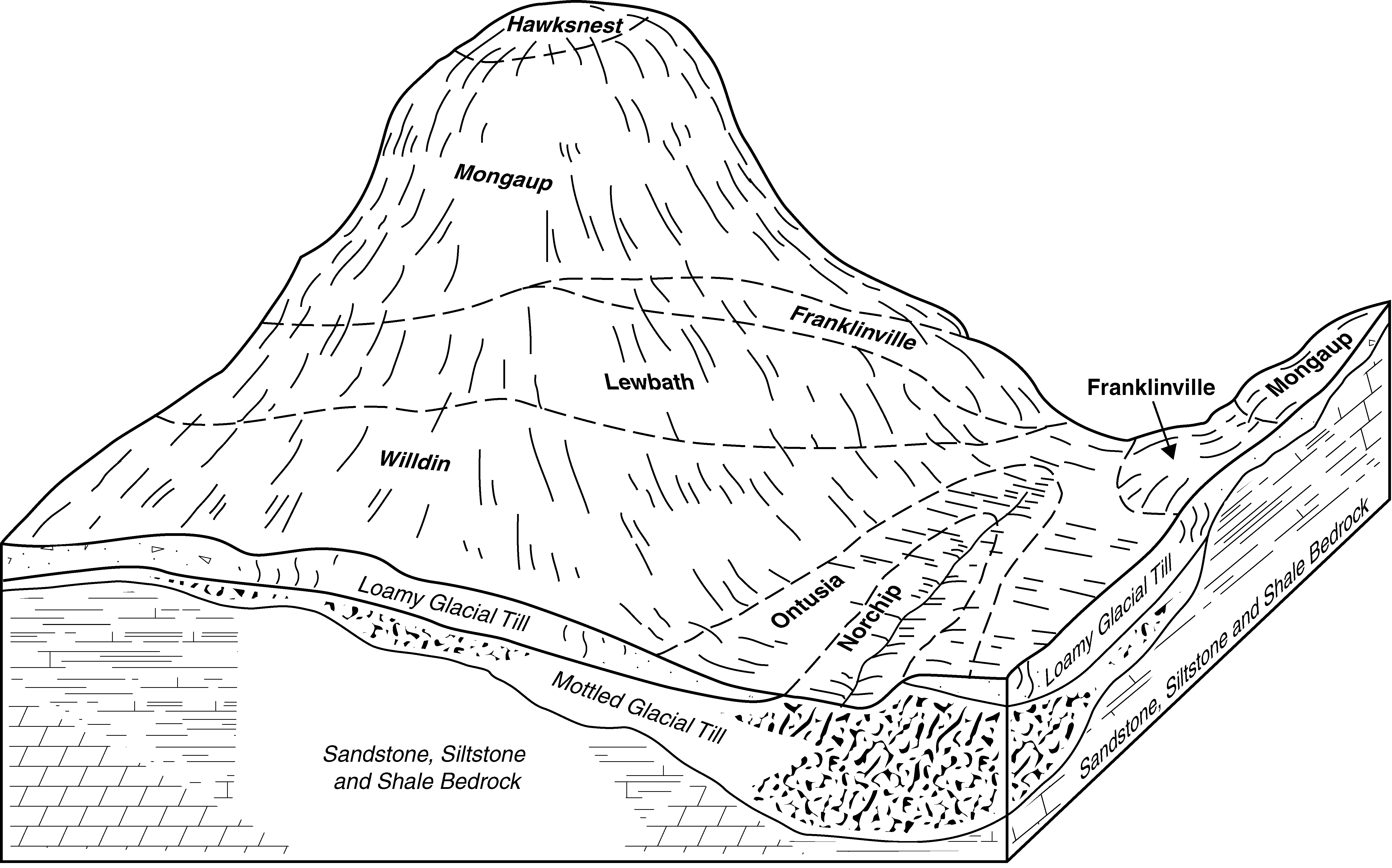
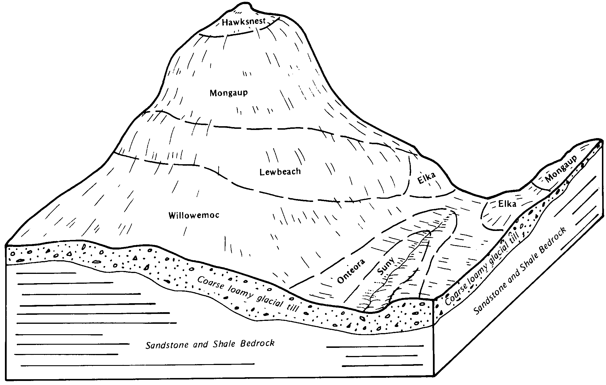
Mongaup-Hawksnest complex, 25 to 50 percent slopes, rocky | MnE | 19731 | 294256 | 9w64 | ny077 | 1993 | 1:24000 |
Mongaup-Franklinville complex, 8 to 15 percent slopes | MmC | 17561 | 294253 | 9w61 | ny077 | 1993 | 1:24000 |
Mongaup-Hawksnest complex, 1 to 8 percent slopes, rocky | MnB | 16913 | 294255 | 9w63 | ny077 | 1993 | 1:24000 |
Mongaup-Franklinville complex, 15 to 25 percent slopes | MmD | 16636 | 294254 | 9w62 | ny077 | 1993 | 1:24000 |
Hawksnest-Mongaup loams, strongly sloping, very rocky | HaC | 14153 | 295071 | 9x1f | ny105 | 1984 | 1:15840 |
Hawksnest-Mongaup loams, steep, very rocky | HaE | 12465 | 295072 | 9x1g | ny105 | 1984 | 1:15840 |
Hawksnest-Mongaup-Rock outcrop complex, very steep | HeF | 5437 | 295073 | 9x1h | ny105 | 1984 | 1:15840 |
Mongaup loam, 8 to 15 percent slopes, very stony | MnC | 3897 | 295090 | 9x21 | ny105 | 1984 | 1:15840 |
Mongaup loam, 3 to 8 percent slopes, very stony | MnB | 3277 | 295089 | 9x20 | ny105 | 1984 | 1:15840 |
Mongaup loam, 15 to 25 percent slopes, very stony | MnD | 1283 | 295091 | 9x22 | ny105 | 1984 | 1:15840 |
Mongaup-Ischua complex, 25 to 35 percent slopes, extremely stony | 181E | 1374 | 3250357 | 2q9m4 | ny123 | 1948 | 1:12000 |
Mongaup-Ischua complex, 15 to 25 percent slopes, very stony | 181D | 1155 | 3250335 | 2pq3h | ny123 | 1948 | 1:12000 |
Mongaup-Ischua complex, 8 to 15 percent slopes | 181C | 741 | 3250347 | 2pq3k | ny123 | 1948 | 1:12000 |
Mongaup-Ischua complex, 3 to 8 percent slopes | 181B | 16 | 3250346 | 2pq3j | ny123 | 1948 | 1:12000 |
Mongaup-Rockrift complex, 25 to 60 percent slopes, extremely stony | MqrF | 21172 | 2944224 | 2wbns | pa105 | 2007 | 1:24000 |
Mongaup channery silt loam, 3 to 8 percent slopes | MqB | 6508 | 2433090 | 2wzl5 | pa105 | 2007 | 1:24000 |
Mongaup channery silt loam, 8 to 15 percent slopes | MqC | 4701 | 2433093 | 2wzl6 | pa105 | 2007 | 1:24000 |
Mongaup channery silt loam, 15 to 25 percent slopes | MqD | 3553 | 2433094 | 2wzl7 | pa105 | 2007 | 1:24000 |
Mongaup channery loam, 3 to 15 percent slopes, extremely stony | MqsC | 2236 | 2433103 | 2wzl9 | pa105 | 2007 | 1:24000 |
Mongaup channery silt loam, 25 to 70 percent slopes | MqF | 1616 | 2944249 | 2wzl8 | pa105 | 2007 | 1:24000 |
Mongaup channery loam, 15 to 25 percent slopes, extremely stony | MqsD | 749 | 2433108 | 2wzlb | pa105 | 2007 | 1:24000 |


