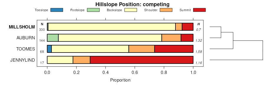
| Millsholm-Contra Costa association, 30 to 75 percent slopes | 334 | 74054 | 461634 | 2vf95 | ca011 | 1999 | 1:24000 |
Contra Costa-Millsholm complex, 50 to 75 percent slopes | 300 | 13739 | 461621 | hhc0 | ca011 | 1999 | 1:24000 |
Millsholm-Rock outcrop association, 30 to 75 percent slopes | 332 | 6647 | 461632 | hhcc | ca011 | 1999 | 1:24000 |
Skyhigh-Millsholm complex, 15 to 50 percent slopes | 280 | 6167 | 461620 | 2vfbb | ca011 | 1999 | 1:24000 |
Millsholm loam, 0 to 30 percent slopes, MLRA 15 | 320 | 5954 | 461627 | 2vfbc | ca011 | 1999 | 1:24000 |
Skyhigh-Sleeper-Millsholm association, 8 to 50 percent slopes, MLRA 15 | 345 | 4377 | 461666 | 2vbtw | ca011 | 1999 | 1:24000 |
Millsholm-Altamont-Rock outcrop complex, 5 to 15 percent slopes | 253 | 3151 | 461610 | hhbn | ca011 | 1999 | 1:24000 |
Millsholm-Contra Costa complex, 15 to 30 percent slopes | 330 | 2620 | 461630 | 2vfbf | ca011 | 1999 | 1:24000 |
Millsholm-Rock outcrop complex, 9 to 30 percent slopes | 255 | 2147 | 461612 | hhbq | ca011 | 1999 | 1:24000 |
Sehorn-Millsholm-Rock outcrop complex, 30 to 50 percent slopes | 331 | 1782 | 461631 | 2vfbg | ca011 | 1999 | 1:24000 |
Buttes-Millsholm complex, 30 to 50 percent slopes | 371 | 1252 | 461661 | 2vfbh | ca011 | 1999 | 1:24000 |
Millsholm-Capay complex, 3 to 9 percent slopes | 257 | 1191 | 461614 | hhbs | ca011 | 1999 | 1:24000 |
Skyhigh-Millsholm-Sleeper association, 30 to 50 percent slopes | 346 | 600 | 461665 | hhdf | ca011 | 1999 | 1:24000 |
Sehorn-Millsholm-Altamont complex, 15 to 30 percent slopes | 329 | 228 | 461629 | hhc8 | ca011 | 1999 | 1:24000 |
Millsholm-Saltcanyon association, 5 to 15 percent slopes | 337 | 181 | 461609 | 2vfb9 | ca011 | 1999 | 1:24000 |
Millsholm-Altamont complex, 15 to 30 percent slopes | 261 | 129 | 461615 | hhbt | ca011 | 1999 | 1:24000 |
Millsholm loam, 20 to 60 percent slopes, moist, MLRA 15 | MeG | 11960 | 455829 | 2vbtr | ca013 | 1973 | 1:24000 |
Millsholm loam, 15 to 50 percent slopes, moist, MLRA 15 | MeF | 10720 | 455828 | 2vbtk | ca013 | 1973 | 1:24000 |
Altamont-Fontana complex, 50 to 75 percent slopes | AcG | 4990 | 455762 | h980 | ca013 | 1973 | 1:24000 |
Cut and fill land-Millsholm complex, 9 to 30 percent slopes | CoE | 1860 | 455784 | h98q | ca013 | 1973 | 1:24000 |
Millsholm loam, 15 to 30 percent slopes, MLRA 15 | MeE | 850 | 455827 | 2t7qs | ca013 | 1973 | 1:24000 |
Cut and fill land-Millsholm complex, 30 to 50 percent slopes | CoF | 490 | 455785 | h98r | ca013 | 1973 | 1:24000 |
Xerorthents-Millsholm complex, 50 to 75 percent slopes | 160aw | 2 | 843740 | x9zf | ca013 | 1973 | 1:24000 |
Los Osos and Millsholm soils, 7 to 30 percent slopes | LuDaa | 1 | 843734 | x9z7 | ca013 | 1973 | 1:24000 |
Millsholm silt loam, 45 to 75 percent slopes, eroded | MhF2aa | 1 | 843736 | x9z9 | ca013 | 1973 | 1:24000 |
Los Osos and Millsholm soils, 30 to 45 percent slopes, eroded | LuE2aa | 1 | 843735 | x9z8 | ca013 | 1973 | 1:24000 |
Sehorn-Millsholm association, 15 to 50 percent slopes, MLRA 15 | SdE | 37952 | 458837 | 2y0g7 | ca021 | 1961 | 1:20000 |
Contra Costa-Millsholm association, 20 to 60 percent slopes, MLRA 15 | CvE | 7538 | 458619 | 2y0gp | ca021 | 1961 | 1:20000 |
Sehorn-Millsholm association, 3 to 30 percent slopes, MLRA 15 | SdD | 5872 | 458836 | 2y0gb | ca021 | 1961 | 1:20000 |
Millsholm-Contra Costa association, 15 to 60 percent slopes, eroded, MLRA 15 | MwE2 | 5870 | 458742 | 2y0gm | ca021 | 1961 | 1:20000 |
Millsholm-Rock outcrop complex, 15 to 55 percent slopes, MLRA 15 | MuE | 5476 | 458740 | 2y0gd | ca021 | 1961 | 1:20000 |
Millsholm-Altamont-Rock outcrop complex, 10 to 55 percent slopes, severely eroded, MLRA 15 | AkE3 | 4917 | 458575 | 2y0gv | ca021 | 1961 | 1:20000 |
Sehorn-Millsholm-Gullied land complex, 10 to 45 percent slopes, MLRA 15 | SeE | 3701 | 458839 | 2y0g8 | ca021 | 1961 | 1:20000 |
Millsholm gravelly loam, 25 to 70 percent slopes, schist bedrock, MLRA 15 | MkF | 3048 | 458723 | 2y0gh | ca021 | 1961 | 1:20000 |
Sehorn-Millsholm-Gullied land complex, 5 to 30 percent slopes, MLRA 15 | SeD | 2621 | 458838 | 2y0g9 | ca021 | 1961 | 1:20000 |
Millsholm silt loam, 10 to 30 percent slopes, MLRA 15 | MnD | 2229 | 458728 | 2t7qm | ca021 | 1961 | 1:20000 |
Millsholm gravelly loam, 20 to 55 percent slopes, schist bedrock, MLRA 15 | MkE | 1802 | 458722 | 2y0gj | ca021 | 1961 | 1:20000 |
Millsholm silty clay loam, 15 to 60 percent slopes, eroded, MLRA 15 | MnE2 | 1537 | 458730 | 2y0fx | ca021 | 1961 | 1:20000 |
Millsholm complex, 10 to 50 percent slopes, MLRA 15 | MvE | 1117 | 458741 | 2y0g3 | ca021 | 1961 | 1:20000 |
Millsholm very gravelly coarse sandy loam, 30 to 50 percent slopes, MLRA 15 | MrE | 1015 | 458736 | 2t7qv | ca021 | 1961 | 1:20000 |
Millsholm silt loam-Gullied land, 2 to 20 percent slopes, MLRA 15 | MngD | 937 | 458731 | 2y0g4 | ca021 | 1961 | 1:20000 |
Millsholm very gravelly coarse sandy loam, 20 to 55 percent slopes, eroded, MLRA 15 | MrE2 | 904 | 458737 | 2y0gg | ca021 | 1961 | 1:20000 |
Millsholm-Gullied land complex, 20 to 50 percent slopes, MLRA 15 | MsE | 776 | 458738 | 2y0g6 | ca021 | 1961 | 1:20000 |
Millsholm silt loam, 30 to 50 percent slopes, MLRA 15 | MnE | 767 | 458729 | 2t7qp | ca021 | 1961 | 1:20000 |
Millsholm-Lodo complex, 10 to 55 percent slopes, eroded, MLRA 15 | MyE2 | 747 | 458744 | 2y0gq | ca021 | 1961 | 1:20000 |
Millsholm gravelly loam, Mountains, 30 to 50 percent slopes, MLRA 15 | MhE | 606 | 458718 | 2t7qr | ca021 | 1961 | 1:20000 |
Sehorn-Millsholm association, 1 to 15 percent slopes, MLRA 15 | SdC | 563 | 458835 | 2y0gc | ca021 | 1961 | 1:20000 |
Millsholm loam, 3 to 30 percent slopes, MLRA 15 | MlD | 559 | 458724 | 2y0fy | ca021 | 1961 | 1:20000 |
Millsholm silt loam, 3 to 25 percent slopes, MLRA 15 | MoD | 491 | 458732 | 2y0g0 | ca021 | 1961 | 1:20000 |
Millsholm-Rock outcrop complex, 10 to 50 percent slopes, MLRA 15 | MoE | 389 | 458733 | 2y0g1 | ca021 | 1961 | 1:20000 |
Polebar-Millsholm-Gullied land complex, 15 to 50 percent slopes, MLRA 15 | PsE | 348 | 458815 | 2y0gt | ca021 | 1961 | 1:20000 |
Millsholm-Rock outcrop-Gullied land complex, 5 to 30 percent slopes, MLRA 15 | MmD | 337 | 458726 | 2y0gr | ca021 | 1961 | 1:20000 |
Millsholm loam-Gullied land complex, 10 to 55 percent slopes, MLRA 15 | MmE | 319 | 458727 | 2y0gs | ca021 | 1961 | 1:20000 |
Millsholm-Rock outcrop complex, 10 to 40 percent slopes, MLRA 15 | MtD | 307 | 458739 | 2y0g2 | ca021 | 1961 | 1:20000 |
Millsholm-Contra Costa complex, 15 to 45 percent slopes, MLRA 15 | MxE | 305 | 458743 | 2y0gn | ca021 | 1961 | 1:20000 |
Millsholm-Gullied land complex, 10 to 45 percent slopes, MLRA 15 | MpE | 212 | 458734 | 2y0g5 | ca021 | 1961 | 1:20000 |
Millsholm gravelly loam, 30 to 70 percent slopes, chert bedrock, MLRA 15 | MgF | 151 | 458717 | 2y0gk | ca021 | 1961 | 1:20000 |
Millsholm loam, 10 to 45 percent slopes, MLRA 15 | MlE | 137 | 458725 | 2y0fz | ca021 | 1961 | 1:20000 |
Millsholm gravelly loam, 30 to 60 percent slopes, MLRA 15 | MhF | 122 | 458719 | 2y0gl | ca021 | 1961 | 1:20000 |
Millsholm very gravelly coarse sandy loam, 5 to 20 percent slopes, MLRA 15 | MrD | 29 | 458735 | 2y0gf | ca021 | 1961 | 1:20000 |
Millsholm clay loam, 50 to 75 percent slopes | 146 | 1573 | 461807 | hhk0 | ca031 | 1980 | 1:24000 |
Vaquero-Altamont-Millsholm complex, 15 to 50 percent sl opes | 171 | 1545 | 461832 | hhkt | ca031 | 1980 | 1:24000 |
Millsholm clay loam, 15 to 50 percent slopes | 145 | 417 | 461806 | hhjz | ca031 | 1980 | 1:24000 |
Skyhigh-Millsholm loams, 15 to 50 percent slopes | 209 | 24629 | 459612 | hf86 | ca033 | 1985 | 1:24000 |
Millsholm-Bressa loams, 30 to 50 percent slopes | 177 | 15416 | 459580 | hf75 | ca033 | 1985 | 1:24000 |
Millsholm-Bressa-Hopland association, 30 to 50 percent slopes | 178 | 12905 | 459581 | hf76 | ca033 | 1985 | 1:24000 |
Maymen-Millsholm-Bressa complex, 30 to 50 percent slopes | 175 | 12738 | 459578 | hf73 | ca033 | 1985 | 1:24000 |
Bressa-Millsholm loams, 15 to 30 percent slopes | 120 | 6523 | 459523 | hf5b | ca033 | 1985 | 1:24000 |
Skyhigh-Sleeper-Millsholm association, 30 to 50 percent slopes | 212 | 3844 | 459615 | hf89 | ca033 | 1985 | 1:24000 |
Millsholm-Ashokawna-Pomo complex, 30 to 50 percent slopes | 179 | 1655 | 459582 | hf77 | ca033 | 1985 | 1:24000 |
Skyhigh-Sleeper-Millsholm association, 1 to 35 percent slopes, MLRA 15 | 211 | 1619 | 459614 | 2vbtv | ca033 | 1985 | 1:24000 |
Speaker-Maymen-Millsholm association, 30 to 50 percent slopes | 227 | 1422 | 459630 | hf8s | ca033 | 1985 | 1:24000 |
Bressa-Millsholm loams, 8 to 15 percent slopes | 119 | 1156 | 459522 | hf59 | ca033 | 1985 | 1:24000 |
Skyhigh-Sleeper-Millsholm association, 8 to 15 percent slopes | 210 | 575 | 459613 | hf87 | ca033 | 1985 | 1:24000 |
Alo-Millsholm complex | Ab | 13000 | 455541 | h90w | ca053 | 1972 | 1:24000 |
Millsholm-Alo association | Mk | 9700 | 455665 | h94w | ca053 | 1972 | 1:24000 |
Millsholm-Gazos complex | Mm | 8035 | 455666 | h94x | ca053 | 1972 | 1:24000 |
Millsholm loam, 15 to 65 percent slopes, MLRA 15 | MhG | 5960 | 455664 | 2vbtm | ca053 | 1972 | 1:24000 |
Los Osos-Millsholm complex | Ln | 2785 | 455652 | h94g | ca053 | 1972 | 1:24000 |
Maymen-Millsholm-Lodo association, 30-75 percent slopes | 163 | 30460 | 458987 | hdm1 | ca055 | 1974 | 1:24000 |
Millsholm loam, 6 to 55 percent slopes, MLRA 15 | 165 | 4875 | 458989 | 2vbtn | ca055 | 1974 | 1:24000 |
Millsholm loam, 15 to 30 percent slopes, MLRA 15 | 164 | 1280 | 458988 | 2t7qs | ca055 | 1974 | 1:24000 |
Skyhigh-Millsholm loams, 15 to 50 percent slopes | 209l | 64 | 813835 | w9vr | ca055 | 1974 | 1:24000 |
Maymen-Millsholm-Bressa complex, 30 to 50 percent slopes | 175l | 61 | 813831 | w9vm | ca055 | 1974 | 1:24000 |
Millsholm loam, 15 to 65 percent slopes, eroded, MLRA 15 | MmG2so | 48 | 816482 | 2vbtp | ca055 | 1974 | 1:24000 |
Roacha-Millsholm-Lilten association, 30 to 65 percent slopes | 770fw | 875 | 2562651 | hp29 | ca069 | 1965 | 1:20000 |
Millsholm-Borreguero complex, 30 to 65 percent slopes | 743fw | 176 | 2562642 | hp1q | ca069 | 1965 | 1:20000 |
Lilten-Millsholm association, 30 to 65 percent slopes | 744fw | 160 | 2562643 | hp1r | ca069 | 1965 | 1:20000 |
Millsholm loam, 15 to 65 percent slopes, eroded, MLRA 15 | MmG2 | 11098 | 456097 | 2vbtp | ca095 | 1969 | 1:24000 |
Millsholm loam, 15 to 30 percent slopes, MLRA 15 | MmE | 2321 | 456096 | 2t7qs | ca095 | 1969 | 1:24000 |
Millsholm loam, moderately deep variant, 9 to 30 percent slopes | MnE | 766 | 456099 | h9lw | ca095 | 1969 | 1:24000 |
Millsholm loam, moderately deep variant, 2 to 9 percent slopes | MnC | 222 | 456098 | h9lv | ca095 | 1969 | 1:24000 |
Skyhigh-Millsholm loams, 15 to 50 percent slopes | 209l | | 1607739 | 1qyzk | ca097 | 1968 | 1:20000 |
Millsholm rocky loam, 15 to 75 percent slopes, eroded | MrG2 | 30339 | 459249 | hdwh | ca113 | 1968 | 1:20000 |
Dibble-Millsholm complex, 50 to 75 percent slopes, eroded | DbG2 | 5850 | 459227 | hdvs | ca113 | 1968 | 1:20000 |
Maymen-Millsholm-Lodo association, 30-75 percent slopes | 163n | 2093 | 765509 | tpkv | ca113 | 1968 | 1:20000 |
Dibble-Millsholm complex, 30 to 50 percent slopes, eroded | DbF2 | 1820 | 459226 | hdvr | ca113 | 1968 | 1:20000 |
Dibble-Millsholm complex, 9 to 30 percent slopes, eroded | DbE2 | 804 | 459225 | hdvq | ca113 | 1968 | 1:20000 |
Millsholm loam, 0 to 30 percent slopes, MLRA 15 | 320c | 113 | 757757 | 2vfbc | ca113 | 1968 | 1:20000 |
Skyhigh-Millsholm complex, 15 to 50 percent slopes | 280c | 24 | 757756 | tfhr | ca113 | 1968 | 1:20000 |
Millsholm loam, 6 to 55 percent slopes, MLRA 15 | 165n | 7 | 765510 | 2vbtn | ca113 | 1968 | 1:20000 |
MILLSHOLM-AZULE COMPLEX, 15 TO 30 PERCENT SLOPES | 176 | 1588 | 466076 | hmzq | ca606 | 1990 | 1:24000 |
MILLSHOLM LOAM, 5 TO 9 PERCENT SLOPES | 175 | 353 | 466075 | hmzp | ca606 | 1990 | 1:24000 |
Millsholm gravelly loam, 30 to 50 percent slopes, MLRA 15 | MeE | 11908 | 460061 | 2t7qq | ca607 | 1967 | 1:20000 |
Millsholm gravelly loam, 3 to 30 percent slopes | MeD | 10419 | 460059 | hfqm | ca607 | 1967 | 1:20000 |
Millsholm very rocky loam, 30 to 50 percent slopes, eroded | MfE2 | 4932 | 460063 | hfqr | ca607 | 1967 | 1:20000 |
Millsholm gravelly loam, 50 to 75 percent slopes | MeG | 2984 | 460062 | hfqq | ca607 | 1967 | 1:20000 |
Millsholm very rocky loam, 50 to 70 percent slopes, eroded | MfF2 | 1764 | 460064 | hfqs | ca607 | 1967 | 1:20000 |
Millsholm gravelly loam, 3 to 30 percent slopes, eroded | MeD2 | 1241 | 460060 | hfqn | ca607 | 1967 | 1:20000 |
Millsholm silt loam, 30 to 45 percent slopes, eroded | MhE2 | 11334 | 456601 | hb42 | ca609 | 1963 | 1:20000 |
Millsholm silt loam, 45 to 75 percent slopes, eroded | MhF2 | 10061 | 456602 | hb43 | ca609 | 1963 | 1:20000 |
Los Osos and Millsholm soils, 30 to 45 percent slopes, eroded | LuE2 | 5466 | 456600 | hb41 | ca609 | 1963 | 1:20000 |
Los Osos and Millsholm soils, 7 to 30 percent slopes | LuD | 4185 | 456599 | hb40 | ca609 | 1963 | 1:20000 |
Millsholm silt loam, 50 to 75 percent slopes | 129aw | 423 | 843527 | x9rk | ca609 | 1963 | 1:20000 |
Los Osos-Millsholm complex, 30 to 50 percent slopes | 123aw | 266 | 801691 | vx70 | ca609 | 1963 | 1:20000 |
Millsholm loam, 15 to 50 percent slopes, moist, MLRA 15 | MeFcc | 101 | 801723 | 2vbtk | ca609 | 1963 | 1:20000 |
Millsholm loam, 20 to 60 percent slopes, moist, MLRA 15 | MeGcc | 100 | 801724 | 2vbtr | ca609 | 1963 | 1:20000 |
Los Osos-Millsholm complex, 9 to 30 percent slopes | 122aw | 88 | 801690 | vx6z | ca609 | 1963 | 1:20000 |
Los Osos and Millsholm soils, 30 to 45 percent slopes, eroded | LuE2aa | | 801700 | vx79 | ca610 | 1975 | 1:24000 |
Los Osos and Millsholm soils, 7 to 30 percent slopes | LuDaa | | 801699 | vx78 | ca610 | 1975 | 1:24000 |
Xerorthents-Millsholm complex, 30 to 50 percent slopes | 159 | 3389 | 456712 | hb7n | ca610 | 1975 | 1:24000 |
Los Osos-Millsholm complex, 9 to 30 percent slopes | 122 | 1619 | 456675 | hb6g | ca610 | 1975 | 1:24000 |
Xerorthents-Millsholm complex, 50 to 75 percent slopes | 160 | 1441 | 456713 | hb7p | ca610 | 1975 | 1:24000 |
Millsholm silt loam, 30 to 50 percent slopes | 128 | 1401 | 456681 | hb6n | ca610 | 1975 | 1:24000 |
Millsholm silt loam, 50 to 75 percent slopes | 129 | 967 | 456682 | hb6p | ca610 | 1975 | 1:24000 |
Los Osos-Millsholm complex, 30 to 50 percent slopes | 123 | 932 | 456676 | hb6h | ca610 | 1975 | 1:24000 |
Los Osos-Millsholm complex, 50 to 75 percent slopes | 124 | 258 | 456677 | hb6j | ca610 | 1975 | 1:24000 |
Millsholm loam, 20 to 60 percent slopes, moist, MLRA 15 | MeGcc | 99 | 825141 | 2vbtr | ca610 | 1975 | 1:24000 |
Millsholm loam, 25 to 55 percent slopes, dry, MLRA 15 | 635 | 4050 | 466994 | 2vbtq | ca642 | 1998 | 1:24000 |
Millsholm-Honker-Rock outcrop complex, 15 to 50 percent slopes, MLRA 15 | 630 | 3240 | 466992 | 2vbtt | ca642 | 1998 | 1:24000 |
Quinto-Millsholm-Rock outcrop complex, 40 to 75 percent slopes | 640 | 1240 | 466995 | hnyc | ca642 | 1998 | 1:24000 |
Millsholm-Honker-Rock outcrop complex, 50 to 75 percent slopes | 631 | 200 | 466993 | hny9 | ca642 | 1998 | 1:24000 |
Millsholm loam, 15 to 50 percent slopes, MLRA 15 | MtE | 25578 | 460843 | 2t7qn | ca645 | 1961 | 1:20000 |
Sehorn-Millsholm complex, 30 to 50 percent slopes | SmE | 8336 | 460925 | 2vf9d | ca645 | 1961 | 1:20000 |
Lodo-Millsholm complex, 30 to 50 percent slopes | LfE | 8105 | 460804 | 2vfbl | ca645 | 1961 | 1:20000 |
Sehorn-Millsholm complex, 10 to 30 percent slopes | SmD | 6269 | 460924 | 2vf9c | ca645 | 1961 | 1:20000 |
Hillgate-Millsholm complex, 3 to 30 percent slopes | HtD | 5581 | 460760 | hgg7 | ca645 | 1961 | 1:20000 |
Millsholm clay loam, 50 to 65 percent slopes | MtF | 4276 | 460844 | hgjy | ca645 | 1961 | 1:20000 |
Lodo-Millsholm complex, 10 to 30 percent slopes | LfD | 3684 | 460803 | 2vf9t | ca645 | 1961 | 1:20000 |
Millsholm loam, 10 to 30 percent slopes, MLRA 15 | MtD | 2805 | 460842 | 2t7ql | ca645 | 1961 | 1:20000 |
Millsholm-Millsap complex, 30 to 50 percent slopes | MvE | 2160 | 460848 | 2vfb7 | ca645 | 1961 | 1:20000 |
Millsholm-Millsap complex, 10 to 30 percent slopes | MvD | 1329 | 460847 | hgk1 | ca645 | 1961 | 1:20000 |
Millsholm very gravelly coarse sandy loam, 30 to 50 percent slopes, MLRA 15 | MuE | 858 | 460845 | 2t7qv | ca645 | 1961 | 1:20000 |
Millsholm rocky sandy loam, 50 to 65 percent slopes | MuF | 285 | 460846 | 2vfb6 | ca645 | 1961 | 1:20000 |
Millsholm-Millsap complex, 50 to 65 percent slopes | MvF | 269 | 460849 | 2vfb8 | ca645 | 1961 | 1:20000 |
Lodo-Millsholm complex, 50 to 65 percent slopes | LfF | 256 | 460805 | 2vf9v | ca645 | 1961 | 1:20000 |
Millsholm gravelly loam, 50 to 75 percent slopes | MeGsh | 3 | 2766080 | hfqq | ca645 | 1961 | 1:20000 |
Millsholm gravelly loam, 30 to 50 percent slopes, MLRA 15 | MeEsh | 1 | 2766079 | 2t7qq | ca645 | 1961 | 1:20000 |
Millsholm-Honker-Rock outcrop complex, 15 to 50 percent slopes, MLRA 15 | 630ws | 602 | 699652 | 2vbtt | ca646 | 1967 | 1:24000 |
Millsholm loam, 4 to 30 percent slopes, MLRA 15 | 213wm | 199 | 699677 | 2vbth | ca646 | 1967 | 1:24000 |
Millsholm loam, 15 to 45 percent slopes, dry, MLRA 15 | 214wm | 185 | 699678 | 2vbtj | ca646 | 1967 | 1:24000 |
Millsholm - Rock outcrop complex, 4 to 30 percent slopes, dry, MLRA 15 | 218wm | 31 | 699680 | 2vbts | ca646 | 1967 | 1:24000 |
Millsholm loam, 25 to 55 percent slopes, dry, MLRA 15 | 635ws | 24 | 699653 | 2vbtq | ca646 | 1967 | 1:24000 |
Millsholm silt loam, 30 to 45 percent slopes, eroded | MhE2aa | 13 | 699381 | rgrp | ca646 | 1967 | 1:24000 |
Quinto-Millsholm-Rock outcrop complex, 40 to 75 percent slopes | 242 | 14290 | 462894 | hjp2 | ca647 | 1984 | 1:24000 |
Millsholm loam, 15 to 45 percent slopes, dry, MLRA 15 | 214 | 8720 | 462866 | 2vbtj | ca647 | 1984 | 1:24000 |
Millsholm loam, 25 to 55 percent slopes, dry, MLRA 15 | 215 | 5210 | 462867 | 2vbtq | ca647 | 1984 | 1:24000 |
Millsholm-Honker-Rock outcrop complex, 15 to 50 percent slopes, MLRA 15 | 217 | 4740 | 462869 | 2vbtt | ca647 | 1984 | 1:24000 |
Fifield-Millsholm , 30 to 50 percent slopes | 185 | 4510 | 462837 | hjm7 | ca647 | 1984 | 1:24000 |
Honker-Millsholm-Rock outcrop complex, 30 to 50 percent slopes | 196 | 3250 | 462848 | hjml | ca647 | 1984 | 1:24000 |
Millsholm-Rock outcrop complex 30 to 50 percent slopes | 219 | 2300 | 462871 | hjnb | ca647 | 1984 | 1:24000 |
Millsholm - Rock outcrop complex, 4 to 30 percent slopes, dry, MLRA 15 | 218 | 1570 | 462870 | 2vbts | ca647 | 1984 | 1:24000 |
Millsholm-Fifield complex, 30 to 50 percent slopes | 216 | 610 | 462868 | hjn7 | ca647 | 1984 | 1:24000 |
Millsholm loam, 4 to 30 percent slopes, MLRA 15 | 213 | 560 | 462865 | 2vbth | ca647 | 1984 | 1:24000 |
Roacha-Millsholm-Lilten association, 30 to 65 percent slopes | 770 | 26952 | 467117 | hp29 | ca653 | 2000 | 1:24000 |
Millsholm-Wisflat-Lilten association, 30 to 65 percent slopes | 742 | 9493 | 467098 | hp1p | ca653 | 2000 | 1:24000 |
Lilten-Millsholm association, 30 to 65 percent slopes | 744 | 7655 | 467100 | hp1r | ca653 | 2000 | 1:24000 |
Millsholm-Borreguero complex, 30 to 65 percent slopes | 743 | 2387 | 467099 | hp1q | ca653 | 2000 | 1:24000 |
Quinto-Millsholm-Rock outcrop complex, 40 to 75 percent slopes | 842 | 1011 | 467153 | hp3g | ca653 | 2000 | 1:24000 |
Millsholm-Dibble complex, 30 to 50 percent slopes | 170 | 14140 | 457273 | hbtr | ca665 | 1977 | 1:24000 |
Millsholm-Rock outcrop complex, 50 to 75 percent slopes | 172 | 5655 | 457275 | hbtt | ca665 | 1977 | 1:24000 |
Millsholm-Ayar complex, 50 to 75 percent slopes | 168 | 3415 | 457271 | hbtp | ca665 | 1977 | 1:24000 |
Millsholm-Dibble complex, 15 to 30 percent slopes | 169 | 1845 | 457272 | hbtq | ca665 | 1977 | 1:24000 |
Millsholm-Montara complex, 15 to 30 percent slopes | 171 | 1065 | 457274 | hbts | ca665 | 1977 | 1:24000 |
Vaquero-Altamont-Millsholm complex, 15 to 50 percent slopes | 171ki | | 2218154 | 2dg5c | ca666 | 1983 | 1:24000 |
Millsholm variant-Rock outcrop complex, 50 to 75 percent slopes | 202 | 450 | 463747 | hkkl | ca666 | 1983 | 1:24000 |
Millsholm variant-Rock outcrop complex, 15 to 50 percent slopes | 201 | 293 | 463746 | hkkk | ca666 | 1983 | 1:24000 |
Millsholm variant-Ayar association, 50 to 75 percent slopes | 199 | 185 | 463744 | hkkh | ca666 | 1983 | 1:24000 |
Millsholm variant-Montara complex, 15 to 30 percent slopes | 200 | 155 | 463745 | hkkj | ca666 | 1983 | 1:24000 |
Saltos-Millsholm complex, 15 to 30 percent slopes | 531 | 3380 | 458543 | hd4q | ca667 | 2003 | 1:24000 |
Millsholm very rocky loam, 30 to 75 percent slopes | MkG | 4350 | 457735 | hc9n | ca674 | 1968 | 1:24000 |
Millsholm loam, 15 to 50 percent slopes | MhF | 3833 | 457734 | hc9m | ca674 | 1968 | 1:24000 |
Millsholm-Malibu complex, 30 to 50 percent slopes, eroded | MmF2 | 860 | 457736 | hc9p | ca674 | 1968 | 1:24000 |
Millsholm rocky loam, 30 to 50 percent slopes, eroded | MhF2 | 10189 | 457864 | hcft | ca675 | 1968 | 1:24000 |
Millsholm rocky loam, 15 to 30 percent slopes, eroded | MhE2 | 1221 | 457863 | hcfs | ca675 | 1968 | 1:24000 |
Millsholm loam, 15 to 75 percent slopes, MLRA 20 | 122 | 1345 | 456024 | 2vbtl | ca676 | 1975 | 1:24000 |
Millsholm loam, 15 to 50 percent slopes | MhFvt | | 3003615 | hc9m | ca692 | 2001 | 1:24000 |
Millsholm family, 20 to 60 percent slopes. | 195 | 5762 | 470793 | hsww | ca707 | 1983 | 1:24000 |
Millsholm very rocky loam, 30 to 50 percent slopes, eroded | MfE2sh | 190 | 1868434 | 20q82 | ca707 | 1983 | 1:24000 |
Millsholm very rocky loam, 50 to 70 percent slopes, eroded | MfF2sh | 187 | 1868436 | 20q84 | ca707 | 1983 | 1:24000 |
Millsholm gravelly loam, 3 to 30 percent slopes | MeDsh | 104 | 1868428 | 20q7w | ca707 | 1983 | 1:24000 |
Millsholm gravelly loam, 50 to 75 percent slopes | MeGsh | 13 | 1868432 | 20q80 | ca707 | 1983 | 1:24000 |
Millsholm gravelly loam, 30 to 50 percent slopes, MLRA 15 | MeEsh | 11 | 1868430 | 2t7qq | ca707 | 1983 | 1:24000 |
Millsholm gravelly loam, schist bedrock, 30 to 50 percent slope | MkEgl | 19 | 2747901 | 2q41f | ca709 | 2010 | 1:24000 |
Millsholm-Exchequer-Stonyford families complex, 30 to 75 percent slopes | 29 | 153835 | 465295 | hm5j | ca772 | 1981 | 1:24000 |
Yorba-Millsholm-Stonyford families association, 30 to 60 percent slopes | 51 | 116440 | 465320 | hm6b | ca772 | 1981 | 1:24000 |
Millerton-Millsholm-Agua Dulce families association, 30 to 60 percent slopes | 25 | 111978 | 465291 | hm5d | ca772 | 1981 | 1:24000 |
Modesto-Rincon-Millsholm families association, 20 to 50 percent slopes | 31 | 42310 | 465298 | hm5m | ca772 | 1981 | 1:24000 |
Lodo-Hambright-Millsholm families association, 30 to 60 percent slopes | 16 | 35276 | 465281 | hm52 | ca772 | 1981 | 1:24000 |
Millerton-Millsholm families-Rock outcrop complex, 30 to 80 percent slopes | 26 | 32197 | 465292 | hm5f | ca772 | 1981 | 1:24000 |
Millsholm-Reliz families-Rock outcrop association, 40 to 65 percent slopes | 30 | 16405 | 465297 | hm5l | ca772 | 1981 | 1:24000 |
Stonyford-Millsholm families complex, 30 to 70 percent slopes | 26 | 16480 | 465333 | hm6r | ca776 | 1981 | 1:24000 |
Millsholm rocky loam, 30 to 50 percent slopes, eroded | MhF2 | 37 | 779883 | v5jj | ca776 | 1981 | 1:24000 |