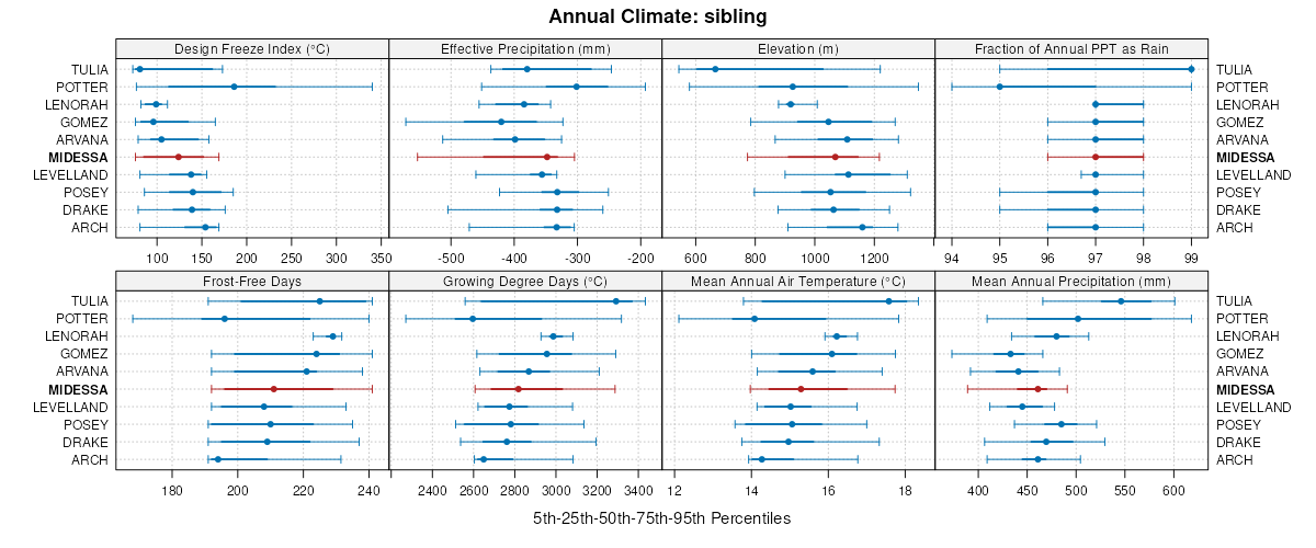
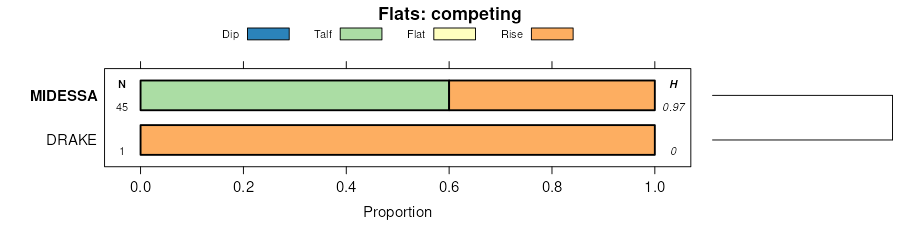
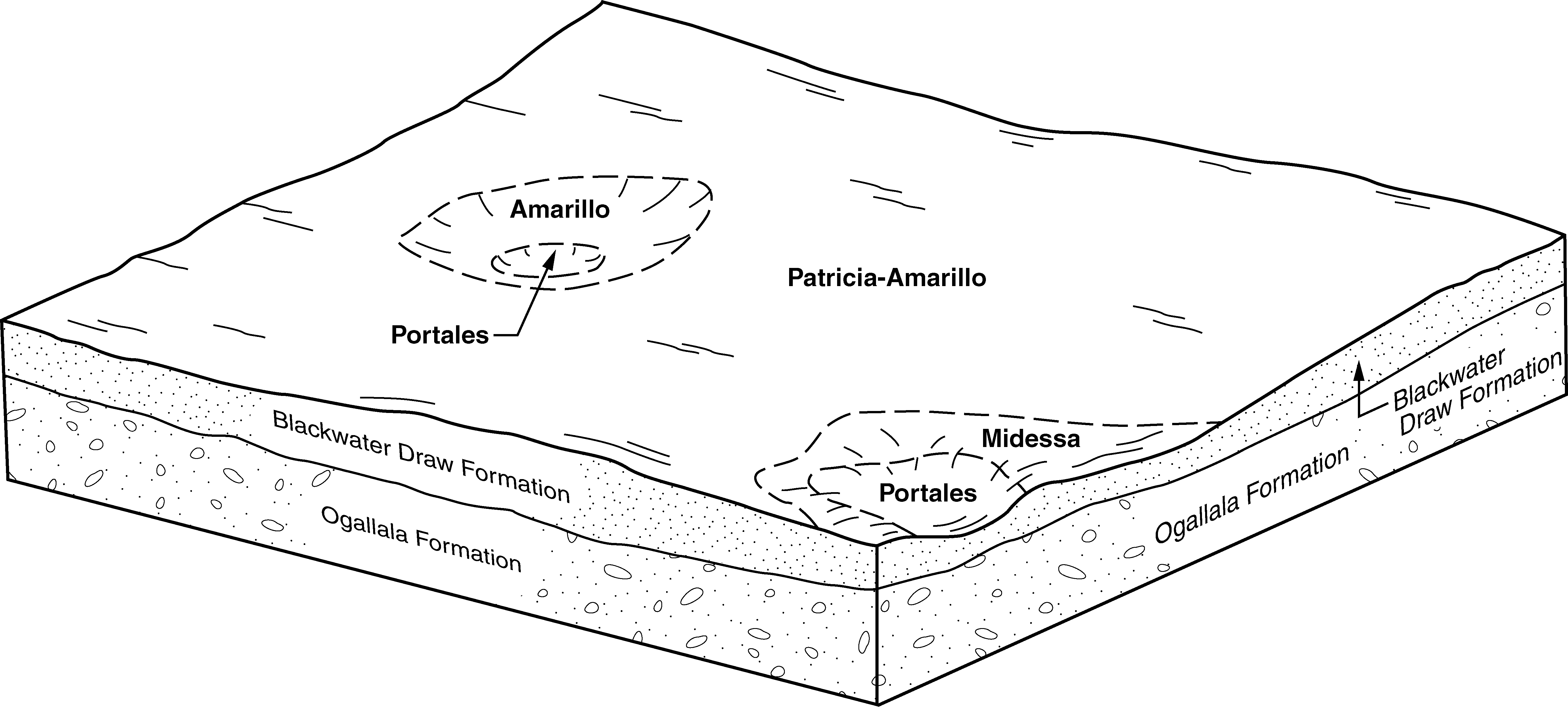
| Midessa fine sandy loam, 0 to 1 percent slopes | MdA | 34249 | 1547907 | f5sm | nm041 | 2014 | 1:24000 |
Midessa fine sandy loam, 1 to 3 percent slopes | MdB | 14835 | 1547908 | f5sn | nm041 | 2014 | 1:24000 |
Midessa fine sandy loam, 0 to 1 percent slopes | PfA | 50751 | 362598 | f5sm | tx017 | 1960 | 1:20000 |
Midessa fine sandy loam, 1 to 3 percent slopes | PfB | 19350 | 362599 | f5sn | tx017 | 1960 | 1:20000 |
Midessa fine sandy loam, 0 to 1 percent slopes | MdA | 23196 | 2931522 | f5sm | tx079 | 1962 | 1:20000 |
Midessa fine sandy loam, 1 to 3 percent slopes | MdB | 14044 | 2931523 | f5sn | tx079 | 1962 | 1:20000 |
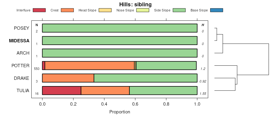
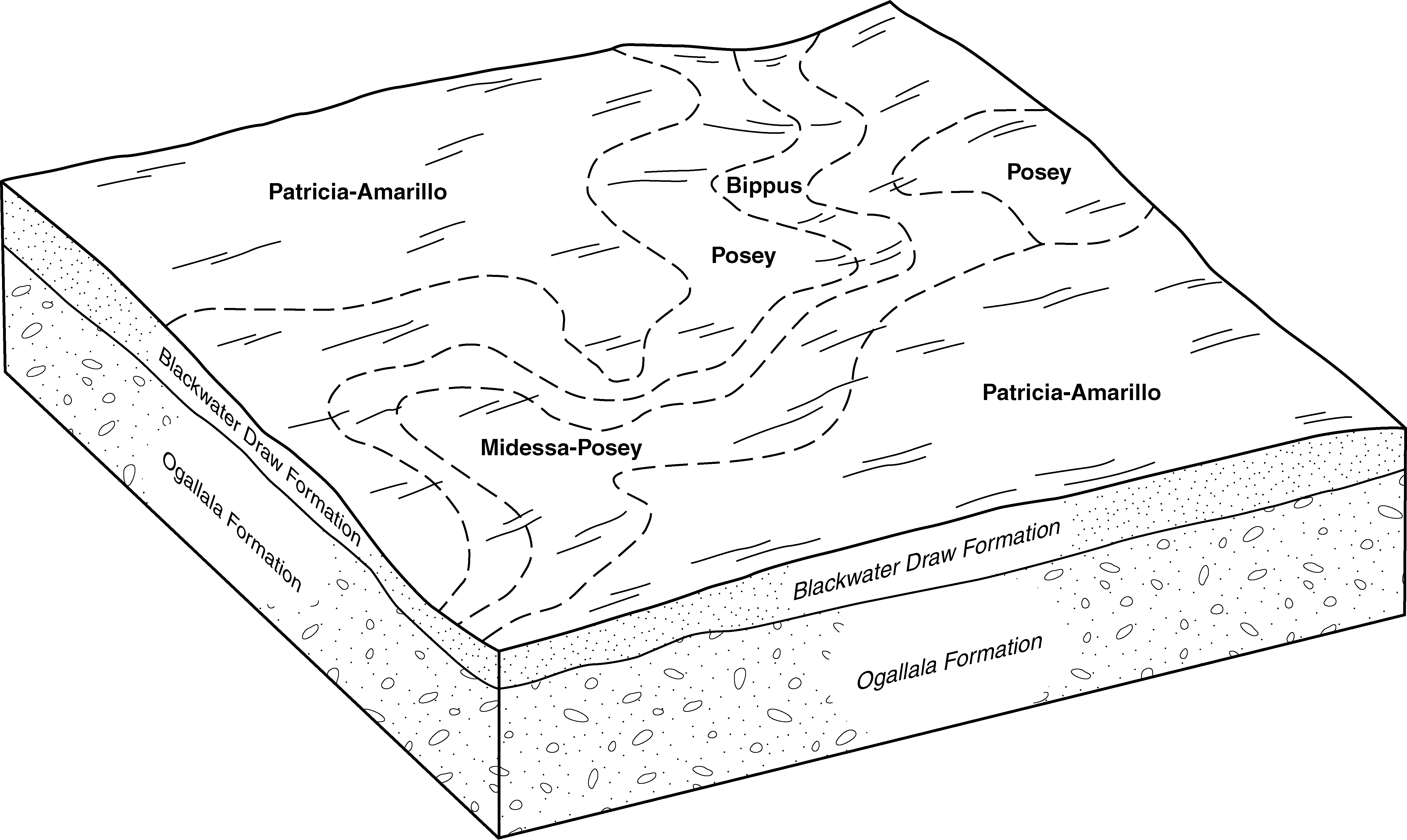
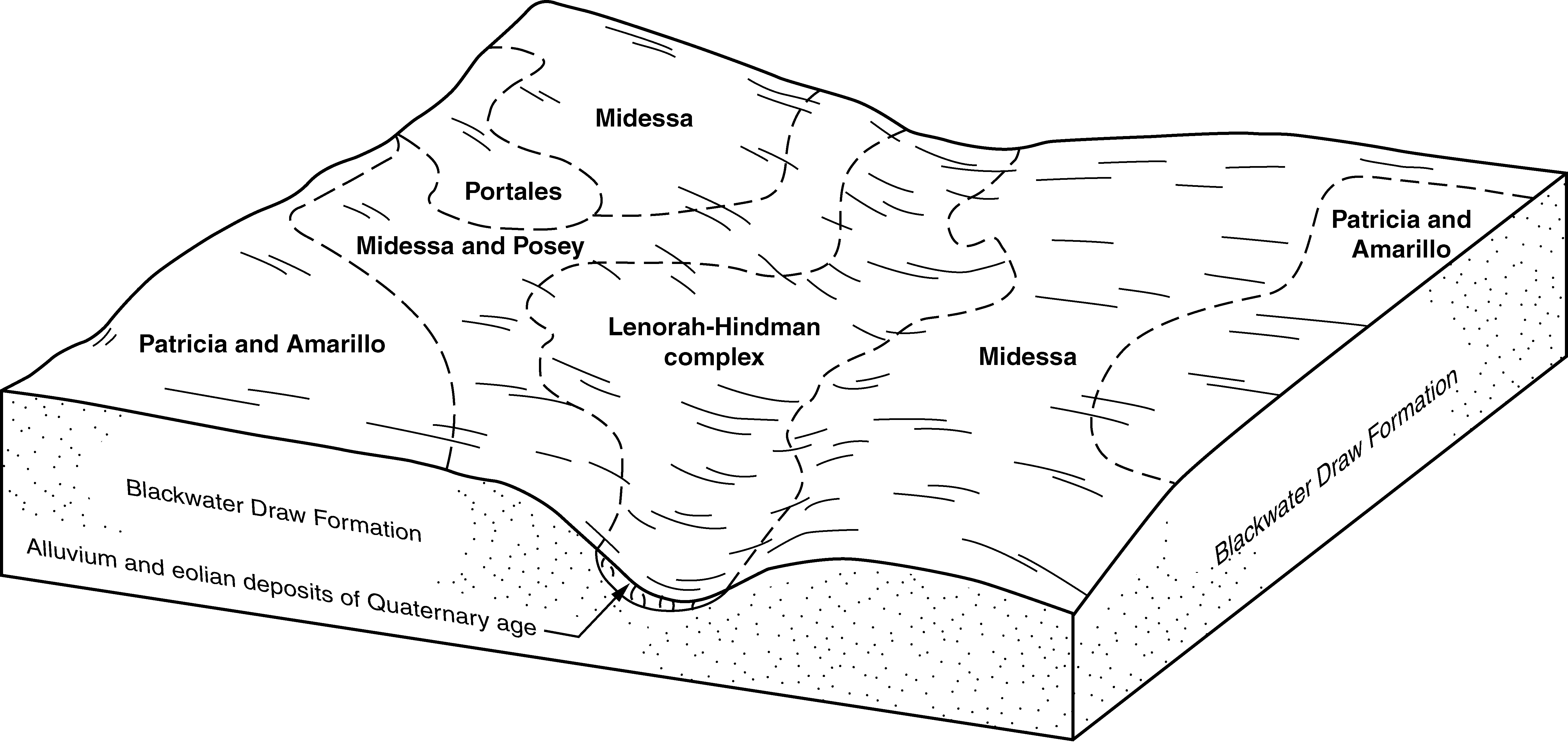
Midessa and Posey fine sandy loams, 3 to 8 percent slopes | MPC | 1943 | 2931525 | f5sq | tx079 | 1962 | 1:20000 |
Midessa, Potter and Posey soils, 3 to 12 percent slopes | MPP | 1164 | 2931526 | f5sr | tx079 | 1962 | 1:20000 |
Midessa fine sandy loam, 3 to 8 percent slopes | MdC | 599 | 2931524 | f5sp | tx079 | 1962 | 1:20000 |
Midessa fine sandy loam, 0 to 1 percent slopes | PfA | 2255 | 364730 | f5sm | tx107 | 1964 | 1:20000 |
Midessa fine sandy loam, 1 to 3 percent slopes | PfB | 241 | 364731 | f5sn | tx107 | 1964 | 1:20000 |
Midessa fine sandy loam, 1 to 3 percent slopes | MdB | 9885 | 393620 | f5sn | tx115 | 2004 | 1:24000 |
Midessa and Posey fine sandy loams, 3 to 8 percent slopes | MPC | 7386 | 393618 | f5sq | tx115 | 2004 | 1:24000 |
Midessa fine sandy loam, 0 to 1 percent slopes | MdA | 3558 | 393619 | f5sm | tx115 | 2004 | 1:24000 |
Midessa fine sandy loam, 3 to 8 percent slopes | MdC | 857 | 740645 | f5sp | tx115 | 2004 | 1:24000 |
Midessa fine sandy loam, 0 to 1 percent slopes | PfA | 23905 | 366044 | f5sm | tx165 | 1964 | 1:20000 |
Midessa fine sandy loam, 1 to 3 percent slopes | PfB | 5575 | 366045 | f5sn | tx165 | 1964 | 1:20000 |
Midessa fine sandy loam, 0 to 1 percent slopes | MfA | 17064 | 366242 | f5sm | tx173 | 1974 | 1:31680 |
Midessa fine sandy loam, 1 to 3 percent slopes | MfB | 12729 | 366243 | f5sn | tx173 | 1974 | 1:31680 |
Midessa fine sandy loam, 3 to 5 percent slopes | MfC | 2067 | 366244 | d93b | tx173 | 1974 | 1:31680 |
Midessa fine sandy loam, 1 to 3 percent slopes | MsB | 696 | 366909 | f5sn | tx189 | 1969 | 1:20000 |
Midessa fine sandy loam, 0 to 1 percent slopes | MsA | 314 | 366908 | f5sm | tx189 | 1969 | 1:20000 |
Midessa fine sandy loam, 1 to 3 percent slopes | MdB | 10386 | 378986 | f5sn | tx219 | 1999 | 1:24000 |
Midessa fine sandy loam, 0 to 1 percent slopes | MdA | 7140 | 378985 | f5sm | tx219 | 1999 | 1:24000 |
Midessa and Posey fine sandy loams, 3 to 8 percent slopes | MPC | 2611 | 379006 | f5sq | tx219 | 1999 | 1:24000 |
Midessa fine sandy loam, 0 to 1 percent slopes | PfA | 16094 | 391897 | f5sm | tx227 | 1965 | 1:24000 |
Midessa fine sandy loam, 1 to 3 percent slopes | PfB | 8884 | 391898 | f5sn | tx227 | 1965 | 1:24000 |
Midessa fine sandy loam, 1 to 3 percent slopes | PfB | 20764 | 394292 | f5sn | tx279 | 1960 | 1:20000 |
Midessa fine sandy loam, 0 to 1 percent slopes | PfA | 14181 | 394291 | f5sm | tx279 | 1960 | 1:20000 |
Midessa fine sandy loam, 1 to 3 percent slopes | MdB | 1836 | 369846 | f5sn | tx303 | 1975 | 1:20000 |
Midessa fine sandy loam, 1 to 3 percent slopes | MdB | 11381 | 379049 | f5sn | tx305 | 1999 | 1:24000 |
Midessa fine sandy loam, 0 to 1 percent slopes | MdA | 5747 | 379048 | f5sm | tx305 | 1999 | 1:24000 |
Midessa and Posey fine sandy loams, 3 to 8 percent slopes | MPC | 844 | 379045 | f5sq | tx305 | 1999 | 1:24000 |
Midessa, Potter and Posey soils, 3 to 12 percent slopes | MPP | 639 | 379047 | f5sr | tx305 | 1999 | 1:24000 |
Midessa fine sandy loam, 3 to 8 percent slopes | MdC | 458 | 379050 | f5sp | tx305 | 1999 | 1:24000 |
Midessa fine sandy loam, 0 to 1 percent slopes | MdA | 50323 | 370340 | f5sm | tx317 | 1968 | 1:24000 |
Midessa fine sandy loam, 1 to 3 percent slopes | MdB | 11068 | 370341 | f5sn | tx317 | 1968 | 1:24000 |
Midessa fine sandy loam, 0 to 1 percent slopes | MdA | 28157 | 370639 | f5sm | tx329 | 1966 | 1:31680 |
Midessa fine sandy loam, 1 to 3 percent slopes | MdB | 11232 | 370640 | f5sn | tx329 | 1966 | 1:31680 |
Midessa fine sandy loam, 1 to 3 percent slopes | MdB | 19269 | 372557 | f5sn | tx445 | 1999 | 1:24000 |
Midessa fine sandy loam, 0 to 1 percent slopes | MdA | 17476 | 372556 | f5sm | tx445 | 1999 | 1:24000 |
Midessa and Posey fine sandy loams, 3 to 8 percent slopes | MPC | 7062 | 372576 | f5sq | tx445 | 1999 | 1:24000 |
Midessa, Potter and Posey soils, 3 to 12 percent slopes | MPP | 5261 | 372555 | f5sr | tx445 | 1999 | 1:24000 |
Midessa fine sandy loam, 0 to 1 percent slopes | MdA | 16970 | 2931482 | f5sm | tx501 | 1962 | 1:31680 |
Midessa fine sandy loam, 1 to 3 percent slopes | MdB | 6359 | 2931483 | f5sn | tx501 | 1962 | 1:31680 |
Midessa-Potter complex, 3 to 20 percent slopes | MPE | 2172 | 2962238 | 1idxz | tx501 | 1962 | 1:31680 |
Midessa, Potter and Posey soils, 3 to 12 percent slopes | MPP | 496 | 2931480 | f5sr | tx501 | 1962 | 1:31680 |
Midessa fine sandy loam, 3 to 8 percent slopes | MdC | 217 | 2931484 | f5sp | tx501 | 1962 | 1:31680 |
Midessa and Posey fine sandy loams, 3 to 8 percent slopes | MPC | 192 | 2931481 | f5sq | tx501 | 1962 | 1:31680 |
