| Champion-Michigamme cobbly silt loams, rocky, 15 to 35 percent slopes | 78E | 23597 | 415023 | fxvv | mi013 | 1984 | 1:20000 |
Michigamme-Rock outcrop complex, 15 to 35 percent slopes | 44E | 18738 | 414983 | fxtk | mi013 | 1984 | 1:20000 |
Champion-Michigamme cobbly silt loams, rocky, 8 to 15 percent slopes | 78D | 17323 | 415022 | fxvt | mi013 | 1984 | 1:20000 |
Champion-Michigamme cobbly silt loams, rocky, 1 to 8 percent slopes | 78B | 5253 | 415021 | fxvs | mi013 | 1984 | 1:20000 |
Champion-Net-Michigamme complex, rocky, 0 to 8 percent slopes | 108B | 4930 | 414927 | fxrr | mi013 | 1984 | 1:20000 |
Michigamme-Rock outcrop complex, 8 to 15 percent slopes | 44D | 3789 | 414982 | fxtj | mi013 | 1984 | 1:20000 |
Munising-Michigamme complex, rocky, 15 to 35 percent slopes | 115E | 1030 | 414939 | fxs4 | mi013 | 1984 | 1:20000 |
Munising-Michigamme complex, rocky, 8 to 15 percent slopes | 115D | 548 | 414938 | fxs3 | mi013 | 1984 | 1:20000 |
Michigamme-Rock outcrop complex, 0 to 8 percent slopes | 44B | 411 | 414981 | fxth | mi013 | 1984 | 1:20000 |
Michigamme-Rock outcrop complex, 35 to 70 percent slopes | 44F | 382 | 414984 | fxtl | mi013 | 1984 | 1:20000 |
Gogebic-Michigamme-Rock outcrop complex, 6 to 35 percent slopes, very stony | 432D | 2235 | 1456142 | 1kw7b | mi053 | 2007 | 1:24000 |
Gogebic-Michigamme complex, 18 to 35 percent slopes, rocky, very stony | 428D | 2121 | 1456126 | 1kw6t | mi053 | 2007 | 1:24000 |
Gogebic-Michigamme complex, 2 to 18 percent slopes, rocky, very stony | 428C | 1952 | 1456125 | 1kw6s | mi053 | 2007 | 1:24000 |
Michigamme-Schweitzer-Peshekee-Rock outcrop complex, 35 to 55 percent slopes, very stony | 369E | 1328 | 1456001 | 1kw2s | mi053 | 2007 | 1:24000 |
Michigamme-Schweitzer-Peshekee-Rock outcrop complex, 55 to 75 percent slopes, very stony | 369F | 1029 | 1456002 | 1kw2t | mi053 | 2007 | 1:24000 |
Schweitzer-Michigamme-Rock outcrop complex, 18 to 55 percent slopes, very stony | 432E | 982 | 1456143 | 1kw7c | mi053 | 2007 | 1:24000 |
Karlin-Michigamme complex, 2 to 18 percent slopes, rocky | 48C | 611 | 1455956 | 1kw1b | mi053 | 2007 | 1:24000 |
Gogebic-Michigamme-Rock outcrop complex, 6 to 18 percent slopes, very stony | 432C | 438 | 1456141 | 1kw79 | mi053 | 2007 | 1:24000 |
Schweitzer-Michigamme-Rock outcrop complex, 35 to 55 percent slopes, very stony | 432F | 95 | 1456144 | 1kw7d | mi053 | 2007 | 1:24000 |
Karlin-Michigamme complex, 25 to 75 percent slopes, very rocky | 48F | 7 | 1455958 | 1kw1d | mi053 | 2007 | 1:24000 |
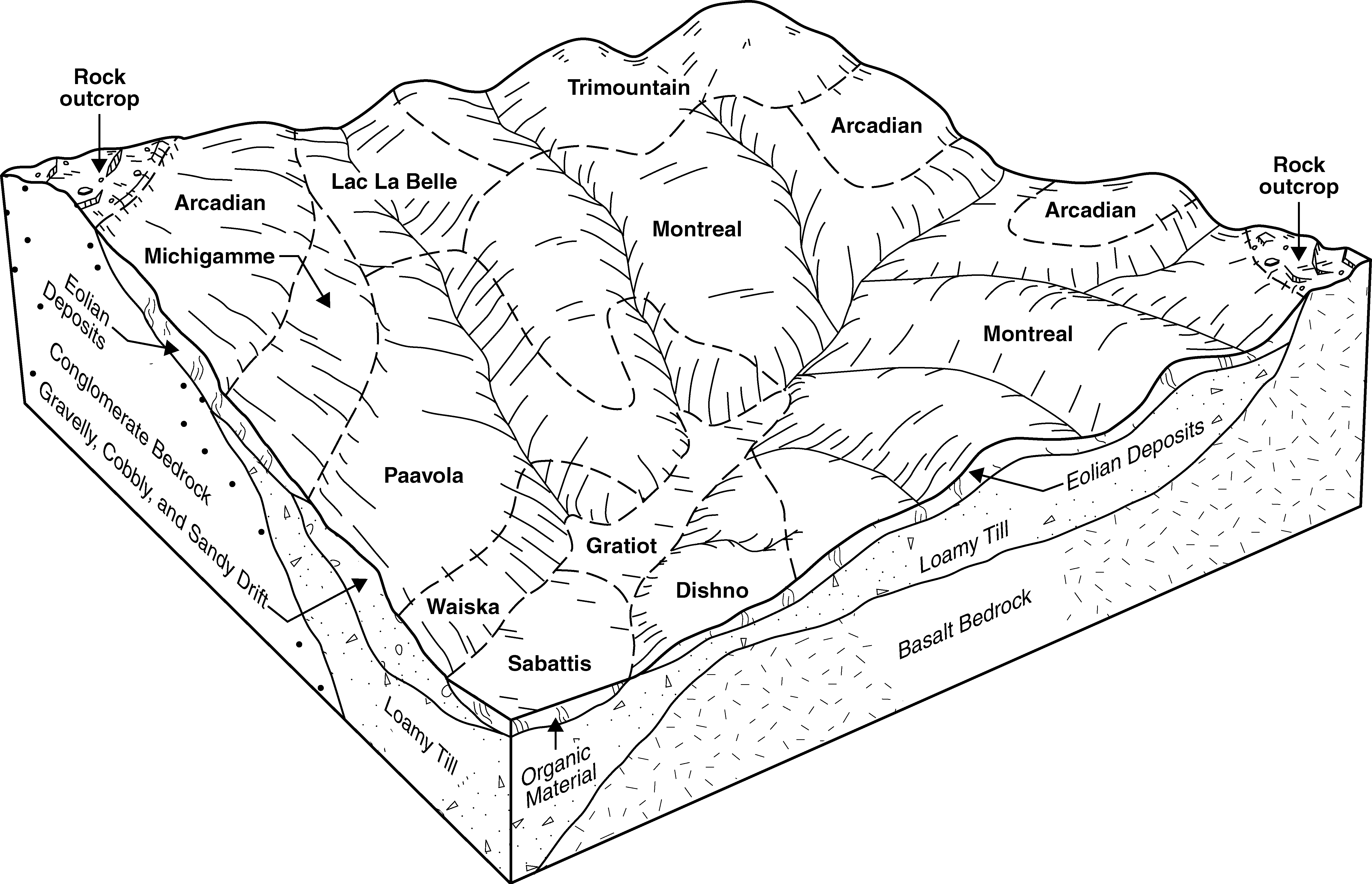
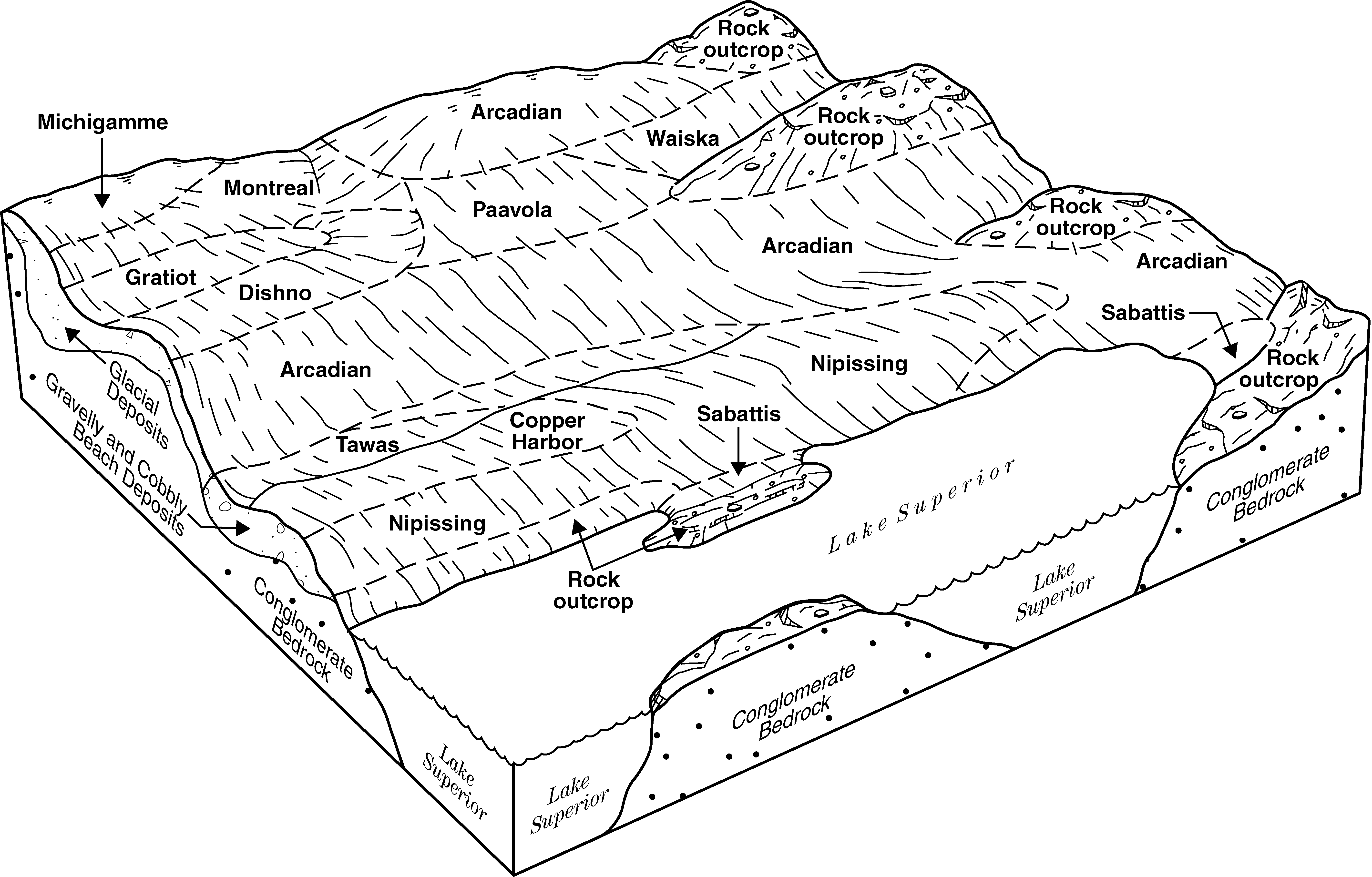
Montreal-Paavola-Michigamme complex, dissected, 1 to 12 percent slopes, rocky | 116B | 4899 | 416053 | fyy2 | mi061 | 1989 | 1:20000 |
Karlin-Michigamme complex, 2 to 18 percent slopes, rocky | 8048C | 1947 | 2485990 | 2pfw7 | mi061 | 1989 | 1:20000 |
Trimountain-Paavola-Michigamme complex, dissected, 8 to 35 percent slopes, rocky | 116D | 1307 | 416054 | fyy3 | mi061 | 1989 | 1:20000 |
Arcadian-Michigamme-Rock outcrop complex, 1 to 8 percent slopes | 92B | 968 | 416174 | fz1z | mi061 | 1989 | 1:20000 |
Trimountain-Paavola-Michigamme complex, dissected, 15 to 60 percent slopes, rocky | 116E | 924 | 416055 | fyy4 | mi061 | 1989 | 1:20000 |
Michigamme-Net complex, 0 to 8 percent slopes, rocky | 136B | 687 | 416075 | fyys | mi061 | 1989 | 1:20000 |
Arcadian-Michigamme-Rock outcrop complex, 8 to 15 percent slopes | 92D | 361 | 416175 | fz20 | mi061 | 1989 | 1:20000 |
Arcadian-Michigamme-Rock outcrop complex, 15 to 35 percent slopes | 92E | 261 | 416176 | fz21 | mi061 | 1989 | 1:20000 |
Karlin-Michigamme complex, 18 to 35 percent slopes, very rocky | 8048D | 201 | 2485991 | 2pfw8 | mi061 | 1989 | 1:20000 |
Karlin-Michigamme complex, 25 to 75 percent slopes, very rocky | 8048F | 189 | 2485993 | 2pfwb | mi061 | 1989 | 1:20000 |
Michigamme-Schweitzer-Peshekee-Rock outcrop complex, 55 to 75 percent slopes, very stony | 8369F | 132 | 2485821 | 2pfps | mi061 | 1989 | 1:20000 |
Michigamme-Schweitzer-Peshekee-Rock outcrop complex, 35 to 55 percent slopes, very stony | 8369E | 3 | 2497545 | 1t6xc | mi061 | 1989 | 1:20000 |
Karlin-Michigamme complex, 2 to 18 percent slopes, rocky | 48C | 574 | 2452560 | 2nb2v | mi071 | 1992 | 1:20000 |
Karlin-Michigamme complex, 25 to 75 percent slopes, very rocky | 48F | 180 | 2452561 | 2nb2w | mi071 | 1992 | 1:20000 |
Michigamme-Rock outcrop complex, 25 to 70 percent slopes, very bouldery | 55F | 40476 | 395231 | f88d | mi103 | 1999 | 1:24000 |
Keewaydin-Michigamme-Rock outcrop complex, 6 to 25 percent slopes, very bouldery | 112D | 29775 | 394980 | f809 | mi103 | 1999 | 1:24000 |
Dishno-Michigamme-Rock outcrop complex, 6 to 25 percent slopes, very bouldery | 207D | 21272 | 395165 | f868 | mi103 | 1999 | 1:24000 |
Keewaydin-Michigamme-Rock outcrop complex, 25 to 60 percent slopes, very bouldery | 112F | 20354 | 394982 | f80c | mi103 | 1999 | 1:24000 |
Keewaydin-Michigamme cobbly fine sandy loams, 18 to 45 percent slopes, rocky, very bouldery | 208F | 4324 | 395166 | f869 | mi103 | 1999 | 1:24000 |
Schweitzer-Michigamme-Rock outcrop complex, 25 to 60 percent slopes, very stony | 74F | 4310 | 395263 | f89f | mi103 | 1999 | 1:24000 |
Schweitzer-Michigamme-Rock outcrop complex, 6 to 25 percent slopes, very stony | 74D | 3273 | 395261 | f89c | mi103 | 1999 | 1:24000 |
Schweitzer-Michigamme complex, 18 to 35 percent slopes, rocky, very stony | 179E | 554 | 395134 | f858 | mi103 | 1999 | 1:24000 |
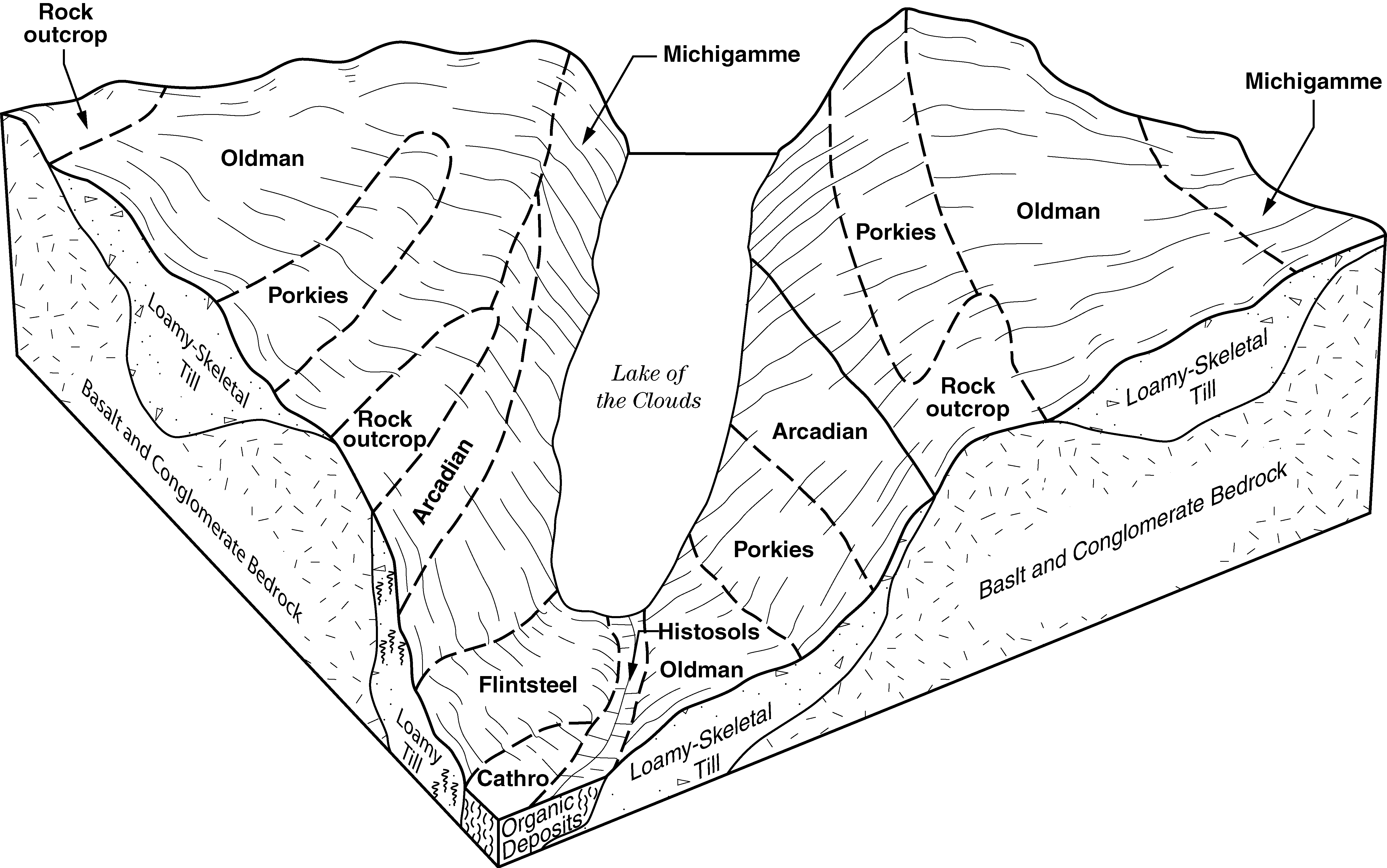
Oldman-Michigamme-Rock outcrop complex, 6 to 35 percent slopes, very bouldery | 31E | 3068 | 1456410 | 1kwhz | mi131 | 2007 | 1:24000 |
Arcadian-Michigamme-Rock outcrop complex, 35 to 70 percent slopes, extremely bouldery | 15F | 1780 | 1456397 | 1kwhk | mi131 | 2007 | 1:24000 |
Michigamme-Rock outcrop complex, 15 to 35 percent slopes, very bouldery | 61E | 1520 | 1456462 | 1kwkn | mi131 | 2007 | 1:24000 |
Michigamme-Rock outcrop complex, 35 to 70 percent slopes, very bouldery | 61F | 1439 | 1456463 | 1kwkp | mi131 | 2007 | 1:24000 |
Michigamme-Schweitzer-Peshekee-Rock outcrop complex, 35 to 55 percent slopes, very stony | 8369E | 1087 | 1674941 | 1t6xc | mi131 | 2007 | 1:24000 |
Karlin-Michigamme complex, 2 to 18 percent slopes, rocky | 8048C | 923 | 1674517 | 1t6gp | mi131 | 2007 | 1:24000 |
Arcadian-Michigamme-Rock outcrop complex, 15 to 35 percent slopes, extremely bouldery | 15E | 778 | 1456396 | 1kwhj | mi131 | 2007 | 1:24000 |
Michigamme-Schweitzer-Peshekee-Rock outcrop complex, 55 to 75 percent slopes, very stony | 8369F | 674 | 1674942 | 1t6xd | mi131 | 2007 | 1:24000 |
Arcadian-Michigamme-Rock outcrop complex, 6 to 15 percent slopes, extremely bouldery | 15D | 287 | 1456395 | 1kwhh | mi131 | 2007 | 1:24000 |
Karlin-Michigamme complex, 18 to 35 percent slopes, very rocky | 8048D | 31 | 1674518 | 1t6gq | mi131 | 2007 | 1:24000 |
Arcadian-Michigamme-Rock outcrop complex, 35 to 70 percent slopes, extremely bouldery | 53F | 9075 | 435353 | gm0n | mi605 | 2004 | 1:24000 |
Trimountain-Lac La Belle-Michigamme complex, dissected, 15 to 60 percent slopes, very rocky, extremely bouldery | 162F | 3832 | 435394 | gm1z | mi605 | 2004 | 1:24000 |
Arcadian-Michigamme-Rock outcrop complex, 8 to 35 percent slopes, extremely bouldery | 53E | 1667 | 435351 | gm0l | mi605 | 2004 | 1:24000 |
Michigamme-Peshekee-Rock outcrop complex, 4 to 26 percent slopes, very stony | 76E | 10526 | 2438014 | 2mtym | mi606 | | 1:12000 |
Michigamme-Peshekee complex, 5 to 21 percent slopes, very rocky, stony | 13D | 7807 | 1717908 | 1vnmd | mi606 | | 1:12000 |
Michigamme-Peshekee-Arcadian complex, 5 to 33 percent slopes, very rocky | 71E | 7593 | 2438006 | 2mtyc | mi606 | | 1:12000 |
Chippewa Harbor-Michigamme complex, 3 to 19 percent slopes, rocky | 70D | 4553 | 2438004 | 2mty9 | mi606 | | 1:12000 |
Michigamme-Peshekee complex, 7 to 35 percent slopes, very rocky, stony | 13E | 4440 | 1717906 | 1vnmb | mi606 | | 1:12000 |
Montreal-Michigamme complex, 3 to 17 percent slopes, rocky, very stony | 63D | 3511 | 2378257 | 2ktrz | mi606 | | 1:12000 |
Michigamme-Arcadian complex, 9 to 45 percent slopes, rocky, very stony | 12E | 2516 | 1717902 | 1vnm6 | mi606 | | 1:12000 |
Michigamme-Peshekee-Arcadian complex, 3 to 19 percent slopes, very rocky | 71D | 2131 | 2438005 | 2mtyb | mi606 | | 1:12000 |
Trimountain-Michigamme complex, 7 to 27 percent slopes, rocky, very stony | 51E | 1795 | 2378226 | 2ktqz | mi606 | | 1:12000 |
Arcadian-Michigamme-Peshekee complex, 6 to 38 percent slopes, very rocky, very stony | 77E | 1482 | 2438015 | 2mtyn | mi606 | | 1:12000 |
Michigamme-Peshekee complex, 10 to 58 percent slopes, very rocky, stony | 13F | 1375 | 1717909 | 1vnmf | mi606 | | 1:12000 |
Michigamme-Peshekee complex, 3 to 13 percent slopes, very rocky, stony | 13C | 1353 | 2377684 | 2kt5h | mi606 | | 1:12000 |
Arcadian-Michigamme complex, 9 to 59 percent slopes, rocky, very stony | 12F | 1033 | 2377677 | 2kt58 | mi606 | | 1:12000 |
Michigamme-Quetico-Rock outcrop complex, 5 to 35 percent slopes, very stony | 81F | 452 | 2438022 | 2mtyw | mi606 | | 1:12000 |
Michigamme-Sturgeon, occasionally flooded, complex, 0 to 46 percent slopes | 54E | 197 | 2378229 | 2ktr2 | mi606 | | 1:12000 |
Michigamme-Schweitzer-Peshekee-Rock outcrop complex, 35 to 55 percent slopes, very stony | 5369F | 593 | 1702870 | 1v4z9 | wi003 | 2006 | 1:12000 |
Michigamme-Schweitzer-Peshekee-Rock outcrop complex, 55 to 75 percent slopes, very stony | 5369G | 69 | 1702871 | 1v4zb | wi003 | 2006 | 1:12000 |
Michigamme-Schweitzer-Peshekee-Rock outcrop complex, 35 to 55 percent slopes, very stony | 5369F | 2240 | 1532161 | 1nfbk | wi051 | 2006 | 1:12000 |
Michigamme-Channing complex, 0 to 6 percent slopes, very stony, rocky | 5541B | 1817 | 1532192 | 1nfck | wi051 | 2006 | 1:12000 |
Michigamme-Schweitzer-Peshekee-Rock outcrop complex, 55 to 75 percent slopes, very stony | 5369G | 1378 | 1701226 | 1v388 | wi051 | 2006 | 1:12000 |
Gogebic-Michigamme-Rock outcrop complex, 6 to 35 percent slopes, very stony | 5432E | 671 | 1532171 | 1nfbw | wi051 | 2006 | 1:12000 |
Gogebic-Michigamme-Rock outcrop complex, 6 to 18 percent slopes, very stony | 5432D | 555 | 1532170 | 1nfbv | wi051 | 2006 | 1:12000 |
Michigamme-Channing complex, 0 to 18 percent slopes, very stony, rocky | 5541C | 352 | 1532193 | 1nfcl | wi051 | 2006 | 1:12000 |
Schweitzer-Michigamme-Rock outcrop complex, very stony, 18 to 55 percent slopes | 5469F | 258 | 1700784 | 1v2t0 | wi051 | 2006 | 1:12000 |
Michigamme-Rock outcrop complex, 4 to 15 percent slopes | 3541C | 25099 | 422423 | g5kk | wi075 | 1987 | 1:20000 |
