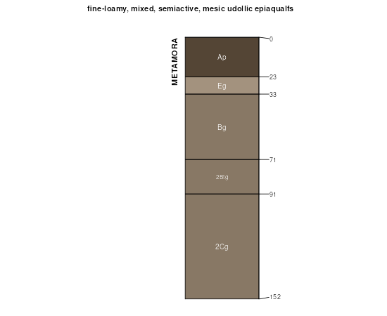
| Metamora fine sandy loam, moderately permeable, 1 to 4 percent slopes | MeB | 1010 | 161363 | 5dx8 | in073 | 1985 | 1:15840 |
Metamora fine sandy loam, moderately permeable, 0 to 1 percent slopes | MeA | 851 | 161362 | 5dx7 | in073 | 1985 | 1:15840 |
Metamora sandy loam, 1 to 4 percent slopes | 42B | 5117 | 212463 | 742n | mi005 | 1984 | 1:15840 |
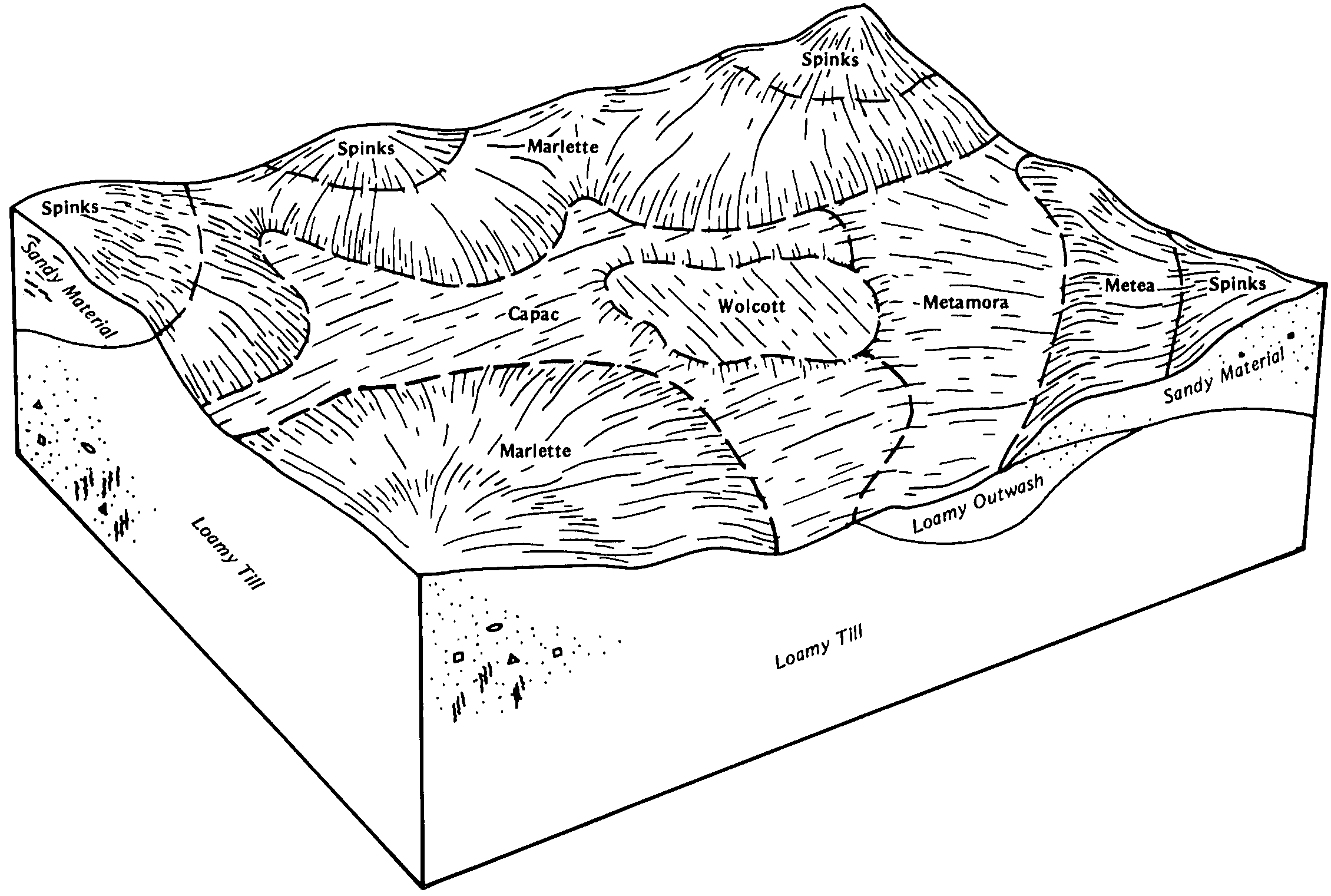
Metamora-Capac sandy loams, 0 to 4 percent slopes | MeA | 9622 | 186385 | 67yf | mi037 | 1974 | 1:15840 |
Metamora-Conover complex, 0 to 3 percent slopes | MetaaA | 3966 | 3117298 | 2y14m | mi037 | 1974 | 1:15840 |
Metamora-Capac sandy loams, 0 to 4 percent slopes | MeA | 6858 | 186242 | 67st | mi045 | 1974 | 1:15840 |
Metamora sandy loam, 0 to 2 percent slopes | MlA | 5909 | 186866 | 68fy | mi049 | 1967 | 1:20000 |
Conover-Metamora sandy loams, 0 to 2 percent slopes | CwA | 4780 | 186843 | 68f6 | mi049 | 1967 | 1:20000 |
Conover-Metamora sandy loams, 2 to 6 percent slopes | CwB | 3782 | 186844 | 68f7 | mi049 | 1967 | 1:20000 |
Metamora-Conover complex, 0 to 3 percent slopes | MetaaA | 1786 | 3117293 | 2y14m | mi049 | 1967 | 1:20000 |
Metamora sandy loam, 2 to 6 percent slopes | MlB | 1462 | 186867 | 68fz | mi049 | 1967 | 1:20000 |
Urban land-Metamora-Udorthents complex, 0 to 3 percent slopes | UrbagA | 154 | 1905440 | 21yrt | mi049 | 1967 | 1:20000 |
Metamora sandy loam, 0 to 4 percent slopes | MiB | 34 | 2423849 | 2mc6p | mi049 | 1967 | 1:20000 |
Metamora loamy sand, 0 to 2 percent slopes | MrA | 1 | 2424285 | 2mcnr | mi049 | 1967 | 1:20000 |
Metamora-Conover complex, 0 to 3 percent slopes | MetaaA | 9420 | 3117287 | 2y14m | mi057 | 1975 | 1:12000 |
Metamora-Capac sandy loams, 0 to 2 percent slopes | MeA | 8982 | 187022 | 68lz | mi057 | 1975 | 1:12000 |
Metamora sandy loam, 2 to 6 percent slopes | MsB | 3 | 2437773 | 2mtpv | mi065 | 1977 | 1:15840 |
Metamora sandy loam, 2 to 6 percent slopes | MsB | 792 | 188100 | 69qr | mi067 | 1965 | 1:15840 |
Metamora sandy loam, 0 to 2 percent slopes | MsA | 569 | 188099 | 69qq | mi067 | 1965 | 1:15840 |
Metamora fine sandy loam, 0 to 3 percent slopes | 26A | 2672 | 186617 | 685x | mi073 | 1983 | 1:15840 |
Metamora-Conover complex, 0 to 3 percent slopes | MetaaA | 63 | 3117275 | 2y14m | mi073 | 1983 | 1:15840 |
Metamora sandy loam, 0 to 3 percent slopes | 13A | 5232 | 187100 | 68ph | mi081 | 1984 | 1:15840 |
Metamora sandy loam, 0 to 2 percent slopes | MnA | 662 | 192089 | 6fwf | mi087 | 1966 | 1:15840 |
Metamora sandy loam, 2 to 6 percent slopes | MnB | 385 | 192090 | 6fwg | mi087 | 1966 | 1:15840 |
Conover-Metamora sandy loams, 2 to 6 percent slopes | CwB | 1 | 2420033 | 2m77l | mi087 | 1966 | 1:15840 |
Metamora sandy loam, 0 to 3 percent slopes | MmA | 117 | 2508743 | 68ts | mi091 | 1957 | 1:20000 |
Metamora-Corunna sandy loams, 0 to 3 percent slopes | MnA | 73 | 2508744 | 68tl | mi091 | 1957 | 1:20000 |
Metamora sandy loam, 0 to 4 percent slopes | MlA | 12 | 2508742 | 6ff3 | mi091 | 1957 | 1:20000 |
Metamora sandy loam, 0 to 4 percent slopes | MlB | 4027 | 187579 | 695y | mi093 | 1968 | 1:20000 |
Metamora sandy loam, 0 to 2 percent slopes | MeA | 52 | 2441837 | 2myxy | mi093 | 1968 | 1:20000 |
Metamora sandy loam, 2 to 6 percent slopes | MeB | 37 | 2440082 | 2mx3b | mi093 | 1968 | 1:20000 |
Metamora fine sandy loam, 0 to 2 percent slopes | MeA | 2798 | 187662 | 698m | mi099 | 1967 | 1:20000 |
Del Rey-Metamora sandy loams, 0 to 2 percent slopes | DmA | 1972 | 187636 | 697s | mi099 | 1967 | 1:20000 |
Metamora fine sandy loam, 2 to 6 percent slopes | MeB | 401 | 187663 | 698n | mi099 | 1967 | 1:20000 |
Del Rey-Metamora sandy loams, 2 to 6 percent slopes | DmB | 238 | 187637 | 697t | mi099 | 1967 | 1:20000 |
Metamora sandy loam, 0 to 3 percent slopes | MfA | 13 | 2508530 | 6bhm | mi099 | 1967 | 1:20000 |
Metamora sandy loam, 0 to 2 percent slopes | MgA | 3 | 2508531 | 6913 | mi099 | 1967 | 1:20000 |
Metamora-Conover complex, 0 to 3 percent slopes | MetaaA | 108 | 3117262 | 2y14m | mi111 | 1976 | 1:15840 |
Metamora sandy loam, 0 to 3 percent slopes | 23A | 9738 | 187233 | 68ts | mi115 | 1980 | 1:15840 |
Metamora-Corunna sandy loams, 0 to 3 percent slopes | 17A | 5657 | 187227 | 68tl | mi115 | 1980 | 1:15840 |
Blount-Pewamo-Metamora complex, 0 to 3 percent slopes | 62A | 2378 | 187267 | 68vw | mi115 | 1980 | 1:15840 |
Metamora sandy loam, 0 to 3 percent slopes | 36A | 2952 | 188840 | 6bhm | mi125 | 1980 | 1:15840 |
Del Rey-Metamora sandy loams, 0 to 2 percent slopes | 127A | 22 | 2508678 | 697s | mi125 | 1980 | 1:15840 |
Metamora sandy loam, 0 to 2 percent slopes | 143A | 12 | 2673697 | 6fwf | mi125 | 1980 | 1:15840 |
Conover-Metamora sandy loams, 2 to 6 percent slopes | 110B | 9 | 2438229 | 2mv5k | mi125 | 1980 | 1:15840 |
Metamora sandy loam, 2 to 6 percent slopes | MnB | 1073 | 192693 | 6ghx | mi139 | 1967 | 1:15840 |
Metamora sandy loam, 0 to 2 percent slopes | MnA | 906 | 192692 | 6ghw | mi139 | 1967 | 1:15840 |
Metamora sandy loam, 0 to 2 percent slopes | 117A | 78 | 2399412 | 2ljsd | mi145 | 1991 | 1:15840 |
Metamora-Conover complex, 0 to 3 percent slopes | MetaaA | 24 | 3117254 | 2y14m | mi145 | 1991 | 1:15840 |
Metamora sandy loam, 2 to 6 percent slopes | 117B | 19 | 2399408 | 2ljs8 | mi145 | 1991 | 1:15840 |
Metamora-Parkhill complex, 0 to 2 percent slopes | MhA | 8135 | 187431 | 6915 | mi147 | 1969 | 1:20000 |
Metamora sandy loam, 0 to 2 percent slopes | MeA | 6381 | 187429 | 6913 | mi147 | 1969 | 1:20000 |
Metamora sandy loam, 2 to 6 percent slopes | MeB | 1267 | 187430 | 6914 | mi147 | 1969 | 1:20000 |
Metamora fine sandy loam, 0 to 2 percent slopes | MaA | 270 | 2508375 | 698m | mi147 | 1969 | 1:20000 |
Metamora fine sandy loam, 2 to 6 percent slopes | MaB | 17 | 2508376 | 698n | mi147 | 1969 | 1:20000 |
Metamora sandy loam, 0 to 4 percent slopes | MvB | 79 | 2508300 | 692b | mi151 | 1955 | 1:15840 |
Metamora sandy loam, 0 to 2 percent slopes | MlA | 12 | 2508288 | 6913 | mi151 | 1955 | 1:15840 |
Metamora sandy loam, 2 to 6 percent slopes | MsB | 4786 | 187832 | 69g3 | mi155 | 1967 | 1:12000 |
Metamora sandy loam, 0 to 2 percent slopes | MsA | 2981 | 187831 | 69g2 | mi155 | 1967 | 1:12000 |
Metamora loamy sand, 0 to 2 percent slopes | MrA | 850 | 187830 | 69g1 | mi155 | 1967 | 1:12000 |
Metamora-Conover complex, 0 to 3 percent slopes | MetaaA | 263 | 3117246 | 2y14m | mi155 | 1967 | 1:12000 |
Metamora-Capac sandy loams, 0 to 4 percent slopes | MqA | 74 | 2399158 | 2ljj6 | mi155 | 1967 | 1:12000 |
Conover-Metamora sandy loams, 0 to 2 percent slopes | CwA | 7 | 2399238 | 2ljls | mi155 | 1967 | 1:12000 |
Metamora sandy loam, 0 to 4 percent slopes | 11B | 8684 | 187467 | 692b | mi157 | 1984 | 1:15840 |
Metamora-Conover complex, 0 to 3 percent slopes | MetaaA | 298 | 3117243 | 2y14m | mi157 | 1984 | 1:15840 |
Metamora sandy loam, 0 to 2 percent slopes | 144A | 4 | 2508145 | 6fwf | mi157 | 1984 | 1:15840 |
Metamora sandy loam, 2 to 6 percent slopes | 144B | 2 | 2508146 | 6fwg | mi157 | 1984 | 1:15840 |
Metamora sandy loam, 0 to 4 percent slopes | MfA | 1788 | 191645 | 6ff3 | mi161 | 1974 | 1:20000 |
Metamora sandy loam, 0 to 3 percent slopes | MgA | 208 | 2508713 | 68ts | mi161 | 1974 | 1:20000 |
Metamora sandy loam, 0 to 3 percent slopes | MeA | 7966 | 3015050 | 6bkj | mi163 | 1974 | 1:12000 |
Metamora-Pewamo complex, 0 to 3 percent slopes | MfA | 1447 | 3015051 | 6bkk | mi163 | 1974 | 1:12000 |
Metamora sandy loam, 0 to 3 percent slopes | MmA | 2992 | 169855 | 5pr6 | oh095 | 1978 | 1:15840 |
