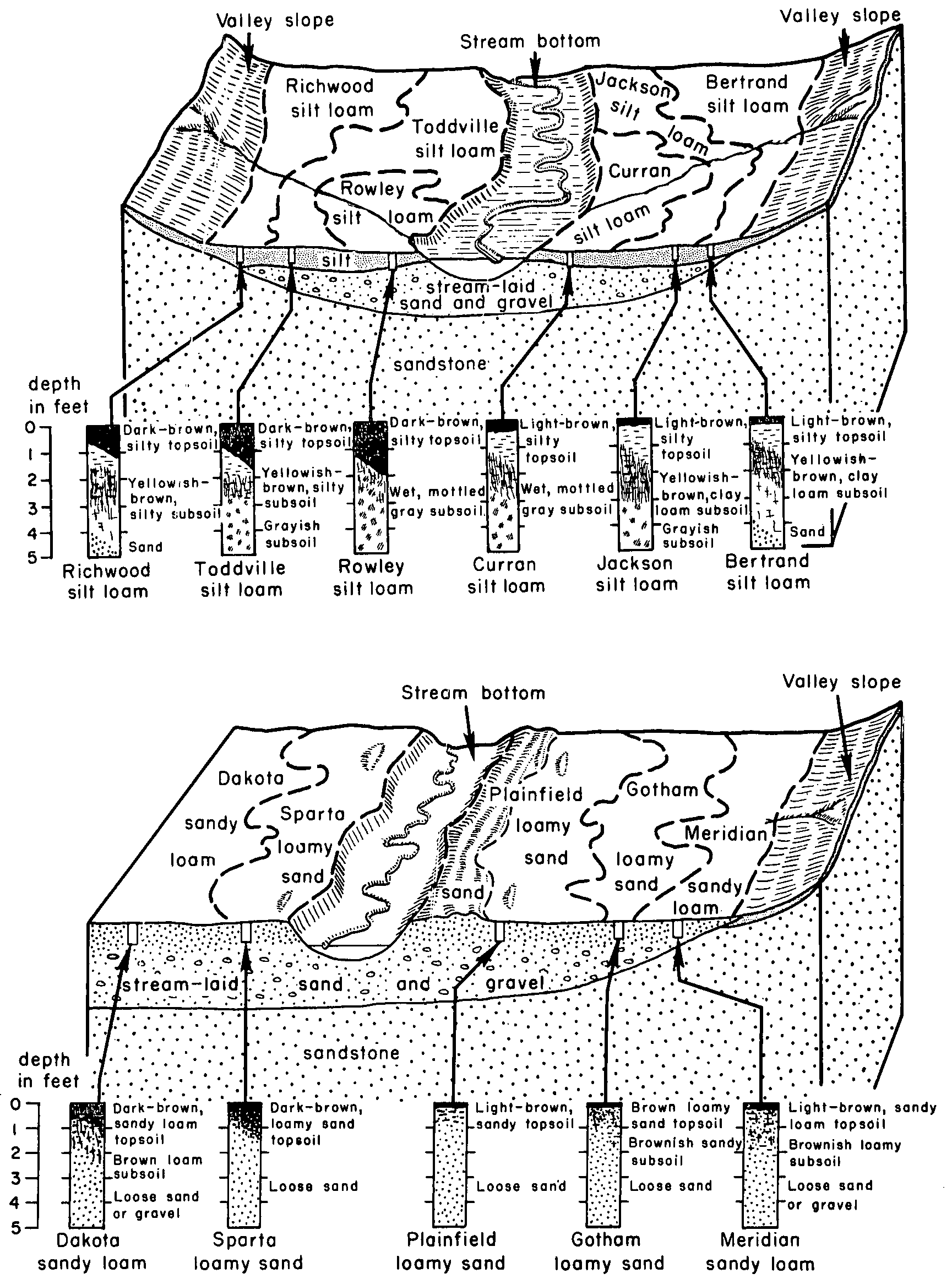
| Meridian loam, 0 to 3 percent slopes | M513A | 1120 | 1384957 | 1hh51 | mn039 | 2005 | 1:12000 |
Meridian fine sandy loam, 2 to 6 percent slopes | Mc | 473 | 2216759 | 2ddqc | mn045 | 2008 | 1:12000 |
Meridian silt loam, 0 to 3 percent slopes | N607A | 1956 | 1670219 | 1t201 | mn049 | 2007 | 1:12000 |
Meridian silt loam, 6 to 12 percent slopes, moderately eroded | N607C2 | 444 | 1690744 | 1trc4 | mn049 | 2007 | 1:12000 |
Meridian, till substratum-Bassett complex, 6 to 12 percent slopes, moderately eroded | M536C2 | 411 | 1670153 | 1t1xx | mn049 | 2007 | 1:12000 |
Meridian, till substratum-Bassett complex, 12 to 18 percent slopes, moderately eroded | M536D2 | 337 | 1670154 | 1t1xy | mn049 | 2007 | 1:12000 |
Meridian silt loam, 12 to 18 percent slopes, moderately eroded | N607D2 | 242 | 1690743 | 1trc3 | mn049 | 2007 | 1:12000 |
Meridian-Bassett complex, 18 to 35 percent slopes | M537E | 139 | 1670173 | 1t1yk | mn049 | 2007 | 1:12000 |
Meridian sandy loam, 2 to 6 percent slopes | MdB | 528 | 2216396 | 2ddbn | mn157 | 2008 | 1:12000 |
Meridian sandy loam, 0 to 2 percent slopes | MdA | 507 | 2216395 | 2ddbm | mn157 | 2008 | 1:12000 |
Meridian sandy loam, 6 to 12 percent slopes, moderately eroded | MdC2 | 155 | 2216399 | 2ddbr | mn157 | 2008 | 1:12000 |
Meridian silt loam, 2 to 6 percent slopes, moderately eroded | 423B2 | 232 | 2561787 | 1vgbf | wi011 | 1960 | 1:12000 |
Meridian silt loam, 0 to 3 percent slopes | 423A | 197 | 2639462 | 1vgbd | wi011 | 1960 | 1:12000 |
Meridian silt loam, 6 to 12 percent slopes, moderately eroded | 423C2 | 51 | 2561786 | g0w1 | wi011 | 1960 | 1:12000 |
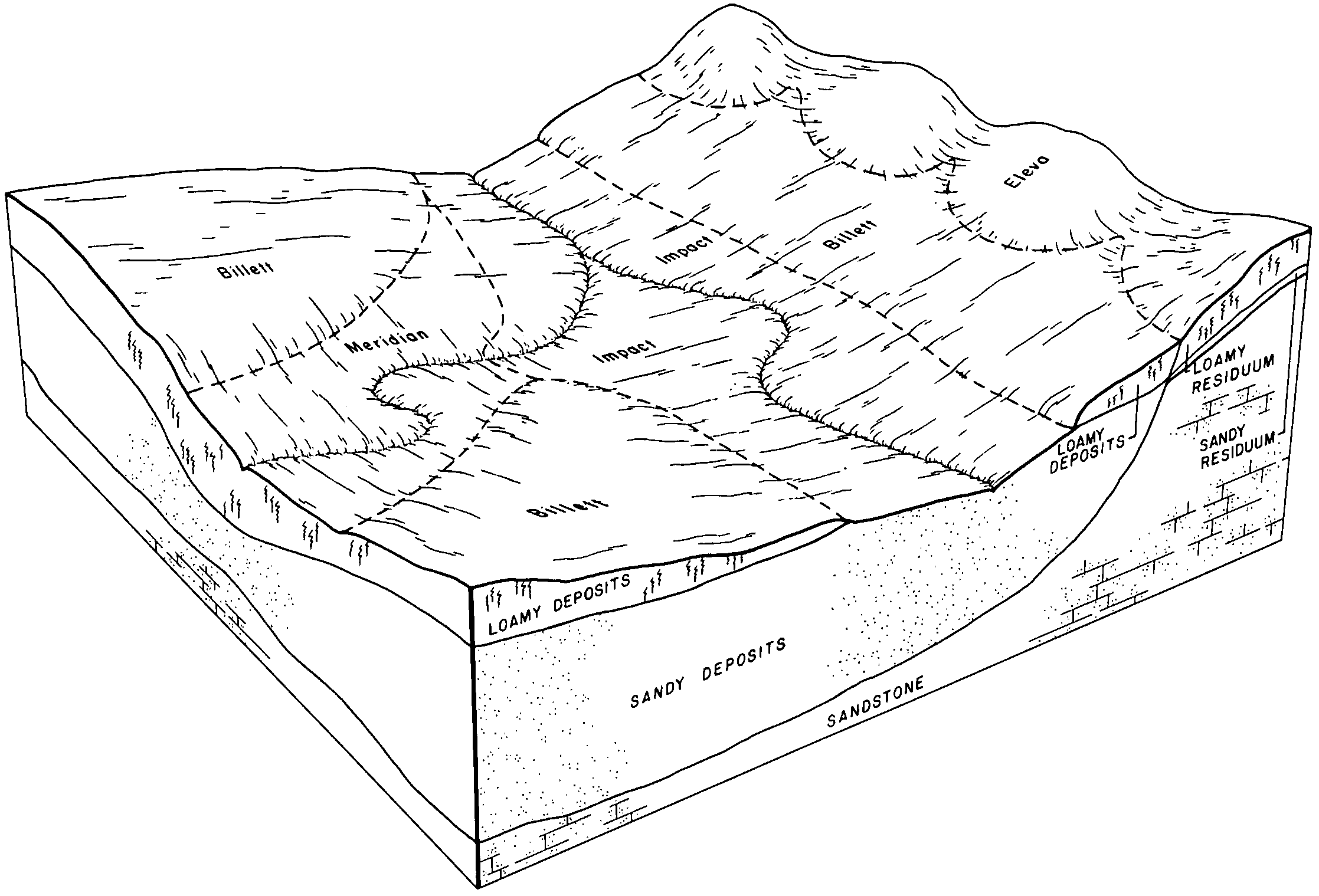
Meridian loam, 2 to 6 percent slopes | 423B | 4217 | 421554 | g4nj | wi017 | 1985 | 1:15840 |
Meridian loam, moderately well drained, 0 to 3 percent slopes | 416A | 1993 | 421555 | g4nk | wi017 | 1985 | 1:15840 |
Meridian loam, 0 to 2 percent slopes | 423A | 1618 | 421553 | g4nh | wi017 | 1985 | 1:15840 |
Meridian silt loam, 2 to 6 percent slopes, moderately eroded | 423B2 | 131 | 2504048 | 1vgbf | wi023 | 1960 | 1:12000 |
Meridian silt loam, 0 to 3 percent slopes | 423A | 29 | 2504045 | 1vgbd | wi023 | 1960 | 1:12000 |
Meridian silt loam, 6 to 12 percent slopes, moderately eroded | 423C2 | 17 | 2504052 | g0w1 | wi023 | 1960 | 1:12000 |
Meridian loam, 0 to 2 percent slopes | 423A | 1631 | 753539 | t93q | wi025 | 1972 | 1:15840 |
Meridian loam, 2 to 6 percent slopes | 423B | 1315 | 753540 | t93r | wi025 | 1972 | 1:15840 |
Meridian silt loam, 0 to 3 percent slopes | 423A | 1452 | 2504046 | 1vgbd | wi033 | 2003 | 1:12000 |
Meridian silt loam, 2 to 6 percent slopes, moderately eroded | 423B2 | 1122 | 2504049 | 1vgbf | wi033 | 2003 | 1:12000 |
Meridian silt loam, 6 to 12 percent slopes, moderately eroded | 423C2 | 10 | 2504053 | g0w1 | wi033 | 2003 | 1:12000 |
Meridian silt loam, 2 to 6 percent slopes, moderately eroded | 423B2 | 4797 | 3099704 | 1vgbf | wi035 | 1974 | 1:12000 |
Meridian silt loam, 0 to 3 percent slopes | 423A | 2041 | 3099703 | 1vgbd | wi035 | 1974 | 1:12000 |
Meridian silt loam, 6 to 12 percent slopes, moderately eroded | 423C2 | 1732 | 3099644 | g0w1 | wi035 | 1974 | 1:12000 |
Meridian fine sandy loam, 2 to 6 percent slopes, moderately eroded | 490B2 | 337 | 424301 | g7j4 | wi043 | 1959 | 1:20000 |
Meridian fine sandy loam, 10 to 15 percent slopes, moderately eroded | 490D2 | 274 | 424304 | g7j7 | wi043 | 1959 | 1:20000 |
Meridian fine sandy loam, 0 to 2 percent slopes | 490A | 260 | 424299 | g7j2 | wi043 | 1959 | 1:20000 |
Meridian loam, 2 to 6 percent slopes | 423B | 215 | 424306 | g7j9 | wi043 | 1959 | 1:20000 |
Meridian loam, 0 to 2 percent slopes | 423A | 205 | 424305 | g7j8 | wi043 | 1959 | 1:20000 |
Meridian fine sandy loam, 6 to 10 percent slopes, moderately eroded | 490C2 | 181 | 424302 | g7j5 | wi043 | 1959 | 1:20000 |
Meridian loam, 2 to 6 percent slopes, moderately eroded | 423B2 | 141 | 424307 | g7jb | wi043 | 1959 | 1:20000 |
Meridian fine sandy loam, 2 to 6 percent slopes | 490B | 119 | 424300 | g7j3 | wi043 | 1959 | 1:20000 |
Meridian loam, 10 to 15 percent slopes, moderately eroded | 423D2 | 33 | 424309 | g7jd | wi043 | 1959 | 1:20000 |
Meridian loam, 6 to 10 percent slopes, moderately eroded | 423C2 | 23 | 424308 | g7jc | wi043 | 1959 | 1:20000 |
Meridian loam, 2 to 6 percent slopes, moderately eroded | 423B2 | 1047 | 425301 | g8kd | wi045 | 1969 | 1:12000 |
Meridian loam, 0 to 2 percent slopes | 423A | 616 | 425300 | g8kc | wi045 | 1969 | 1:12000 |
Meridian loam, 6 to 12 percent slopes, moderately eroded | 423C2 | 244 | 425302 | g8kf | wi045 | 1969 | 1:12000 |
Meridian silt loam, 2 to 6 percent slopes, moderately eroded | 423B2 | 261 | 2774824 | 1vgbf | wi049 | 1960 | 1:20000 |
Meridian silt loam, 0 to 3 percent slopes | 423A | 181 | 2774823 | 1vgbd | wi049 | 1960 | 1:20000 |
Meridian silt loam, 6 to 12 percent slopes, moderately eroded | 423C2 | 95 | 2774809 | g0w1 | wi049 | 1960 | 1:20000 |
Meridian loam, 2 to 6 percent slopes | 423B | 193 | 424847 | g82r | wi065 | 1964 | 1:15840 |
Meridian sandy loam, 2 to 6 percent slopes | 436B | 142 | 424849 | g82t | wi065 | 1964 | 1:15840 |
Meridian loam, 0 to 2 percent slopes | 423A | 99 | 424846 | g82q | wi065 | 1964 | 1:15840 |
Meridian sandy loam, 0 to 2 percent slopes | 436A | 43 | 424848 | g82s | wi065 | 1964 | 1:15840 |
Meridian silt loam, 0 to 3 percent slopes | 423A | 750 | 2504047 | 1vgbd | wi091 | 1998 | 1:12000 |
Meridian silt loam, 2 to 6 percent slopes, moderately eroded | 423B2 | 502 | 2504050 | 1vgbf | wi091 | 1998 | 1:12000 |
Meridian silt loam, cobbly substratum, 0 to 2 percent slopes | 391A | 2097 | 1701118 | 1v34s | wi093 | 2006 | 1:12000 |
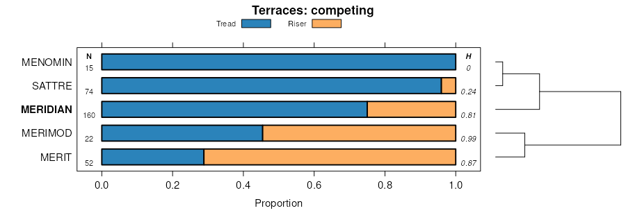
Meridian silt loam, strath terrace, 2 to 6 percent slopes, moderately eroded | 3300B2 | 842 | 1697578 | 1tzgl | wi093 | 2006 | 1:12000 |
Meridian silt loam, strath terrace, 0 to 2 percent slopes | 3300A | 315 | 1697577 | 1tzgk | wi093 | 2006 | 1:12000 |
Meridian silt loam, 2 to 6 percent slopes, moderately eroded | 423B2 | 300 | 1690951 | 1trkt | wi093 | 2006 | 1:12000 |
Meridian silt loam, strath terrace, 6 to 12 percent slopes, moderately eroded | 3300C2 | 174 | 1701124 | 1v34z | wi093 | 2006 | 1:12000 |
Meridian silt loam, 0 to 3 percent slopes | 423A | 73 | 1703595 | 1v5qp | wi093 | 2006 | 1:12000 |
Meridian silt loam, 6 to 12 percent slopes, moderately eroded | 423C2 | 12 | 1703596 | 1v5qq | wi093 | 2006 | 1:12000 |
Meridian silt loam, 2 to 6 percent slopes, moderately eroded | 423B2 | 113 | 2639542 | 1vgbf | wi121 | 1969 | 1:12000 |
Meridian silt loam, 0 to 3 percent slopes | 423A | 76 | 2639541 | 1vgbd | wi121 | 1969 | 1:12000 |
Meridian silt loam, 6 to 12 percent slopes, moderately eroded | 423C2 | 4 | 2683471 | g0w1 | wi121 | 1969 | 1:12000 |
Meridian silt loam, 6 to 12 percent slopes, moderately eroded | 423C2 | 11 | 2504054 | g0w1 | wi123 | 1965 | 1:12000 |
Meridian silt loam, 2 to 6 percent slopes, moderately eroded | 423B2 | 5 | 2504051 | 1vgbf | wi123 | 1965 | 1:12000 |
