Official Series Description


Lab Data Summary

Aggregate lab data for the MEADIN soil series. This aggregation is based on all pedons with a current taxon name of MEADIN, and applied along 1-cm thick depth slices. Solid lines are the slice-wise median, bounded on either side by the interval defined by the slice-wise 5th and 95th percentiles. The median is the value that splits the data in half. Five percent of the data are less than the 5th percentile, and five percent of the data are greater than the 95th percentile. Values along the right hand side y-axis describe the proportion of pedon data that contribute to aggregate values at this depth. For example, a value of "90%" at 25cm means that 90% of the pedons correlated to MEADIN were used in the calculation. Source: KSSL snapshot . Methods used to assemble the KSSL snapshot used by SoilWeb / SDE

Click the image to view it full size.

Pedons used in the lab summary:

MLRALab IDPedon IDTaxonnameCINSSL / NASIS ReportsLink To SoilWeb GMap
6640A2141S1969NE089002Meadin6Primary | Supplementary | Taxonomy | Pedon | Water Retention | Correlation | Andic Soil Properties42.5366554,-98.598999
6640A2142S1969NE103001Meadin6Primary | Supplementary | Taxonomy | Pedon | Water Retention | Correlation | Andic Soil Properties42.7930412,-99.7457047
7540A21401969NE095001Meadin5Primary | Supplementary | Taxonomy | Pedon | Water Retention | Correlation | Andic Soil Properties40.2294444,-97.295

Water Balance

Monthly water balance estimated using a leaky-bucket style model for the MEADIN soil series. Monthly precipitation (PPT) and potential evapotranspiration (PET) have been estimated from the 50th percentile of gridded values (PRISM 1981-2010) overlapping with the extent of SSURGO map units containing each series as a major component. Monthly PET values were estimated using the method of Thornthwaite (1948). These (and other) climatic parameters are calculated with each SSURGO refresh and provided by the fetchOSD function of the soilDB package. Representative water storage values (“AWC” in the figures) were derived from SSURGO by taking the 50th percentile of profile-total water storage (sum[awc_r * horizon thickness]) for each soil series. Note that this representation of “water storage” is based on the average ability of most plants to extract soil water between 15 bar (“permanent wilting point”) and 1/3 bar (“field capacity”) matric potential. Soil moisture state can be roughly interpreted as “dry” when storage is depleted, “moist” when storage is between 0mm and AWC, and “wet” when there is a surplus. Clearly there are a lot of assumptions baked into this kind of monthly water balance. This is still a work in progress.

Click the image to view it full size.


Click the image to view it full size.

Sibling Summary

Siblings are those soil series that occur together in map units, in this case with the MEADIN series. Sketches are arranged according to their subgroup-level taxonomic structure. Source: SSURGO snapshot , parsed OSD records and snapshot of SC database .

Click the image to view it full size.

Select annual climate data summaries for the MEADIN series and siblings. Series are sorted according to hierarchical clustering of median values. Source: SSURGO map unit geometry and 1981-2010, 800m PRISM data .

Click the image to view it full size.

Geomorphic description summaries for the MEADIN series and siblings. Series are sorted according to hierarchical clustering of proportions and relative hydrologic position within an idealized landform (e.g. top to bottom). Most soil series (SSURGO components) are associated with a hillslope position and one or more landform-specific positions: hills, mountain slopes, terraces, and/or flats. Proportions can be interpreted as an aggregate representation of geomorphic membership. The values printed to the left (number of component records) and right (Shannon entropy) of stacked bars can be used to judge the reliability of trends. Small Shannon entropy values suggest relatively consistent geomorphic association, while larger values suggest lack thereof. Source: SSURGO component records .

Click the image to view it full size.

Click the image to view it full size.

There are insufficient data to create the 3D mountains figure.

Click the image to view it full size.

Click the image to view it full size.

Competing Series

Soil series competing with MEADIN share the same family level classification in Soil Taxonomy. Source: parsed OSD records and snapshot of the SC database .

Click the image to view it full size.

Select annual climate data summaries for the MEADIN series and competing. Series are sorted according to hierarchical clustering of median values. Source: SSURGO map unit geometry and 1981-2010, 800m PRISM data .

Click the image to view it full size.

Geomorphic description summaries for the MEADIN series and competing. Series are sorted according to hierarchical clustering of proportions and relative hydrologic position within an idealized landform (e.g. top to bottom). Proportions can be interpreted as an aggregate representation of geomorphic membership. Most soil series (SSURGO components) are associated with a hillslope position and one or more landform-specific positions: hills, mountain slopes, terraces, and/or flats. The values printed to the left (number of component records) and right (Shannon entropy) of stacked bars can be used to judge the reliability of trends. Shannon entropy values close to 0 represent soil series with relatively consistent geomorphic association, while values close to 1 suggest lack thereof. Source: SSURGO component records .

Click the image to view it full size.

Click the image to view it full size.

There are insufficient data to create the 3D mountains figure.

Click the image to view it full size.

There are insufficient data to create the 3D flats position figure.

Soil series sharing subgroup-level classification with MEADIN, arranged according to family differentiae. Hovering over a series name will print full classification and a small sketch from the OSD. Source: snapshot of SC database .

Block Diagrams

Click a link below to display the diagram. Note that these diagrams may be from multiple survey areas.

  1. NE-2012-02-08-11 | Brown County - April 1992

    Typical pattern of soils and parent material in the Jansen-O'Neill-Meadin association (Soil Survey of Brown County, Nebraska; April 1992).

  2. NE-2012-02-10-13 | Clay County - March 1981

    Typical pattern of soils in the Geary-Holder-Uly and the Hord-Cass-Hobbs associations showing the relationship of the soils to topography and parent material (Soil Survey of Clay County, Nebraska; March 1981).

  3. NE-2012-02-13-30 | Holt County - March 1983

    Typical pattern of soils in the O'Neill-Meadin-Jansen association and their relationship to topography and parent material (Soil Survey of Holt County, Nebraska; March 1983).

  4. NE-2012-02-13-32 | Holt County - March 1983

    Typical pattern of soils in the Jansen-O'Neill association and their relationship to topography and parent material (Soil Survey of Holt County, Nebraska; March 1983).

  5. NE-2012-02-13-50 | Knox County - June 1997

    Typical pattern of soils and parent material in the Brunswick-Paka-Simeon association (Soil Survey of Knox County, Nebraska; June 1997).

  6. NE-2012-02-13-63 | Nance County - July 1960

    A cross section along the eastern side of Nance County showing the relationship of the soils to the geological materials (Soil Survey of Nance County, Nebraska; July 1960).

  7. NE-2012-02-14-07 | Thomas County - August 1965

    Diagram showing typical soils and parent materials in Thomas County. Symbols below soil names identify range sites as follows: (Sa) Sands; (CS) Choppy Sands; (Sy) Sandy; (Sb) Subirrigated; (WL) Wet Land; (TB) Thin Breaks; (SwG) Shallow to Gravel (Soil Survey of Thomas County, Nebraska; August 1965).

  8. SD-2012-03-15-35 | Gregory County - August 1984

    Pattern of soils and parent material in the Meadin-Jansen association (Soil Survey of Gregory County, SD; 1984).

Map Units

Map units containing MEADIN as a major component. Limited to 250 records.

Map Unit Name Symbol Map Unit Area (ac) Map Unit Key National Map Unit Symbol Soil Survey Area Publication Date Map Scale
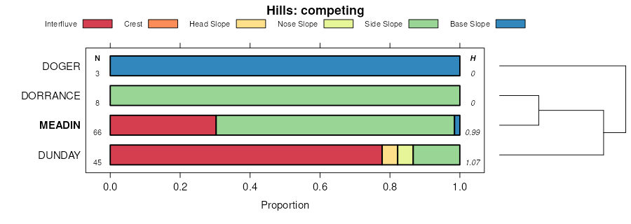
Meadin sandy loam, 3 to 15 percent slopes3898528613822252zt6lks05319851:24000
Meadin sandy loam, 0 to 2 percent slopes325227516919291tslcne00119701:20000
Meadin sandy loam, 2 to 30 percent slopes32552440426973gb9bne00319751:20000
Meadin sandy loam, 0 to 2 percent slopes3252245426972gb99ne00319751:20000
Meadin-Oneill complex, 2 to 30 percent slopes32594722159372dcvvne00319751:20000
Meadin loamy sand, 2 to 30 percent slopes325130816994961v1ggne00919881:20000
Oneill-Meadin fine sandy loams, 2 to 11 percent slopes32722172357650d053ne01519761:20000
Meadin sandy loam, 2 to 20 percent slopes32542049357644d04xne01519761:20000
Meadin gravelly sandy loam, 2 to 30 percent slopes3244159622174822dfgpne01519761:20000
Oneill-Meadin sandy loams, 2 to 6 percent slopes327434301000173c2cne01719871:20000
Meadin sandy loam, 2 to 30 percent slopes325534021000143c28ne01719871:20000
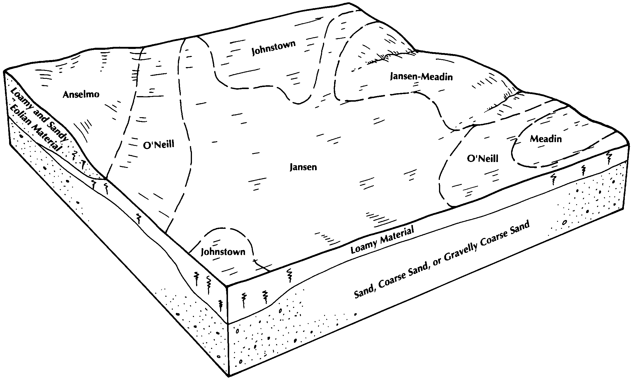
Jansen-Meadin complex, 0 to 2 percent slopes31893174999993c1sne01719871:20000
Oneill-Meadin sandy loams, 6 to 11 percent slopes327525231000183c2dne01719871:20000
Meadin sandy loam, 0 to 2 percent slopes325210721000133c27ne01719871:20000
Meadin loamy sand, 0 to 2 percent slopes32499431004153ch6ne03119951:24000
Meadin loamy sand, 2 to 30 percent slopes32513031004163ch7ne03119951:24000
Meadin sandy loam, 2 to 30 percent slopes325560616921321tssxne03519791:20000
Nuckolls and Meadin soils, 11 to 30 percent slopes2573668616919812wsdsne06119741:20000
Oneill-Meadin fine sandy loams, 6 to 11 percent slopes3273265731001413c6cne08919811:20000
Oneill-Meadin fine sandy loams, 2 to 6 percent slopes3271248821001403c6bne08919811:20000
Oneill-Meadin fine sandy loams, 11 to 30 percent slopes3270160581001423c6dne08919811:20000
Meadin sandy loam, 0 to 2 percent slopes3252142811001303c60ne08919811:20000
Jansen-Meadin loams, 2 to 6 percent slopes3193111481001113c5dne08919811:20000
Meadin sandy loam, 2 to 30 percent slopes325586141001313c61ne08919811:20000
Meadin loam, 0 to 2 percent slopes324560341001323c62ne08919811:20000
Boelus-Meadin complex, 6 to 11 percent slopes66486551000853c4kne08919811:20000
Meadin-Oneill complex, 2 to 30 percent slopes325942022203042djdqne08919811:20000
Meadin loam, 6 to 30 percent slopes3247186316918281tsh3ne09519701:20000
Jansen-Meadin loams, 0 to 2 percent slopes319212001357702d06sne10319771:20000
Meadin gravelly sandy loam, 2 to 30 percent slopes32449716357712d073ne10319771:20000
Oneill-Meadin fine sandy loams, 0 to 2 percent slopes32696883357718d079ne10319771:20000
Meadin-Oneill complex, 2 to 30 percent slopes32599377114426217dppne10719891:20000
Meadin sandy loam, 0 to 2 percent slopes3252101114426117dpnne10719891:20000
Meadin sandy loam, 2 to 11 percent slopes32538217096691vd1mne12119781:20000
Meadin loamy fine sand, 0 to 2 percent slopes324895427492gbv2ne12519581:20000
Meadin loam, 6 to 30 percent slopes324779516920881tsrhne12919741:20000
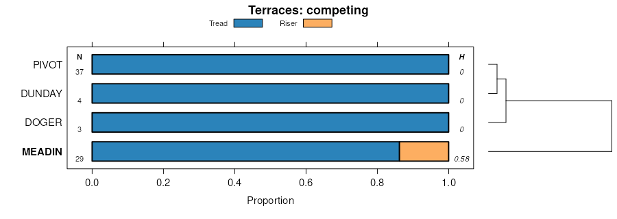
Meadin loamy sand, terrace, 0 to 2 percent slopes3100168716917191tsclne13719671:20000
Meadin silt loam, terrace, 0 to 2 percent slopes31017716917201tscmne13719671:20000
Meadin loamy sand, 0 to 6 percent slopes325079116923061tszjne14319671:20000
Simeon-Meadin complex, 0 to 9 percent slopes893632861002553cb1ne14919821:20000
Oneill-Meadin sandy loams, 6 to 11 percent slopes327511231002503c9wne14919821:20000
Meadin sandy loam, 0 to 2 percent slopes32529611002473c9sne14919821:20000
Oneill-Meadin sandy loams, 2 to 6 percent slopes32746722198382dhxpne14919821:20000
Meadin soils, 7 to 30 percent slopes, eroded325677516912301trvtne15919671:20000
Jansen-Meadin complex, 11 to 30 percent slopes, eroded3191928216924271tt3fne16919651:20000
Jansen-Meadin complex, 6 to 11 percent slopes, eroded3190836216924251tt3cne16919651:20000
Meadin loam, 2 to 30 percent slopes3246418916924381tt3sne16919651:20000
Muir-Meadin complex, 0 to 3 percent slopes3779158616924342tpy1ne16919651:20000
Meadin loam, 6 to 30 percent slopes32472522187272dgrvne16919651:20000
Meadin loamy sand, 2 to 30 percent slopes325113626056782qjl1ne17119631:24000
Meadin loamy sand, 0 to 2 percent slopes32496526056772qjl0ne17119631:24000
Meadin loam, 6 to 30 percent slopes3247896816920351tspsne18119671:20000
Meadin loam, 15 to 30 percent slopesMeE328355052cxg9sd02319801:20000
Meadin sandy loam, 3 to 9 percent slopesMeC12424355261cxp1sd05319821:20000
Meadin sandy loam, 9 to 25 percent slopesMeE11183355262cxp2sd05319821:20000

Map of Series Extent

Approximate geographic distribution of the MEADIN soil series. To learn more about how this distribution was mapped, or to compare this soil series extent to others, use the Series Extent Explorer (SEE) application. Source: generalization of SSURGO geometry .