| McCook loam, 0 to 1 percent slopes | McA | 1874 | 94202 | 350s | co009 | 1966 | 1:20000 |
McCook loam, 1 to 3 percent slopes | McB | 43 | 94203 | 350t | co009 | 1966 | 1:20000 |
McCook loam | Mc | 329 | 94953 | 35t0 | co115 | 1969 | 1:15840 |
McCook silt loam, rarely flooded | 2347 | 1536 | 1382013 | 2twl9 | ks029 | 1972 | 1:24000 |
McCook silt loam, occasionally flooded | 2177 | 16870 | 1150579 | 2wsf6 | ks039 | 1985 | 1:24000 |
McCook silt loam, occasionally flooded | 2177 | 9848 | 1454524 | 2wsfd | ks041 | 1977 | 1:24000 |
McCook-Smokyhill silt loams, occasionally flooded | 2181 | 418 | 1454525 | 2xlgs | ks041 | 1977 | 1:24000 |
McCook silt loam, rarely flooded | 2347 | 6555 | 1150149 | 2twl9 | ks051 | 1970 | 1:24000 |
McCook fine sandy loam, rarely flooded | 2345 | 1015 | 1150148 | 2xlgt | ks051 | 1970 | 1:24000 |
McCook silt loam, rarely flooded | 2347 | 5645 | 1382223 | 2twl9 | ks053 | 1985 | 1:24000 |
McCook silty clay loam, frequently flooded | 2178 | 1066 | 1382224 | 2xlgq | ks053 | 1985 | 1:24000 |
McCook loam, occasionally flooded | 2176 | 1050 | 1382222 | 2wsfc | ks053 | 1985 | 1:24000 |
McCook-Smokyhill silt loams, occasionally flooded | 2181 | 3473 | 1387160 | 2xlgs | ks061 | 1991 | 1:24000 |
McCook silt loam, rarely flooded | 2347 | 1140 | 1387161 | 2xlgv | ks061 | 1991 | 1:24000 |
McCook silt loam, occasionally flooded | 2177 | 1127 | 1387159 | 2wsfd | ks061 | 1991 | 1:24000 |
McCook silt loam, rarely flooded | 2347 | 46 | 1150808 | 2twl9 | ks065 | 1985 | 1:24000 |
McCook silt loam, rarely flooded | 2347 | 2187 | 1381866 | 2twl9 | ks089 | 1981 | 1:24000 |
McCook fine sandy loam, rarely flooded | 2345 | 11 | 2605754 | 2xlgt | ks089 | 1981 | 1:24000 |
McCook silt loam, rarely flooded | 2347 | 5134 | 1382095 | 2twl9 | ks105 | 1983 | 1:24000 |
McCook fine sandy loam, rarely flooded | 2345 | 2229 | 1429196 | 2xlgt | ks113 | 1980 | 1:24000 |
McCook silt loam, rarely flooded | 2347 | 62 | 1429197 | 2twl9 | ks113 | 1980 | 1:24000 |
McCook loam, occasionally flooded | 2176 | 24 | 1429193 | 2wsfc | ks113 | 1980 | 1:24000 |
McCook silt loam, rarely flooded | 2347 | 5924 | 1381986 | 2twl9 | ks123 | 1977 | 1:24000 |
McCook silt loam, occasionally flooded | 2177 | 3119 | 1381985 | 2wsf6 | ks123 | 1977 | 1:24000 |
McCook silt loam, occasionally flooded | 2177 | 1911 | 1150765 | 2wsf6 | ks137 | 1973 | 1:24000 |
McCook silt loam, rarely flooded | 2347 | 7954 | 1151020 | 2twl9 | ks141 | 1971 | 1:24000 |
Munjor-McCook complex, occasionally flooded | 2205 | 6732 | 1151022 | 2wsfn | ks141 | 1971 | 1:24000 |
McCook-Munjor complex, occasionally flooded | 2180 | 166 | 1151021 | 2wsfh | ks141 | 1971 | 1:24000 |
McCook silt loam, occasionally flooded | 2177 | 154 | 1151019 | 2wsf6 | ks141 | 1971 | 1:24000 |
McCook silt loam, rarely flooded | 2347 | 6564 | 1382137 | 2twl9 | ks143 | 1978 | 1:24000 |
McCook soils, occasionally flooded | 2179 | 2460 | 1382138 | 2xlgr | ks143 | 1978 | 1:24000 |
McCook silt loam, rarely flooded | 2347 | 10247 | 1150915 | 2twl9 | ks147 | 1985 | 1:24000 |
McCook silt loam, rarely flooded | 2347 | 7077 | 1150259 | 2twl9 | ks163 | 1980 | 1:24000 |
Munjor-McCook complex, occasionally flooded | 2205 | 24 | 1150261 | 2wsfn | ks163 | 1980 | 1:24000 |
McCook silt loam, rarely flooded | 2347 | 47 | 1152129 | 2twl9 | ks165 | 1978 | 1:24000 |
McCook silt loam, rarely flooded | 2347 | 8653 | 1150971 | 2twl9 | ks167 | 1980 | 1:24000 |
McCook silt loam, rarely flooded | 2347 | 13810 | 1382182 | 2twl9 | ks169 | 1989 | 1:24000 |
McCook silt loam, occasionally flooded | 2177 | 3604 | 1382181 | 2wsfd | ks169 | 1989 | 1:24000 |
McCook soils, occasionally flooded | 2179 | 12 | 1382183 | 2xlgr | ks169 | 1989 | 1:24000 |
McCook silt loam, occasionally flooded | 2177 | 798 | 1150002 | 2wsf6 | ks179 | 1982 | 1:24000 |
McCook silt loam, rarely flooded | 2347 | 10185 | 1151124 | 2twl9 | ks183 | 1974 | 1:24000 |
McCook-Munjor complex, occasionally flooded | 2180 | 3378 | 1151125 | 2wsfh | ks183 | 1974 | 1:24000 |
McCook silt loam, occasionally flooded | 2177 | 2716 | 1150864 | 2wsf6 | ks195 | 1986 | 1:24000 |
McCook silt loam, rarely flooded | 2347 | 78 | 1150865 | 2twl9 | ks195 | 1986 | 1:24000 |
McCook loam, occasionally flooded | 2176 | 1180 | 357812 | d0bb | ne013 | 1980 | 1:20000 |
McCook silt loam, rarely flooded | 2347 | 1230 | 1699048 | 31rh9 | ne029 | 1980 | 1:20000 |
McCook silt loam, occasionally flooded | 2177 | 862 | 1699049 | 1v101 | ne029 | 1980 | 1:20000 |
McCook silt loam, channeled, occasionally flooded | 2109 | 159 | 1699050 | 31rh8 | ne029 | 1980 | 1:20000 |
McCook very fine sandy loam, 0 to 1 percent slopes | 2306 | 2243 | 1698698 | 1v0mq | ne033 | 1989 | 1:20000 |
McCook silt loam, rarely flooded | 2347 | 2140 | 1691974 | 2twl9 | ne061 | 1974 | 1:20000 |
McCook fine sandy loam, rarely flooded | 2345 | 948 | 1691973 | 2xlgt | ne061 | 1974 | 1:20000 |
McCook silt loam, occasionally flooded | 2177 | 5002 | 1699417 | 1v1cx | ne063 | 1973 | 1:20000 |
McCook silt loam, rarely flooded | 2347 | 1628 | 1699415 | 2twl9 | ne063 | 1973 | 1:20000 |
McCook silt loam, wet, occasionally flooded | 2114 | 871 | 1699418 | 2zwll | ne063 | 1973 | 1:20000 |
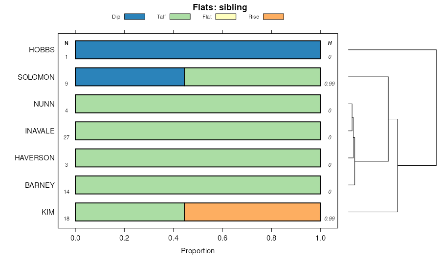
Hobbs-McCook silt loams, occasionally flooded | 3563 | 12793 | 1699746 | 2yl4d | ne065 | 1975 | 1:20000 |
McCook silt loam, rarely flooded | 2347 | 6746 | 1699760 | 2twl9 | ne065 | 1975 | 1:20000 |
Hobbs and McCook silt loams, occasionally flooded | 3541 | 5904 | 1692241 | 2zwjk | ne083 | 1967 | 1:20000 |
McCook loam, occasionally flooded | 2176 | 3732 | 1692255 | 2wsf7 | ne083 | 1967 | 1:20000 |
McCook sand, occasionally flooded | 2117 | 1208 | 1692254 | 2yl4j | ne083 | 1967 | 1:20000 |
Platte and McCook soils | 8561 | 674 | 1692261 | 2zwlm | ne083 | 1967 | 1:20000 |
McCook silt loam, rarely flooded | 2347 | 127 | 2219514 | 2twl9 | ne083 | 1967 | 1:20000 |
Hobbs-McCook silt loams, occasionally flooded | 3563 | 114 | 2219522 | 2yl4d | ne083 | 1967 | 1:20000 |
McCook silt loam, occasionally flooded | 2177 | 4692 | 1699257 | 1v16r | ne085 | 1981 | 1:20000 |
McCook silt loam, channeled, occasionally flooded | 2109 | 1073 | 1699258 | 31rh8 | ne085 | 1981 | 1:20000 |
McCook silt loam, rarely flooded | 2347 | 443 | 1699256 | 31rh9 | ne085 | 1981 | 1:20000 |
McCook loam, rarely flooded | 2302 | 3278 | 1699308 | 31rhc | ne087 | 1965 | 1:20000 |
McCook loam, frequently flooded | 2000 | 2822 | 1699275 | 31rhb | ne087 | 1965 | 1:20000 |
McCook silt loam, channeled, occasionally flooded | 2109 | 842 | 2228856 | 31rh8 | ne087 | 1965 | 1:20000 |
McCook loam, sand substratum variant, occasionally flooded | 2112 | 745 | 1699276 | 31rhf | ne087 | 1965 | 1:20000 |
McCook silt loam, occasionally flooded | 2177 | 106 | 2228851 | 2dt9f | ne087 | 1965 | 1:20000 |
McCook silt loam, rarely flooded | 2347 | 9 | 2228852 | 31rh9 | ne087 | 1965 | 1:20000 |
Hobbs and McCook silt loams, occasionally flooded | 3541 | 6060 | 1699182 | 2yl4c | ne111 | 1971 | 1:24000 |
McCook loam, saline-alkali | 2309 | 4888 | 1699209 | 1v156 | ne111 | 1971 | 1:24000 |
McCook loam, rarely flooded | 2302 | 1512 | 1699208 | 31rhd | ne111 | 1971 | 1:24000 |
McCook silt loam, occasionally flooded | 2177 | 1401 | 2219752 | 2dhtx | ne111 | 1971 | 1:24000 |
McCook very fine sandy loam, 0 to 1 percent slopes | 2306 | 2755 | 1692634 | 1ttb3 | ne123 | 1981 | 1:20000 |
McCook fine sandy loam, rarely flooded | 2345 | 1848 | 1692086 | 2xlgt | ne129 | 1974 | 1:20000 |
McCook silt loam, rarely flooded | 2347 | 1773 | 1692087 | 2twl9 | ne129 | 1974 | 1:20000 |
McCook silt loam, occasionally flooded | 2177 | 3216 | 1698979 | 1v0xs | ne135 | 1987 | 1:20000 |
Hobbs-McCook silt loams, occasionally flooded | 3563 | 6313 | 2219116 | 2yl4d | ne145 | 1965 | 1:20000 |
McCook and Bigbend loams | 2305 | 5923 | 1699463 | 2zwkj | ne145 | 1965 | 1:20000 |
McCook silt loam, occasionally flooded | 2177 | 3137 | 2219096 | 2dh4r | ne145 | 1965 | 1:20000 |
McCook loam, occasionally flooded | 2176 | 2568 | 1699436 | 2wsf7 | ne145 | 1965 | 1:20000 |
McCook silt loam, rarely flooded | 2347 | 946 | 2219097 | 2twl9 | ne145 | 1965 | 1:20000 |
McCook loam, rarely flooded | 2302 | 85 | 2219073 | 31rhc | ne145 | 1965 | 1:20000 |
McCook loam, rarely flooded | 2302 | 8498 | 1653765 | 1shw8 | ne157 | 1965 | 1:20000 |
McCook silty clay loam, gravel substratum variant | 2307 | 238 | 1653704 | 1sht9 | ne157 | 1965 | 1:20000 |
McCook loam, rarely flooded | 2302 | 2567 | 100615 | 3cpn | ne161 | 1992 | 1:20000 |
McCook loam, channeled, frequently flooded | 2001 | 1001 | 100616 | 3cpp | ne161 | 1992 | 1:20000 |
McCook silt loam, rarely flooded | 2347 | 6894 | 1692034 | 2twl9 | ne181 | 1967 | 1:20000 |
McCook fine sandy loam, very rarely flooded | 2304 | 393 | 1692031 | 2zwkk | ne181 | 1967 | 1:20000 |
Haverson and McCook loams, 0 to 3 percent slopes | HnA | 5899 | 104703 | 3hyj | wy615 | 1965 | 1:20000 |