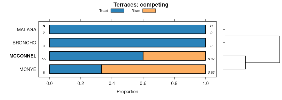
| Cewat-McConnel-Toulon association, 2 to 15 percent slopes | 149 | 7053 | 487402 | jc5n | ca608 | 2000 | 1:24000 |
McConnel-Mottsville complex, 2 to 9 percent slopes | 283 | 2481 | 487594 | jccv | ca608 | 2000 | 1:24000 |
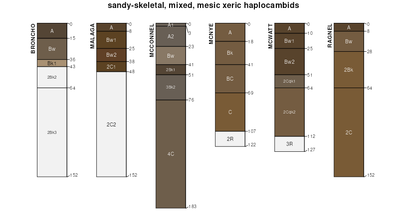
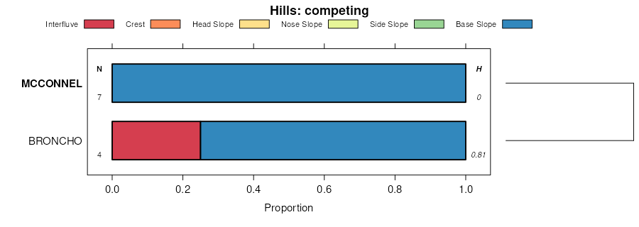
McConnel gravelly fine sandy loam | Mf | 4529 | 476112 | hzfg | nv612 | 1968 | 1:24000 |
McConnel-Blackhawk complex | Mh | 2915 | 476113 | hzfh | nv612 | 1968 | 1:24000 |
McConnel-Ocala complex | Mo | 424 | 476114 | hzfj | nv612 | 1968 | 1:24000 |
McConnel very stony sandy loam, 2 to 8 percent slopes | 1120 | 100 | 474486 | hxr0 | nv759 | 1995 | 1:24000 |
McConnel very stony sandy loam, 2 to 8 percent slopes | 580 | 16381 | 474766 | hy11 | nv760 | 1994 | 1:24000 |
McConnel very gravelly fine sandy loam, 0 to 2 percent slopes 1/ | 581 | 2521 | 474767 | hy12 | nv760 | 1994 | 1:24000 |
McConnel-Rasille-Wholan association | 633 | 35868 | 479287 | j2qw | nv768 | 1985 | 1:63360 |
McConnel-Orovada-Misad association | 632 | 6261 | 479286 | j2qv | nv768 | 1985 | 1:63360 |
McConnel-Wholan association | 638 | 4371 | 479291 | j2r0 | nv768 | 1985 | 1:63360 |
McConnel-Rasille association | 635 | 3754 | 479288 | j2qx | nv768 | 1985 | 1:63360 |
Orovada-McConnel association | 704 | 2965 | 479301 | j2rb | nv768 | 1985 | 1:63360 |
McConnel-Defler-Rasille association | 636 | 2292 | 479289 | j2qy | nv768 | 1985 | 1:63360 |
McConnel-Orovada association | 637 | 1999 | 479290 | j2qz | nv768 | 1985 | 1:63360 |
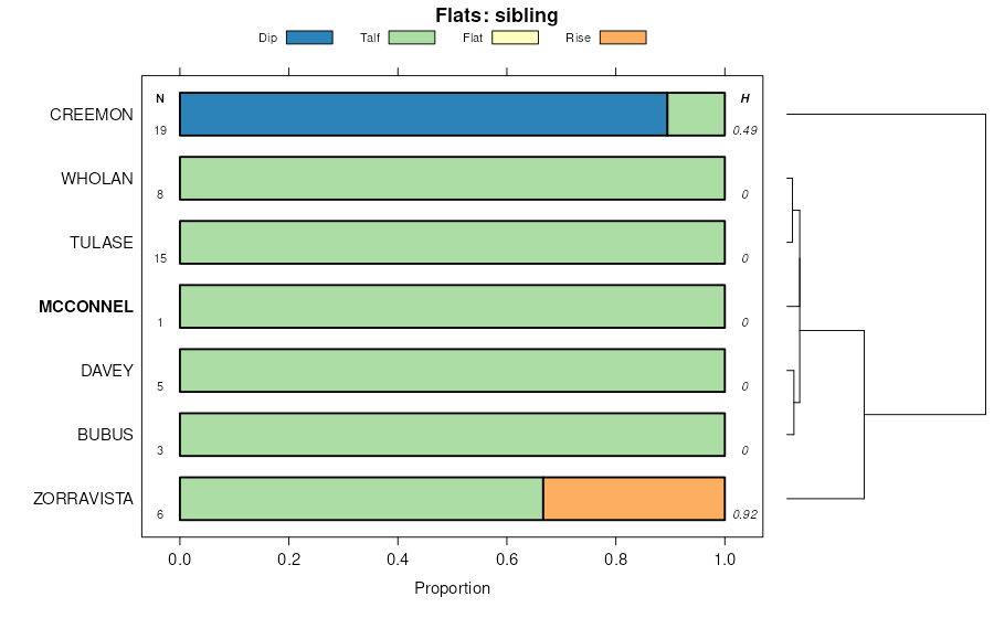
Tulase-Bubus-McConnel association | 1092 | 1717 | 479034 | 2v43m | nv768 | 1985 | 1:63360 |
McConnel loam, 0 to 2 percent slopes | 330 | 2143 | 475265 | hyk4 | nv769 | 1986 | 1:24000 |
McConnel gravelly fine sandy loam, 4 to 8 percent slopes | 331 | 1428 | 475266 | hyk5 | nv769 | 1986 | 1:24000 |
Beoska-Oxcorel-McConnel association | 177 | 5405 | 479504 | j2yw | nv775 | 1985 | 1:24000 |
McConnel-Tulase association | 631 | 4220 | 479696 | j352 | nv775 | 1985 | 1:24000 |
Tulase-Bubus-McConnel association | 1092 | 1785 | 479409 | 2v43m | nv775 | 1985 | 1:24000 |
Tulase-Bubus-McConnel association | 1203 | 12688 | 479769 | 2v43m | nv776 | 1983 | 1:63360 |
Enko-Davey-McConnel association | 822 | 7238 | 479894 | j3cg | nv776 | 1983 | 1:63360 |
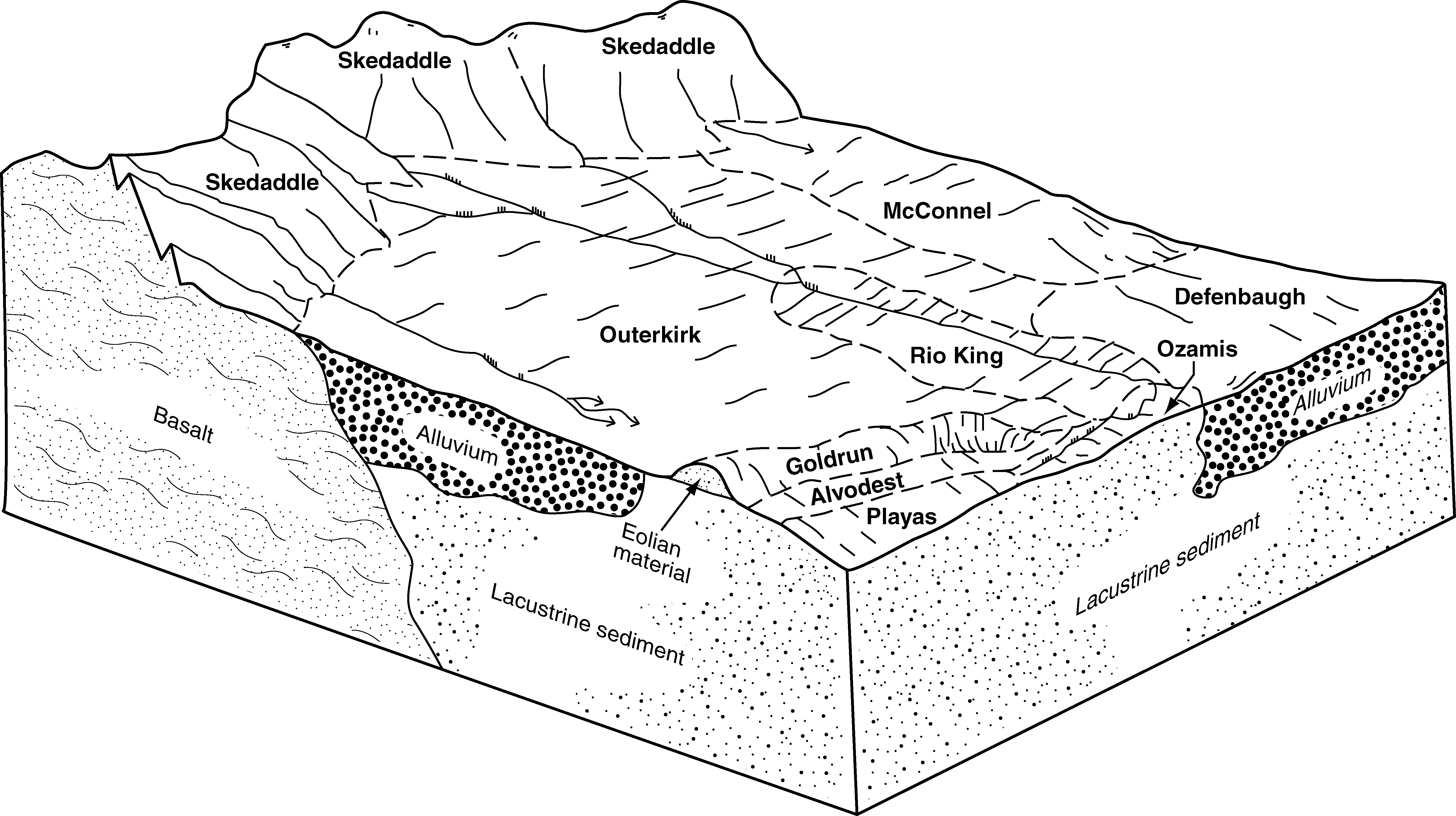
Chiara-Dacker-McConnel association | 185 | 22292 | 475615 | hyxf | nv777 | 1993 | 1:24000 |
Hunnton-Flue-McConnel association | 1172 | 17110 | 475429 | hyqf | nv777 | 1993 | 1:24000 |
Snapp-McConnel-Adelaide association | 756 | 16844 | 475914 | hz72 | nv777 | 1993 | 1:24000 |
McConnel-Pumper-Whirlo complex, 2 to 8 percent slopes | 338 | 15675 | 475691 | hyzw | nv777 | 1993 | 1:24000 |
Connel-McConnel complex, rarely flooded, 0 to 2 percent slopes 1 / | 255 | 13912 | 475652 | hyym | nv777 | 1993 | 1:24000 |
McConnel gravelly fine sandy loam, 2 to 8 percent slopes | 331 | 13722 | 475685 | hyzp | nv777 | 1993 | 1:24000 |
Connel-McConnel complex, 0 to 2 percent slopes 1/ | 253 | 8887 | 475650 | hyyk | nv777 | 1993 | 1:24000 |
McConnel very gravelly fine sandy loam, 0 to 2 percent slopes 1/ | 335 | 5471 | 475689 | hyzt | nv777 | 1993 | 1:24000 |
Zevadez-McConnel association | 963 | 5170 | 476003 | hz9y | nv777 | 1993 | 1:24000 |
McConnel fine sandy loam, 0 to 2 percent slopes 1/ | 330 | 4960 | 475684 | hyzn | nv777 | 1993 | 1:24000 |
McConnel-Shabliss association | 333 | 2846 | 475687 | hyzr | nv777 | 1993 | 1:24000 |
Chiara-McConnel association | 184 | 2349 | 475614 | hyxd | nv777 | 1993 | 1:24000 |
Pyrat-McConnel association | 1494 | 9136 | 480280 | j3rx | nv780 | 1990 | 1:24000 |
Yody-Blimo-McConnel association | 570 | 4763 | 480530 | j40z | nv780 | 1990 | 1:24000 |
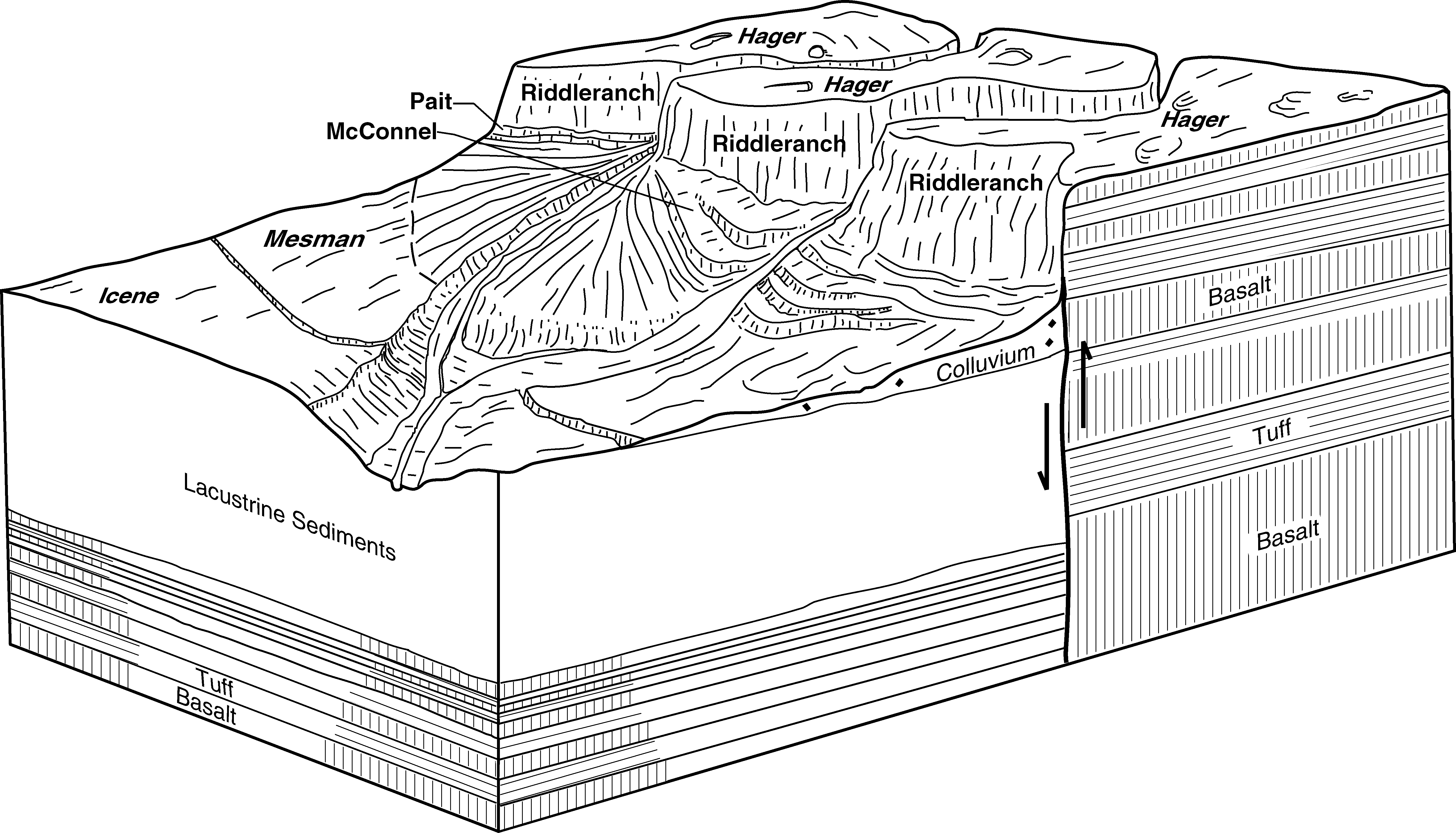
McConnel cobbly sandy loam, 3 to 8 percent slopes | 192 | 25435 | 490570 | jggv | or628 | 1997 | 1:24000 |
Calderwood-McConnel complex, 0 to 20 percent slopes | 53 | 6000 | 490887 | jgt2 | or628 | 1997 | 1:24000 |
Calderwood-McConnel complex, 0 to 20 percent slopes | 238 | 20200 | 1689748 | 1tqb0 | or635 | 2006 | 1:24000 |
Enko-McConnel complex, 0 to 5 percent slopes | 294 | 13696 | 1689803 | 1tqcs | or635 | 2006 | 1:24000 |
McConnel-Poorjug complex, 1 to 15 percent slopes | 439 | 7917 | 1689943 | 1tqj9 | or635 | 2006 | 1:24000 |
McConnel gravelly sandy loam, sodic substratum, 0 to 5 percent slopes | 435 | 4336 | 1689939 | 1tqj5 | or635 | 2006 | 1:24000 |
McConnel very gravelly sandy loam, 0 to 2 percent slopes | 436 | 3550 | 1689940 | 1tqj6 | or635 | 2006 | 1:24000 |
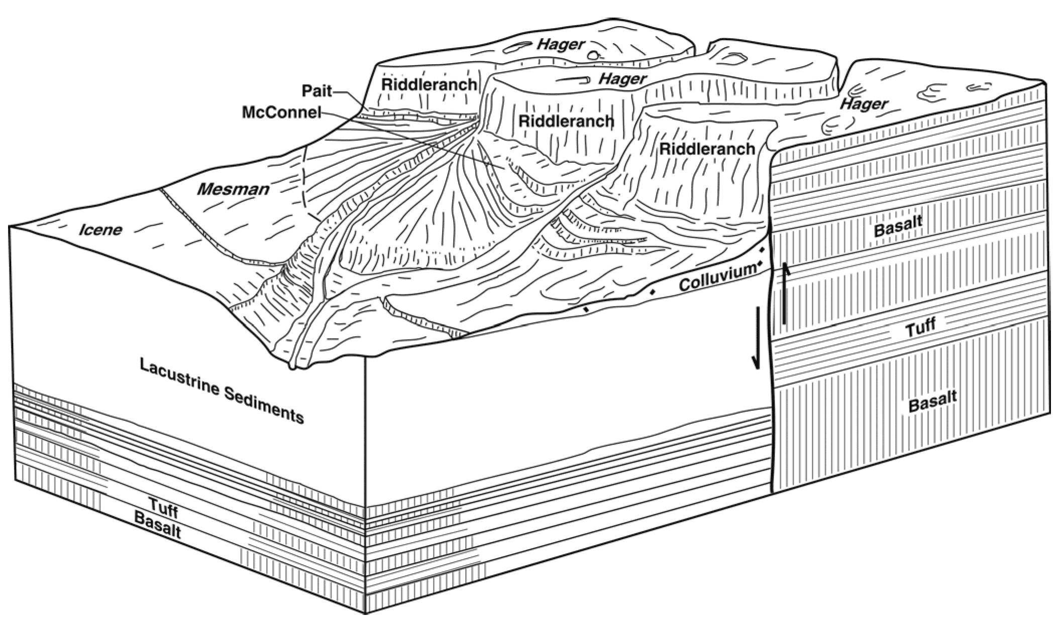
Mesman-McConnel-Kewake complex, 2 to 8 percent slopes | 447 | 2260 | 1689951 | 1tqjk | or635 | 2006 | 1:24000 |
Locolake-McConnel complex, 3 to 10 percent slopes | 419 | 2149 | 1689924 | 1tqhp | or635 | 2006 | 1:24000 |
McConnel very gravelly sandy loam, 2 to 15 percent slopes | 437 | 1875 | 1689941 | 1tqj7 | or635 | 2006 | 1:24000 |
McConnel-Turpin complex, 2 to 15 percent slopes | 440 | 1351 | 1689944 | 1tqjb | or635 | 2006 | 1:24000 |
McConnel-Davey complex, 15 to 45 percent slopes | 438 | 1060 | 1689942 | 1tqj8 | or635 | 2006 | 1:24000 |
McConnel cobbly sandy loam, 3 to 8 percent slopes | 434 | 486 | 1689938 | 1tqj4 | or635 | 2006 | 1:24000 |
McConnel very gravelly sandy loam, 2 to 15 percent slopes | 153C | 11210 | 488968 | jdt5 | or636 | 1991 | 1:24000 |
McConnel very gravelly sandy loam, 0 to 2 percent slopes | 153A | 6140 | 488967 | jdt4 | or636 | 1991 | 1:24000 |
McConnel gravelly sandy loam, sodic substratum, 0 to 5 percent slopes | 156B | 1312 | 488972 | jdt9 | or636 | 1991 | 1:24000 |
McConnel-Icene complex, 0 to 15 percent slopes | 157C | 1121 | 488973 | jdtb | or636 | 1991 | 1:24000 |
McConnel very gravelly sandy loam, cold, 2 to 15 percent slopes | 155C | 614 | 488971 | jdt8 | or636 | 1991 | 1:24000 |
McConnel extremely stony loam, 5 to 15 percent slopes | 154C | 519 | 488969 | jdt6 | or636 | 1991 | 1:24000 |
McConnel association, 30 to 50 percent slopes | 158F | 448 | 488974 | jdtc | or636 | 1991 | 1:24000 |
McConnel cobbly sandy loam, 3 to 8 percent slopes | 450B | 93 | 1720982 | 1vrtk | or636 | 1991 | 1:24000 |
McConnel cobbly sandy loam, 3 to 8 percent slopes | OR0192 | 906 | 2494086 | 2pr0n | or644 | 2021 | 1:24000 |