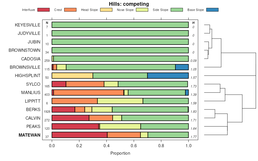
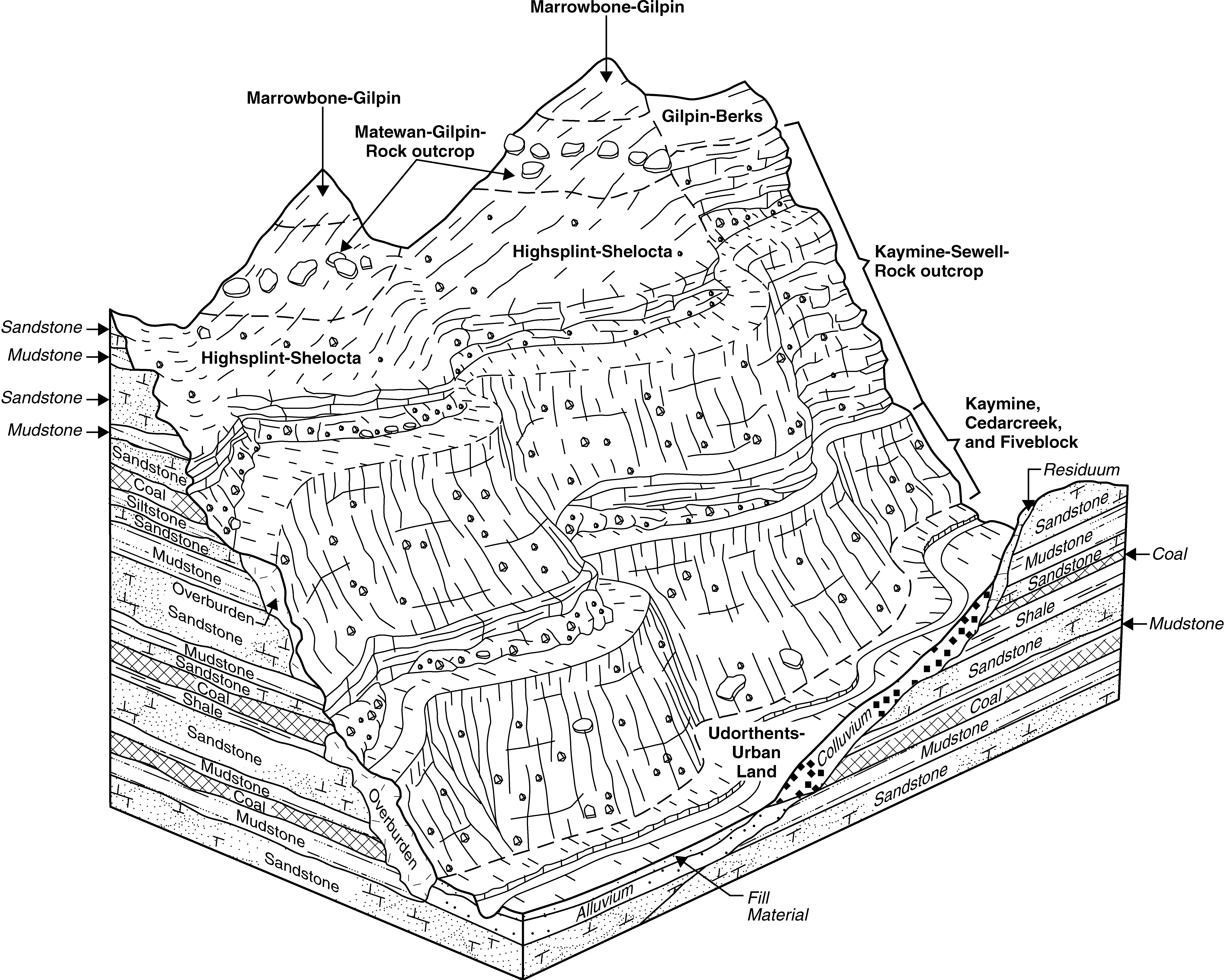
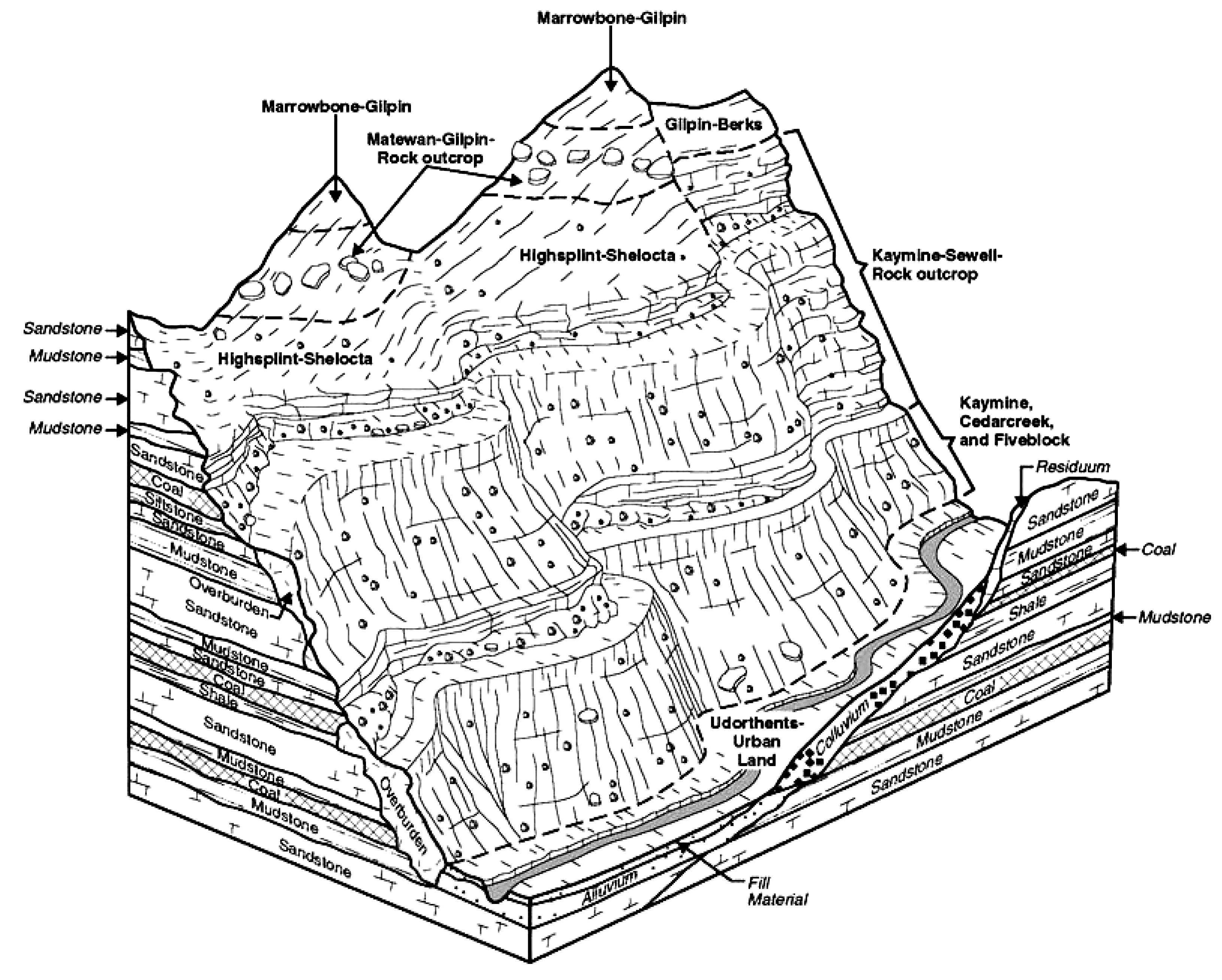
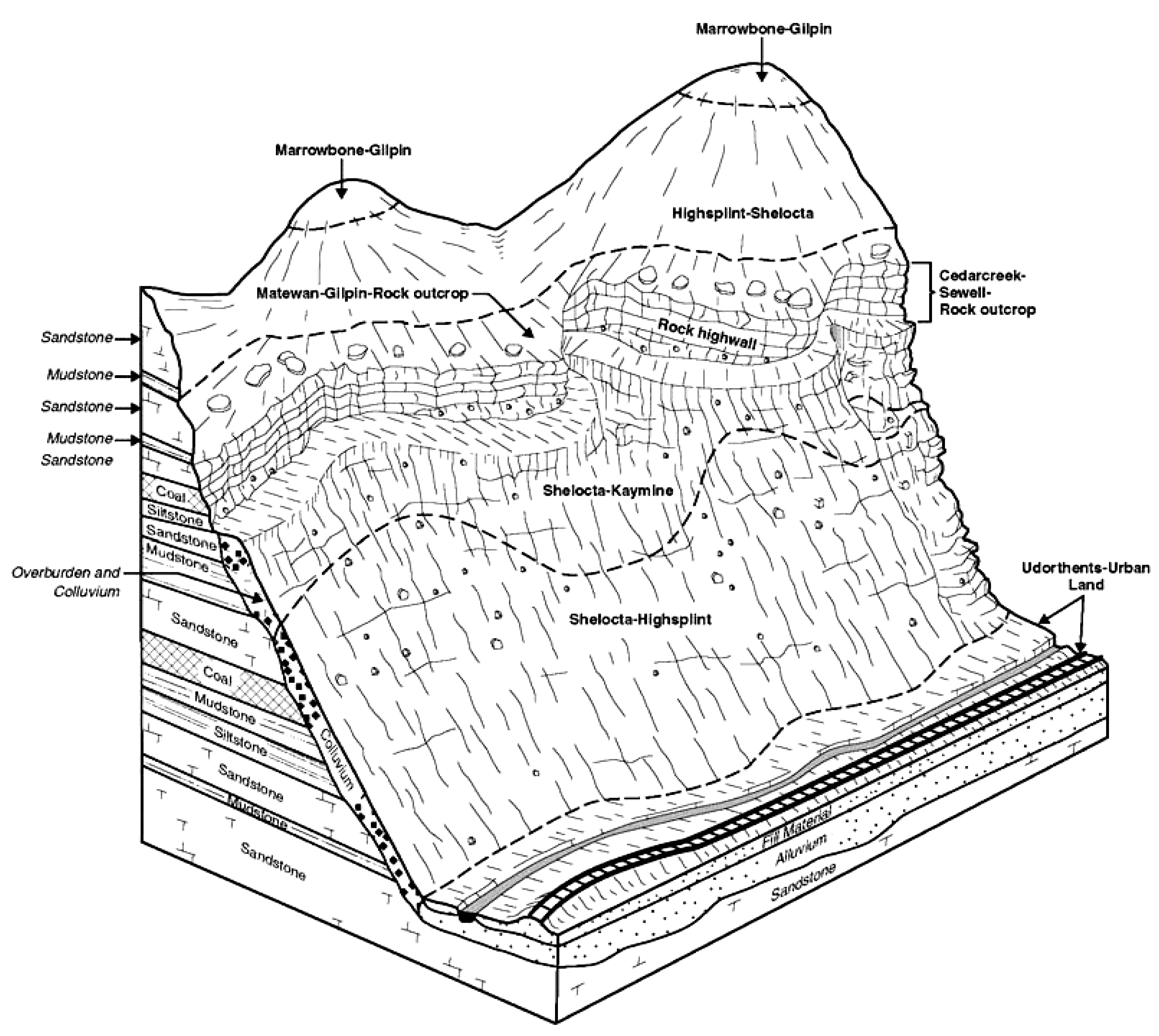
| Matewan-Marrowbone-Latham complex, 20 to 80 percent slopes, very rocky | DmE | 48061 | 550340 | 2tqh8 | ky025 | 1991 | 1:24000 |
Matewan-Gilpin-Marrowbone complex, 12 to 80 percent slopes, very rocky | uMgmF | 31097 | 3158447 | 2yksr | ky025 | 1991 | 1:24000 |
Marrowbone-Blairton-Matewan complex, 25 to 60 percent slopes, rocky | MaF | 2589 | 1884682 | 21856 | ky063 | 2007 | 1:12000 |
Marrowbone-Clifftop-Matewan complex, 35 to 75 percent slopes, very rocky | MaF | 151505 | 550039 | 2tqhc | ky195 | 1986 | 1:24000 |
Matewan-Gilpin-Marrowbone complex, 12 to 80 percent slopes, very rocky | uMgmF | 38837 | 550728 | 2yksr | ky626 | 1997 | 1:24000 |
Matewan-Marrowbone-Latham complex, 20 to 80 percent slopes, very rocky | DLF | 126233 | 552142 | 2tqh8 | ky633 | 1979 | 1:24000 |
Matewan-Gilpin-Marrowbone complex, 12 to 80 percent slopes, very rocky | uMgmF | 84587 | 550860 | 2yksr | ky639 | 1991 | 1:24000 |
Matewan-Gilpin-Marrowbone complex, 12 to 80 percent slopes, very rocky | uMgmF | 21467 | 550931 | 2yksr | ky641 | 1994 | 1:24000 |
Matewan channery loam, 8 to 15 percent slopes | MeC | 99 | 2421655 | 2xb2h | pa005 | 2012 | 1:24000 |
Matewan channery loam, 15 to 25 percent slopes | MeD | 77 | 2421656 | 2xb2j | pa005 | 2012 | 1:24000 |
Matewan channery loam, 3 to 8 percent slopes | MeB | 68 | 2421654 | 2xb2g | pa005 | 2012 | 1:24000 |
Matewan channery loam, 3 to 8 percent slopes | MeB | 1311 | 1591080 | 2xb2g | pa051 | 2005 | 1:24000 |
Matewan channery loam, 8 to 15 percent slopes | MeC | 1052 | 1591081 | 2xb2h | pa051 | 2005 | 1:24000 |
Matewan channery loam, 25 to 50 percent slopes | MeF | 789 | 1591083 | 2xb2k | pa051 | 2005 | 1:24000 |
Matewan channery loam, 15 to 25 percent slopes | MeD | 518 | 1591082 | 2xb2j | pa051 | 2005 | 1:24000 |
Matewan channery loam, 3 to 8 percent slopes | MeB | 257 | 2393815 | 2xb2g | pa063 | 2012 | 1:24000 |
Matewan channery loam, 15 to 25 percent slopes | MeD | 234 | 2393817 | 2xb2j | pa063 | 2012 | 1:24000 |
Matewan channery loam, 8 to 15 percent slopes | MeC | 173 | 2393816 | 2xb2h | pa063 | 2012 | 1:24000 |
Matewan channery loam, 25 to 50 percent slopes | MeF | 156 | 2393818 | 2xb2k | pa063 | 2012 | 1:24000 |
Matewan channery loam, 3 to 8 percent slopes | MeB | 3415 | 544623 | 2xb2g | pa129 | 2003 | 1:24000 |
Matewan channery loam, 8 to 15 percent slopes | MeC | 1531 | 544624 | 2xb2h | pa129 | 2003 | 1:24000 |
Matewan channery loam, 15 to 25 percent slopes | MeD | 1404 | 544625 | 2xb2j | pa129 | 2003 | 1:24000 |
Matewan channery loam, 25 to 50 percent slopes | MeF | 176 | 544684 | 2xb2k | pa129 | 2003 | 1:24000 |
Matewan channery loam, 3 to 8 percent slopes | DaB | 1062 | 542144 | 2xb2g | pa611 | 1979 | 1:15840 |
Matewan channery loam, 15 to 25 percent slopes | DaD | 817 | 542146 | 2xb2j | pa611 | 1979 | 1:15840 |
Matewan channery loam, 8 to 15 percent slopes | DaC | 614 | 542145 | 2xb2h | pa611 | 1979 | 1:15840 |
Matewan-Clifftop-Rock outcrop complex, 35 to 80 percent slopes, extremely stony | 18F | 47891 | 1670829 | 2x5jk | va027 | 2006 | 1:24000 |
Matewan-Clifftop-Rock outcrop complex, 35 to 80 percent slopes, extremely stony | 19F | 30709 | 2399879 | 2x5jk | va051 | 2008 | 1:24000 |
Matewan-Rock outcrop complex, 55 to 80 percent slopes, extremely stony | 40F | 486 | 1671844 | 1t3pg | va167 | 2006 | 1:24000 |
Matewan-Clifftop-Rock outcrop complex, 35 to 80 percent slopes, extremely stony | 50G | 921 | 2508580 | 2x5jk | va195 | 2010 | 1:24000 |
Matewan-Pineville-Guyandotte association, very steep, extremely stony | DPF | 213100 | 514855 | 2tqhx | wv005 | 1988 | 1:24000 |
Kaymine-Cedarcreek-Matewan complex, 35 to 65 percent slopes, extremely stony | KmF | 19705 | 514863 | 2tqhh | wv005 | 1988 | 1:24000 |
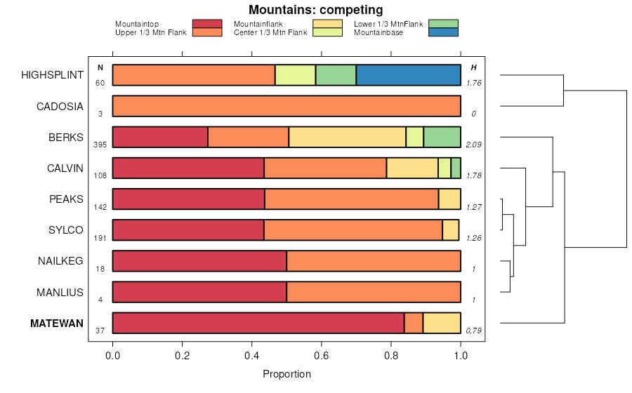
Highsplint-Matewan-Cloverlick association, very steep, extremely stony | HMF | 77330 | 557358 | 2tqhw | wv043 | 2005 | 1:24000 |
Rayne-Matewan complex, 35 to 65 percent slopes, very stony | RmF | 66376 | 557377 | lpzx | wv043 | 2005 | 1:24000 |
Gilpin-Matewan complex, 25 to 35 percent slopes, very stony | GmE | 5836 | 553347 | lksx | wv043 | 2005 | 1:24000 |
Matewan-Pineville-Guyandotte association, very steep, extremely stony | MPF | 949 | 1401518 | 2tqhx | wv043 | 2005 | 1:24000 |
Matewan-Latham complex, 25 to 35 percent slopes, very stony | MlE | 551 | 553345 | lksv | wv043 | 2005 | 1:24000 |
Kaymine-Cedarcreek-Matewan complex, 35 to 65 percent slopes, extremely stony | KmF | 134 | 553373 | 2tqhh | wv043 | 2005 | 1:24000 |
Kaymine-Cedarcreek-Matewan complex, 35 to 65 percent slopes, extremely stony | KcF | 15960 | 532217 | 2tqhh | wv047 | 1993 | 1:24000 |
Matewan-Pineville-Guyandotte association, very steep, extremely stony | DPG | 43015 | 515007 | 2tqhx | wv099 | 1993 | 1:24000 |
Matewan-Pineville-Guyandotte association, very steep, extremely stony | DPF | 58800 | 513493 | 2tqhx | wv109 | 1984 | 1:24000 |
Kaymine-Cedarcreek-Matewan complex, 35 to 65 percent slopes, extremely stony | KcF | 7760 | 513500 | 2tqhh | wv109 | 1984 | 1:24000 |
Matewan-Highsplint-Guyandotte association, very steep, extremely stony | MHF | 391370 | 1155553 | 2tqj0 | wv620 | 2005 | 1:24000 |
Matewan-Pineville-Guyandotte association, very steep, extremely stony | MPF | 61340 | 1155555 | 2tqhx | wv620 | 2005 | 1:24000 |
Highsplint-Matewan-Cloverlick association, very steep, extremely stony | HMF | 8185 | 1155545 | 2tqhw | wv620 | 2005 | 1:24000 |
Lily-Matewan complex, 15 to 35 percent slopes, very stony | LmE | 2375 | 1155552 | 17sfw | wv620 | 2005 | 1:24000 |
Kaymine-Cedarcreek-Matewan complex, 35 to 65 percent slopes, extremely stony | KcF | 290 | 1155550 | 2tqhh | wv620 | 2005 | 1:24000 |
Matewan-Latham complex, 25 to 35 percent slopes | MnE | 30 | 1155554 | 17sfy | wv620 | 2005 | 1:24000 |
Gilpin-Matewan complex, 25 to 35 percent slopes, very stony | GmE | 30 | 1155542 | 17sfk | wv620 | 2005 | 1:24000 |
Nallen-Matewan complex, 15 to 35 percent slopes | NmE | 134 | 2454340 | 2ncy8 | wv705 | 2009 | 1:24000 |
