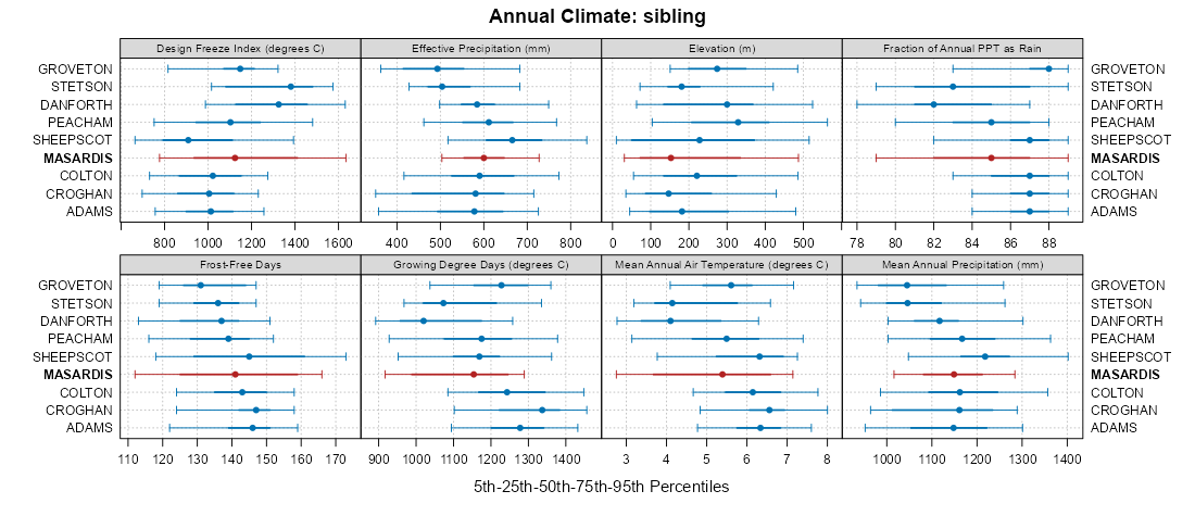
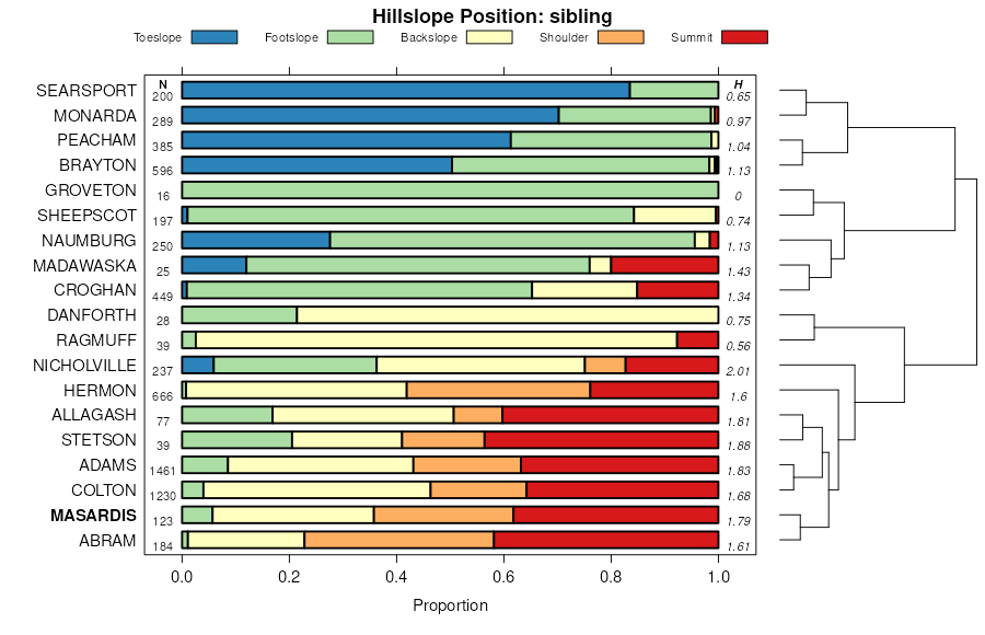
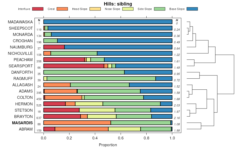
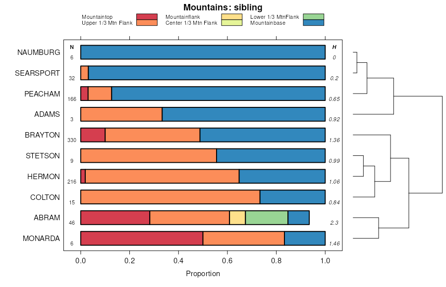
| Masardis fine sandy loam, 8 to 15 percent slopes | MkC | 3412 | 284562 | 3176g | me027 | 1979 | 1:20000 |
Masardis fine sandy loam, 0 to 8 percent slopes | MkB | 3173 | 284561 | 30zw1 | me027 | 1979 | 1:20000 |
Masardis fine sandy loam, 15 to 60 percent slopes | MkE | 1706 | 284563 | 3179p | me027 | 1979 | 1:20000 |
Masardis variant fine sandy loam, very rocky, 3 to 8 percent slopes | MrB | 512 | 284564 | 9k3h | me027 | 1979 | 1:20000 |
Masardis-Rock outcrop complex, moderately deep, 8 to 15 percent slopes | MsC | 410 | 284567 | 2x1dg | me027 | 1979 | 1:20000 |
Masardis variant fine sandy loam, very rocky, 8 to 15 percent slopes | MrC | 382 | 284565 | 9k3j | me027 | 1979 | 1:20000 |
Masardis-Rock outcrop complex, moderately deep, 3 to 8 percent slopes | MsB | 81 | 284566 | 2x1df | me027 | 1979 | 1:20000 |
Masardis fine sandy loam, 3 to 8 percent slopes | MxB | 2043 | 284721 | 3179t | me601 | 1983 | 1:20000 |
Masardis fine sandy loam, 8 to 15 percent slopes | MxC | 1497 | 284722 | 3176g | me601 | 1983 | 1:20000 |
Masardis fine sandy loam, 15 to 25 percent slopes | MxD | 297 | 284723 | 316zz | me601 | 1983 | 1:20000 |
Masardis fine sandy loam, 8 to 15 percent slopes | MkC | 27 | 1153254 | 3176g | me602 | 1967 | 1:20000 |
Masardis-Sheepscot complex, 0 to 15 percent slopes | MLC | 3867 | 285023 | 2x1dc | me610 | 1992 | 1:20000 |
Masardis fine sandy loam, 0 to 8 percent slopes | MhB | 2151 | 285036 | 9klq | me610 | 1992 | 1:20000 |
Masardis-Adams complex, 15 to 70 percent slopes | MKE | 955 | 285022 | 2wqnm | me610 | 1992 | 1:20000 |
Masardis fine sandy loam, 8 to 15 percent slopes | MhC | 368 | 285037 | 3176g | me610 | 1992 | 1:20000 |
Masardis fine sandy loam, 15 to 60 percent slopes | MhD | 280 | 285038 | 3179p | me610 | 1992 | 1:20000 |
Masardis-Adams complex, 3 to 15 percent slopes | MSC | 4306 | 1483104 | 1ls92 | me612 | 2016 | 1:24000 |
Masardis and Adams soils, 8 to 15 percent slopes | MaC | 1414 | 740877 | svy8 | me612 | 2016 | 1:24000 |
Masardis fine sandy loam, 3 to 8 percent slopes | MaB | 1155 | 740876 | svy7 | me612 | 2016 | 1:24000 |
Masardis and Adams soils, 15 to 60 percent slopes | MaE | 503 | 2643634 | 2rk0d | me612 | 2016 | 1:24000 |
Masardis and Adams soils, 15 to 60 percent slopes | MSE | 481 | 746063 | t1bk | me612 | 2016 | 1:24000 |
Danforth-Masardis-Peacham association, 0 to 15 percent slopes, extremely stony | DEC | 25906 | 285321 | 2x1dp | me615 | 1994 | 1:24000 |
Masardis fine sandy loam, 0 to 15 percent slopes | MSC | 2735 | 285341 | 30zw2 | me615 | 1994 | 1:24000 |
Masardis-Adams complex, 15 to 70 percent slopes | MTE | 1226 | 285342 | 2wqnm | me615 | 1994 | 1:24000 |
Masardis fine sandy loam, 0 to 8 percent slopes | MrB | 641 | 285348 | 30zw1 | me615 | 1994 | 1:24000 |
Masardis fine sandy loam, 0 to 3 percent slopes | MmA | 6151 | 285602 | 30zw0 | me617 | 2004 | 1:24000 |
Masardis-Sheepscot complex, 0 to 15 percent slopes | MSC | 5424 | 285596 | 2x1dc | me617 | 2004 | 1:24000 |
Masardis fine sandy loam, 3 to 8 percent slopes | MmB | 2198 | 285603 | 3179t | me617 | 2004 | 1:24000 |
Masardis fine sandy loam, 8 to 15 percent slopes | MmC | 1456 | 285604 | 3176g | me617 | 2004 | 1:24000 |
Masardis-Adams complex, 15 to 70 percent slopes | MRE | 1375 | 285595 | 2wqnm | me617 | 2004 | 1:24000 |
Masardis fine sandy loam, 15 to 60 percent slopes | MmE | 1328 | 285605 | 3179p | me617 | 2004 | 1:24000 |
Masardis-Danforth-Peacham association, 0 to 15 percent slopes, extremely stony | MMC | 31965 | 285662 | 2x1dh | me619 | 2005 | 1:24000 |
Masardis-Adams complex, 3 to 15 percent slopes | MKC | 22612 | 285654 | 2x1cc | me619 | 2005 | 1:24000 |
Masardis-Adams complex, 15 to 70 percent slopes | MKD | 2323 | 285655 | 2wqnm | me619 | 2005 | 1:24000 |
Danforth-Masardis-Peacham association, 0 to 15 percent slopes, extremely stony | DMB | 25343 | 2549896 | 2x1dp | me620 | 2011 | 1:24000 |
Masardis-Adams complex, 3 to 15 percent slopes | MAC | 6530 | 2549895 | 2x1cc | me620 | 2011 | 1:24000 |
Danforth and Masardis soils, 3 to 15 percent slopes, extremely stony | DMC | 3190 | 2549897 | 2qtll | me620 | 2011 | 1:24000 |
Masardis-Sheepscot complex, 0 to 8 percent slopes | MSB | 2086 | 2549893 | 2x1dd | me620 | 2011 | 1:24000 |
Masardis-Adams complex, 15 to 70 percent slopes | AME | 836 | 2549883 | 2wqnm | me620 | 2011 | 1:24000 |
Danforth-Masardis-Peacham association, 0 to 15 percent slopes, extremely stony | DMB | 21986 | 2549845 | 2x1dp | me621 | 2011 | 1:24000 |
Masardis-Adams complex, 3 to 15 percent slopes | MAC | 18825 | 2549843 | 2x1cc | me621 | 2011 | 1:24000 |
Danforth and Masardis soils, 3 to 15 percent slopes, extremely stony | DMC | 5402 | 2549881 | 2qtk1 | me621 | 2011 | 1:24000 |
Masardis-Adams complex, 15 to 70 percent slopes | AME | 2482 | 2549844 | 2wqnm | me621 | 2011 | 1:24000 |
Masardis-Sheepscot complex, 0 to 8 percent slopes | MSB | 1185 | 2549841 | 2x1dd | me621 | 2011 | 1:24000 |
Masardis-Adams complex, 3 to 15 percent slopes | MMC | 10462 | 1908961 | 2x1cc | me622 | 2007 | 1:24000 |
Danforth-Masardis-Peacham association, 0 to 15 percent slopes, extremely stony | DMC | 3549 | 1908978 | 2x1dp | me622 | 2007 | 1:24000 |
Masardis-Adams complex, 15 to 70 percent slopes | MMF | 918 | 1908977 | 2wqnm | me622 | 2007 | 1:24000 |
Masardis-Sheepscot complex, 0 to 15 percent slopes | MPC | 220 | 1909180 | 2x1dc | me622 | 2007 | 1:24000 |
Masardis fine sandy loam, 3 to 8 percent slopes | 23B | 1231 | 280400 | 3179t | nh607 | 2000 | 1:24000 |
Masardis fine sandy loam, 15 to 60 percent slopes | 23E | 1013 | 280402 | 3179p | nh607 | 2000 | 1:24000 |
Masardis fine sandy loam, 8 to 15 percent slopes | 23C | 921 | 280401 | 3176g | nh607 | 2000 | 1:24000 |
Masardis fine sandy loam, 0 to 3 percent slopes | 23A | 360 | 280399 | 30zw0 | nh607 | 2000 | 1:24000 |