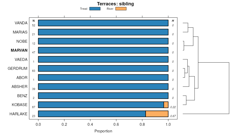
| Marvan silty clay, warm, 2 to 8 percent slopes | 89C | 46026 | 343271 | 2wbxm | mt011 | 1992 | 1:24000 |
Marvan silty clay, warm, 0 to 2 percent slopes | 89A | 43187 | 343270 | 2wbxl | mt011 | 1992 | 1:24000 |
Vanda-Marvan complex, 0 to 2 percent slopes | 197A | 30104 | 343013 | chxy | mt011 | 1992 | 1:24000 |
Vanda-Marvan complex, 2 to 8 percent slopes | 197C | 17887 | 343014 | chxz | mt011 | 1992 | 1:24000 |
Bascovy-Marvan complex, 2 to 8 percent slopes | 590C | 10812 | 343154 | cj2h | mt011 | 1992 | 1:24000 |
Marvan clay, warm, 0 to 6 percent slopes | 614C | 3289 | 343174 | cj34 | mt011 | 1992 | 1:24000 |
Marvan-Vanda clays, warm, 0 to 3 percent slopes | 613B | 1701 | 343172 | cj32 | mt011 | 1992 | 1:24000 |
Marvan-Bascovy clays, warm, 0 to 6 percent slopes | 635C | 1379 | 343193 | cj3r | mt011 | 1992 | 1:24000 |
Marvan-Vanda silty clays, 0 to 4 percent slopes | 621B | 5544 | 343592 | cjjm | mt017 | 1995 | 1:24000 |
Marvan silty clay, warm, 0 to 2 percent slopes | 62A | 4538 | 343594 | 2wbxl | mt017 | 1995 | 1:24000 |
Neldore-Abor-Marvan complex, 2 to 15 percent slopes | 552D | 4389 | 343536 | cjgt | mt017 | 1995 | 1:24000 |
Marvan silty clay, warm, 2 to 8 percent slopes | 62C | 2332 | 343595 | 2wbxm | mt017 | 1995 | 1:24000 |
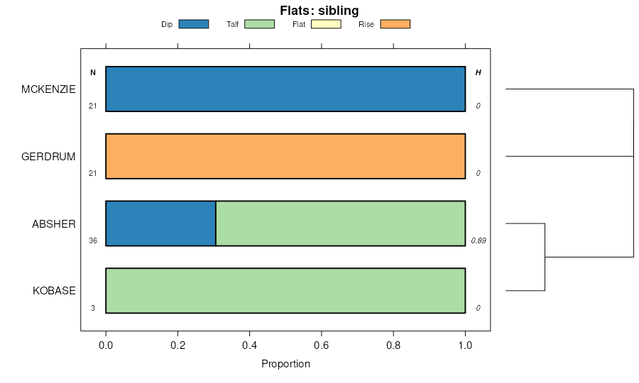
Gerdrum-Marvan silty clays, 2 to 8 percent slopes | 658C | 25 | 343620 | cjkj | mt017 | 1995 | 1:24000 |
Marvan silty clay, warm, 2 to 8 percent slopes | 89C | 5600 | 342308 | 2wbxm | mt025 | 1991 | 1:24000 |
Marvan silty clay, warm, 0 to 2 percent slopes | 89A | 1396 | 342307 | 2wbxl | mt025 | 1991 | 1:24000 |
Marvan silty clay, 2 to 8 percent slopes | 167 | 4729 | 342398 | ch93 | mt027 | 1979 | 1:24000 |
Marvan silty clay, 0 to 2 percent slopes | 166 | 3057 | 342397 | ch92 | mt027 | 1979 | 1:24000 |
Abor-Marvan silty clays, 2 to 8 percent slopes | 37C | 5821 | 342776 | 2xrs7 | mt033 | 2002 | 1:24000 |
Gerdrum-Marvan silty clays, 2 to 8 percent slopes | 555C | 3665 | 342803 | chq5 | mt033 | 2002 | 1:24000 |
Marvan silty clay, warm, 2 to 8 percent slopes | 74C | 3084 | 342695 | 2wbxm | mt033 | 2002 | 1:24000 |
Marvan silty clay, warm, 0 to 2 percent slopes | 74A | 2946 | 342694 | 2wbxl | mt033 | 2002 | 1:24000 |
Marvan-Vanda silty clays, 0 to 8 percent slopes | 741C | 937 | 342775 | chp8 | mt033 | 2002 | 1:24000 |
Marvan complex, 0 to 2 percent slopes | 309A | 5551 | 343898 | cjvh | mt041 | 1994 | 1:24000 |
Marvan clay, 0 to 2 percent slopes | 30A | 3365 | 343899 | cjvj | mt041 | 1994 | 1:24000 |
Marvan-Nobe clays, 0 to 2 percent slopes | 304A | 1311 | 343897 | cjvg | mt041 | 1994 | 1:24000 |
Marvan clay, 2 to 8 percent slopes | 30C | 836 | 343901 | cjvl | mt041 | 1994 | 1:24000 |
Marvan silty clay, 0 to 4 percent slopes | 30B | 14886 | 344173 | ck4c | mt051 | 1992 | 1:24000 |
Marvan clay, 0 to 4 percent slopes | 302B | 2565 | 344170 | ck48 | mt051 | 1992 | 1:24000 |
Marvan silty clay, 4 to 8 percent slopes | 30C | 1778 | 344174 | ck4d | mt051 | 1992 | 1:24000 |
Marvan-Joplin, complex, 0 to 4 percent slopes | 304B | 1364 | 344171 | ck49 | mt051 | 1992 | 1:24000 |
Marvan-Yawdim-Cabbart complex, 4 to 15 percent slopes | 306D | 850 | 344172 | ck4b | mt051 | 1992 | 1:24000 |
Marvan-Vanda complex, 2 to 8 percent slopes | 301C | 680 | 344169 | ck47 | mt051 | 1992 | 1:24000 |
Marvan clay, 0 to 8 percent slopes | 114 | 3616 | 344310 | ck8s | mt055 | 1981 | 1:24000 |
Marvan-Vanda silty clays, 0 to 4 percent slopes | 64A | 21460 | 344614 | cgmb | mt065 | 1996 | 1:24000 |
Marvan silty clay, 0 to 8 percent slopes | 64B | 13570 | 344615 | cgkw | mt065 | 1996 | 1:24000 |
Harlake-Marvan-Vanda silty clays, 0 to 4 percent slopes | 20B | 2690 | 344505 | ckh2 | mt065 | 1996 | 1:24000 |
Marvan-Vanda silty clays, 0 to 8 percent slopes | 60 | 12348 | 344730 | ckqb | mt069 | 1989 | 1:24000 |
Marvan silty clay, 1 to 8 percent slopes | 59 | 7730 | 344728 | ckq8 | mt069 | 1989 | 1:24000 |
Vanda-Harlem-Marvan silty clays, 0 to 4 percent slopes | 86 | 3325 | 344758 | ckr7 | mt069 | 1989 | 1:24000 |
Marvan-Vanda silty clays, 0 to 4 percent slopes | 96 | 1843 | 345052 | cl1q | mt079 | 1986 | 1:24000 |
Marvan silty clay, warm, 0 to 2 percent slopes | 94 | 1716 | 345050 | 2wbxl | mt079 | 1986 | 1:24000 |
Marvan silty clay, warm, 2 to 8 percent slopes | 95 | 1090 | 345051 | 2wbxm | mt079 | 1986 | 1:24000 |
Marvan silty clay, 0 to 4 percent slopes | 30B | 6295 | 345121 | cl3y | mt101 | 1992 | 1:24000 |
Vanda-Marvan, saline, clays, 0 to 2 percent slopes | 482A | 2692 | 345197 | cl6d | mt101 | 1992 | 1:24000 |
Marvan silty clay, 4 to 8 percent slopes | 30C | 741 | 345122 | cl3z | mt101 | 1992 | 1:24000 |
Marvan clay, 0 to 4 percent slopes | 88 | 13950 | 346557 | cmm8 | mt608 | 1976 | 1:24000 |
Bascovy-Marvan silty clays, moist, 2 to 8 percent slopes | 408C | 7940 | 3253389 | 31g3z | mt608 | 1976 | 1:24000 |
Marvan-Bascovy clays, dry, 2 to 8 percent slopes | 407C | 797 | 3253390 | 31g40 | mt608 | 1976 | 1:24000 |
Marvan clay, 0 to 2 percent slopes | 143 | 11770 | 341805 | cgnz | mt613 | 1975 | 1:24000 |
Marvan clay, 2 to 8 percent slopes | 144 | 5981 | 341806 | cgp0 | mt613 | 1975 | 1:24000 |
Marvan clay, wet, 0 to 2 percent slopes | 145 | 2518 | 341807 | cgp1 | mt613 | 1975 | 1:24000 |
Marvan clay, 0 to 4 percent slopes | 30B | 22114 | 346675 | cmr2 | mt615 | 1992 | 1:24000 |
Marvan-Vanda clays, 2 to 8 percent slopes | 301C | 11212 | 346666 | cmqs | mt615 | 1992 | 1:24000 |
Marvan clay, 4 to 8 percent slopes | 30C | 4442 | 346676 | cmr3 | mt615 | 1992 | 1:24000 |
Marvan-Bascovy clays, dry, 2 to 8 percent slopes | 407C | 3193 | 3253388 | 31g40 | mt615 | 1992 | 1:24000 |
Bascovy-Marvan silty clays, moist, 2 to 8 percent slopes | 408C | 2964 | 3253387 | 31g3z | mt615 | 1992 | 1:24000 |
Marvan-Vanda clays, 0 to 2 percent slopes | 301A | 1721 | 346665 | cmqr | mt615 | 1992 | 1:24000 |
Marvan-Nobe clays, 0 to 2 percent slopes | 305A | 1306 | 346673 | cmr0 | mt615 | 1992 | 1:24000 |
Marvan-Vanda silty clays, 0 to 4 percent slopes | 64A | 123 | 3176841 | cgmb | mt624 | 2021 | 1:24000 |
Marvan silty clay, 0 to 8 percent slopes | 64B | 17 | 2513982 | cgkw | mt624 | 2021 | 1:24000 |
Marvan-Vanda clays, 0 to 8 percent slopes | 302B | 65913 | 347662 | cnrx | mt641 | 1994 | 1:24000 |
Harlake-Marvan association, 0 to 4 percent slopes | 1090B | 27317 | 347570 | cnny | mt641 | 1994 | 1:24000 |
Marvan-Gerdrum association, 2 to 15 percent slopes | 1030D | 17847 | 347561 | cnnn | mt641 | 1994 | 1:24000 |
Marvan complex, 2 to 8 percent slopes | 301C | 9106 | 347661 | cnrw | mt641 | 1994 | 1:24000 |
Marvan clay, 0 to 2 percent slopes | 30A | 7859 | 347663 | cnry | mt641 | 1994 | 1:24000 |
Kobase-Marvan-Weingart complex, 0 to 4 percent slopes | 323B | 904 | 347672 | cns7 | mt641 | 1994 | 1:24000 |
Marvan silty clay, warm, 2 to 8 percent slopes | 139 | 22783 | 347963 | 2wbxm | mt649 | 1985 | 1:24000 |
Abor-Marvan silty clays, 2 to 8 percent slopes | 3 | 22536 | 348059 | 2xrs7 | mt649 | 1985 | 1:24000 |
Marvan silty clay, warm, 0 to 2 percent slopes | 138 | 19756 | 347962 | 2wbxl | mt649 | 1985 | 1:24000 |
Gerdrum-Marvan silty clays, 2 to 8 percent slopes | 92 | 6819 | 348128 | cp7y | mt649 | 1985 | 1:24000 |
Marvan silty clay, saline, 2 to 8 percent slopes | 140 | 6122 | 347965 | cp2p | mt649 | 1985 | 1:24000 |
Marvan silty clay, wet, 0 to 4 percent slopes | 540B | 18337 | 348713 | cpvt | mt657 | 1990 | 1:24000 |
Marvan, wet-Trudau complex, 0 to 8 percent slopes | 722C | 7550 | 348789 | cpy8 | mt657 | 1990 | 1:24000 |
Marvan clay, 0 to 4 percent slopes | 45B | 2926 | 348663 | cpt6 | mt657 | 1990 | 1:24000 |
Marvan, wet-Nobe silty clays, 0 to 2 percent slopes | 145A | 1036 | 348352 | cph5 | mt657 | 1990 | 1:24000 |
Vanda-Marvan clays, 0 to 2 percent slopes | 160A | 547 | 348371 | cphs | mt657 | 1990 | 1:24000 |
Marvan-Vanda silty clays, 0 to 4 percent slopes | 64A | 4289 | 341754 | cgmb | mt666 | 2008 | 1:24000 |
Marvan silty clay, 0 to 8 percent slopes | 64B | 3691 | 341709 | cgkw | mt666 | 2008 | 1:24000 |
Taylordraw-Alkalicreek-Marvan complex, 0 to 4 percent slopes | 762 | 13211 | 3410485 | 31g9m | wy630 | | 1:24000 |


