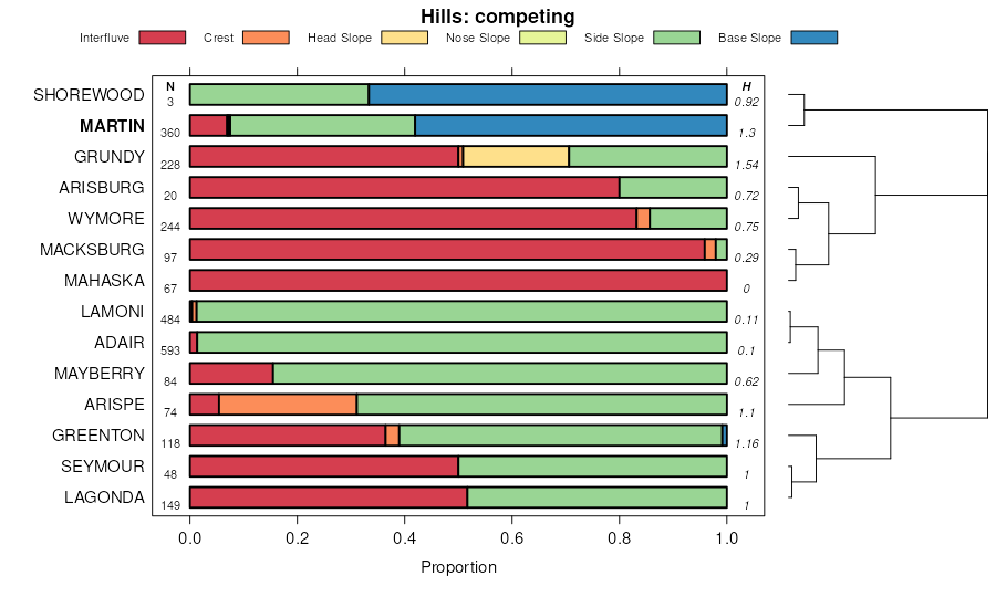
| Martin silty clay loam, 3 to 7 percent slopes | 7302 | 3002 | 1475360 | 2v8zn | ks005 | 1998 | 1:24000 |
Martin silty clay loam, 3 to 7 percent slopes, eroded | 7303 | 251 | 2420271 | 2v8zp | ks005 | 1998 | 1:24000 |
Martin silty clay loam, 7 to 12 percent slopes, eroded | 7305 | 15 | 2420273 | 2v8zr | ks005 | 1998 | 1:24000 |
Padonia-Martin silty clay loams, 5 to 9 percent slopes | 7470 | 6 | 1475362 | 1lj7b | ks005 | 1998 | 1:24000 |
Martin-Oska silty clay loams, 3 to 6 percent slopes | 7325 | 4 | 1475361 | 2v8zx | ks005 | 1998 | 1:24000 |
Padonia-Martin silty clay loams, 5 to 9 percent slopes | 7470 | 11204 | 1152176 | 17nxz | ks013 | 1994 | 1:24000 |
Padonia-Martin silty clay loams, 9 to 25 percent slopes | 7471 | 2755 | 1152177 | 17ny0 | ks013 | 1994 | 1:24000 |
Martin silty clay loam, 1 to 3 percent slopes | 7301 | 901 | 1152171 | 2v8zm | ks013 | 1994 | 1:24000 |
Martin silty clay loam, 3 to 7 percent slopes, eroded | 7303 | 130 | 1152172 | 2v8zp | ks013 | 1994 | 1:24000 |
Martin silty clay loam, 7 to 12 percent slopes | 7304 | 15 | 1479261 | 2v8zq | ks013 | 1994 | 1:24000 |
Florence-Martin complex, 2 to 12 percent slopes | 4660 | 2029 | 1382869 | 2tt4t | ks015 | 1970 | 1:24000 |
Martin silty clay loam, 3 to 7 percent slopes | 7302 | 69 | 1382891 | 2wtvx | ks015 | 1970 | 1:24000 |
Martin silty clay loam, 1 to 3 percent slopes | 7301 | 51 | 1382890 | 2wtvw | ks015 | 1970 | 1:24000 |
Martin silty clay loam, 3 to 7 percent slopes | 7302 | 5997 | 1382839 | 2wtvx | ks017 | 1967 | 1:24000 |
Martin silty clay loam, 3 to 7 percent slopes, eroded | 7303 | 2362 | 1382840 | 2wtvy | ks017 | 1967 | 1:24000 |
Martin-Gullied land complex, 3 to 10 percent slopes | 7315 | 413 | 1382841 | 2wtw1 | ks017 | 1967 | 1:24000 |
Martin-Dwight silty clay loams, 1 to 3 percent slopes | 7310 | 13985 | 1453386 | 2wtw0 | ks019 | 1972 | 1:24000 |
Martin silty clay loam, 3 to 7 percent slopes | 7302 | 12946 | 1453383 | 2wtvx | ks019 | 1972 | 1:24000 |
Martin silty clay loam, 1 to 3 percent slopes | 7301 | 10920 | 1453382 | 2wtvw | ks019 | 1972 | 1:24000 |
Martin silty clay loam, 3 to 7 percent slopes, eroded | 7303 | 10289 | 1453384 | 2wtvy | ks019 | 1972 | 1:24000 |
Martin silty clay, 3 to 7 percent slopes, eroded | 7306 | 307 | 1453385 | 2wtvz | ks019 | 1972 | 1:24000 |
Martin silty clay loam, 0 to 1 percent slopes | 7300 | 225 | 1453381 | 2wtvv | ks019 | 1972 | 1:24000 |
Martin silty clay loam, 3 to 7 percent slopes | 7302 | 39902 | 1382944 | 2wtvx | ks035 | 1977 | 1:24000 |
Martin-Florence complex, 2 to 12 percent slopes | 7312 | 30714 | 1382946 | 2tt4w | ks035 | 1977 | 1:24000 |
Martin silty clay loam, 1 to 3 percent slopes | 7301 | 12450 | 1382943 | 2wtvw | ks035 | 1977 | 1:24000 |
Martin silty clay loam, 3 to 7 percent slopes, eroded | 7303 | 7172 | 1382945 | 2wtvy | ks035 | 1977 | 1:24000 |
Florence-Martin complex, 2 to 12 percent slopes | 4660 | 1921 | 1382931 | 2tt4t | ks035 | 1977 | 1:24000 |
Martin silty clay loam, 3 to 7 percent slopes, eroded | 7303 | 452 | 747167 | 2v8zp | ks043 | 1977 | 1:24000 |
Martin silty clay loam, 7 to 12 percent slopes | 7304 | 181 | 791537 | 2v8zq | ks043 | 1977 | 1:24000 |
Martin silty clay loam, 3 to 7 percent slopes | 7302 | 41953 | 1468833 | 2v8zn | ks045 | 1974 | 1:24000 |
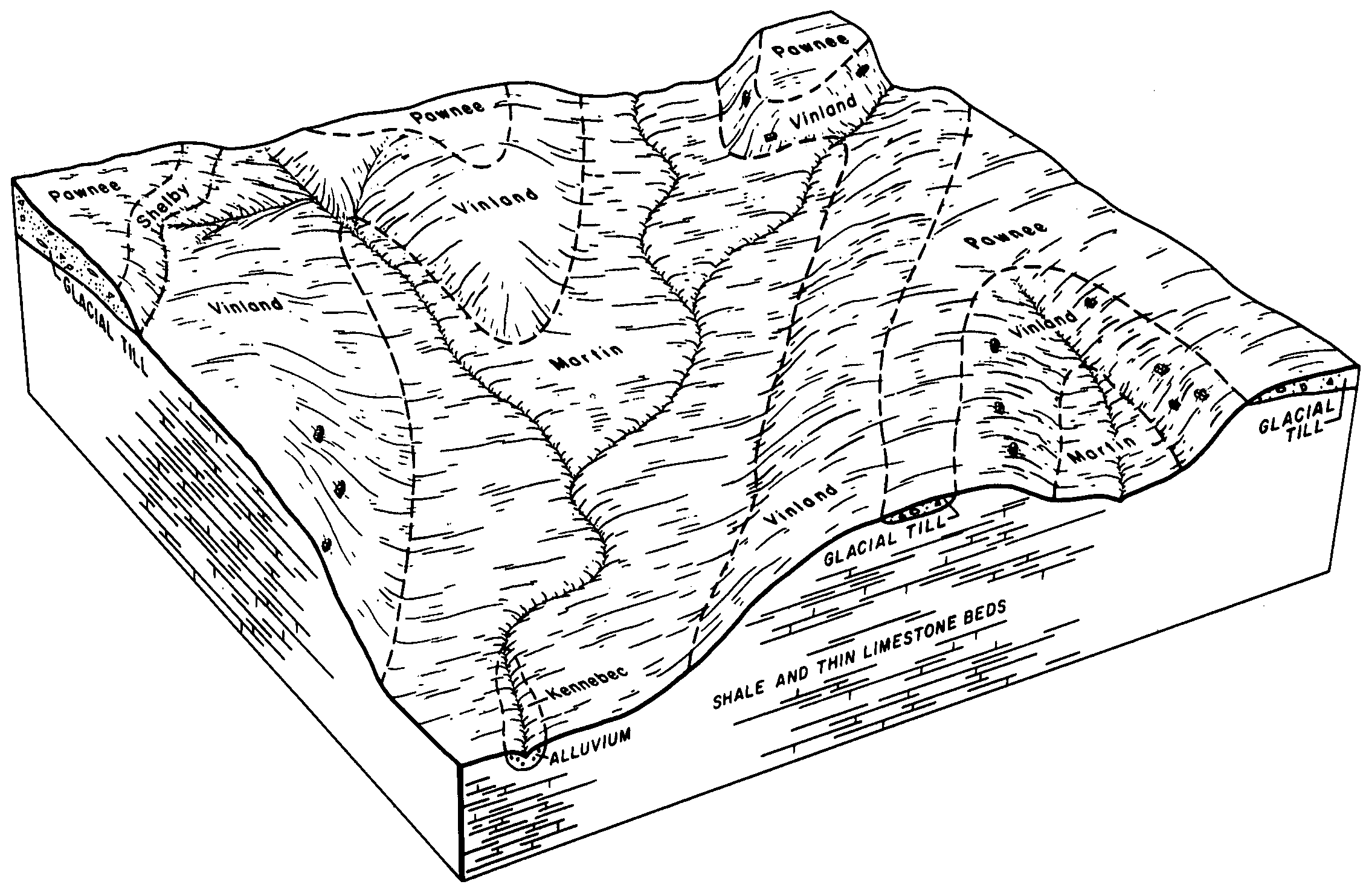
Vinland-Martin complex, 7 to 15 percent slopes | 7657 | 18899 | 1468857 | 2yrw2 | ks045 | 1974 | 1:24000 |
Martin-Oska silty clay loams, 3 to 6 percent slopes | 7325 | 13917 | 1468836 | 2v8zx | ks045 | 1974 | 1:24000 |
Martin soils, 3 to 7 percent slopes, eroded | 7307 | 7336 | 1468835 | 2v8zt | ks045 | 1974 | 1:24000 |
Martin silty clay loam, 1 to 3 percent slopes | 7301 | 4400 | 1468832 | 2v8zm | ks045 | 1974 | 1:24000 |
Martin silty clay loam, 7 to 12 percent slopes, eroded | 7305 | 133 | 2421224 | 2v8zr | ks045 | 1974 | 1:24000 |
Martin silty clay loam, 7 to 12 percent slopes | 7304 | 15 | 1468834 | 2v8zq | ks045 | 1974 | 1:24000 |
Martin silty clay loam, 1 to 3 percent slopes | 7301 | 16354 | 1453317 | 2wtvw | ks049 | 1984 | 1:24000 |
Florence-Martin complex, 2 to 12 percent slopes | 4660 | 9402 | 1453303 | 2tt4t | ks049 | 1984 | 1:24000 |
Martin silty clay loam, 3 to 7 percent slopes | 7302 | 5191 | 1453318 | 2wtvx | ks049 | 1984 | 1:24000 |
Martin silty clay, 3 to 7 percent slopes, eroded | 7306 | 1061 | 1453319 | 2wtvz | ks049 | 1984 | 1:24000 |
Martin silty clay loam, 1 to 3 percent slopes | 7301 | 27729 | 1453659 | 2wtvw | ks073 | 1981 | 1:24000 |
Martin silty clay loam, 3 to 7 percent slopes | 7302 | 19865 | 1453660 | 2wtvx | ks073 | 1981 | 1:24000 |
Martin silty clay, 3 to 7 percent slopes, eroded | 7306 | 1344 | 1453661 | 2wtvz | ks073 | 1981 | 1:24000 |
Florence-Martin complex, 2 to 12 percent slopes | 4660 | 668 | 1453647 | 2tt4t | ks073 | 1981 | 1:24000 |
Martin silty clay loam, 3 to 7 percent slopes | 7302 | 40445 | 1480348 | 2v8zn | ks085 | 1976 | 1:24000 |
Martin-Vinland silty clay loams, 5 to 10 percent slopes | 7330 | 24210 | 1480352 | 2v8zy | ks085 | 1976 | 1:24000 |
Martin silty clay loam, 3 to 7 percent slopes, eroded | 7303 | 23422 | 1480349 | 2v8zp | ks085 | 1976 | 1:24000 |
Martin-Oska silty clay loams, 3 to 6 percent slopes | 7325 | 56 | 1480351 | 1lpf8 | ks085 | 1976 | 1:24000 |
Martin silty clay loam, 7 to 12 percent slopes | 7304 | 51 | 1480350 | 2v8zq | ks085 | 1976 | 1:24000 |
Martin silty clay loam, 1 to 3 percent slopes | 7301 | 7 | 1480347 | 2v8zm | ks085 | 1976 | 1:24000 |
Martin silty clay loam, 3 to 7 percent slopes | 7302 | 25096 | 1480056 | 2v8zn | ks087 | 1974 | 1:24000 |
Martin-Oska silty clay loams, 3 to 6 percent slopes | 7325 | 14700 | 1480058 | 2v8zx | ks087 | 1974 | 1:24000 |
Martin soils, 3 to 7 percent slopes, eroded | 7307 | 3962 | 1480057 | 2v8zt | ks087 | 1974 | 1:24000 |
Martin silty clay loam, 3 to 7 percent slopes, eroded | 7303 | 1729 | 2420266 | 2v8zp | ks087 | 1974 | 1:24000 |
Martin silty clay loam, 1 to 3 percent slopes | 7301 | 726 | 1480055 | 2v8zm | ks087 | 1974 | 1:24000 |
Vinland-Martin complex, 7 to 15 percent slopes | 7657 | 164 | 1480079 | 2yrw2 | ks087 | 1974 | 1:24000 |
Martin silty clay loam, 7 to 12 percent slopes, eroded | 7305 | 50 | 2420274 | 2v8zr | ks087 | 1974 | 1:24000 |
Martin-Vinland silty clay loams, 5 to 10 percent slopes | 7330 | 25 | 1480059 | 2v8zy | ks087 | 1974 | 1:24000 |
Oska-Martin silty clay loams, 4 to 8 percent slopes | 7462 | 45658 | 766065 | 2v8zh | ks091 | 1976 | 1:24000 |
Martin silty clay loam, 3 to 7 percent slopes | 7302 | 9973 | 766060 | 2v8zn | ks091 | 1976 | 1:24000 |
Martin-Vinland silty clay loams, 5 to 10 percent slopes | 7330 | 1448 | 766061 | 2v8zy | ks091 | 1976 | 1:24000 |
Martin silty clay loam, 3 to 7 percent slopes, eroded | 7303 | 15071 | 2420269 | 2v8zp | ks103 | 1973 | 1:24000 |
Martin silty clay loam, 7 to 12 percent slopes, eroded | 7305 | 3582 | 1862377 | 2v8zr | ks103 | 1973 | 1:24000 |
Martin silty clay loam, 3 to 7 percent slopes | 7302 | 1891 | 1862375 | 2v8zn | ks103 | 1973 | 1:24000 |
Martin silty clay loam, 1 to 3 percent slopes | 7301 | 1860 | 2420257 | 2v8zm | ks103 | 1973 | 1:24000 |
Martin silty clay loam, 3 to 7 percent slopes | 7302 | 23490 | 1453725 | 2wtvx | ks111 | 1977 | 1:24000 |
Martin silty clay loam, 1 to 3 percent slopes | 7301 | 10729 | 1453724 | 2wtvw | ks111 | 1977 | 1:24000 |
Martin silty clay, 3 to 7 percent slopes, eroded | 7306 | 10223 | 1453726 | 2wtvz | ks111 | 1977 | 1:24000 |
Oska-Martin silty clay loams, 4 to 8 percent slopes | 7462 | 421 | 1468937 | 2v8zh | ks121 | 1979 | 1:24000 |
Padonia-Martin silty clay loams, 5 to 9 percent slopes | 7470 | 2010 | 1406027 | 1j62q | ks131 | 1980 | 1:24000 |
Martin silty clay loam, 1 to 3 percent slopes | 7301 | 2 | 1406021 | 2v8zm | ks131 | 1980 | 1:24000 |
Martin silty clay loam, 3 to 7 percent slopes | 7302 | 2629 | 1454771 | 2v8zn | ks139 | 1983 | 1:24000 |
Vinland-Martin complex, 7 to 15 percent slopes | 7657 | 434 | 1454778 | 2yrw2 | ks139 | 1983 | 1:24000 |
Martin-Kennebec complex, 0 to 12 percent slopes | 7320 | 59 | 1454773 | 2v8zw | ks139 | 1983 | 1:24000 |
Martin silty clay loam, 7 to 12 percent slopes | 7304 | 58 | 1454772 | 2v8zq | ks139 | 1983 | 1:24000 |
Martin-Oska silty clay loams, 3 to 6 percent slopes | 7325 | 37 | 1454774 | 2v8zx | ks139 | 1983 | 1:24000 |
Dwight-Martin silty clay loams, 1 to 3 percent slopes | 4635 | 4 | 1454757 | 2wtwk | ks139 | 1983 | 1:24000 |
Martin silty clay loam, 3 to 7 percent slopes | 7302 | 1452 | 1480717 | 2v8zn | ks149 | 1984 | 1:24000 |
Martin silty clay loam, 3 to 7 percent slopes | 7302 | 52098 | 1473497 | 2v8zn | ks177 | 1966 | 1:24000 |
Martin silty clay loam, 3 to 7 percent slopes, eroded | 7303 | 13421 | 1473498 | 2v8zp | ks177 | 1966 | 1:24000 |
Martin silty clay loam, 1 to 3 percent slopes | 7301 | 9714 | 1473496 | 2v8zm | ks177 | 1966 | 1:24000 |
Martin-Kennebec complex, 0 to 12 percent slopes | 7320 | 7469 | 1473502 | 2v8zw | ks177 | 1966 | 1:24000 |
Martin silty clay loam, 7 to 12 percent slopes | 7304 | 7415 | 1473499 | 2v8zq | ks177 | 1966 | 1:24000 |
Dwight-Martin silty clay loams, 1 to 3 percent slopes | 4635 | 2530 | 1473456 | 2wtwk | ks177 | 1966 | 1:24000 |
Martin silty clay loam, 7 to 12 percent slopes, eroded | 7305 | 1176 | 1473500 | 2v8zr | ks177 | 1966 | 1:24000 |
Martin soils, 3 to 7 percent slopes, severely eroded | 7308 | 236 | 1473501 | 2v8zv | ks177 | 1966 | 1:24000 |
Vinland-Martin complex, 7 to 15 percent slopes | 7657 | 69 | 1473530 | 2yrw2 | ks177 | 1966 | 1:24000 |
Martin-Vinland silty clay loams, 5 to 10 percent slopes | 7330 | 13 | 1473503 | 2v8zy | ks177 | 1966 | 1:24000 |
Martin silty clay loam, 3 to 7 percent slopes | 7302 | 74165 | 1472172 | 2v8zn | ks197 | 1988 | 1:24000 |
Martin silty clay loam, 3 to 7 percent slopes, eroded | 7303 | 4848 | 1472173 | 2v8zp | ks197 | 1988 | 1:24000 |
Martin silty clay, 3 to 7 percent slopes, eroded | 7306 | 47 | 1472175 | 2wtvz | ks197 | 1988 | 1:24000 |
Martin silty clay loam, 7 to 12 percent slopes, eroded | 7305 | 8 | 1472174 | 2v8zr | ks197 | 1988 | 1:24000 |
Martin-Kennebec complex, 0 to 12 percent slopes | 7320 | 5 | 1472176 | 2v8zw | ks197 | 1988 | 1:24000 |
Martin silty clay loam, 1 to 3 percent slopes | 7301 | 1 | 1472171 | 2v8zm | ks197 | 1988 | 1:24000 |
Martin silty clay loam, 1 to 3 percent slopes | 7301 | 156 | 1427167 | 2wtvw | ks207 | 1973 | 1:20000 |
Martin silty clay loam, 3 to 7 percent slopes | 7302 | 249 | 1862263 | 2v8zn | ks209 | 1973 | 1:24000 |
Martin silty clay loam, 7 to 12 percent slopes, eroded | 7305 | 182 | 1862265 | 2v8zr | ks209 | 1973 | 1:24000 |