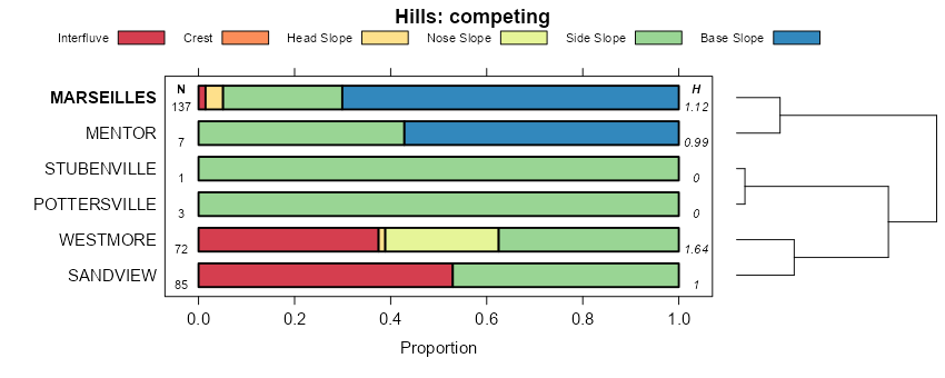
| Marseilles silt loam, 18 to 35 percent slopes | 549F | 2431 | 2378634 | 30t8b | il001 | 1997 | 1:12000 |
Marseilles silt loam, 35 to 60 percent slopes | 549G | 864 | 2378635 | 31dzr | il001 | 1997 | 1:12000 |
Marseilles silt loam, 10 to 18 percent slopes, eroded | 549D2 | 753 | 2378632 | 31dzp | il001 | 1997 | 1:12000 |
Marseilles silty clay loam, 10 to 18 percent slopes, severely eroded | 549D3 | 136 | 2378633 | 31dzq | il001 | 1997 | 1:12000 |
Marseilles silt loam, 35 to 60 percent slopes | 549G | 8249 | 172988 | 31dzr | il009 | 1984 | 1:12000 |
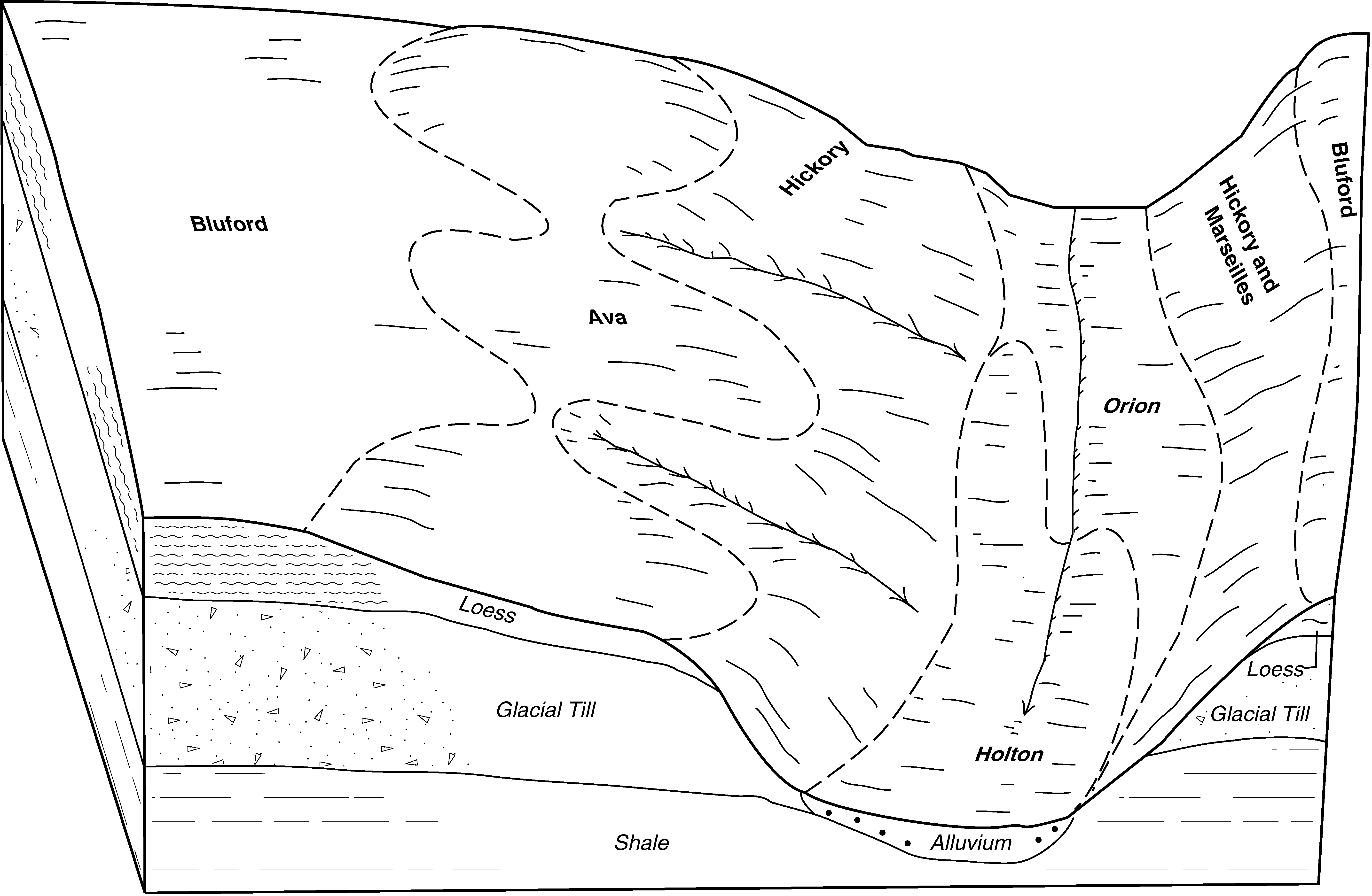
Hickory-Marseilles silt loams, 18 to 35 percent slopes | 966F | 3589 | 173007 | 5t0w | il009 | 1984 | 1:12000 |
Marseilles silt loam, 18 to 35 percent slopes | 549F | 2618 | 172987 | 30t8b | il009 | 1984 | 1:12000 |
Marseilles silt loam, 18 to 35 percent slopes, eroded | 549F2 | 264 | 2604190 | 30t8c | il009 | 1984 | 1:12000 |
Marseilles silt loam, 2 to 5 percent slopes, eroded | 549B2 | 640 | 1862752 | 30t85 | il011 | 2007 | 1:12000 |
Marseilles silt loam, 35 to 60 percent slopes | 549G | 520 | 1862754 | 31dzr | il011 | 2007 | 1:12000 |
Marseilles silt loam, 5 to 10 percent slopes, eroded | 549C2 | 499 | 1862753 | 30t86 | il011 | 2007 | 1:12000 |
Hickory-Marseilles complex, 15 to 30 percent slopes | 913F | 955 | 174876 | 5vz5 | il035 | 1992 | 1:15840 |
Hickory-Marseilles complex, 30 to 60 percent slopes | 913G | 906 | 174877 | 5vz6 | il035 | 1992 | 1:15840 |
Marseilles silt loam, 35 to 60 percent slopes | 549G | 2242 | 615665 | 31dzr | il057 | 1997 | 1:12000 |
Marseilles silt loam, 18 to 35 percent slopes | 549F | 1746 | 615664 | 30t8b | il057 | 1997 | 1:12000 |
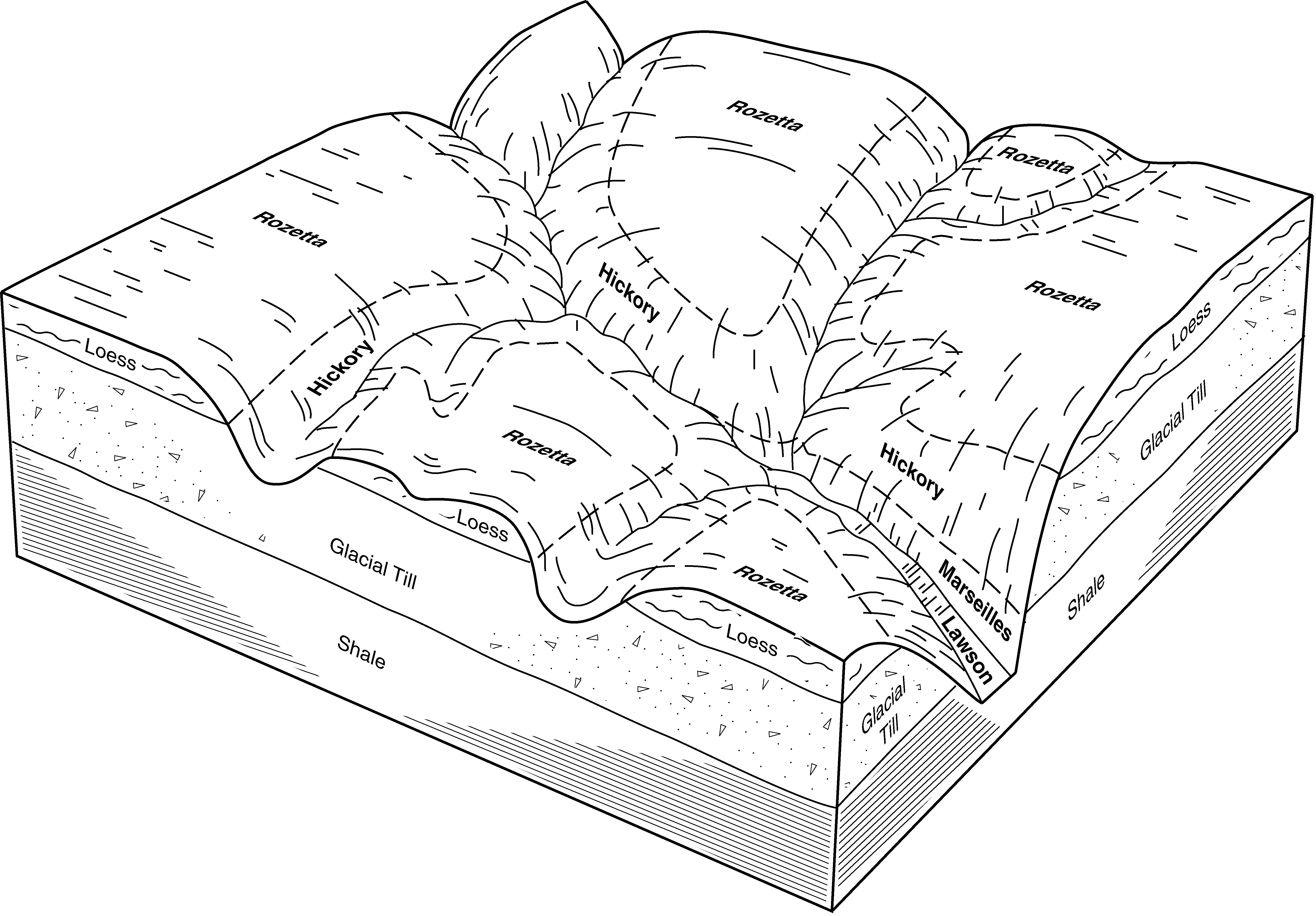
Marseilles-Hickory complex, 18 to 35 percent slopes, eroded | 913F2 | 1272 | 244836 | 86ry | il073 | 2001 | 1:12000 |
Marseilles silt loam, 10 to 18 percent slopes, eroded | 549D2 | 852 | 244791 | 31dzp | il073 | 2001 | 1:12000 |
Marseilles-Hickory complex, 10 to 18 percent slopes, severely eroded | 913D3 | 788 | 244834 | 86rw | il073 | 2001 | 1:12000 |
Marseilles silt loam, 18 to 35 percent slopes, eroded | 549F2 | 663 | 244793 | 30t8c | il073 | 2001 | 1:12000 |
Marseilles-Hickory silt loams, 10 to 18 percent slopes | 913D | 548 | 244833 | 86rv | il073 | 2001 | 1:12000 |
Marseilles-Atlas silty clay loams, 10 to 18 percent slopes, severely eroded | 918D3 | 497 | 244841 | 86s3 | il073 | 2001 | 1:12000 |
Marseilles silt loam, 18 to 35 percent slopes | 549F | 48 | 643552 | 30t8b | il073 | 2001 | 1:12000 |
Marseilles-Hickory silt loams, 18 to 35 percent slopes | 913F | 25 | 244835 | 86rx | il073 | 2001 | 1:12000 |
Marseilles silt loam, 35 to 60 percent slopes | 549G | 6787 | 680995 | 31dzr | il095 | 2002 | 1:12000 |
Marseilles silt loam, 18 to 35 percent slopes | 549F | 5672 | 680994 | 30t8b | il095 | 2002 | 1:12000 |
Marseilles silt loam, 10 to 18 percent slopes, eroded | 549D2 | 793 | 680993 | 31dzp | il095 | 2002 | 1:12000 |
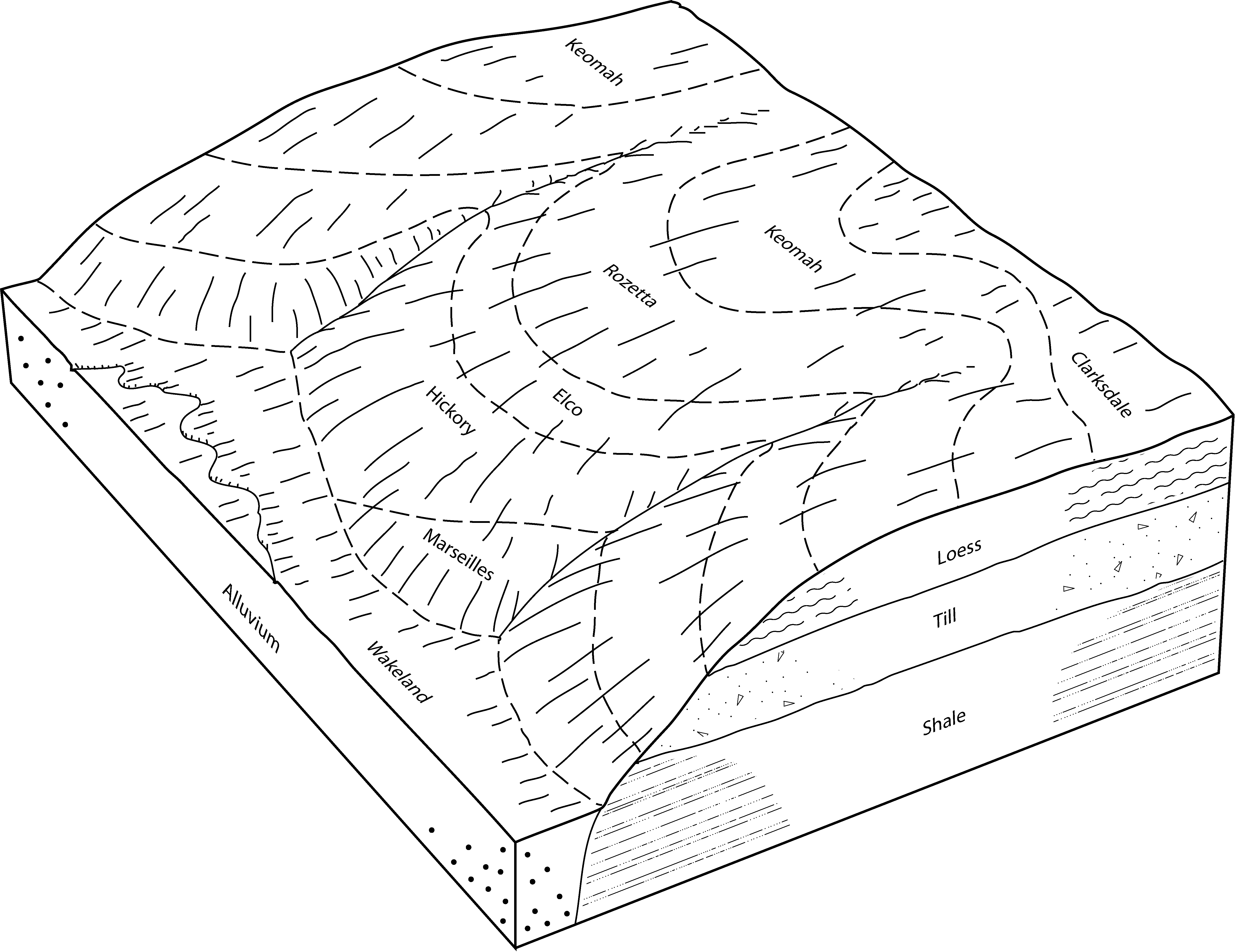
Marseilles, Northfield, and Ritchey silt loams, 30 to 60 percent slopes | 794G | 4354 | 1386895 | 1hk5k | il099 | 2006 | 1:12000 |
Marseilles silt loam, 18 to 35 percent slopes | 549F | 1132 | 1427820 | 30t8b | il099 | 2006 | 1:12000 |
Marseilles silt loam, 2 to 5 percent slopes | 549B | 915 | 1427810 | 30t87 | il099 | 2006 | 1:12000 |
Marseilles silt loam, 5 to 10 percent slopes, eroded | 549C2 | 858 | 1427816 | 30t86 | il099 | 2006 | 1:12000 |
Marseilles silt loam, 35 to 60 percent slopes | 549G | 799 | 1608828 | 31dzr | il099 | 2006 | 1:12000 |
Marseilles silt loam, 10 to 18 percent slopes, eroded | 549D2 | 526 | 1427818 | 31dzp | il099 | 2006 | 1:12000 |
Marseilles silt loam, 35 to 60 percent slopes | 549G | 1785 | 634205 | 31dzr | il109 | 2002 | 1:12000 |
Marseilles silt loam, 18 to 35 percent slopes | 549F | 322 | 634202 | 30t8b | il109 | 2002 | 1:12000 |
Marseilles silt loam, 35 to 60 percent slopes | 549G | 500 | 182214 | 31dzr | il123 | 1997 | 1:15840 |
Marseilles-Hickory silt loams, 18 to 35 percent slopes | 913F | 2821 | 245013 | 86yn | il131 | 2000 | 1:12000 |
Marseilles silt loam, 18 to 35 percent slopes | 549F | 1367 | 244993 | 30t8b | il131 | 2000 | 1:12000 |
Marseilles silt loam, 10 to 18 percent slopes, eroded | 549D2 | 1147 | 244991 | 31dzp | il131 | 2000 | 1:12000 |
Marseilles silt loam, 5 to 10 percent slopes, eroded | 549C2 | 811 | 244990 | 30t86 | il131 | 2000 | 1:12000 |
Marseilles silty clay loam, 10 to 18 percent slopes, severely eroded | 549D3 | 571 | 244992 | 31dzq | il131 | 2000 | 1:12000 |
Marseilles silt loam, 35 to 60 percent slopes | 549G | 7532 | 208997 | 31dzr | il143 | 1986 | 1:15840 |
Marseilles silt loam, 18 to 35 percent slopes | 549F | 4517 | 208996 | 30t8b | il143 | 1986 | 1:15840 |
Marseilles silt loam, 5 to 10 percent slopes, eroded | 549C2 | 72 | 208995 | 30t86 | il143 | 1986 | 1:15840 |
Marseilles silt loam, 35 to 60 percent slopes | 549G | 1267 | 201307 | 31dzr | il149 | 2001 | 1:12000 |
Marseilles silt loam, 18 to 25 percent slopes, eroded | 549E2 | 914 | 201306 | 30t88 | il149 | 2001 | 1:12000 |
Marseilles silt loam, 18 to 35 percent slopes | 549F | 65 | 207281 | 30t8b | il149 | 2001 | 1:12000 |
Marseilles-Hickory silt loams, 35 to 60 percent slopes | 913G | 2725 | 198761 | 6ntn | il161 | 2002 | 1:12000 |
Marseilles-Hickory silt loams, 18 to 35 percent slopes | 913F | 2399 | 198760 | 6ntm | il161 | 2002 | 1:12000 |
Marseilles-Hickory silt loams, 10 to 18 percent slopes, eroded | 913D2 | 579 | 198759 | 6ntl | il161 | 2002 | 1:12000 |
Marseilles silt loam, 35 to 60 percent slopes | 549G | 633 | 199323 | 31dzr | il167 | 1999 | 1:12000 |
Marseilles silt loam, 35 to 60 percent slopes | 549G | 5327 | 202222 | 31dzr | il169 | 2000 | 1:12000 |
Marseilles silt loam, 18 to 35 percent slopes | 549F | 1127 | 202221 | 30t8b | il169 | 2000 | 1:12000 |
Marseilles silt loam, 18 to 35 percent slopes | 549F | 569 | 179109 | 30t8b | il175 | 1992 | 1:15840 |
Marseilles silt loam, 10 to 18 percent slopes, eroded | 549D2 | 375 | 179108 | 31dzp | il175 | 1992 | 1:15840 |
Marseilles silt loam, 35 to 60 percent slopes | 549G | 249 | 179110 | 31dzr | il175 | 1992 | 1:15840 |
Marseilles silt loam, 5 to 10 percent slopes, eroded | 549C2 | 103 | 179107 | 30t86 | il175 | 1992 | 1:15840 |
Marseilles loam, 40 to 80 percent slopes | 549G | 1296 | 1601080 | 1qr1r | il183 | 2006 | 1:12000 |
Marseilles silt loam, 18 to 35 percent slopes | 549F | 1564 | 244896 | 30t8b | il187 | 2002 | 1:12000 |
Marseilles silt loam, 35 to 60 percent slopes | 549G | 1123 | 244897 | 31dzr | il187 | 2002 | 1:12000 |
Marseilles silt loam, 10 to 18 percent slopes, eroded | 549D2 | 868 | 244895 | 31dzp | il187 | 2002 | 1:12000 |