| Madison gravelly clay loam, 6 to 10 percent slopes, severely eroded | MbC3 | 9441 | 122751 | 2tx3m | al017 | 1957 | 1:20000 |
Madison gravelly clay loam, 10 to 15 percent slopes, severely eroded | MbD3 | 7556 | 122753 | 2tx3l | al017 | 1957 | 1:20000 |
Madison gravelly fine sandy loam, 10 to 15 percent slopes, moderately eroded | McD2 | 1365 | 122758 | 2tx3q | al017 | 1957 | 1:20000 |
Madison clay loam, severely eroded, gently sloping | MaB3 | 1206 | 122750 | 43qp | al017 | 1957 | 1:20000 |
Madison gravelly clay loam, very severely eroded, strongly sloping | MbD4 | 940 | 122754 | 43qt | al017 | 1957 | 1:20000 |
Madison gravelly clay loam, severely eroded, moderately steep | MbE3 | 771 | 122755 | 43qv | al017 | 1957 | 1:20000 |
Madison gravelly fine sandy loam, 15 to 25 percent slopes | McE | 761 | 122759 | 2tx3r | al017 | 1957 | 1:20000 |
Madison soils, eroded, strongly sloping, graphitic | MdD2 | 655 | 122761 | 43r1 | al017 | 1957 | 1:20000 |
Madison gravelly fine sandy loam, eroded, gently sloping | McB2 | 364 | 122756 | 43qw | al017 | 1957 | 1:20000 |
Madison gravelly fine sandy loam, 6 to 10 percent slopes, moderately eroded | McC2 | 339 | 122757 | 2tx3p | al017 | 1957 | 1:20000 |
Madison gravelly clay loam, very severely eroded, sloping | MbC4 | 339 | 122752 | 43qr | al017 | 1957 | 1:20000 |
Madison soils, sloping, graphitic | MdC | 218 | 122760 | 43r0 | al017 | 1957 | 1:20000 |
Tallapoosa-Madison association, steep | TmF | 29525 | 328551 | c0wf | al021 | 1967 | 1:20000 |
Madison gravelly loam, 6 to 10 percent slopes, eroded | MdC2 | 8057 | 328528 | c0vp | al021 | 1967 | 1:20000 |
Madison gravelly loam, 10 to 15 percent slopes, eroded | MdD2 | 5716 | 328529 | c0vq | al021 | 1967 | 1:20000 |
Madison gravelly loam, 2 to 6 percent slopes, eroded | MdB2 | 2161 | 328527 | c0vn | al021 | 1967 | 1:20000 |
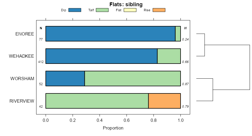
Madison-Riverview association, hilly | MRD | 80238 | 122788 | 43rx | al027 | 1971 | 1:20000 |
Madison-Tallapoosa-Tusquitee association, steep | MTE | 65679 | 122789 | 43ry | al027 | 1971 | 1:20000 |
Madison gravelly sandy loam, 6 to 10 percent slopes | MdC | 13564 | 122791 | 2tx4j | al027 | 1971 | 1:20000 |
Madison loam, 2 to 6 percent slopes | MaB | 939 | 122790 | 43rz | al027 | 1971 | 1:20000 |
Madison association, hilly | MAH | 31539 | 122802 | 43sc | al029 | 1974 | 1:24000 |
Madison-Louisa association, steep | MLS | 25675 | 122803 | 43sd | al029 | 1974 | 1:24000 |
Madison gravelly sandy loam, 6 to 10 percent slopes | MaC | 4764 | 122801 | 2tx4j | al029 | 1974 | 1:24000 |
Madison-Louisa complex, 15 to 30 percent slopes, moderately eroded | MdE2 | 60920 | 1895730 | 2tx3s | al037 | 2006 | 1:24000 |
Bethlehem-Madison complex, 6 to 15 percent slopes, moderately eroded | BmD2 | 22123 | 1895712 | 21mn0 | al037 | 2006 | 1:24000 |
Madison fine sandy loam, 6 to 15 percent slopes, moderately eroded | MaD2 | 17233 | 1895729 | 2tx4h | al037 | 2006 | 1:24000 |
Madison fine sandy loam, 2 to 6 percent slopes, moderately eroded | MaB2 | 4064 | 1895728 | 21mnj | al037 | 2006 | 1:24000 |
Madison gravelly clay loam, 10 to 15 percent slopes, severely eroded | MaD3 | 37205 | 122861 | 2tx3l | al111 | 1965 | 1:15840 |
Madison gravelly fine sandy loam, 6 to 10 percent slopes, moderately eroded | MdC2 | 32099 | 122864 | 2tx3p | al111 | 1965 | 1:15840 |
Madison gravelly clay loam, 6 to 10 percent slopes, severely eroded | MaC3 | 28682 | 122860 | 2tx3m | al111 | 1965 | 1:15840 |
Madison gravelly fine sandy loam, 2 to 6 percent slopes, eroded | MdB2 | 3800 | 122863 | 43vb | al111 | 1965 | 1:15840 |
Madison gravelly fine sandy loam, 10 to 15 percent slopes, moderately eroded | MdD2 | 1996 | 122865 | 2tx3q | al111 | 1965 | 1:15840 |
Cecil-Madison-Urban land complex | Cm | 1344 | 122833 | 43tc | al111 | 1965 | 1:15840 |
Madison gravelly clay loam, 2 to 6 percent slopes, severely eroded | MaB3 | 1068 | 122859 | 43v6 | al111 | 1965 | 1:15840 |
Madison gravelly fine sandy loam, 15 to 25 percent slopes, eroded | MdE2 | 770 | 122866 | 43vf | al111 | 1965 | 1:15840 |
Madison gravelly clay loam, 15 to 25 percent slopes, severely eroded | MaE3 | 441 | 122862 | 43v9 | al111 | 1965 | 1:15840 |
Madison-Louisa complex, 15 to 30 percent slopes, moderately eroded | MdE2 | 31930 | 1476430 | 2tx3s | al123 | 2005 | 1:24000 |
Madison fine sandy loam, 6 to 15 percent slopes, moderately eroded | MaD2 | 31247 | 1476429 | 2tx4h | al123 | 2005 | 1:24000 |
Madison fine sandy loam, 2 to 6 percent slopes, moderately eroded | MaB2 | 10643 | 1476427 | 1lkbp | al123 | 2005 | 1:24000 |
Madison sandy clay loam, 6 to 15 percent slopes, severely eroded | MdD3 | 9620 | 1018592 | 2tx3t | ga035 | 2003 | 1:24000 |
Madison-Bethlehem complex, 6 to 15 percent slopes, stony | MsD | 2460 | 1018594 | 135xw | ga035 | 2003 | 1:24000 |
Madison sandy clay loam, 15 to 30 percent slopes, severely eroded | MdE3 | 1470 | 1018593 | 135xv | ga035 | 2003 | 1:24000 |
Madison sandy clay loam, 2 to 6 percent slopes, severely eroded | MdB3 | 1260 | 1018591 | 135xs | ga035 | 2003 | 1:24000 |
Madison-Bethlehem complex, 15 to 30 percent slopes, stony | MsE | 790 | 1018595 | 135xx | ga035 | 2003 | 1:24000 |
Madison sandy loam, 2 to 6 percent slopes, moderately eroded | MaB2 | 690 | 1018588 | 2tx4p | ga035 | 2003 | 1:24000 |
Madison sandy loam, 6 to 15 percent slopes, moderately eroded | MaD2 | 480 | 1018589 | 135xq | ga035 | 2003 | 1:24000 |
Madison sandy loam, 15 to 30 percent slopes, moderately eroded | MaE2 | 440 | 1018590 | 135xr | ga035 | 2003 | 1:24000 |
Madison and Pacolet soils, 10 to 15 percent slopes, severely eroded | MsD3 | 13380 | 124215 | 457y | ga067 | 1969 | 1:15840 |
Madison clay loam, 6 to 10 percent slopes, severely eroded | MDC3 | 12470 | 124207 | 457p | ga067 | 1969 | 1:15840 |
Madison and Pacolet soils, 15 to 25 percent slopes, eroded | MsE2 | 11885 | 124216 | 457z | ga067 | 1969 | 1:15840 |
Madison sandy loam, 2 to 6 percent slopes, moderately eroded | MgB2 | 9390 | 124210 | 2tx4p | ga067 | 1969 | 1:15840 |
Madison sandy loam, 6 to 10 percent slopes, eroded | MgC2 | 5990 | 124211 | 457t | ga067 | 1969 | 1:15840 |
Madison sandy loam, 10 to 15 percent slopes, eroded | MgD2 | 5380 | 124212 | 457v | ga067 | 1969 | 1:15840 |
Madison clay loam, 15 to 25 percent slopes, severely eroded | MDE3 | 4305 | 124208 | 457q | ga067 | 1969 | 1:15840 |
Urban land-Madison complex, 2 to 10 percent slopes | UhC | 2125 | 124227 | 458b | ga067 | 1969 | 1:15840 |
Madison sandy loam, 15 to 30 percent slopes | MdE | 2468 | 124262 | 459g | ga089 | 1979 | 1:15840 |
Madison sandy loam, 6 to 10 percent slopes | MdC | 2274 | 124260 | 2tx4q | ga089 | 1979 | 1:15840 |
Madison sandy loam, 10 to 15 percent slopes | MdD | 1679 | 124261 | 2tx4l | ga089 | 1979 | 1:15840 |
Madison sandy clay loam, 2 to 10 percent slopes, eroded | MfC2 | 1631 | 124263 | 459h | ga089 | 1979 | 1:15840 |
Madison sandy clay loam, 10 to 15 percent slopes, moderately eroded | MfD2 | 1358 | 124264 | 2tx3v | ga089 | 1979 | 1:15840 |
Madison sandy loam, 2 to 6 percent slopes | MdB | 912 | 124259 | 2tx4n | ga089 | 1979 | 1:15840 |
Madison sandy clay loam, 15 to 25 percent slopes, eroded | MfE2 | 702 | 124265 | 459k | ga089 | 1979 | 1:15840 |
Madison gravelly sandy clay loam, 10 to 15 percent slopes, severely eroded | MiD3 | 10160 | 126274 | 47dc | ga097 | 1960 | 1:15840 |
Madison gravelly fine sandy loam, 15 to 25 percent slopes, eroded | MhE2 | 9260 | 126270 | 47d7 | ga097 | 1960 | 1:15840 |
Madison gravelly sandy clay loam, 6 to 10 percent slopes, severely eroded | MiC3 | 8845 | 126272 | 47d9 | ga097 | 1960 | 1:15840 |
Madison gravelly fine sandy loam, 6 to 10 percent slopes, moderately eroded | MhC2 | 7170 | 126266 | 2tx3p | ga097 | 1960 | 1:15840 |
Madison gravelly fine sandy loam, 10 to 15 percent slopes, moderately eroded | MhD2 | 6015 | 126268 | 2tx3q | ga097 | 1960 | 1:15840 |
Madison gravelly sandy clay loam, 15 to 25 percent slopes, severely eroded | MiE3 | 4895 | 126276 | 47df | ga097 | 1960 | 1:15840 |
Madison gravelly fine sandy loam, 2 to 6 percent slopes, eroded | MhB2 | 2820 | 126264 | 47d1 | ga097 | 1960 | 1:15840 |
Madison gravelly sandy clay loam, 2 to 6 percent slopes, severely eroded | MiB3 | 1490 | 126271 | 47d8 | ga097 | 1960 | 1:15840 |
Madison gravelly sandy clay loam, 10 to 15 percent slopes, very severely eroded | MiD4 | 1435 | 126275 | 47dd | ga097 | 1960 | 1:15840 |
Madison gravelly fine sandy loam, 15 to 25 percent slopes | MhE | 1200 | 126269 | 2tx3r | ga097 | 1960 | 1:15840 |
Madison gravelly sandy clay loam, 6 to 10 percent slopes, very severely eroded | MiC4 | 945 | 126273 | 47db | ga097 | 1960 | 1:15840 |
Madison gravelly fine sandy loam, 10 to 15 percent slopes | MhD | 380 | 126267 | 47d4 | ga097 | 1960 | 1:15840 |
Madison gravelly sandy clay loam, 15 to 25 percent slopes, very severely eroded | MiE4 | 370 | 126277 | 47dg | ga097 | 1960 | 1:15840 |
Madison gravelly fine sandy loam, 6 to 10 percent slopes | MhC | 285 | 126265 | 47d2 | ga097 | 1960 | 1:15840 |
Madison fine sandy loam, eroded very gently sloping phase | MbB2 | 2175 | 124368 | 45dw | ga117 | 1957 | 1:20000 |
Madison fine sandy loam, eroded gently sloping phase | MbC2 | 1920 | 124369 | 45dx | ga117 | 1957 | 1:20000 |
Madison fine sandy clay loam, severely eroded moderately steep phase | MaE3 | 1415 | 124367 | 45dv | ga117 | 1957 | 1:20000 |
Madison fine sandy clay loam, severely eroded sloping phase | MaD3 | 1330 | 124366 | 45dt | ga117 | 1957 | 1:20000 |
Madison fine sandy loam, eroded sloping phase | MbD2 | 1050 | 124370 | 45dy | ga117 | 1957 | 1:20000 |
Madison fine sandy loam, moderately steep phase | MbE | 750 | 124371 | 45dz | ga117 | 1957 | 1:20000 |
Madison fine sandy loam, eroded moderately steep phase | MbE2 | 680 | 124372 | 45f0 | ga117 | 1957 | 1:20000 |
Madison fine sandy clay loam, severely eroded gently sloping phase | MaC3 | 600 | 124365 | 45ds | ga117 | 1957 | 1:20000 |
Madison fine sandy clay loam, severely eroded very gently sloping phase | MaB3 | 215 | 124364 | 45dr | ga117 | 1957 | 1:20000 |
Urban land-Madison-Bethlehem complex, 2 to 10 percent slopes, moderately eroded | UmC2 | 8320 | 1672423 | 1t494 | ga121 | 2007 | 1:12000 |
Madison-Bethlehem complex, 6 to 10 percent slopes, moderately eroded | MdC2 | 7110 | 1672356 | 1t46z | ga121 | 2007 | 1:12000 |
Madison-Bethlehem complex, 2 to 6 percent slopes, moderately eroded | MdB2 | 1135 | 1672355 | 1t46y | ga121 | 2007 | 1:12000 |
Madison sandy clay loam, 15 to 45 percent slopes, eroded | MiF2 | 14030 | 639970 | pgy6 | ga135 | 1966 | 1:15840 |
Madison sandy clay loam, 10 to 15 percent slopes, moderately eroded | MiD2 | 10410 | 639969 | 2tx3v | ga135 | 1966 | 1:15840 |
Madison sandy clay loam, 6 to 10 percent slopes, moderately eroded | MiC2 | 6690 | 639968 | 2tx4k | ga135 | 1966 | 1:15840 |
Madison gravelly sandy loam, 6 to 10 percent slopes, eroded | MhC2 | 4710 | 639966 | pgy2 | ga135 | 1966 | 1:15840 |
Madison gravelly sandy loam, 2 to 6 percent slopes, eroded | MhB2 | 1870 | 639965 | pgy1 | ga135 | 1966 | 1:15840 |
Madison sandy clay loam, 2 to 6 percent slopes, eroded | MiB2 | 1840 | 639967 | pgy3 | ga135 | 1966 | 1:15840 |
Madison fine sandy loam, 15 to 25 percent slopes | MjE | 11410 | 124526 | 45kz | ga137 | 1960 | 1:20000 |
Madison fine sandy loam, 6 to 10 percent slopes, eroded | MjC2 | 7490 | 124523 | 45kw | ga137 | 1960 | 1:20000 |
Madison fine sandy loam, 15 to 25 percent slopes, eroded | MjE2 | 6165 | 124527 | 45l0 | ga137 | 1960 | 1:20000 |
Madison fine sandy clay loam, 10 to 15 percent slopes, severely eroded | MkD3 | 5405 | 124532 | 45l5 | ga137 | 1960 | 1:20000 |
Madison fine sandy loam, 10 to 15 percent slopes, eroded | MjD2 | 4695 | 124525 | 45ky | ga137 | 1960 | 1:20000 |
Madison fine sandy clay loam, 15 to 25 percent slopes, severely eroded | MkE3 | 4530 | 124534 | 45l7 | ga137 | 1960 | 1:20000 |
Madison fine sandy clay loam, 6 to 10 percent slopes, severely eroded | MkC3 | 4445 | 124530 | 45l3 | ga137 | 1960 | 1:20000 |
Madison fine sandy loam, 10 to 15 percent slopes | MjD | 3700 | 124524 | 45kx | ga137 | 1960 | 1:20000 |
Madison fine sandy loam, 25 to 60 percent slopes | MjF | 2600 | 124528 | 45l1 | ga137 | 1960 | 1:20000 |
Madison fine sandy loam, 6 to 10 percent slopes | MjC | 1320 | 124522 | 45kv | ga137 | 1960 | 1:20000 |
Madison fine sandy loam, 2 to 6 percent slopes, eroded | MjB2 | 875 | 124521 | 45kt | ga137 | 1960 | 1:20000 |
Madison fine sandy clay loam, 10 to 15 percent slopes, very severely eroded | MkD4 | 325 | 124533 | 45l6 | ga137 | 1960 | 1:20000 |
Madison fine sandy clay loam, 2 to 6 percent slopes, severely eroded | MkB3 | 150 | 124529 | 45l2 | ga137 | 1960 | 1:20000 |
Madison fine sandy clay loam, 15 to 25 prcent slopes, very severely eroded | MkE4 | 140 | 124535 | 45l8 | ga137 | 1960 | 1:20000 |
Madison fine sandy clay loam, 6 to 10 percent slopes, very severely eroded | MkC4 | 90 | 124531 | 45l4 | ga137 | 1960 | 1:20000 |
Madison sandy loam, 6 to 10 percent slopes, eroded | MgC2 | 19470 | 124608 | 45nm | ga147 | 1961 | 1:20000 |
Madison sandy loam, 2 to 6 percent slopes, moderately eroded | MgB2 | 18416 | 124607 | 2tx4p | ga147 | 1961 | 1:20000 |
Madison sandy clay loam, 10 to 15 percent slopes, severely eroded | MlD3 | 11063 | 124613 | 45ns | ga147 | 1961 | 1:20000 |
Madison sandy clay loam, 6 to 10 percent slopes, severely eroded | MlC3 | 9930 | 124612 | 45nr | ga147 | 1961 | 1:20000 |
Madison sandy loam, 10 to 15 percent slopes, eroded | MgD2 | 3208 | 124609 | 45nn | ga147 | 1961 | 1:20000 |
Madison sandy clay loam, 15 to 25 percent slopes, severely eroded | MlE3 | 2670 | 124614 | 45nt | ga147 | 1961 | 1:20000 |
Madison sandy loam, 15 to 25 percent slopes, eroded | MgE2 | 1745 | 124610 | 45np | ga147 | 1961 | 1:20000 |
Madison sandy clay loam, 2 to 6 percent slopes, severely eroded | MlB3 | 1659 | 124611 | 45nq | ga147 | 1961 | 1:20000 |
Madison gravelly sandy loam, thin solum, 15 to 25 percent slopes, eroded | MDE2 | 1425 | 124605 | 45nj | ga147 | 1961 | 1:20000 |
Madison gravelly sandy loam, thin solum, 6 to 10 percent slopes, eroded | MDC2 | 1200 | 124603 | 45ng | ga147 | 1961 | 1:20000 |
Madison sandy loam, 2 to 6 percent slopes | MgB | 988 | 124606 | 45nk | ga147 | 1961 | 1:20000 |
Madison gravelly sandy loam, thin solum, 10 to 15 percent slopes, eroded | MDD2 | 754 | 124604 | 45nh | ga147 | 1961 | 1:20000 |
Madison gravelly sandy loam, thin solum, 2 to 6 percent slopes, eroded | MDB2 | 372 | 124602 | 45nf | ga147 | 1961 | 1:20000 |
Madison sandy clay loam, 6 to 15 percent slopes | MdD2 | 6465 | 126961 | 483j | ga159 | 1997 | 1:24000 |
Madison sandy clay loam, 15 to 30 percent slopes, eroded | MdE2 | 4085 | 126962 | 483k | ga159 | 1997 | 1:24000 |
Madison sandy loam, 15 to 30 percent slopes | MaE | 1290 | 126960 | 483h | ga159 | 1997 | 1:24000 |
Madison sandy loam, 6 to 15 percent slopes | MaD | 720 | 126959 | 483g | ga159 | 1997 | 1:24000 |
Madison sandy loam, 6 to 10 percent slopes, eroded | MgC2 | 15220 | 124733 | 45sn | ga199 | 1960 | 1:15840 |
Madison sandy clay loam, 6 to 10 percent slopes, severely eroded | MIC3 | 14975 | 124727 | 45sg | ga199 | 1960 | 1:15840 |
Madison sandy loam, 2 to 6 percent slopes, moderately eroded | MgB2 | 14350 | 124732 | 2tx4p | ga199 | 1960 | 1:15840 |
Madison sandy clay loam, 10 to 15 percent slopes, severely eroded | MID3 | 9540 | 124729 | 45sj | ga199 | 1960 | 1:15840 |
Madison sandy loam, 10 to 15 percent slopes, eroded | MgD2 | 7565 | 124734 | 45sp | ga199 | 1960 | 1:15840 |
Madison sandy clay loam, 2 to 6 percent slopes, severely eroded | MIB3 | 3810 | 124726 | 45sf | ga199 | 1960 | 1:15840 |
Madison sandy loam, 15 to 25 percent slopes, eroded | MgE2 | 3370 | 124735 | 45sq | ga199 | 1960 | 1:15840 |
Madison sandy clay loam, 15 to 25 percent slopes, severely eroded | MIE3 | 1250 | 124731 | 45sl | ga199 | 1960 | 1:15840 |
Madison-Gullied land complex, 6 to 10 percent slopes | MIC4 | 1215 | 124728 | 45sh | ga199 | 1960 | 1:15840 |
Madison-Gullied land complex, 10 to 15 percent slopes | MID4 | 430 | 124730 | 45sk | ga199 | 1960 | 1:15840 |
Madison sandy clay loam, 6 to 15 percent slopes, severely eroded | MdD3 | 40995 | 2200546 | 2tx3t | ga207 | 2007 | 1:24000 |
Madison-Bethlehem complex, 6 to 15 percent slopes, stony | MsD | 9375 | 2200548 | 2cvvf | ga207 | 2007 | 1:24000 |
Madison sandy clay loam, 2 to 6 percent slopes, severely eroded | MdB3 | 9040 | 2200545 | 2cvvb | ga207 | 2007 | 1:24000 |
Madison sandy clay loam, 15 to 30 percent slopes, severely eroded | MdE3 | 7625 | 2200547 | 2cvvd | ga207 | 2007 | 1:24000 |
Madison-Bethlehem complex, 15 to 30 percent slopes, stony | MsE | 4085 | 2200549 | 2cvvg | ga207 | 2007 | 1:24000 |
Madison sandy loam, 6 to 15 percent slopes, moderately eroded | MaD2 | 2990 | 2200543 | 2cvv8 | ga207 | 2007 | 1:24000 |
Madison sandy loam, 2 to 6 percent slopes, moderately eroded | MaB2 | 1705 | 2200542 | 2tx4p | ga207 | 2007 | 1:24000 |
Madison sandy loam, 15 to 30 percent slopes, moderately eroded | MaE2 | 1505 | 2200544 | 2cvv9 | ga207 | 2007 | 1:24000 |
Madison sandy clay loam, 10 to 25 percent slopes, eroded | MdD2 | 10770 | 124895 | 45yw | ga221 | 1984 | 1:20000 |
Madison sandy clay loam, 6 to 10 percent slopes, moderately eroded | MdC2 | 7960 | 124894 | 2tx4k | ga221 | 1984 | 1:20000 |
Madison sandy loam, 2 to 6 percent slopes | MaB | 5790 | 124891 | 45yr | ga221 | 1984 | 1:20000 |
Madison sandy loam, 6 to 10 percent slopes | MaC | 5400 | 124892 | 45ys | ga221 | 1984 | 1:20000 |
Madison sandy loam, 10 to 25 percent slopes | MaD | 3360 | 124893 | 45yt | ga221 | 1984 | 1:20000 |
Madison sandy loam, 6 to 10 percent slopes, moderately eroded | MaC2 | 2335 | 2511187 | trwl | ga223 | 2010 | 1:12000 |
Madison fine sandy loam, 2 to 6 percent slopes, eroded | MjB2 | 990 | 124983 | 461q | ga255 | 1962 | 1:15840 |
Madison fine sandy loam, 6 to 10 percent slopes, eroded | MjC2 | 685 | 124984 | 461r | ga255 | 1962 | 1:15840 |
Madison sandy clay loam, 6 to 10 percent slopes, severely eroded | MlC3 | 595 | 124987 | 461v | ga255 | 1962 | 1:15840 |
Madison fine sandy loam, 10 to 15 percent slopes, eroded | MjD2 | 370 | 124985 | 461s | ga255 | 1962 | 1:15840 |
Madison sandy clay loam, 2 to 6 percent slopes, severely eroded | MlB3 | 290 | 124986 | 461t | ga255 | 1962 | 1:15840 |
Madison sandy clay loam, 6 to 10 percent slopes, severely eroded | MlC3 | 1135 | 125053 | 463z | ga297 | 1962 | 1:15840 |
Madison sandy clay loam, 10 to 15 percent slopes, severely eroded | MlD3 | 925 | 125054 | 4640 | ga297 | 1962 | 1:15840 |
Madison sandy clay loam, 2 to 6 percent slopes, severely eroded | MlB3 | 655 | 125052 | 463y | ga297 | 1962 | 1:15840 |
Madison sandy clay loam, 15 to 25 percent slopes, severely eroded | MlE3 | 195 | 125055 | 4641 | ga297 | 1962 | 1:15840 |
Madison-Louisa-Tallapoosa complex, 25 to 60 percent slopes | MAF | 10380 | 125273 | 46c2 | ga605 | 1967 | 1:15840 |
Madison fine sandy loam, 15 to 25 percent slopes | MjE | 8830 | 125279 | 46c8 | ga605 | 1967 | 1:15840 |
Madison sandy clay loam, 10 to 15 percent slopes, severely eroded | MlD3 | 7545 | 125281 | 46cb | ga605 | 1967 | 1:15840 |
Madison sandy clay loam, 6 to 10 percent slopes, severely eroded | MlC3 | 6995 | 125280 | 46c9 | ga605 | 1967 | 1:15840 |
Madison fine sandy loam, 6 to 10 percent slopes, eroded | MjC2 | 6205 | 125277 | 46c6 | ga605 | 1967 | 1:15840 |
Madison fine sandy loam, 10 to 15 percent slopes, eroded | MjD2 | 5840 | 125278 | 46c7 | ga605 | 1967 | 1:15840 |
Madison sandy clay loam, 15 to 25 percent slopes, severely eroded | MlE3 | 5505 | 125282 | 46cc | ga605 | 1967 | 1:15840 |
Madison fine sandy loam, 2 to 6 percent slopes, eroded | MjB2 | 1630 | 125276 | 46c5 | ga605 | 1967 | 1:15840 |
Madison sandy clay loam, 10 to 15 percent slopes, moderately eroded | MlD2 | 37270 | 125325 | 2tx3v | ga606 | 1973 | 1:20000 |
Madison sandy clay loam, 6 to 10 percent slopes, moderately eroded | MlC2 | 21620 | 125324 | 2tx4k | ga606 | 1973 | 1:20000 |
Madison sandy loam, 15 to 25 percent slopes | MdE | 16415 | 125323 | 2tx4m | ga606 | 1973 | 1:20000 |
Madison sandy loam, 2 to 6 percent slopes | MdB | 8340 | 125320 | 2tx4n | ga606 | 1973 | 1:20000 |
Madison sandy loam, 6 to 10 percent slopes | MdC | 8185 | 125321 | 2tx4q | ga606 | 1973 | 1:20000 |
Madison sandy loam, 10 to 15 percent slopes | MdD | 7775 | 125322 | 2tx4l | ga606 | 1973 | 1:20000 |
Madison gravelly fine sandy loam, 6 to 10 percent slopes, moderately eroded | MhC2 | 58065 | 125451 | 2tx3p | ga618 | 1966 | 1:15840 |
Madison gravelly fine sandy loam, 10 to 15 percent slopes, moderately eroded | MhD2 | 43310 | 125452 | 2tx3q | ga618 | 1966 | 1:15840 |
Madison gravelly fine sandy loam, 15 to 25 percent slopes | MhE | 30210 | 125453 | 2tx3r | ga618 | 1966 | 1:15840 |
Madison gravelly clay loam, 10 to 15 percent slopes, severely eroded | MDD3 | 20610 | 125449 | 2tx3l | ga618 | 1966 | 1:15840 |
Madison gravelly clay loam, 6 to 10 percent slopes, severely eroded | MDC3 | 14745 | 125448 | 2tx3m | ga618 | 1966 | 1:15840 |
Madison gravelly fine sandy loam, 2 to 6 percent slopes, eroded | MhB2 | 14690 | 125450 | 46js | ga618 | 1966 | 1:15840 |
Madison gravelly clay loam, 2 to 6 percent slopes, severely eroded | MDB3 | 1665 | 125447 | 46jp | ga618 | 1966 | 1:15840 |
Madison gravelly clay loam, 10 to 15 percent slopes, eroded | MgD2 | 3545 | 531283 | ktv5 | ga621 | 1975 | 1:20000 |
Madison gravelly clay loam, 6 to 10 percent slopes, eroded | MgC2 | 2640 | 531282 | ktv4 | ga621 | 1975 | 1:20000 |
Madison gravelly clay loam, 15 to 35 percent slopes, eroded | MgE2 | 2440 | 531284 | ktv6 | ga621 | 1975 | 1:20000 |
Madison gravelly clay loam, 2 to 6 percent slopes, eroded | MgB2 | 775 | 531281 | ktv3 | ga621 | 1975 | 1:20000 |
Madison fine sandy loam, 10 to 15 percent slopes | MjD | 33850 | 531351 | ktxc | ga622 | 1967 | 1:20000 |
Madison fine sandy loam, 6 to 10 percent slopes | MjC | 13720 | 531350 | ktxb | ga622 | 1967 | 1:20000 |
Madison gravelly sandy clay loam, 2 to 10 percent slopes, eroded | MiC2 | 10495 | 531348 | ktx8 | ga622 | 1967 | 1:20000 |
Madison fine sandy loam, 2 to 6 percent slopes | MjB | 1100 | 531349 | ktx9 | ga622 | 1967 | 1:20000 |
Madison sandy clay loam, 10 to 25 percent slopes, severely eroded | MiE3 | 8550 | 125495 | 46l7 | ga623 | 1965 | 1:15840 |
Madison sandy clay loam, 6 to 10 percent slopes, severely eroded | MiC3 | 5850 | 125494 | 46l6 | ga623 | 1965 | 1:15840 |
Madison sandy loam, 15 to 25 percent slopes, eroded | MgE2 | 4800 | 125492 | 46l4 | ga623 | 1965 | 1:15840 |
Madison sandy loam, 2 to 6 percent slopes, moderately eroded | MgB2 | 3820 | 125489 | 2tx4p | ga623 | 1965 | 1:15840 |
Madison sandy loam, 6 to 10 percent slopes, eroded | MgC2 | 2920 | 125490 | 46l2 | ga623 | 1965 | 1:15840 |
Madison-Louisa complex, 15 to 25 percent slopes, eroded | MmE2 | 1795 | 125498 | 46lb | ga623 | 1965 | 1:15840 |
Madison sandy clay loam, 2 to 6 percent slopes, severely eroded | MiB3 | 1035 | 125493 | 46l5 | ga623 | 1965 | 1:15840 |
Madison sandy loam, 10 to 15 percent slopes, eroded | MgD2 | 790 | 125491 | 46l3 | ga623 | 1965 | 1:15840 |
Madison-Louisa complex, 10 to 15 percent slopes, eroded | MmD2 | 315 | 125497 | 46l9 | ga623 | 1965 | 1:15840 |
Madison-Louisa complex, 6 to 10 percent slopes, eroded | MmC2 | 30 | 125496 | 46l8 | ga623 | 1965 | 1:15840 |
Madison sandy clay loam, 10 to 25 percent slopes, eroded | MfE2 | 5875 | 125531 | 46md | ga625 | 1976 | 1:20000 |
Madison sandy loam, 6 to 10 percent slopes | MdC | 5455 | 125529 | 2tx4q | ga625 | 1976 | 1:20000 |
Madison sandy loam, 2 to 6 percent slopes | MdB | 5410 | 125528 | 2tx4n | ga625 | 1976 | 1:20000 |
Madison sandy clay loam, 6 to 10 percent slopes, moderately eroded | MfC2 | 3490 | 125530 | 2tx4k | ga625 | 1976 | 1:20000 |
Madison sandy loam, 2 to 6 percent slopes | MdB | 9380 | 125564 | 2tx4n | ga628 | 1977 | 1:20000 |
Madison sandy loam, 6 to 10 percent slopes | MdC | 7705 | 125565 | 2tx4q | ga628 | 1977 | 1:20000 |
Madison sandy loam, 10 to 25 percent slopes | MdE | 5135 | 125566 | 46nj | ga628 | 1977 | 1:20000 |
Madison-Grover complex, 6 to 15 percent slopes | MgD | 1400 | 125567 | 46nk | ga628 | 1977 | 1:20000 |
Madison gravelly sandy clay loam, 10 to 15 percent slopes, eroded | MfD2 | 65010 | 125617 | 46q5 | ga629 | 1976 | 1:20000 |
Madison gravelly sandy loam, 6 to 10 percent slopes | MdC | 45415 | 125614 | 2tx4j | ga629 | 1976 | 1:20000 |
Madison gravelly sandy loam, 15 to 25 percent slopes | MdE | 29160 | 125615 | 46q3 | ga629 | 1976 | 1:20000 |
Madison gravelly sandy loam, 2 to 6 percent slopes | MdB | 20860 | 125613 | 46q1 | ga629 | 1976 | 1:20000 |
Madison gravelly sandy clay loam, 6 to 10 percent slopes, eroded | MfC2 | 20805 | 125616 | 46q4 | ga629 | 1976 | 1:20000 |
Madison-Urban land complex, 2 to 10 percent slopes | MuC | 3000 | 125618 | 46q6 | ga629 | 1976 | 1:20000 |
Madison-Urban land complex, 10 to 25 percent slopes | MuE | 440 | 125619 | 46q7 | ga629 | 1976 | 1:20000 |
Madison sandy loam, 6 to 10 percent slopes | MdC | 52713 | 125730 | 2tx4q | ga636 | 1975 | 1:20000 |
Madison sandy loam, 2 to 6 percent slopes | MdB | 37631 | 125729 | 2tx4n | ga636 | 1975 | 1:20000 |
Madison sandy clay loam, 6 to 10 percent slopes, moderately eroded | MfC2 | 34916 | 125733 | 2tx4k | ga636 | 1975 | 1:20000 |
Madison sandy loam, 15 to 25 percent slopes | MdE | 33658 | 125732 | 2tx4m | ga636 | 1975 | 1:20000 |
Madison sandy clay loam, 10 to 15 percent slopes, moderately eroded | MfD2 | 31552 | 125734 | 2tx3v | ga636 | 1975 | 1:20000 |
Madison sandy loam, 10 to 15 percent slopes | MdD | 22369 | 125731 | 2tx4l | ga636 | 1975 | 1:20000 |
Madison sandy clay loam, 15 to 25 percent slopes, eroded | MfE2 | 7941 | 125735 | 46tz | ga636 | 1975 | 1:20000 |
Madison sandy loam, 6 to 15 percent slopes, moderately eroded | MaD2 | 6825 | 2639072 | 2rj3t | ga639 | 2012 | 1:24000 |
Madison sandy loam, 2 to 6 percent slopes, moderately eroded | MaB2 | 5780 | 2639071 | 2tx4p | ga639 | 2012 | 1:24000 |
Madison-Bethlehem complex, 2 to 15 percent slopes, moderately eroded | MdD2 | 3305 | 2639106 | 2rj3w | ga639 | 2012 | 1:24000 |
Madison-Bethlehem complex, 15 to 25 percent slopes, moderately eroded | MdE2 | 1445 | 2639073 | 2rj3v | ga639 | 2012 | 1:24000 |
Madison sandy loam, 15 to 25 percent slopes, moderately eroded | MaE2 | 1385 | 2639070 | 2rj3r | ga639 | 2012 | 1:24000 |
Madison sandy clay loam, 6 to 15 percent slopes, severely eroded | MiD3 | 10465 | 125776 | 2tx3t | ga642 | 1967 | 1:15840 |
Madison sandy loam, 2 to 6 percent slopes, moderately eroded | MgB2 | 6125 | 125771 | 2tx4p | ga642 | 1967 | 1:15840 |
Madison sandy loam, 6 to 10 percent slopes, eroded | MgC2 | 5410 | 125772 | 46w5 | ga642 | 1967 | 1:15840 |
Madison sandy clay loam, 2 to 6 percent slopes, severely eroded | MiB3 | 3860 | 125775 | 46w8 | ga642 | 1967 | 1:15840 |
Madison sandy loam, 10 to 15 percent slopes, eroded | MgD2 | 3285 | 125773 | 46w6 | ga642 | 1967 | 1:15840 |
Madison sandy loam, 15 to 25 percent slopes | MgE | 265 | 125774 | 2tx4m | ga642 | 1967 | 1:15840 |
Madison sandy clay loam, 6 to 10 percent slopes, moderately eroded | MdC2 | 2110 | 127096 | 2tx4k | ga645 | 1995 | 1:12000 |
Madison sandy clay loam, 10 to 25 percent slopes, eroded | MdE2 | 2050 | 127097 | 487x | ga645 | 1995 | 1:12000 |
Madison sandy loam, 6 to 10 percent slopes | MaC | 1895 | 127094 | 487t | ga645 | 1995 | 1:12000 |
Madison sandy loam, 2 to 6 percent slopes | MaB | 1790 | 127093 | 487s | ga645 | 1995 | 1:12000 |
Madison sandy loam, 10 to 25 percent slopes | MaE | 1760 | 127095 | 487v | ga645 | 1995 | 1:12000 |
Madison sandy clay loam, 2 to 10 percent slopes, eroded | MdC2 | 4010 | 127366 | 48jl | ga649 | 1992 | 1:12000 |
Madison sandy loam, 6 to 10 percent slopes | MaC | 3850 | 127363 | 2tx4q | ga649 | 1992 | 1:12000 |
Madison sandy loam, 2 to 6 percent slopes | MaB | 3130 | 127362 | 2tx4n | ga649 | 1992 | 1:12000 |
Madison sandy clay loam, 10 to 15 percent slopes, moderately eroded | MdD2 | 2510 | 127367 | 2tx3v | ga649 | 1992 | 1:12000 |
Madison sandy loam, 10 to 15 percent slopes | MaD | 2260 | 127364 | 2tx4l | ga649 | 1992 | 1:12000 |
Madison sandy loam, 15 to 25 percent slopes | MaE | 2020 | 127365 | 2tx4m | ga649 | 1992 | 1:12000 |
Madison sandy clay loam, 15 to 25 percent slopes, eroded | MdE2 | 900 | 127368 | 48jn | ga649 | 1992 | 1:12000 |
Madison-Bethlehem complex, 10 to 25 percent slopes, moderately eroded | MhE2 | 5350 | 2431410 | 2mm2l | nc035 | 1969 | 1:15840 |
Madison gravelly sandy loam, 6 to 10 percent slopes | MgC | 4673 | 2431409 | 2mm2k | nc035 | 1969 | 1:15840 |
Madison gravelly sandy loam, 2 to 6 percent slopes | MgB | 3641 | 2431408 | 2mm2j | nc035 | 1969 | 1:15840 |
Madison-Udorthents complex, 25 to 45 percent slopes, gullied | MkF4 | 855 | 2431338 | 2mm08 | nc035 | 1969 | 1:15840 |
Madison-Bethlehem complex, 2 to 8 percent slopes, stony, moderately eroded | MbB2 | 5142 | 117075 | 3xtm | nc045 | 2000 | 1:24000 |
Madison-Bethlehem complex, 8 to 15 percent slopes, very stony, moderately eroded | McC2 | 4787 | 117076 | 3xtn | nc045 | 2000 | 1:24000 |
Madison gravelly sandy clay loam, 2 to 8 percent slopes, moderately eroded | MaB2 | 2989 | 117073 | 3xtk | nc045 | 2000 | 1:24000 |