| Nash-Lucien silt loams, 7 to 15 percent slopes, moderately eroded | 6386 | 2286 | 1443867 | 2ywsb | ks155 | 1999 | 1:24000 |
Nash-Lucien silt loams, 3 to 7 percent slopes | 6385 | 763 | 1443866 | 2yws9 | ks155 | 1999 | 1:24000 |
Lucien-Rock outcrop complex, 5 to 20 percent slopes | Lr | 11685 | 381741 | dt77 | ok011 | 1965 | 1:24000 |
Kingfisher-Lucien complex, 3 to 8 percent slopes, eroded | KhD2 | 8472 | 381732 | dt6y | ok011 | 1965 | 1:24000 |
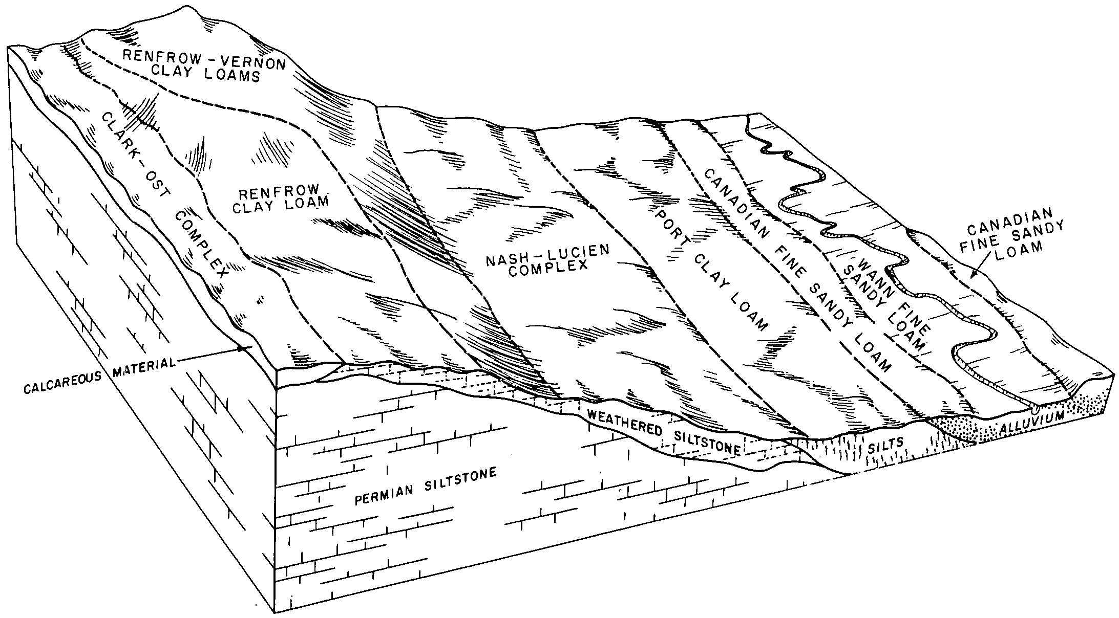
Lucien-Grainola-Zaneis complex, 5 to 12 percent slopes | LzD | 36012 | 382191 | 30c0k | ok031 | 1965 | 1:24000 |
Zaneis-Grainola-Lucien complex, 5 to 20 percent slopes | Lz | 16242 | 382237 | dtr7 | ok033 | 1961 | 1:24000 |
Steedman-Lucien complex, 5 to 12 percent slopes, very rocky | StLE | 764 | 2516358 | 1t800 | ok037 | 1952 | 1:24000 |
Foraker-Shidler-Lucien complex, 3 to 12 percent slopes, very rocky | FSLE | 744 | 2516366 | 1t7yn | ok037 | 1952 | 1:24000 |
Lucien-Rock outcrop complex, 5 to 20 percent slopes | LrE | 14835 | 382327 | dtv4 | ok039 | 1973 | 1:24000 |
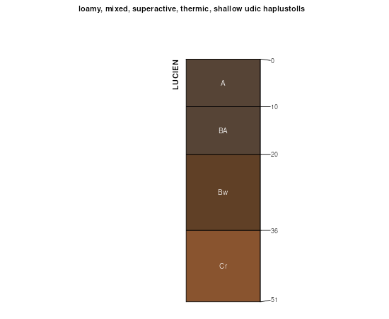
Lucien-Nash complex, 5 to 12 percent slopes | 21 | 72180 | 382640 | dv57 | ok051 | 1975 | 1:24000 |
Nash-Lucien complex, 1 to 5 percent slopes | 30 | 23580 | 382650 | dv5k | ok051 | 1975 | 1:24000 |
Zaneis, Lucien, and Grainola soils, 5 to 12 percent slopes | ZvD | 107302 | 383269 | 2xm2m | ok067 | 1967 | 1:24000 |
Kingfisher-Lucien complex, 5 to 8 percent slopes, eroded | KgD3 | 10329 | 383395 | dvyl | ok073 | 1960 | 1:24000 |
Masham-Lucien complex, 5 to 20 percent slopes | VeF | 9389 | 383543 | dw3c | ok081 | 1966 | 1:24000 |
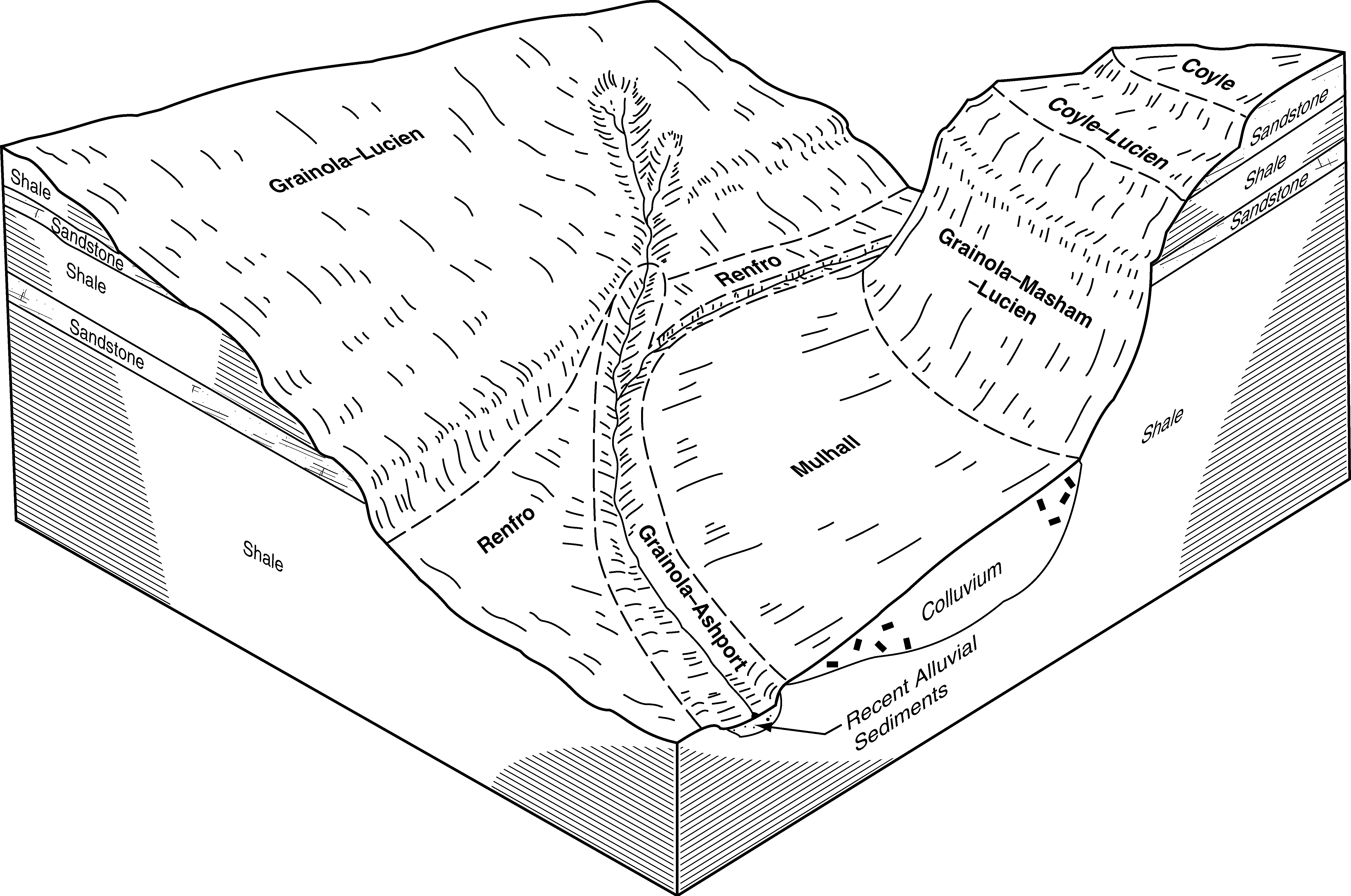
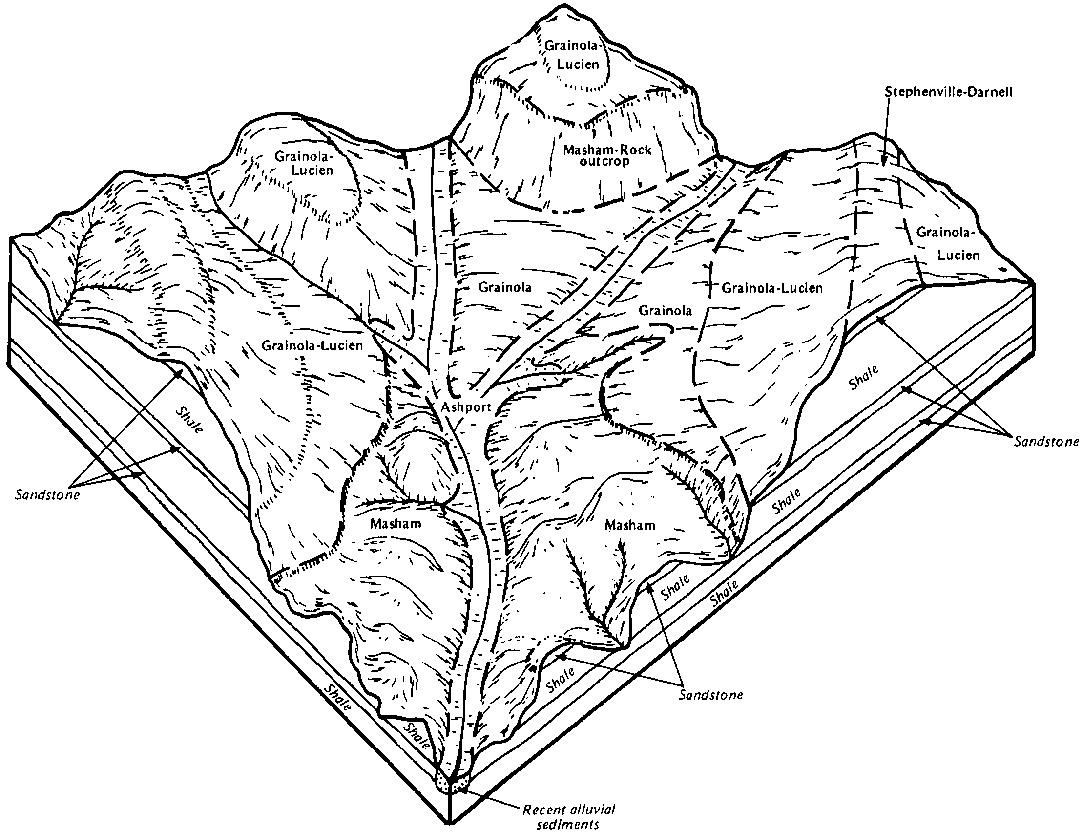
Grainola-Lucien complex, 5 to 12 percent slopes | GrLE | 209 | 383622 | 2wrk2 | ok083 | 1994 | 1:12000 |
Grainola-Masham-Lucien complex, 5 to 40 percent slopes, very bouldery | GMLG | 46 | 383614 | 2wrk3 | ok083 | 1994 | 1:12000 |
Nash-Lucien complex, 5 to 12 percent slopes | 33 | 63433 | 383790 | dwcb | ok087 | 1976 | 1:24000 |
Nash-Lucien complex, 3 to 5 percent slopes | 32 | 13341 | 383789 | dwc9 | ok087 | 1976 | 1:24000 |
Grainola-Lucien complex, 5 to 12 percent slopes | GrLE | 34415 | 384059 | 2wrk2 | ok103 | 1994 | 1:24000 |
Grainola-Masham-Lucien complex, 5 to 40 percent slopes, very bouldery | GMLG | 21814 | 384052 | 2wrk3 | ok103 | 1994 | 1:24000 |
Grainola-Lucien complex, 1 to 5 percent slopes | GrLC | 17674 | 384058 | dwmz | ok103 | 1994 | 1:24000 |
Coyle-Lucien complex, 1 to 5 percent slopes | CoLC | 5717 | 384040 | dwmd | ok103 | 1994 | 1:24000 |
Kingfisher-Lucien complex, 1 to 5 percent slopes | KgLC | 3636 | 384067 | 2tq6f | ok103 | 1994 | 1:24000 |
Steedman-Lucien complex, 3 to 15 percent slopes | 57 | 116942 | 623452 | nxrc | ok113 | 1975 | 1:24000 |
Lucien-Coyle complex, 3 to 8 percent slopes | 13 | 75423 | 623408 | nxpy | ok113 | 1975 | 1:24000 |
Steedman-Lucien complex, 15 to 25 percent slopes | 58 | 31915 | 623453 | nxrd | ok113 | 1975 | 1:24000 |
Coyle-Lucien complex, 3 to 12 percent slopes | 60 | 9796 | 623455 | nxrg | ok113 | 1975 | 1:24000 |
Foraker-Shidler-Lucien complex, 3 to 12 percent slopes, very rocky | FSLE | 27463 | 1675942 | 1t7yn | ok117 | 2007 | 1:24000 |
Coyle-Lucien complex, 1 to 5 percent slopes | CoLC | 13245 | 1423150 | 1jrx2 | ok117 | 2007 | 1:24000 |
Grainola-Shidler-Lucien complex, 1 to 20 percent slopes, very rocky | GSLF | 12967 | 1675936 | 1t7yg | ok117 | 2007 | 1:24000 |
Grainola-Lucien complex, 1 to 5 percent slopes | GrLC | 12681 | 1677338 | 1t9dp | ok117 | 2007 | 1:24000 |
Grainola-Lucien complex, 5 to 12 percent slopes | GrLE | 11992 | 1423157 | 2wrk2 | ok117 | 2007 | 1:24000 |
Steedman-Lucien complex, 5 to 12 percent slopes, very rocky | StLE | 10897 | 1675984 | 1t800 | ok117 | 2007 | 1:24000 |
Grainola-Rock outcrop-Lucien complex, 5 to 20 percent slopes | GRLF | 6328 | 1675908 | 1t7xk | ok117 | 2007 | 1:24000 |
Steedman-Lucien complex, 1 to 5 percent slopes, very rocky | StLC | 5311 | 1677022 | 1t92h | ok117 | 2007 | 1:24000 |
Coyle-Lucien complex, 1 to 5 percent slopes, eroded, very rocky | CoLC2 | 2917 | 1677024 | 1t92k | ok117 | 2007 | 1:24000 |
Steedman-Lucien complex, 12 to 45 percent slopes, very rocky | StLG | 1025 | 1675985 | 1t801 | ok117 | 2007 | 1:24000 |
Grainola-Masham-Lucien complex, 5 to 40 percent slopes, very bouldery | GMLG | 22 | 1883786 | 2wrk3 | ok117 | 2007 | 1:24000 |
Grainola-Lucien complex, 5 to 12 percent slopes | GrLE | 21975 | 1907386 | 2wrk2 | ok119 | 1983 | 1:24000 |
Foraker-Shidler-Lucien complex, 1 to 12 percent slopes, very rocky | FSLE | 13303 | 1907654 | 22127 | ok119 | 1983 | 1:24000 |
Grainola-Shidler-Lucien complex, 1 to 20 percent slopes, very rocky | GSLF | 12181 | 1907651 | 22124 | ok119 | 1983 | 1:24000 |
Grainola-Lucien complex, 1 to 5 percent slopes | GrLC | 10364 | 1907385 | 220sk | ok119 | 1983 | 1:24000 |
Coyle-Lucien complex, 1 to 5 percent slopes | CoLC | 4989 | 1907650 | 22123 | ok119 | 1983 | 1:24000 |
Coyle-Lucien complex, 1 to 5 percent slopes, eroded, rocky | CoLC2 | 76 | 1900516 | 21smz | ok119 | 1983 | 1:24000 |
Steedman-Lucien complex, 1 to 5 percent slopes, very rocky | StLC | 8 | 1900521 | 21sn4 | ok119 | 1983 | 1:24000 |
Grainola-Lucien complex, 5 to 12 percent slopes | 18 | 8749 | 384803 | 2wrk2 | ok133 | 1976 | 1:24000 |
Zaneis-Grainola-Lucien complex, 5 to 12 percent slopes | Lz | 37710 | 384867 | dxh2 | ok137 | 1960 | 1:24000 |