Official Series Description


Lab Data Summary

Aggregate lab data for the LONEWOOD soil series. This aggregation is based on all pedons with a current taxon name of LONEWOOD, and applied along 1-cm thick depth slices. Solid lines are the slice-wise median, bounded on either side by the interval defined by the slice-wise 5th and 95th percentiles. The median is the value that splits the data in half. Five percent of the data are less than the 5th percentile, and five percent of the data are greater than the 95th percentile. Values along the right hand side y-axis describe the proportion of pedon data that contribute to aggregate values at this depth. For example, a value of "90%" at 25cm means that 90% of the pedons correlated to LONEWOOD were used in the calculation. Source: KSSL snapshot . Methods used to assemble the KSSL snapshot used by SoilWeb / SDE

Click the image to view it full size.

Pedons used in the lab summary:

MLRALab IDPedon IDTaxonnameCINSSL / NASIS ReportsLink To SoilWeb GMap
12289KY-057-00989KY-057-009Lonewood4Primary | Supplementary | Taxonomy | Pedon | Water Retention | Correlation | Andic Soil Properties36.7436905,-85.2907791
12597P040297TN035005Lonewood7Primary | Supplementary | Taxonomy | Pedon | Water Retention | Correlation | Andic Soil Properties35.8418045,-85.0673599

Water Balance

Monthly water balance estimated using a leaky-bucket style model for the LONEWOOD soil series. Monthly precipitation (PPT) and potential evapotranspiration (PET) have been estimated from the 50th percentile of gridded values (PRISM 1981-2010) overlapping with the extent of SSURGO map units containing each series as a major component. Monthly PET values were estimated using the method of Thornthwaite (1948). These (and other) climatic parameters are calculated with each SSURGO refresh and provided by the fetchOSD function of the soilDB package. Representative water storage values (“AWC” in the figures) were derived from SSURGO by taking the 50th percentile of profile-total water storage (sum[awc_r * horizon thickness]) for each soil series. Note that this representation of “water storage” is based on the average ability of most plants to extract soil water between 15 bar (“permanent wilting point”) and 1/3 bar (“field capacity”) matric potential. Soil moisture state can be roughly interpreted as “dry” when storage is depleted, “moist” when storage is between 0mm and AWC, and “wet” when there is a surplus. Clearly there are a lot of assumptions baked into this kind of monthly water balance. This is still a work in progress.

Click the image to view it full size.


Click the image to view it full size.

Sibling Summary

Siblings are those soil series that occur together in map units, in this case with the LONEWOOD series. Sketches are arranged according to their subgroup-level taxonomic structure. Source: SSURGO snapshot , parsed OSD records and snapshot of SC database .

Click the image to view it full size.

Select annual climate data summaries for the LONEWOOD series and siblings. Series are sorted according to hierarchical clustering of median values. Source: SSURGO map unit geometry and 1981-2010, 800m PRISM data .

Click the image to view it full size.

Geomorphic description summaries for the LONEWOOD series and siblings. Series are sorted according to hierarchical clustering of proportions and relative hydrologic position within an idealized landform (e.g. top to bottom). Most soil series (SSURGO components) are associated with a hillslope position and one or more landform-specific positions: hills, mountain slopes, terraces, and/or flats. Proportions can be interpreted as an aggregate representation of geomorphic membership. The values printed to the left (number of component records) and right (Shannon entropy) of stacked bars can be used to judge the reliability of trends. Small Shannon entropy values suggest relatively consistent geomorphic association, while larger values suggest lack thereof. Source: SSURGO component records .

Click the image to view it full size.

Click the image to view it full size.

Click the image to view it full size.

Click the image to view it full size.

There are insufficient data to create the 3D flats position figure.

Competing Series

Soil series competing with LONEWOOD share the same family level classification in Soil Taxonomy. Source: parsed OSD records and snapshot of the SC database .

Click the image to view it full size.

Select annual climate data summaries for the LONEWOOD series and competing. Series are sorted according to hierarchical clustering of median values. Source: SSURGO map unit geometry and 1981-2010, 800m PRISM data .

Click the image to view it full size.

Geomorphic description summaries for the LONEWOOD series and competing. Series are sorted according to hierarchical clustering of proportions and relative hydrologic position within an idealized landform (e.g. top to bottom). Proportions can be interpreted as an aggregate representation of geomorphic membership. Most soil series (SSURGO components) are associated with a hillslope position and one or more landform-specific positions: hills, mountain slopes, terraces, and/or flats. The values printed to the left (number of component records) and right (Shannon entropy) of stacked bars can be used to judge the reliability of trends. Shannon entropy values close to 0 represent soil series with relatively consistent geomorphic association, while values close to 1 suggest lack thereof. Source: SSURGO component records .

Click the image to view it full size.

Click the image to view it full size.

Click the image to view it full size.

Click the image to view it full size.

Click the image to view it full size.

Soil series sharing subgroup-level classification with LONEWOOD, arranged according to family differentiae. Hovering over a series name will print full classification and a small sketch from the OSD. Source: snapshot of SC database .

Block Diagrams

Click a link below to display the diagram. Note that these diagrams may be from multiple survey areas.

  1. KY-2010-09-03-25 | Cumberland County - 1998

    Relationship of the soils in Garmon-Newbern-Carpenter general soil map unit and the underlying material (Soil Survey of Cumberland County, Kentucky; 1998).

  2. KY-2010-09-03-26 | Cumberland County - 1998

    Typical pattern of the soils and the underlying material in the Dewey-Lonewood-Caneyville general soil map unit (Soil Survey of Cumberland County, Kentucky; 1998).

  3. TN-2010-11-02-26 | Overton County - 2005

    The relationship of soils and landscapes in the Nella-Talbott and Lonewood-Clarkrange general soil map units (Soil Survey of Overton County, Tennessee; 2005).

  4. TN-2010-11-02-29 | Overton County - 2005

    The relationship of soils and landscapes in the Lily-Gilpin and Gilpin-Shelocta-Bouldin general soil map units (Soil Survey of Overton County, Tennessee; 2005).

  5. TN-2010-11-02-32 | Rhea County - 2005

    The relationship of soils, geology, and parent materials in the Lily-Gilpin-Ramsey and Gilpin-Allen-Bouldin-Petros general soil map units (Soil Survey of Rhea County, Tennessee; 2005).

  6. TN-2012-03-16-11 | Grundy County - 2001

    Typical pattern of soils and the underlying material in the Beersheba-Lonewood-Lily general soil map unit (Soil Survey of Grundy County, TN; 2001).

Map Units

Map units containing LONEWOOD as a major component. Limited to 250 records.

Map Unit Name Symbol Map Unit Area (ac) Map Unit Key National Map Unit Symbol Soil Survey Area Publication Date Map Scale
Lonewood loam, 6 to 12 percent slopesLoC30315924971qg3wky00120061:12000
Lonewood loam, 2 to 6 percent slopesLoB15415924961qg3vky00120061:12000
Lonewood loam, 6 to 12 percent slopes, erodedLoC2867552527ljygky05119941:24000
Lonewood loam, 2 to 6 percent slopesLoB208552526ljyfky05119941:24000
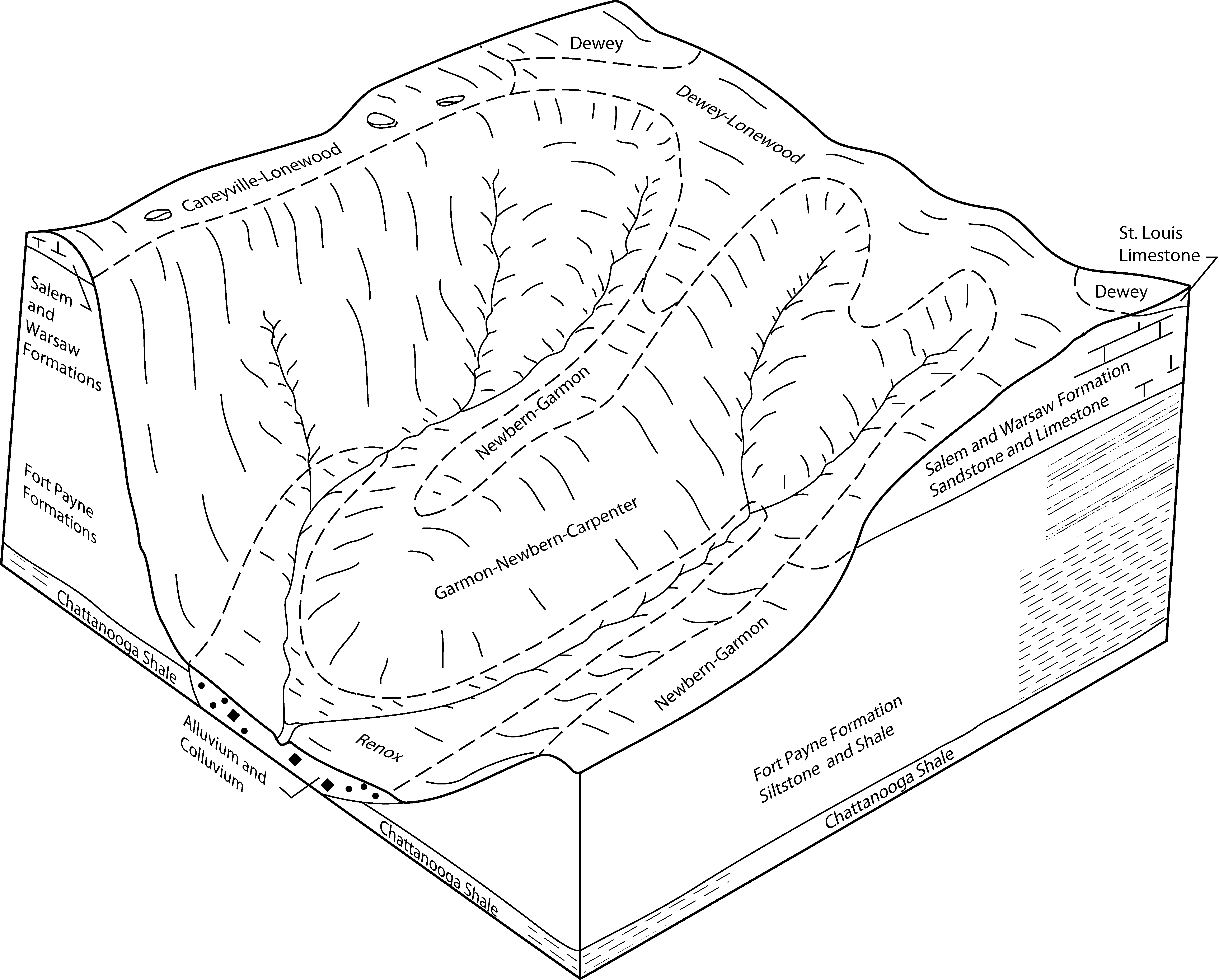
Dewey-Lonewood complex, 12 to 25 percent slopesDmD13665551442lhtgky05719911:20000
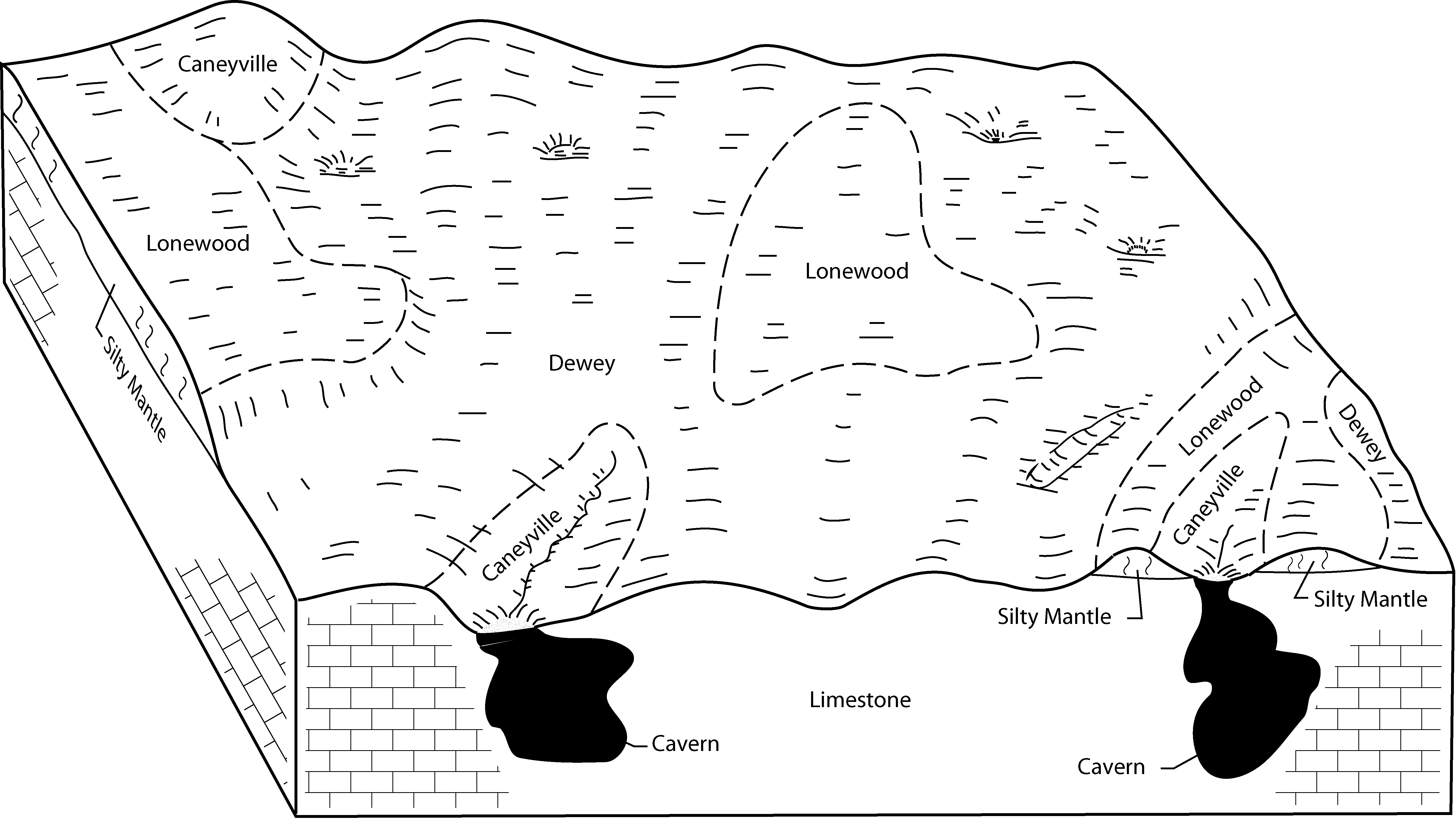
Caneyville-Lonewood complex, rocky, 6 to 25 percent slopes, erodedCaD27830551434lht6ky05719911:20000
Lonewood silt loam, 6 to 12 percent slopes, erodedLdC23280551458lhtzky05719911:20000
Lonewood silt loam, 2 to 6 percent slopesLdB605551457lhtyky05719911:20000
Lonewood loam, 2 to 6 percent slopesLoB15720552494ljxdky20719791:20000
Lonewood loam, 6 to 12 percent slopesLoC4270552495ljxfky20719791:20000
Lonewood silt loam, 4 to 12 percent slopesLwC156524446klqmtn01519991:24000
Caneyville-Lonewood complex, 6 to 25 percent slopes, eroded, rockyCaD21807531105ktnftn02720021:24000
Lonewood loam, 5 to 12 percent slopesLwC156595238882tnvrtn03519981:24000
Lonewood loam, 2 to 5 percent slopesLwB27345238872tnvbtn03519981:24000
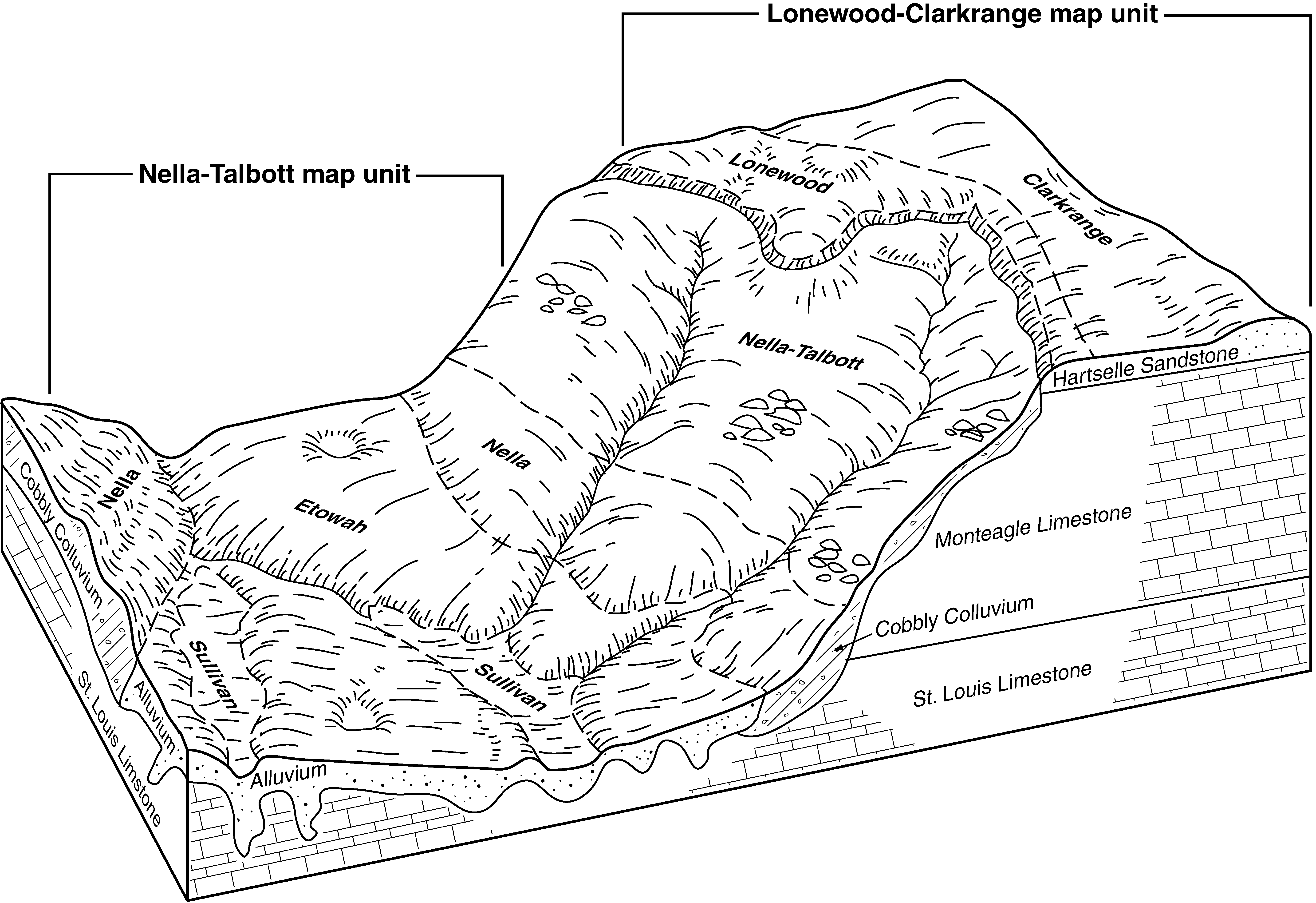
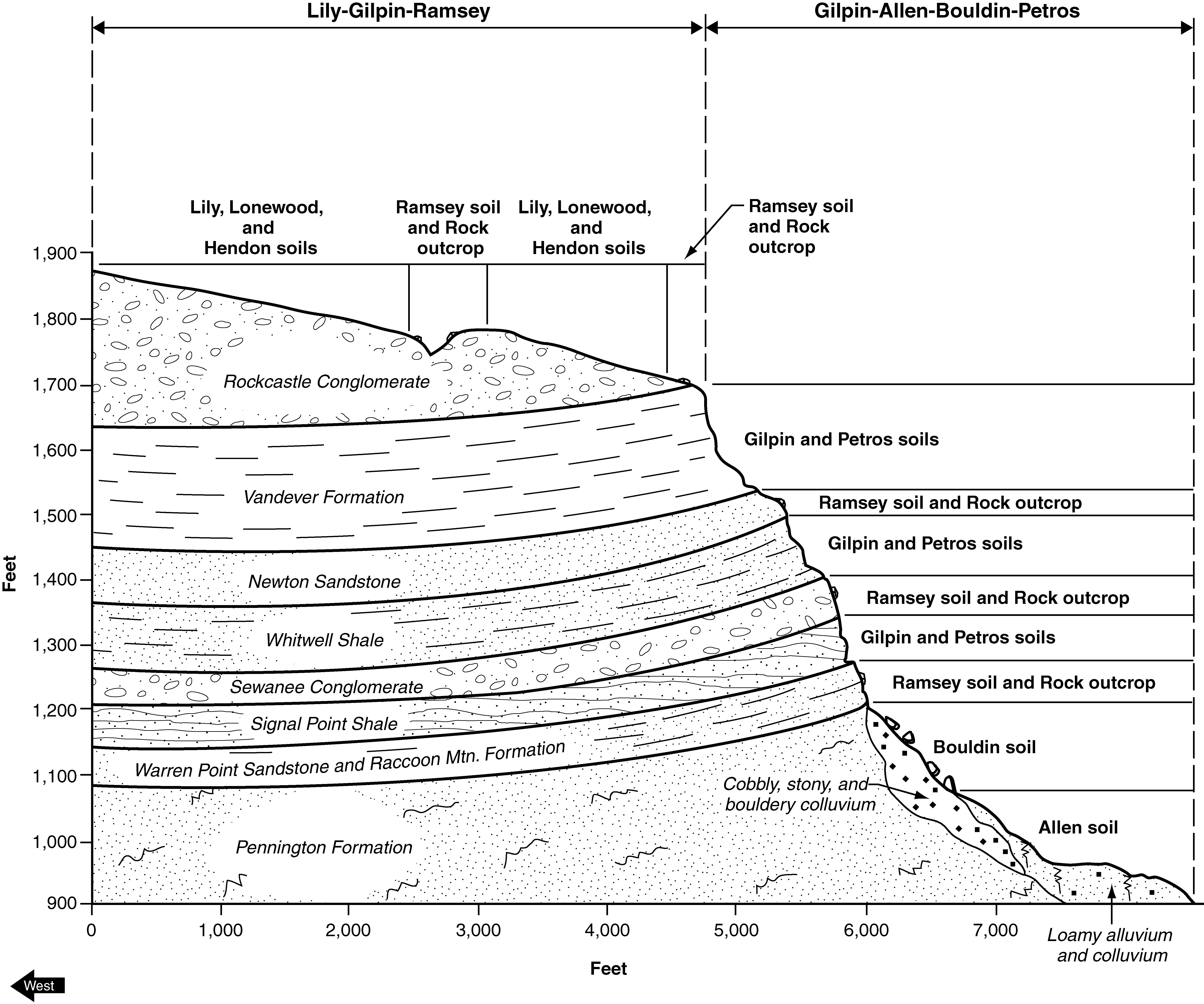
Lily-Lonewood complex, 5 to 12 percent slopes, rockyLnC10605238862w2nstn03519981:24000
Lonewood silt loam, 2 to 5 percent slopesLoB215325252542tnvftn06119901:24000
Lonewood silt loam, 5 to 12 percent slopesLoC86825252552tnvjtn06119901:24000
Lonewood silt loam, 2 to 6 percent slopesLnB499310178692w2nxtn06519801:15840
Linker loam, rolling phase (Lonewood)Lb1757526283knmwtn11519511:20000
Linker loam, eroded rolling phase (Lonewood)Lc242526284knmxtn11519511:20000
Lonewood loam, 5 to 12 percent slopesLwC93478433702tnvrtn13320031:24000
Lonewood loam, 2 to 5 percent slopesLwB27558433692tnvbtn13320031:24000
Lonewood-Hendon complex, 5 to 12 percent slopesLnC3360728872sgg0tn14320031:24000
Lonewood-Hendon complex, 2 to 5 percent slopesLnB912728871sgfztn14320031:24000
Lonewood silt loam, 5 to 12 percent slopesLoC11614737972tnvjtn14520051:24000
Lonewood silt loam, 2 to 5 percent slopesLoB10514737962tnvftn14520051:24000
Lonewood silt loam, 5 to 12 percent slopesLoC73525296282tnvjtn15319951:24000
Lonewood silt loam, 2 to 5 percent slopesLoB54665296272tnvftn15319951:24000
Lonewood-Lily complex, 5 to 12 percent slopesLwC789624507382tnv1tn17719651:15840
Lonewood loam, 2 to 5 percent slopesLoB230324507222tnvbtn17719651:15840
Lonewood loam, 5 to 12 percent slopesLdC4278624541662tnvrtn60419741:20000
Lonewood silt loam, 5 to 12 percent slopesLoC150825286612tnvjtn60419741:20000
Lonewood silt loam, 2 to 5 percent slopesLoB38725286602tnvftn60419741:20000
Lonewood-Lily complex, 5 to 12 percent slopesLeC304624414042tnv1tn60419741:20000
Lonewood-Lily complex, 2 to 5 percent slopesLeB241624541642w2nwtn60419741:20000
Linker loam, 5 to 12 percent slopes, erodedLrC243824274672mgzdtn61019601:15840
Linker loam, 5 to 12 percent slopesLrC21824274662mgzctn61019601:15840
Lonewood silt loam, 5 to 12 percent slopesLoC555624391072mw2wtn62920031:24000
Lonewood silt loam, 2 to 5 percent slopesLoB229624391062mw2vtn62920031:24000
Lonewood silt loam, 5 to 12 percent slopesLoC151817077511vb1rtn65020081:12000
Lonewood silt loam, 2 to 5 percent slopesLoB74024060822lrqktn65020081:12000
Lonewood-Clarkrange complex, 2 to 6 percent slopesLoC2630724391752mw52tn70119851:24000

Map of Series Extent

Approximate geographic distribution of the LONEWOOD soil series. To learn more about how this distribution was mapped, or to compare this soil series extent to others, use the Series Extent Explorer (SEE) application. Source: generalization of SSURGO geometry .